Information for pilots planning to fly in the Solent or Southampton area
Infringement hot-spots
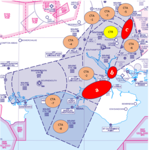
Infringement hot spots (2023)
a Solent CTA 2 over the Solent and the north coast of the Isle of Wight
b Solent CTR in the vicinity of the Calshot Beach VRP or to the west of the Lee-on-Solent Aerodrome Traffic Zone
c Solent CTA-3/CTA-5 in the vicinity of the New Alresford VRP
Downloads and links
- Southampton and Solent Frequency Monitoring Code (FMC) Guide
- Wessex LAIT Tips Southampton and Bournemouth Airports
- Wessex LAIT Tips Farnborough Airport
- Narrative to download and share: Hot-spots in the Solent and Southampton area
Wessex LAIT podcast
- How Local Airspace Infringement Teams work looks at the work of the Wessex LAIT to help reduce infringements.
Hot-spot narrative
This infringement narrative is an update to that issued as the UK emerged from its national COVID-19 associated lockdowns and is focusing on the identified infringement hot-spot in the UK in the vicinity of Southampton Airport and The Solent.
In 2022 there were 118 reported airspace infringements of the Southampton CTR/Solent CTA. To 21 June 2023, the number of reported airspace infringements this year has reached 51 and week on week infringements continue to occur.
Air Traffic Control and Solent Radar
The primary function of Southampton Air Traffic Control (ATC) is to provide a service to aircraft arriving to and departing from Southampton International Airport (and some Bournemouth Airport associated traffic), as well as those aircraft that wish to enter, operate in or transit through the Southampton/Solent controlled airspace.
Solent Radar is also responsible, by virtue of delegated airspace, for part of some lower levels of the London Terminal Control Area (LTMA) (those that lie immediately above the Solent CTA), together with providing a function to certain Farnborough departures. This creates a busy environment, where extensive co-ordination takes place beyond what may be apparent by just listening to the radio.
Commercial Air Transport aircraft can be operating as low as 500 feet above the base of controlled airspace. The complexities associated with the diverse controlling and airspace management/coordination tasks means that any airspace infringement may not only compromise safety but have an impact on the operations at three airports.
An infringing aircraft that is not radar identified by Solent Radar becomes unknown traffic; a separation standard of 3NM laterally or 3,000 feet vertically is required between that aircraft and IFR aircraft operating within Southampton/Solent controlled airspace. All infringements pose a significant risk to safety and controller’s workload.
Solent airspace
The Solent airspace comprises the Southampton Control Zone (CTR, surface to 2,000 feet AMSL) and eight Solent Control Areas (CTA) as depicted in Figure 1. All airspace is Class D.
| Southampton CTR | Surface – 2000 feet AMSL |
| Solent CTA-1 | 1,500 feet AMSL – 5,500 feet AMSL |
| Solent CTA-2 | 2,000 feet AMSL – 5,500 feet AMSL
Note: Extends over Southampton and Bournemouth CTR |
| Solent CTA-3 | 2,000 feet AMSL – 5,500 feet AMSL |
| Solent CTA-4 | 2,500 feet AMSL – 5,500 feet AMSL |
| Solent CTA-5 | 2,500 feet AMSL – 5,500 feet AMSL |
| Solent CTA-6 | 3,000 feet AMSL – 5,500 feet AMSL |
| Solent CTA-7 | 3,500 feet AMSL – 5,500 feet AMSL |
| Solent CTA-8 | 3,500 feet AMSL – 5,500 feet AMSL |
Known infringement hot-spots
There are three areas (as depicted in figure 1 by the red shapes a,b and c) in which most airspace infringements occur.
Figure 1 correct as at AIRAC 06/2023
a – Solent CTA 2 over The Solent and the north coast of the Isle of Wight
When flying over the water, pilots aim to fly as high as possible and then inadvertently exceed the 2,000 feet AMSL base. This may be compounded by flying on the incorrect altimeter setting where the Southampton QNH should be used. The correct Southampton QNH should be used and can be obtained via several sources such as the Southampton ATIS (130.880 MHz), when monitoring 120.230 MHz when using the Solent FMC; VOLMET on 128.600 MHz (London VOLMET) or simply by asking Solent Radar on 120.230 MHz.
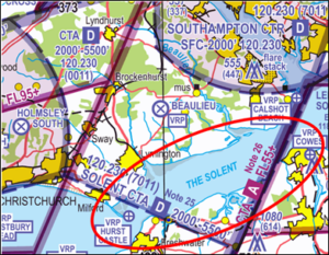
Figure 2 Hot-spot a – Solent CTA 2 (AIRAC 06/2023)
b – Southampton CTR in the vicinity of the Calshot Beach Visual Reference Point (VRP) or to the west of the Lee-on-Solent Aerodrome Traffic Zone
Most of these infringements involve aircraft arriving or departing from Lee-on-Solent Aerodrome (EGHF) or when flying a wider visual circuit/delaying action in the visual circuit at Lee-on-Solent to sequence high-performance aircraft behind microlights/slower aircraft. The CAA is noting a rising number of occurrences when pilots are operating on the Lee-on-Solent conspicuity code of 4306. This code should only be displayed when 4306 prior to joining or leaving the visual circuit. When inbound, as a guide, this should be done at any of the following locations: Calshot, Cowes, Spinnaker Tower or Wickham. Outside of these areas, and subject to retaining situational awareness on other Lee-on-Solent traffic, pilots are encouraged to use the Solent FMC as soon as possible.
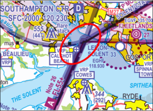
Figure 3 Hot spot b – Solent CTR (AIRAC 06/2023)
c – Solent CTA-3/CTA-5 in the vicinity of the New Alresford VRP
The VRP is located at 510519.70N 0010859.10W which in underneath CTA-5 (base 2,500 feet AMSL) and is the point where the B3047 road crosses the railway line (colloquially known as The Watercress Line) to the east of New Alresford town. This is a common VRP used for navigation. Since the expansion in the use of VFR Moving Maps, another point that has become a commonly used turning point is the IFR waypoint called HANKY; this point lies 0.3NM northeast of the boundary of CTA-5 and is not associated with any geographical VFR navigation feature. Infringements in this area frequently result from pilots entering the CTAs:
- laterally due to deviating from their planned route which is so close to the edge of controlled airspace because they are routing over the New Alresford VRP or IFR way point at HANKY.
- laterally when flying VFR via HANKY and experiencing a VFR Moving Map failure leading to a loss of situational awareness as to their position.
- vertically when flying at or slightly below the base of controlled airspace and then inadvertently exceeding the base altitude. This may be compounded by flying on the incorrect altimeter setting when the Southampton QNH should be used.
It is important to ensure that when flying VFR, you do not rely on IFR waypoints but instead use appropriate ground features along your route to increase your situational awareness if your electronic device should fail. Again the correct Southampton QNH should be used and can be obtained via several sources such as the Southampton ATIS (130.880 MHz), when monitoring 120.230 MHz when using the Solent FMC; VOLMET on 128.600 MHz (London VOLMET) or simply by asking Solent Radar on 120.230 MHz.
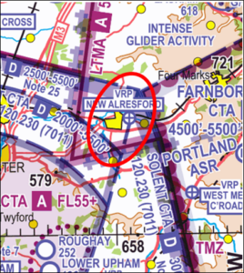
Figure 4 Hot spot c – Solent CTA-3 CTA-5 (AIRAC 06/2023)
Preventing an airspace infringement
The Airspace & Safety Initiative website provides extensive advice on how to avoid the risk of infringing airspace. Pilots are strongly encouraged to:
Take 2
An initiative established through the Local Airspace Infringement Teams (LAIT) is to TAKE2. By remaining at least 200 feet below the base, or 2NM horizontally away from the edge of a block of controlled airspace then, any inadvertent deviation from level flight or planned course could be identified in sufficient time to prevent an airspace infringement. As mentioned in the introduction, it is especially important when flying ‘under’ the Solent CTA‐2 – i.e. below 2,000 feet. A radar controller can usually see traffic operating beneath controlled airspace while controlling inbound traffic to Southampton (and in principle in this area, Bournemouth too) and must expect such aircraft to remain outside the CTA‐2. Any vertical deviation that results in an aircraft entering the CTA‐2 without a clearance, can immediately cause a loss of separation with an aircraft already established within the airspace. This quickly becomes a significant safety event employing avoiding action, creating a highly elevated workload with yet greater risk, and resulting in a substantial amount of reporting action and investigation that a loss of separation entails. An aircraft just ‘popping up for a moment’ can easily be as significant as a horizontal infringement from an ATC perspective.
Use the appropriate FMC (Listening Squawk) and listen out
The airspace below the CTA‐2 is Class G airspace (uncontrolled). There is no requirement to receive a service from either Bournemouth ATC (to the west) or Southampton ATC (the controlling authority).
However, the introduction of the Frequency Monitoring Code (7011 for Southampton/Solent Radar 120.230MHz, or 0011 for Bournemouth Radar 119.480MHz) enables ATC at those units to observe an aircraft that may be of potential conflict to their traffic inside controlled airspace and interrogate such an aircraft when appropriate.
The recommended area within which the Solent FMC should be used is depicted within the black lines in figure 5. The use of this FMC has been proven to prevent infringements and reduce the severity of such occurrences by enhancing the controllers’ and pilots’ situational awareness and creating a safer and more predictable situation than would otherwise prevail.
The agreed ‘demarcation’ line between the Solent and Bournemouth FMC is a line orientated northwest to southeast between Stoney Cross and Hurst Castle; to the west it is Bournemouth (0011/119.480MHz) and to the east is Solent Radar (7011/120.230MHz).
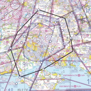
Figure 5 Recommended Solent FMC area (AIRAC 06/2023)
Obtain an Air Traffic Service (ATS) from a Lower Airspace Radar Service (LARS)
If you would prefer to obtain an ATS rather than use an FMC, then a LARS is provided by Farnborough Radar to the north and northeast of the Southampton CTR, by Boscombe Down to the north and northwest of the CTR, and by Bournemouth Radar to the west, southwest and south of the CTR. All services provided by LARS are in line with CAP 774 – UK Flight Information Services.
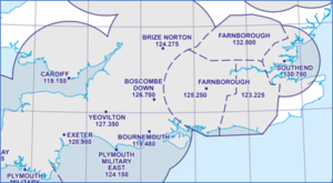
Figure 6 Extract from ENR 6-1 (LARS) AIRAC 06/23
Set the right QNH
The base of controlled airspace is determined by the local Southampton QNH, not the Portland RPS. A difference of 3‐4 hPa is not unusual and aircraft flying close to the base of controlled airspace can inadvertently infringe just by having the wrong (inappropriate) QNH selected.
If appropriate – request a clearance. If for any reason a climb is required above the base of 2,000 feet in CTA‐2, then a clearance must be obtained. Depending on a variety of factors, not least the runway in use and traffic situation at the time, this may well be available. By obtaining a clearance to enter controlled airspace when appropriate, ATC can control more effectively and ensure safety is maintained.
Always use a VFR Moving Map
There are many reasons why a pilot can lose situational awareness of their position that may then result in an airspace infringement. Whether flying recreationally or carrying out an instructional flight, the correct use of a Moving Map is known to reduce that risk and assist in increasing pilot capacity.
When flying a route that requires changes in altitude due to, for example, CTAs it is good practice to annotate on your chart climb and descent points that take into account the requirements of the airspace and should incorporate the ‘Take 2’ guidance; these points should then be noted on your PLOG and added as separate waypoints on your VFR Moving Map device to act as triggers.
The use of any equipment/technology carries its own set of Threats and Errors; the European General Aviation Safety Team, Safety Promotion Leaflet, Using Advanced Navigation Technology Safely offers advice and guidance in their use along with the CAA’s Safety Sense Leaflet 29 – VFR Moving Map Devices.