Updated to incorporate changes to the area of the Manchester Control Zone that was formerly the Manchester Low Lever Route and is now the Class G Restricted Area EGR323 – North West Transit Corridor.
Restricted Area EGR323 North West Transit Corridor
Restricted Area EGR323 North West Transit Corridor (NWTC) allows general aviation aircraft to pass through the airspace between Liverpool and Manchester airports.
![]()
To operate within this restricted area you must:
- fly an aircraft with a Maximum Certified Take-Off Mass of 40,000 KG or less
- maintain a minimum in flight visibility of 5 KM
- use the Manchester or Liverpool QNH (altimeter) setting
- fly below 1500 feet AMSL
- keep your indicated airspeed below 140 KTS
Detailed information on the NWTC boundaries and operational requirements is included in the UK Aeronautical Information Circular AIC Y 004/2025.
Local Airspace Infringement Team (LAIT)
The North West LAIT serves Manchester and Liverpool CTR/CTA, Hawarden RMZ and Barton ATZ. For more information email [email protected]
North West hot-spots
This infringement update has been written by the Aerodrome Flight Information Service Officers (AFISO) at Manchester Barton Aerodrome who are members of the Northwest Local Airspace Infringement Team.
ATZ infringements
Whilst ATZ infringements have always been reportable as an occurrence (a breach of Rule 11 of The Rules of the Air Regulations 2015), the national focus on airspace infringement prevention and improved reporting have identified a number of common factors which have led to such infringements.
In 2024 there were 95 reported infringements of ATZs in the UK. This type of airspace infringement is a particular risk to the operation at Manchester Barton Aerodrome. This article is intended to give helpful guidance and useful tips to assist pilots in preventing an ATZ infringement at the Aerodrome and may also be relevant at other ATZs elsewhere.
An ATZ is established to give protection to aircraft at the critical stages of flight when departing, arriving, and flying in the vicinity of the aerodrome and it can be a busy area of airspace. Barton is an aerodrome used by many aircraft which vary greatly in performance levels; compliance with Rule 11 of the Rules of the Air Regulations 2015 is essential to ensure that the ATZ’s protection is an effective mitigation against a mid-air collision.
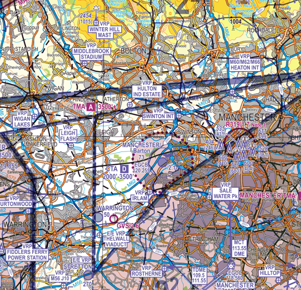
The Barton ATZ
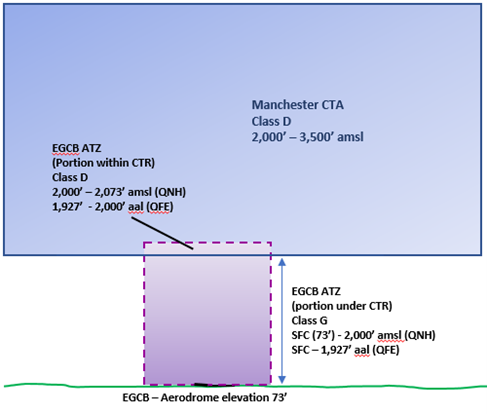
The Barton ATZ has a 2NM radius and extends to 2,000 feet above aerodrome level. It sits underneath the Manchester Control Area (CTA) with vertical limits of 2,000 feet – 3,500 feet AMSL (based on the Manchester QNH) and against the Manchester CTR which itself extends from the Surface to 3,500 feet AMSL (based on the Manchester QNH) as depicted below. The ATZ it is a non-standard ATZ as it excludes the portion of the circle that would lie within the Manchester CTR. The ATZ is active during the published hours of the Aerodrome Flight Information Service as per the entry in the UK AIP at EGCB AD 2.17.
The ATZ lies primarily within Class G airspace; however, the top of the ATZ lies above the base of the Class D Manchester CTA (Manchester Barton aerodrome elevation being 73 feet AMSL). This also means that it is impossible to transit at the top height (2,000 feet AGL) or above the Barton ATZ without clearance from Manchester ATC. Aircraft arriving to and flying visual circuits at Barton will do so on the Barton QFE; departing aircraft will be issued the Manchester QNH.
Extract from: Sheet 5 Central England and Wales Edition 14 (2021)
Reported infringements and local awareness
Each year, most of the infringements involved aircraft that were inbound to land with a small number by aircraft not landing but flying within the vicinity.
Manchester Barton Aerodrome is a member of the Northwest Local Airspace Infringement Team (LAIT). Significant local awareness and education material has resulted in a large reduction in the number of infringements involving locally based aircraft. This information aims to further extend this awareness and educate pilots around the country who may be visiting the aerodrome or passing the vicinity.
Common causal factors
A study of the infringements breaks down the majority of causal factors into the following areas:
Lack of awareness of Rule 11 – A number of pilots were unaware that they must not enter the ATZ (even if they have previously remained on frequency in the local area) until the AFISO has passed updated aerodrome information directly to them. Most incidences cited busy RTF as a contributary factor, with the PIC not able to make an initial joining call to obtain airfield information, or having been asked to “standby” due to AFISO workload. See the below section Plan Ahead for guidance.
Further information on Rule 11 and ATZs can be found in this leaflet.
Incorrect frequency selection – Barton Information frequency is 120.255 MHz and has a Designated Operational Coverage (DOC) of 10NM radius and up to 3,000 feet amsl. The second most common cause for Barton ATZ infringements is incorrect frequency selection and pilots continuing their flight into the ATZ having not received a response. Rule 11 applies to aerodromes with a Flight Information Service (FIS) centre during the notified hours of watch of the FIS unit as notified in the UK AIP or as amended by NOTAM. If you don’t receive a response during these hours, check your frequency selection and avoid the ATZ entirely.
Lack of pre-flight planning – It was evident that in some cases, non-Barton based aircraft transiting or operating within the immediate local area had not completed an adequate pre-brief for their intended flight. In some cases, these aircraft had also not completed PPR.
Distraction – The pilot may have been distracted, either by passengers or whilst under instruction, in the latter cases allowing the student to continue to infringe without taking preventative or corrective action in good time.
Tips on preventing ATZ infringements at Barton
Several local VRPs are established in the vicinity of the aerodrome which may provide assistance in judging a suitable distance at which communications and aerodrome information should be established and received.
Inbound from the Southwest
When routing via the North West Transit Corridor, it is important to remember that the Barton DOC is 10NM so pilots should not call the AFISO unit prior to crossing the M56. The base of CTA 6 is 1,500 feet AMSL so pilots should be aware that setting the Barton QFE and adjusting their altitude too early for an overhead join may result in an infringement of the CTA. If you are unable to establish 2-way communications AND comply with the requirements for Rule 11, you should plan to remain at least 2NM from the ATZ boundary by routing northbound towards Hulton Industrial Estate VRP.
Inbound from the Northwest, North and Northeast
A good place to make your initial call is in the vicinity of VRP’s at Winter Hill Mast, Middlebrook Stadium or M60/M62/M66 Heaton Interchange. These all allow 5+ nm before reaching the ATZ.
Transiting Southwest to Northeast and reverse
The aerodrome and ATZ can become extremely busy. Should a transit of the ATZ be necessary, ensure that a call is made in good time at least 5 miles before reaching the boundary to allow you to receive aerodrome and specific traffic information to conduct your transit safely. We would suggest, when busy, that it may be more prudent to remain at least 3-4 nm from the Aerodrome, therefore well outside the ATZ, and route around via the West and North side of the ATZ. The Barton AFISO can provide a basic service and will advise of any traffic that may be of relevant to your routing.
Plan ahead
Especially during busy periods, the frequency may be busy and so sufficient time should be allowed in order to establish two-way communication and aerodrome information. If you are asked to standby, you must not enter the ATZ; in addition, it would be best practice not to orbit immediately adjacent to the ATZ, so, where possible, an early call ten miles out will be beneficial. Have a backup plan should you be unable to establish contact. This may involve re-routing or holding within the local area, being careful of other airspace in the vicinity.
Use a Moving map
A VFR moving map display, with audio alerts enabled, will give you a good clear indication of the ATZ and adjacent airspace giving you the ability to maintain situational awareness. Ensure your alerts are configured correctly as it is possible to disable alerts for certain airspace types such as ATZs.
Transponder Code
When in communication with Barton Information, aircraft can be expected to be allocated a specific transponder code. This code is designed to assist adjacent radar equipped ATC units in identifying any aircraft that are in communications with the Barton AFISO, enabling improved and swift resolution should any infringements of the Manchester or other nearby airspace occur. Aircraft should not select the Barton conspicuity code without first being instructed to do so by the AFISO.
Relevant Traffic Information
The AFISO is responsible for providing traffic information to aircraft within the ATZ and immediate vicinity. Therefore, by ensuring a timely call to the AFISO with accurate position and height well before entering the ATZ, they are then able to provide a much more complete ‘picture’ of relevant traffic to both yourself and other aircraft in or near the ATZ, assisting all pilots in situational awareness and reducing risk of collisions.
Barton operates an ADS-B Flight Information Display (FID) in line with CAP 797 (Appendix F). This helps provide the AFISO with additional situational awareness and provides a further tool in which the AFISO can help pilots avoid ATZ or other controlled airspace infringements as long as their workload permits.
Local Procedures
The overhead join height is 1700 feet AGL. This aims to give separation from the Manchester CTA above and in the vicinity of the aerodrome reducing potential for inadvertent vertical infringements of the Manchester CTA. Circuit height is 1000 feet AGL.
Further information, local procedures and online PPR can be found online at: www.bartonaerodrome.co.uk
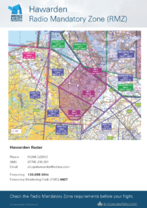
This infringement narrative has been written by the air traffic control team at Hawarden aerodrome which is a key member of the Northwest LAIT.
The Hawarden RMZ is one of two RMZs in the UK and there are four ways in which pilots can enter the notified airspace. It is important to note that the other RMZ (Land’s End) has different ways to gain access (UK AIP EGHC AD 2.22 Paragraph 1 refers).
Background
Due to Hawarden’s location in uncontrolled airspace it was becoming ever more difficult to de-conflict aircraft on Standard Outbound Clearances (SOCs) from the myriad of non-communicating flights permitted to operate in uncontrolled airspace. To maintain the safety of all aircraft, Hawarden ATC is required to avoid conflictions to planned Hawarden departures by delaying an aircraft’s take-off until unknown traffic is no longer an operational issue.
Control of inbound airways traffic to Hawarden Airport is transferred to Hawarden ATC within the protection of Controlled Airspace. However, all Runway 04 final approach paths and several critical areas of the Runway 22 final approach are located in Class G airspace, where Hawarden traffic may come into conflict with unknown, non-communicating aircraft. In cases of such conflict, Hawarden ATC would provide an extended routing to their traffic, which resulted in an increased fuel burn and the associated environmental impact.
Numerous high velocity and heavy aircraft operating at Hawarden Airport made the ‘see and avoid’ principle incompatible with Class G operations. This was particularly important when Airbus A300-600ST ‘Baluga’ was replaced by the Airbus BelugaXL (A330-743L). If the pilots’ intentions could be ascertained, this would increase situational awareness, and allow controllers the ability to plan ahead accordingly.
The Radio Mandatory Zone (RMZ) was introduced in 2017 and would require all aircraft to make and maintain two-way radio contact with Hawarden ATC and advise ATC with pertinent flight details. This would generate a known traffic environment. An RMZ would not permit Hawarden ATC to deviate the route of all traffic to aid deconfliction; it would, however, generate the known traffic environment within which the lower de-confliction minima can be applied (in accordance with UK FIS) and Hawarden traffic could be routed with the confidence that routine unexpected manoeuvres of aircraft do not need to be taken into account.
It was recognised that the establishment may generate some operational restrictions to non-radio equipped aircraft which currently utilise the airspace. To this end, it was necessary to permit some ‘alternative means of compliance’ to be developed which would allow operators to access the airspace, yet still provide Hawarden ATC with a known traffic environment. It was considered that the option of an RMZ provided the most balanced solution with due regard to Hawarden Airport operators and other airspace users.
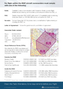
Hawarden RMZ
The RMZ comprises the following three areas:
- Area 1 lies to the north and is located underneath the Manchester Control Area (CTA2); the RMZ here extends from the surface to 2,500 feet AMSL.
- Area 2 is the largest area and lies overhead the Hawarden ATZ and to the south; it extends for the surface to 3,000 feet AMSL.
- Area 3 lies to the south and is located over the western part of Wrexham and over the high ground to the south of Hawarden aerodrome; it extends for the surface to 4,500 feel AMSL.
Above RMZ Areas 2 and 3 are the Class A Pepze CTA-1 and CTA-3 which extend upwards to FL195; the controlling authority for this airspace is Scottish Area Control Centre (callsign Scottish Control on 128.055 MHz)
All three areas are charted on VFR charts with blue semi-circles on the inside of the boundary lines. The Hawarden Radio Mandatory Zone (RMZ) frequency is 120.055 MHz which is also annotated on the charts.
CAA-NATS 1:250,000 Sheet 5 Edition 15 (Central England and Wales)
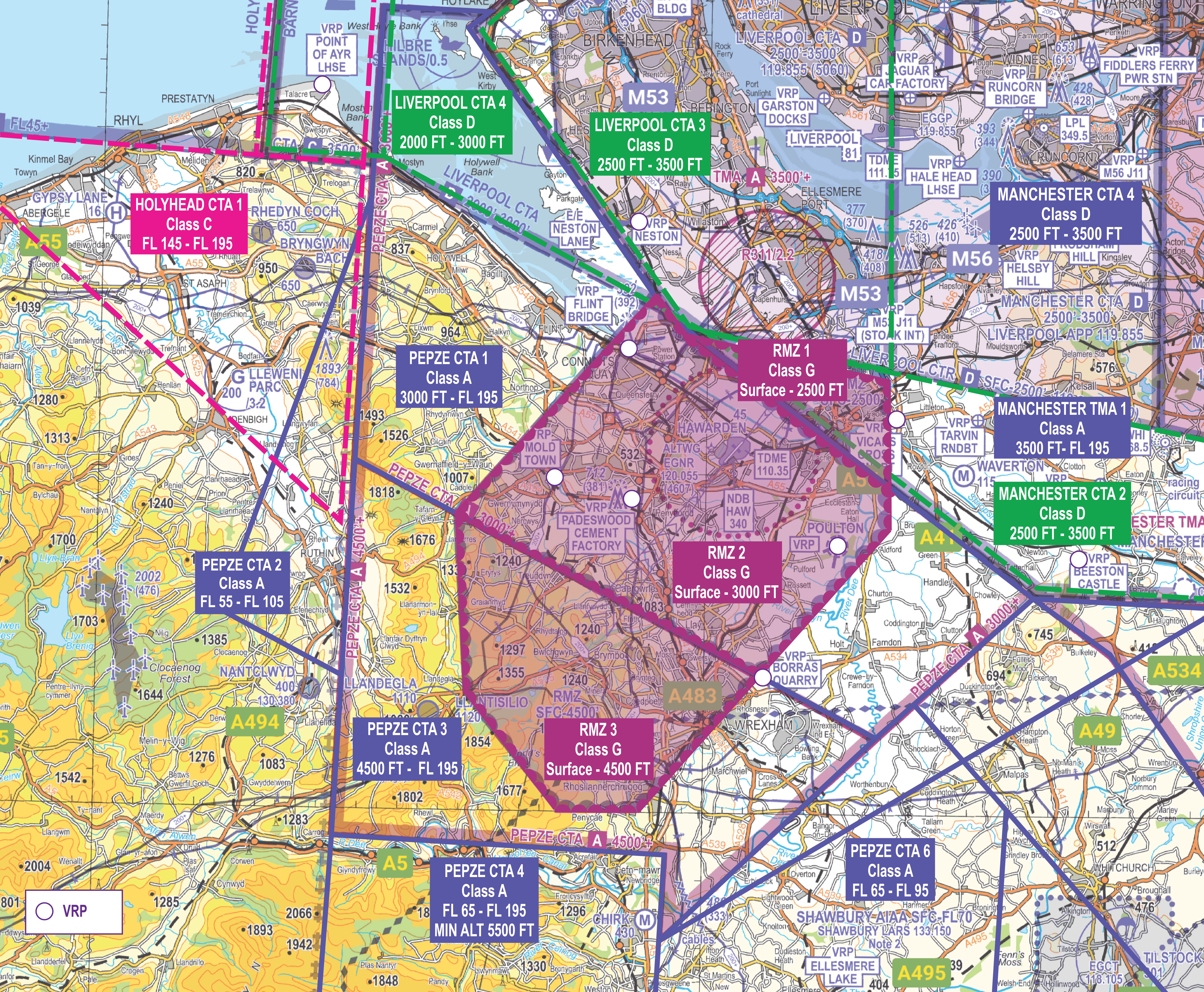
Hawarden RMZ 1, RMZ 2 and RMZ 3
RMZ Procedures
For flights within the RMZ pilots must comply with ONE of the following:
1. Establish 2-way RTF communication with Hawarden Radar (120.055 MHz) passing flight details before entering the RMZ and maintain 2-way communication with Hawarden Radar whilst operating inside the RMZ.
Flight details will comprise:
- Callsign
- Aircraft type
- Position
- Level/altitude
- Intentions of the flight.
2. Display the Hawarden Frequency Monitoring Code (FMC) of 4607 (with Mode C (ALT) if available), whilst monitoring Hawarden Radar on frequency 120.055 MHz prior to entering, and within, the RMZ.
3. Non-radio aircraft should contact Hawarden ATC by telephone (01244 522012), email ([email protected]) or by text message to 07786 208291 prior to commencing any planned flight that will enter or cross the RMZ. The aircraft registration, type, estimates and points of entry/exit, planned altitudes and duration/activity in the RMZ needs to be passed to Hawarden ATC. On receipt of this information an acknowledgement will be issued. This gives you authority to enter the RMZ.
4. Conduct flight in accordance with valid Letter of Agreement with Hawarden ATC if operating from a site within the RMZ.
Hawarden Frequency Monitoring Code (FMC)
The Hawarden FMC (commonly known as a listening squawk) is 4607. It should always be used with Mode C (ALT) if available). It is designed so you can monitor the Hawarden Radar Frequency without contacting ATC; however, you must establish two-way communication with ATC if requested. Observing the transponder code will indicate to Hawarden ATC that you are monitoring the frequency able to be contacted by ATC should the need arise.
Use of the FMC
- Monitor the Hawarden Radar Frequency of 120.055 MHz.
- Select the squawk 4607 (with Mode C (ALT) if available).
- Remember you are not receiving an Air Traffic Service.
- You remain responsible for your own navigation and terrain clearance.
- You are not cleared to enter the ATZ or any Controlled Airspace.
- You do not need to contact Hawarden Radar.
- ATC will call you if they wish to contact you. You will be called in relation to your position.
- When leaving the RMZ, deselect 4607 first and change frequency.
Visual Reference Points (VRPs)
These four VRPs can be useful in identifying the boundaries of the RMZ to assist with frequency change or selection of the FMC. We suggest pilots use the VRPs in the vicinity of Hawarden as a guide to selecting the FMC.
Outside the RMZ
- Beeston Castle lies 5.7NM to the east of the RMZ boundary near the village of Tarporley and to the south of the Shropshire Union Canal).
- Vicars Cross Roundabout lies just to the east of the RMZ Boundary to the east of the city of Chester and on the junction of the A55 and A51.
- Borras Quarry lies on the eastern RMZ boundary and to the north of Wrexham town.
- Point of Ayre Lighthouse lies 11.5NM to the northeast of the RMZ boundary and on the mouth of the River Dee to the east of Prestatyn.
Inside the RMZ there are four further VRPs to aide with maintaining situational awareness and position referencing/reporting:
Inside the RMZ
- Poulton Disused Airfield lies 0.9NM inside the RMZ boundary and to the southeast of Hawarden aerodrome.
- A494/A541 Mold Town Roundabout lies 1.4NM inside the western RMZ boundary.
- Flint Bridge lies 0.5nm inside the RMZ boundary to the northwest of Hawarden aerodrome.
- Padeswood Cement Factory lies 2.85NM inside the RMZ boundary to the southwest of Hawarden aerodorme.
RMZ infringements
Whilst there had been a year-on-year reduction in the number of reported airspace infringements of the RMZ, the numbers remain high and more than doubled to in 2024 to 19.
The major causes of RMZ Infringements appear to be a lack of understanding by pilots of the requirements for entry to an RMZ or a failure to note the area’s depiction on aviation charts. This has been particularly evident in 2024 when many of the occurrences resulted from deviation from the pilot’s initial planned route due to encountering weather along the route. In many cases, the weather conditions could have been predicted by carrying out a detailed meteorology plan using regulated information form the UK Met Office Aviation Briefing website.
Most aircraft that infringe the RMZ tend do so to the southwest of the airspace just below the Pepze CTA, base level 4,500 feet. Pilots, believing that they are routing well to the southwest of Hawarden don’t call Hawarden Radar, but end up transiting through the southwestern portion of the RMZ.
This has a significant impact on aircraft making instrument approaches to Runway 04. The RMZ provides a certain amount of protection from, and predictability for, aircraft transiting nearby. However, due to the high ground in that area radar coverage is poor and unknown traffic quite often appears late on, requiring rapid avoiding action for aircraft at a critical stage of flight, unknown traffic must be de-conflicted by either 5NM horizontally or 3,000 feet vertically. If aircraft call early to transit, co-ordination can be achieved, or inbound aircraft vectored early to pass behind the known traffic.
Guidance card
The Hawarden Radio Mandatory Zone (RMZ) guide includes a summary of the RMZ and details its requirements.
This infringement update has been written by members of the Northwest LAIT at Manchester Airport Air Traffic Service Unit.
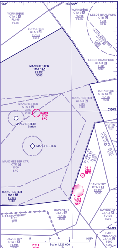
The Class D Manchester CTR extends from the Surface to 3,500 feet AMSL; the Manchester CTA 3 is also Class D with a base of 3,000 feet AMSL and an upper limit of 3,500 feet AMSL. Above both is the Manchester Control Area (TMA) which is Class A airspace. All airspace is based on the Manchester QNH.
Land features and VRPs
The following land features are all outside Manchester CTR and under CTA 3:
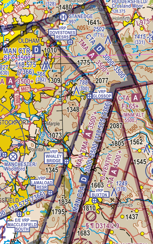
- the VRP at Dovestone Reservoir;
- Chew Reservoir;
- the easterly lakes of Torside Reservoir;
- Kinder Reservoir;
- Combs Reservoir;
- Fernlee Reservoir; and
- Errwood Reservoir.
The VRPs at Glossop, Whaley Bridge and Lamaload Reservoir all lie on the edge or inside the Manchester CTR.
VRPS on the edge of the Manchester CTR
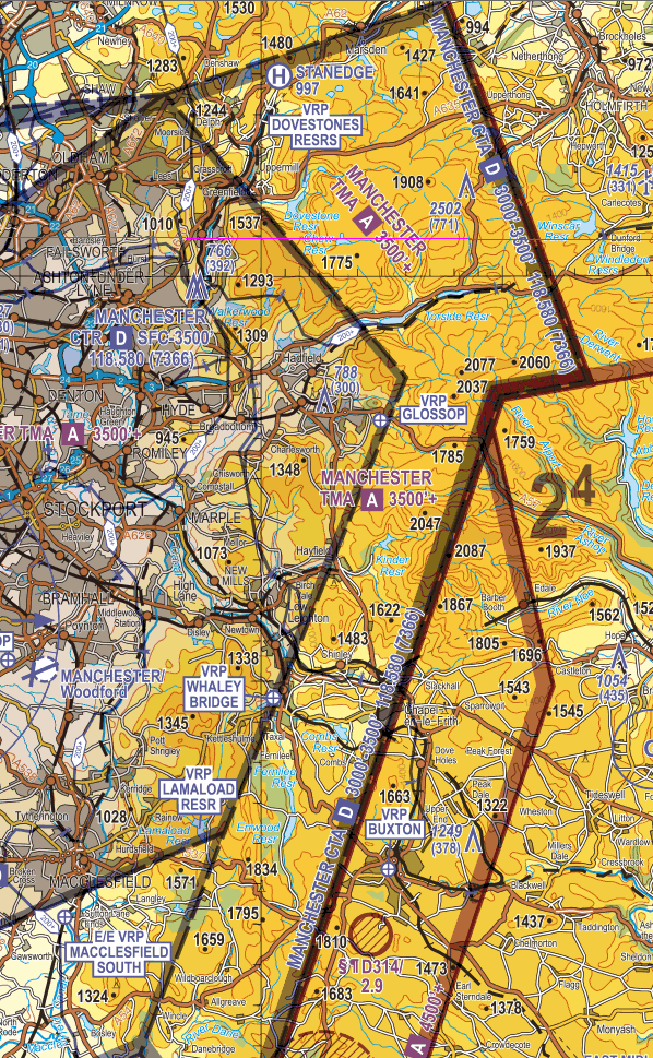
VRPS on the edge of the Manchester CTR
Known hot-spot
A known infringement hotspot is on the west side of the Pennines between Stanedge (a helicopter site marked on the VFR chart) and Whalley Bridge, with the most infringed area around Dovestones Reservoir.
Causal factors
The main causal factors associated with airspace infringements in this area are:
- flying too close to the Manchester CTR to remain to the west of the Pennines;
- flying too close to the base of the Manchester CTA or operating on the RPS and not the Manchester QNH. Since the RPS being the lowest forecast pressure for the entire Barnsley Altimeter Setting Region, when flying on the RPS, pilots will be higher in relation to controlled airspace than they think. Remember: “Wind-on Hectopascals, wind-on height”; and
- operating on the London Flight Information Service frequency rather than Manchester Radar’s frequency. This offers no ability for prompt resolution to a potential airspace infringement. When pilots listen out on Manchester Radar (and squawking 7366), Air Traffic Control has got the opportunity to carry out ‘defensive controlling’ and free-call an aircraft prior to the pilot possibly infringing. In addition, pilots will hear the Manchester QNH being given to IFR inbounds thereby obtaining the correct altimeter setting.
To prevent an airspace infringement
As part of their pre-flight planning and in-flight execution, pilots are strongly encouraged to:
Use a Moving Map and, when able, Take 2.
Use the Manchester FMC. When flying close to controlled airspace, rather than squawking 7000 or obtaining a Basic Service from London Information (which is a non-surveillance unit), use the Frequency Monitoring Code by squawking 7366 and monitoring Manchester Radar on 118.580 MHz. If the aircraft is fitted with Mode S transponder, the Manchester Radar controller will be able to see your callsign on their radar display and will be able to call you if they observe anything untoward. Aircraft should not hesitate to establish contact with Manchester Radar if they require any assistance or are unsure of their position.
Plan. As part of your plan, consider not only the route but forecast and actual weather conditions on the Pennines. This should be done with reference to the regulated meteorological information available on the UK Met Office Aviation Briefing service. This free service includes, but is not limited to, he following regulated information:
- TAFs and METARS;
- Regional Forecasts including GAMETs;
- MetForms 214 and 215;
- Radar and satellite images; and
- Forecast precipitation, pressure, winds and temperature.
Avoid flying on the Regional Pressure Setting (RPS) in the vicinity of Manchester Controlled Airspace. When flying on the RPS, as it is the forecast lowest QNH for a region, you will probably be higher in relation to the Manchester QNH. If you are receiving a FIS from London Flight Information Service, ask the FISO for the relevant QNH rather than remaining on the Barnsley RPS.
Obtain an air traffic service. Know which ATS unit can provide a LARS. To the south of the Manchester controlled airspace it is Shawbury Zone (133.155MHz) and East Midlands Radar (134.180 MHz); to the north it is Warton Radar (129.530 MHz). It is also important to know the relevant operating times and frequency Designated Operational Coverage (DOC) and LARS radius for each ATS unit so that a detailed communications plan can be formulated pre-flight:
- Shawbury Zone – LARS radius – 40NM
- East Midlands Radar – Frequency DOC 60NM/ LARS radius 30NM
- Warton Radar – Frequency DOC 40NM/LARS radius 40NM
Availability of service times can be found in the UK AIP at ENR 1.6 table 4.1.6 and relevant NOTAM.
This infringement update has been written by members of the Northwest LAIT at Air Traffic Control Services Limited (ATCSL) at Liverpool Airport.
Liverpool has historically had its fair share of airspace infringements. Its geographical location on the coast means that to the west it sometimes has pilots ‘hugging the coast’ and infringing the Control Area (CTA) as the base is 2,000 feet AMSL. More often though, the infringements are due to pilots cutting the corners of the northern and southern ends of the North West Transit Corridor and therefore infringing the Northeast and Southeast corners of the Liverpool Control Zone (CTR).
Much work has been done in recent years to try to reduce these infringements, by controllers and pilots coming together at the North West LAIT, discussing the hot spots for infringements (as described above) and providing much-needed focus on the topic. The North West LAIT is well attended by many local flying clubs and schools, whose flying instructors, student pilots and PPL holders are genuinely keen to play their part in keeping the number of infringements of the local airspace to a minimum.
As a result, infringements have indeed reduced. In 2017 there were 34 infringements of Liverpool’s controlled airspace and in 2018 the number fell to 18. For 2019, the figure reduced further to 9. This has largely been attributed to defensive controlling by the Liverpool controllers and the use of Frequency Monitoring Codes (also known as ‘Listening Squawks’) by pilots.
The Liverpool Air Traffic Services Manager, Matt Jackson, explains how defensive controlling works and the benefits of frequency monitoring codes.
“When there are 7000 squawks within a few miles of the edge of controlled airspace, you generally keep an eye on them to see what they’re doing, as much as possible. Sometimes if it’s really busy and you are working lots of traffic you will not be able to give the 7000s much attention, but you will be aware that they are there.
If an aircraft looks as though it is heading towards my airspace I would try calling it to see if it is on my frequency. This is known as defensive controlling, i.e. defending the boundary of your airspace and pro-actively asking pilots heading towards the boundary what their intentions are, before they reach it. This means that a controller will pre-empt a pilot infringing their airspace by contacting the pilot and effectively saying ‘you seem to be heading towards my airspace – would you like a clearance to enter it?’
This is where the Frequency Monitoring Codes, FMCs, are so incredibly useful and I would really encourage all pilots to please use FMCs whenever they possibly can. It definitely helps in these situations.
If the aircraft does not respond to my call and is obviously not on my frequency, this can make things quite difficult. It may enter my airspace, in which case I may need to tactically manage the other traffic in the area, to ensure I avoid it. This may even go to the extent of offering inbound aircraft the off-duty runway, just to avoid the unidentified traffic – which is not an ideal situation.
I may need to speak to neighbouring ATS units to ask whether they know the aircraft’s callsign or whether it is on their frequency, just to try and establish contact with it.
However, if an aircraft is squawking the Liverpool frequency monitoring code 5060 and listening out on my frequency (Liverpool Radar 119.855 MHz), all of this inconvenience and extra hassle goes away! It shows that the pilot has done their homework and has good situational awareness – which is a great start! If I need to call them, they should be listening out on my frequency, ready to respond. I can literally ask them what their plan is.
If they were about to call to ask for a zone entry, I can try to provide them with what they want. If they are just operating near the edge of controlled airspace and don’t want to enter, at least we can have a chat so I can find out what their plan is.
As an example, a scenario that we are faced with frequently is where light aircraft fly between Blackpool and Caernarfon, following the coastline at 2,500 feet. These aircraft will sometimes call Liverpool Radar to ask for a clearance through the CTA at 2,500 feet QNH, which we will try to accommodate if we possibly can. Many aircraft following this route, however, do not call and just blast straight through the airspace!
As it is a known traffic route – especially on a sunny day – Liverpool controllers will be suspicious of any traffic which appears to be following this route but not talking to them. This is where being able to call the aircraft on 119.855 MHz to ask what the pilot’s intentions are is invaluable, offering a clearance through the airspace if that is what the pilot wants.
Defensive controlling if a great way to help pilots avoid airspace infringements, but it will only work if pilots are listening on the right frequency!
It is very different to the opposite – perhaps outdated – way of thinking, which is for a controller to watch a pilot flying towards their controlled airspace and not to say anything, to watch the pilot infringe their airspace, and then tell them they have infringed. This doesn’t really help anyone because it could have been avoided.
Yes, it is always the pilot’s responsibility to not infringe, but if the controller can predict it is about to happen, surely it is better for everyone if the situation is avoided. Please use frequency monitoring codes to help controllers help you not infringe!”
AIC Y111/2022, found on the NATS AIS website, refers to the use of FMC in the UK FIRs. Paragraph 2 explains the methodology of their use. Whilst Liverpool ATSU applies ‘defensive controlling’ exceptionally well, not all ATSUs have the capacity to apply this controlling methodology. However, subject to workload, ATC will often endeavour to provide a timely warning if an aircraft looks like it will infringe but there can be no guarantee that pilots will always be warned if controlling capacity does not permit. Pilots remain responsible for their own navigation and in particular for obtaining permission to enter controlled airspace.
To prevent an airspace infringement, as part of their pre-flight planning and in-flight execution, pilots are strongly encouraged to:
Use a Moving Map and, when able, Take 2.
Plan. As part of your plan, consider not only the route but also the relationship between prominent geographical features and the limits of controlled airspace. As an example, in following the coast from Hoylake to Flint Bridge at 1,800 feet Liverpool QNH (to remain under CTA-4) there are places where being over water the pilot may also be inside the Liverpool CTR or CTA-2.
Avoid flying on the Regional Pressure Setting (RPS) in the vicinity of Liverpool Controlled Airspace. When flying on the RPS, as it is the forecast lowest QNH for a region, you will probably be higher in relation to the Liverpool QNH. If you are receiving a FIS from London Flight Information Service, ask the FISO for the relevant QNH rather than remaining on the Barnsley or Holyhead RPS.
Obtain an air traffic service. Know which ATS unit can provide a LARS. To the south of the Liverpool controlled airspace it is Shawbury Zone (133.155MHz) and to the north it is Warton Radar (129.530 MHz).
Maintain not above 1,500 feet (Manchester or Liverpool QNH) in EG R323 (North West Transit Corridor)). Liverpool cannot vector aircraft east of the eastern edge of EG R323 and, therefore, when required to sequence their inbound traffic one method available is to vector traffic towards the northeast of the Liverpool CTR which sits above the northern portion of the CTR. The Liverpool traffic must be at 2,000 feet to safely pass beneath the Manchester departures whilst aircraft within the North West Transit Corridor can be at 1,500 feet and just 500 feet below.
Therefore, any aircraft initiating an early climb above 1,500 feet before they have left the northern edge of the North West Transit Corridor pose a serious risk to the Liverpool traffic; in addition, there is an increased risk of experiencing wake turbulence issues. When the Liverpool radar controller observes aircraft climbing early and infringing above the northern portion of the North West Transit Corridor, they are unable to take avoiding action by climbing as this will result in confliction with the Manchester departures, instead the only option available is to make an avoiding action turn. With the resultant delay in flight crew initiation compounded by the rate of turns, the potential for a loss of separation event is increased.
The author Mr Matt Jackson, Liverpool Air Traffic Services Manager
North West infringement occurrence reports
Infringement of the Class G Hawarden Radio Mandatory Zone
| Aircraft Category | Fixed-wing SEP |
| Type of Flight | Cross Country Recreational |
| Airspace/Class | London CTR/ Class D |
Met Information
METAR EGNR XX0820Z 17003KT 130V210 9999 SCT022 14/09 Q1023=
METAR EGNR XX0850Z 15005KT 110V180 9999 SCT024 15/09 Q1023=
TAF EGNR XX0625Z XX06/XX15 12006KT 9999 SCT025 BECMG XX13/XX15 30010KT=
TAF EGGP XX0457Z XX06/XX06 09006KT 9999 SCT025 BECMG XX13/XX16 28010KT BECMG XX00/XX03 18004KT=
Aerodrome and airspace
Hawarden Airport is situated in Class G airspace to the southwest of Chester and proximate to the River Dee estuary. The elevation of Hawarden is 45 feet AMSL owing to its proximity to the River Dee estuary, however ground rises to the southwest of Hawarden reaching an elevation of 1,818 feet AMSL in some areas. Immediately north of Hawarden lies the Liverpool CTR and a Restricted Area established to protect Capenhurst. Furthermore, several Class A and Class D CTAs sit above Hawarden and in the immediate vicinity of the aerodrome.
Hawarden Airport primarily serves the onsite Airbus manufacturing plant and has several daily arrivals and departures of the specially adapted Airbus A330 BelugaXL aircraft. Training flights also take place at the airport as well as several charter and private flights. Furthermore, a National Police Air Service helicopter is based at the airport. To facilitate all these flights, Hawarden is serviced by an Air Traffic Control service and has Instrument Approach Procedures to both Runway 22 and Runway 04. In terms of airspace, arriving and departing aircraft are protected by a 2.5NM Aerodrome Traffic Zone (ATZ) and three Radio Mandatory Zones (RMZ) all established from the surface. RMZ-1 is situated to the northeast of the airport and has an upper limit of 2,500 feet AMSL where it meets the base of the Class D Manchester CTA-2. RMZ-2 surrounds most of the area surrounding ATZ to the east, south and west of the airport. The upper limit of RMZ-2 is 3,000 feet AMSL where it meets the base of the Class A Pepze CTA-1. Lastly, RMZ-3 sits to the southwest RMZ-2 and has an upper limit of 4,500 feet AMSL where it meets the base of the Class A Pepze CTA-3.
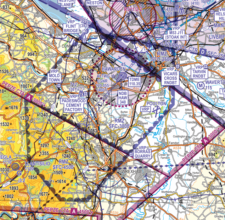
Figure 1: Hawarden ATZ and RMZ-1, RMZ-2, and RMZ-3 as shown on CAA/NATS 1:250,000 Sheet 5 Central England and Wales (Edition 15, 2023).
Air Traffic Control
The Air Traffic Controller observed an aircraft on radar, squawking 7000, 7NM northwest of Hawarden in an orbit. The aircraft was then observed to roll out of the orbit and enter the RMZ in the vicinity of Flint Bridge Visual Reference Point (VRP) tracking south towards Padeswood Cement Factory VRP. The aircraft then turned southwest bound, parallel to the Runway 04 approach track before leaving the RMZ to the southwest. Throughout the infringement, the controller made blind calls to the aircraft however two-way communication was not established until the aircraft had left the RMZ. A service was provided to the aircraft which then routed north. The controller elected to warn the pilot about controlled airspace proximate to them, the Holyhead Control Area (CTA), to avoid any further airspace infringements.
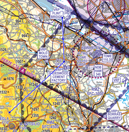
Figure 2: Approximate track of the aircraft through the RMZ represented on the CAA/NATS 1:250,000 Central England and Wales chart (Edition 15, 2023).
RMZ rulesets state that a pilot must establish and maintain two-way communications on the appropriate communications channel prior to entering and when inside the RMZ. Two-way communication is only considered established once the controller has received the following information from the pilot:
- Aircraft callsign
- Aircraft type
- Position
- Level
- Intentions of the flight
At Hawarden, compliance with the RMZ can also be achieved by following one of the alternative means as detailed in UK AIP AD 2 EGNR Hawarden 2.22 Flight Procedures. One of the methods detailed includes monitoring Hawarden Radar on 120.055 MHz and displaying the Frequency Monitoring Code (FMC) 4607 prior to entering and when inside the RMZ.
Pilot
The pilot was on a VFR cross-country recreational flight from Kirkbride to Belle Vue in North Devon, was carrying a CAA NATS 1:250,000 chart and was using a VFR Moving Map application on a tablet. They had planned to track from Kirkbride via Cark, Blackpool, over the west coast towards North Wales before crossing the Bristol Channel towards North Devon. They encountered reasonably good flying conditions with visibility in excess of 10KM and broken cloud with a base of 5,000 feet AMSL until they reached the Liverpool Bay area where the visibility reduced to between 3 and 4 KM, the cloud increased to overcast, and the base lowered to between 900 and 1,200 feet. The pilot had already descended to remain below the Liverpool CTA to the west of Liverpool and therefore had limited scope for a further descent to avoid cloud. They sighted more favourable weather to the south of their position and therefore elected to track towards it while attempting to call Hawarden Radar via radio; however, they were not successful in establishing two-way communication. At this point, the pilot focussed on flying the aircraft to find more suitable meteorological conditions and once they had achieved this, they established two-way communications with Hawarden Radar. Communications were still difficult due to the quality of the radio reception. As the weather had deteriorated below what the pilot had expected they elected to return to Kirkbride.
Findings and Causal/Human Factors
The pilot entered the RMZ when not in compliance with the published ruleset for flight within the airspace after encountering adverse weather along their planned route. It was established that the event was underpinned by lapses in effective pre-flight planning and Threat and Error Management (TEM) particularly in relation to the forecast weather along their route, as well as lapses in management of the flight.
The pilot carried out post-flight analysis and commented on causal factors. As is the case in most aviation occurrences there was not a single cause. Several contributory factors led to how the infringement developed as follows:
Pre-Flight Planning
Route and meteorology planning
The pilot conducted this flight using a VFR Moving Map and a NATS CAA 1:250,000 chart and had appropriately planned for the airspace along their planned This planning included descending to remain below the Liverpool CTAs to the west of the Liverpool in the vicinity of the coast and over the Irish Sea. The pilot had planned to avoid the Hawarden RMZ entirely and track southbound over Wales to the west. They anticipated the weather conditions to be favourable along the route and did not expect to encounter any low cloud or reduced visibility.
It is important to use regulated aeronautical information products from the NATS Aeronautical Information Service during pre-flight planning and preparation such as the most appropriate VFR charts and the UK AIP to ensure the most relevant and accurate information is available. As part of this planning, it is important to ensure that all regulated sources of meteorological forecast materials are consulted and understood prior to the flight so that informed decisions on routing can be made. In the case of this occurrence, the pilot had expected the weather conditions to be favourable and therefore had planned to track over the coast and sea to the west of Liverpool. On the day, the Liverpool and Hawarden TAFs did not indicate low cloud or reduced visibility; however, the UK Met Office has determined that a TAF for an aerodrome is valid for a 5NM radius of that aerodrome and may not include meteorological conditions further out. This can lead pilots into a false sense of security at the planning stages. Furthermore, a TAF and a METAR are limited in scope as to the tops of clouds and will only include a cloud type if it is a cumulonimbus (CB) or towering cumulus (TCU) cloud. However, all cloud types can be hazardous to aviation, and it is essential to reference the Met Forms F215 and GAMET at the planning stages to understand the forecast cloud types tops and how this will affect your flight.
TAF EGGP XX0457Z XX06/XX06 09006KT 9999 SCT025 BECMG XX13/XX16 28010KT BECMG XX00/XX03 18004KT=
TAF EGNR XX0625Z XX06/XX15 12006KT 9999 SCT025 BECMG XX13/XX15 30010KT=
The Met Forms F215 valid at the time of the occurrence had been published on the UK Met Office Aviation Briefing Service at 0300 UTC on the day of the flight. This form showed that the pilot could expect generally good flying conditions however cloud was likely to reduce in height over the sea and coast. Had this form been consulted and understood prior to the flight the pilot could have identified that the route planned was likely to result in less than favourable flight conditions and may have elected to plan a different track further inland or not perform the flight altogether.
Figure 3: Excerpt from the Met Forms F215 Forecast Weather below 10000 FT valid at the time of the occurrence and published at 0300 UTC on the day of the flight. © Crown Copyright 2024
Contingency planning
As the weather forecast included the chance of low cloud it would have been good practice to have a contingency plan. This plan could have included routing further inland and making use of the Manchester Low Level Route (LLR), obtaining a controlled airspace crossing clearance, or diverting to an aerodrome to the north of the Liverpool Bay area such as Blackpool. Furthermore, the likelihood of having to track around the high ground in North Wales meant that there was a possibility of entering the Hawarden RMZ. A good contingency plan would include the conditions required to comply with the RMZ ruleset, such as displaying the Hawarden FMC and monitoring Hawarden Radar.
It is important for every flight to ensure a contingency plan has been made. This can include a plan in case of an aircraft emergency, weather avoidance due to unpredicted weather, passenger sickness etc. Ensuring you have a ‘Plan B’ will reduce the workload of the pilot, increase situational awareness, and reduce the risk of infringing notified airspace. It is advisable to consider the “least restrictive” route as your Plan A. For example, if you wish to cross controlled airspace consider that as your Plan B as it relies on a clearance being issued which may not always be possible. For that reason, tracking outside controlled airspace has already been planned for and is not the “back-up” plan.
Threat and Error Management (TEM)
Confirmation bias
The pilot commented that they had expected the weather to be better and that they decided to continue with their flight which resulted in them infringing notified airspace. Confirmation bias is a regular contributing factor to airspace infringements and in the case of this occurrence the pilot had pressed on into weather which they had not expected to encounter as they believed the conditions would not be as bad as they were observing. The pilot commented that a better course of action would have been to turn around before Liverpool and find an alternative route.
Use of an Air Traffic Service (ATS) or FMC
The pilot was not in receipt of an ATS prior to the infringement and was not required to be; however, an ATS can help to reduce workload in situations such as this. All UK Flight Information Services (FIS) include the passing of meteorological information to pilots when required and in the case of this occurrence the pilot could have obtained a service from Liverpool Radar prior to commencing the water crossing to the northwest of Liverpool. This would have allowed the pilot to request any reported adverse weather conditions from other pilots also in receipt of a service from Liverpool Radar.
Considering the contingency planning discussed in the pre-flight planning section above, the pilot could have also used the Hawarden Frequency Monitoring Code (FMC) when it became apparent that they were required to enter the RMZ. By selecting the FMC and monitoring Hawarden Radar the pilot would have complied with the published ruleset and would have avoided an airspace infringement.
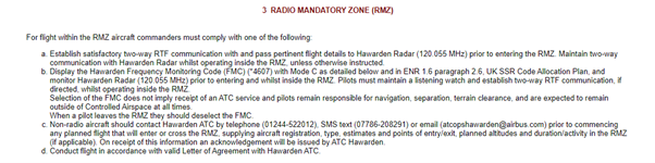
Figure 4: Hawarden RMZ procedures published in the UK AIP. Information correct as of AIRAC 08/2024. This screenshot should not be used for flight planning. You must refer to the most recent AIP entry and any relevant NOTAM prior to flight.
Summary
In conclusion, an infringement occurred when the aircraft entered the RMZ whilst not in compliance with the ruleset published in the UK AIP. The pilot had planned a route which did not enter the Hawarden RMZ; however, they had not appropriately considered all the meteorological information published by the UK Met Office. Had they done so, they would have identified that low cloud was possible over the coast and when they observed this cloud when north of Liverpool it is likely that they would not have flown into the area. A contingency plan had not been considered as the pilot did not expect to experience low cloud along their route therefore the pilot continued over the sea and coast, subsequently tracking southeast, and entering the RMZ. The pilot had attempted to establish two-way communication with Hawarden Radar when to the northwest of the RMZ however had been unsuccessful likely due to their low level and the high terrain in the area. As the situation deteriorated the pilot focussed on flying the aircraft away from the adverse weather before establishing two-way communication with Hawarden Radar.
This occurrence emphasises the importance of accessing and understanding all the published regulated meteorological information from the UK Met Office prior to every flight. By knowing the weather to expect, pilots can formulate an appropriate plan, including contingency routes, and all relevant Air Traffic Service Units along the route. Appropriate planning can also help to break confirmation bias; however, it is important to fly the weather encountered rather than the weather expected. Air Traffic Controllers are there to assist pilots and can provide updated weather information if they have it. TAFs and METARs are useful to plan for weather in the vicinity of aerodromes; however, they have their limitations when it comes to the types and tops of clouds. Furthermore, a TAF may not cover the area along the planned route.
Focus on
- Pre-flight Planning
- Threat and Error Management
- Infringement Avoidance Online Tutorial
- ‘Take 2’ Initiative
- Avoiding Airspace Infringements
- Use of VFR Moving Maps (CAA Safety Sense)
- Meteorology Planning (UK Met Office)
Infringement of Class D – Manchester Control Area
| Aircraft Category | Fixed-wing Microlight |
| Type of Flight | Recreational Flight |
| Airspace / Class | Manchester CTA / Class D |
Air traffic control
The Manchester radar controller was alerted to an aircraft squawking 7365 a few miles to the northeast of Barton aerodrome. The aircraft was indicating an altitude of 2,400 feet (1). The base of the Manchester CTA is 2,000 feet.
Mode S allowed the aircraft to be identified so the controller was able to contact the Barton Flight Information Service Officer (FISO). After a second call to Barton the aircraft descended.
The aircraft was inside controlled airspace for 3 minutes and 36 seconds before leaving the CTA. No other traffic was affected by the infringement.
The Barton FISO explained that the unit is part of an ADS-B (Automatic Dependent Surveillance–Broadcast) trial. This allows a FISO to offer generic traffic information (TI) to pilots operating within the unit’s designated operational coverage (DOC). Manchester Barton’s DOC is notified as 10NM/3,000 feet. Generic traffic information is given using phrases such as “in your vicinity”. The FISO could see that the frequency had not been changed to Warton after the aircraft left the unit’s DOC heading north. So issued TI on traffic that was approaching position from the east (see figure 1).
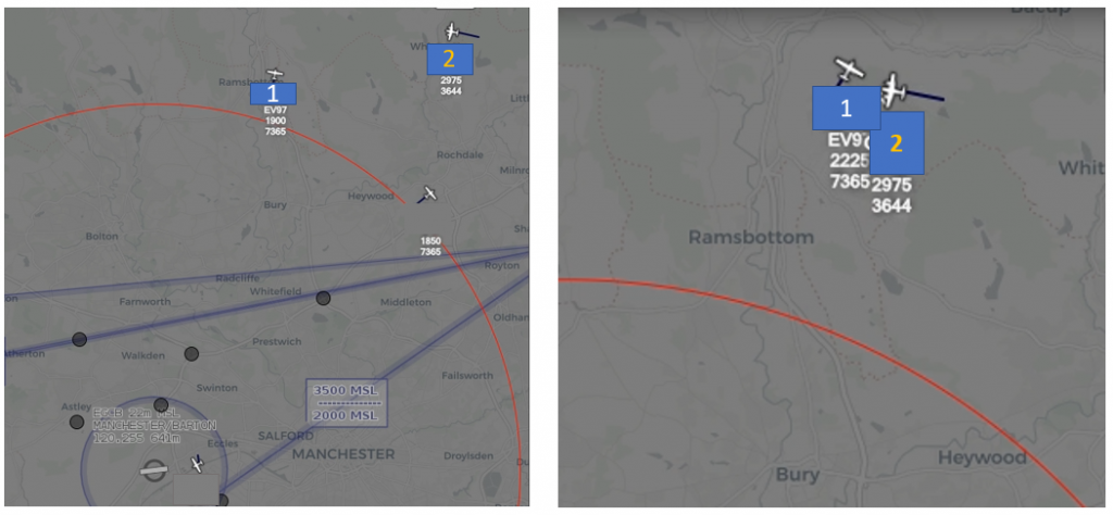
Figure 1: The position of the aircraft is shown as ‘1’ and the approaching traffic as ‘2’
On recovery to Barton, the pilot informed the FISO that they were over Bury (figure 2). The FISO issued TI against an aircraft that was departing the ATZ northbound in a reciprocal direction.
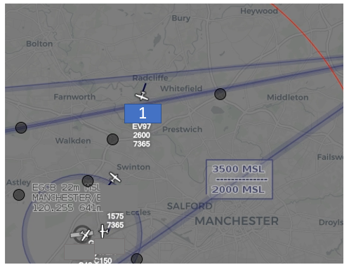
Figure 2: Position of the aircraft over Bury
At that point the aircraft was inside the DOC area, and the FISO commented to their assistant that, based on ADS-B altitude, the aircraft appeared high compared with the reported altitude.
The FISO was about to ask the pilot to confirm their altitude and pass updated information on the opposite traffic when the Manchester radar controller called to let them know the traffic was too high. The pilot was informed and carried out a descent out of the CTA to the correct altitude for an overhead join.
Pilot
The pilot was carrying out a VFR sightseeing flight from Barton to Rawtenstall via Bury and Ramsbottom (figure 3).
On the day of the flight, met conditions were good. Visibility was in excess of 10km with some cloud detected at around 4,000 feet and a light and variable surface wind.
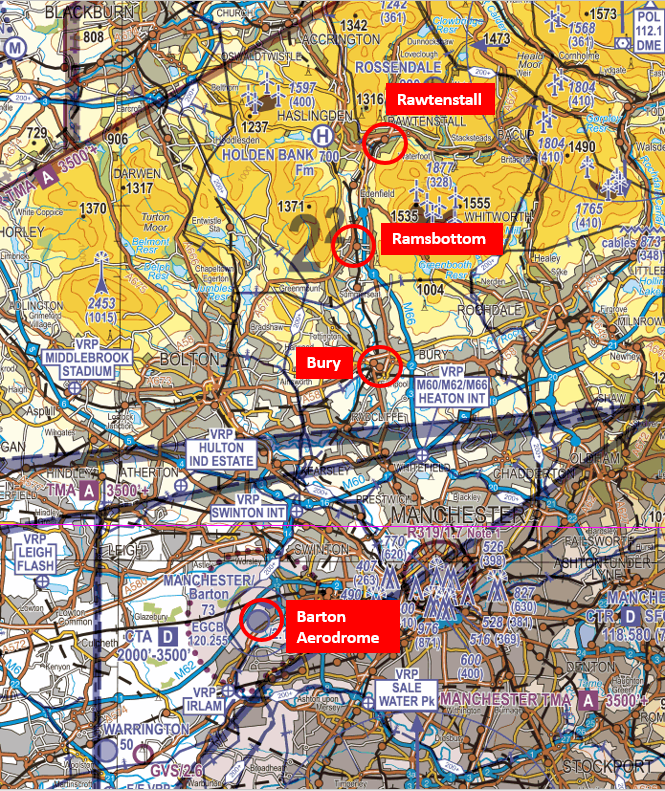
Figure 3: Flight from Barton to Rawtenstall via Bury and Ramsbottom
The pilot usually flew with a fellow pilot to supplement each other’s navigation, lookout and communications. On this occasion they were flying solo as their flying partner was unavailable. The pilot was flying the EV97 for the first time in some months. The pilot was using a 1:250,000 VFR chart and a basic version of a VFR moving map application on their mobile phone. This was secured in a mount on the right-hand side of the instrument panel due to the location of the 12V socket and position of the mount. The pilot explained that mounting a moving map is limited to the right-hand side as nothing can be fixed to the canopy. This meant that altitude information was very difficult to see from the left-hand seat. The aircraft was not equipped with either strobes or a beacon and, due to its bare aluminium colour, the pilot was aware that it was harder to see air-to-air than white microlights. The pilot remained on the Barton frequency throughout the flight and was in receipt of a Basic Service from Barton Information.
On the outbound leg, the FISO issued a warning of a much faster aircraft heading in a reciprocal direction. The microlight pilot became extremely anxious that the pilot of the conflicting aircraft would not become visual and all their focus turned to lookout, scanning all around in an unsuccessful attempt to catch sight of the aircraft. Although trimmed for level flight, the microlight had started a gradual climb from Bury to reach an altitude of 2,700 feet at Rawtenstall. Due to their focus on scanning, the pilot had not realised that the aircraft had climbed approximately 1,000 feet above their intended cruising altitude. On turning back towards Barton, and not realising they had climbed so much, a quick glance at the altimeter told the pilot that the aircraft was at *,800 feet. Having intended to fly at around 1,700 feet, the pilot mistakenly took this reading to be 1,800 feet. It was really 2,800 feet. The pilot started a gradually descent of 300 feet to what they thought was 1,500 feet, but was actually 2,500ft. This altitude was maintained the rest of the way back to the Barton overhead.
The pilot made two position reports en-route at this altitude of “Overhead Bury, one thousand five hundred feet” and “Half a mile north of Swinton Interchange at one thousand five hundred feet”. Overhead Barton, the FISO asked the pilot to check their altitude at which point they realised that the needle on the altimeter was pointing towards “2” not “1”. The pilot apologised whilst commencing a steep descent into the Barton circuit. The pilot added that a smaller aircraft or one with less performance in their proximity, “as often happens around Barton”, would not have caused them so much concern. But the warning of a larger aircraft travelling at a much higher speed triggered a serious worry about the risk of a mid-air collision had affected their concentration.
Figure 4 shows an approximate representation of the flight profile.
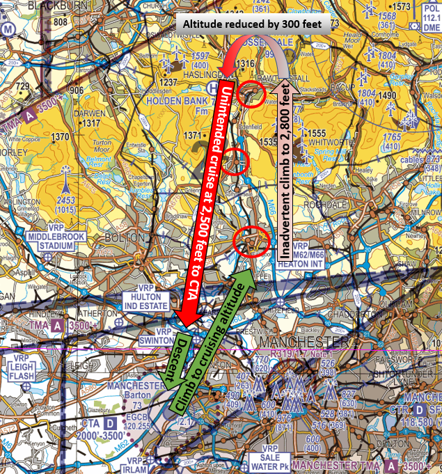
Figure 4: Approximate representation of the flight profile.
After the event the pilot analysed the occurrence, and noted a number of factors that led to them not noticing the higher altitude:
- Better conspicuity would lessen the stress of not being seen by other aircraft thereby reducing their focus on external scan and allowing some division of attention between lookout and instrumentation.
- A check of the basic version of the VFR moving map technology led them to note that their version did not offer warnings of possible vertical infringements.
- The mobile phone was positioned so far away from the pilot that they could not get an independent altitude check from that equipment.
- In previously flown aircraft, they recall seeing an additional display within the altimeter showing the altitude in numbers.
Causal factors
The pilot had planned to carry out a sightseeing flight to the north of Barton. The decision to use a 1:250,000 chart, allowing greater definition of the route features, was good based on the aircraft’s speed and the relatively short distance of the flight (approximately 15NM from Barton aerodrome). The use of a chart for navigation was supported by a VFR moving map.
However, in becoming distracted in trying to visually acquire conflicting traffic, an inadvertent climb resulted in the aircraft eventually reaching 1,200 feet higher than the intended cruising altitude.
The pilot was subject to confirmation bias. They knew they wanted to fly at or around 1,500 feet and the small needle on the altimeter pointed to 800 feet. In the pilots mind they expected to be at or around 800 feet. Having not flown the EV97 solo for some time, they were not surprised to have reached a slightly higher altitude by a few hundred feet.
Nothing in their plan or the small needle on the altimeter was to indicate that they were over 1,000 feet higher than intended. The confirmation bias could have been broken by one, or both of the following:
- The pilot normally flew with another pilot who has a tablet device with a ‘full’ version of a VFR moving map application. Had the pilot has such a device/version, even as a back-up to their using the 1:250,000 VFR chart, they would have had the benefit of a larger display which would have provided them with alerts as they climbed up to 2,800 feet with the Manchester TMA being above them at 3,500 feet. It would also have provided an alert on the inbound leg as they approached the Manchester CTA some 300 feet above the base altitude and then again as the CTA base stepped down to 2,000 feet.
These warnings are shown when the trajectory, both horizontal and vertical, would take an aircraft into a volume of airspace. An onscreen warning is often accompanied by an audible alert, the form of which depends on the type of airspace, and a thick border may be drawn on the map accompanied by large coloured arrows to highlight which piece of airspace is associated with the warning.
The CAA and safety partners actively encourage all pilots to incorporate the use of moving maps in both pre-flight planning and during flight. On this occasion, the pilot had not applied active Threat and Error Management in relation to their equipment in respect of the size and position of the display and the functionality of the ‘basic’ version of the application. In addition, the lack of options for the position of the mount may have played a part in accessing data from the moving map. - Had the pilot elected to obtain an air traffic service from the local LARS unit at Warton on 129.530MHz the chain of events may have been broken. On initial contact the pilot may have noticed the error when passing their details to the controller or, when they told Warton Radar that they were at 1,800 feet, Warton Radar would have noted an error in the Mode C when carrying out the verification and validation process during identification for a radar service. The Barton DOC is notified as 10NM/3,000 feet. When leaving the DOC area northbound, the pilot would have been better served getting a service from Warton.
The pilot became task saturated. While trying to visually acquire the aircraft for which they received information they failed to note an inadvertent altitude change. The pilot cannot be criticised for being risk aware and concerned of the developing situation. However, the use of an electronic conspicuity device on a larger display and/or the provision of an air traffic service are effective mitigations of mid-air collision. With mitigations in place capacity can be increased and stress levels reduced.
Having operated the EV97 for some time some skill fade may also have been a contributory factor.
Post-flight analysis
The pilot is commended for carrying out such detailed post-flight analysis of the occurrence (including the submission of a detailed and honest report), their approach to the factors surrounding the occurrence and for following Just Culture principles.
In addition they immediately engaged the services of a flight instructor to obtain remedial refresher training to ensure that issues could be addressed and rectified.
Focus on
- Use of Moving Maps
- Threat and Error Management – Read Threat & Error Management
- Confirmation Bias – Read SKYbrary Confirmation Bias
- Provision of an Air Traffic Service – Read Lower Airspace Radar Service (LARS)
- Use of Frequency Monitoring Codes – Read Frequency Monitoring Codes (Listening Squawks)
(1) Please note that Mode A code and Mode C pressure-altitude have not been verified.
Other narratives in this series can be found on the Infringement occurrences page.