Infringement of the Class D Farnborough Control Area 1 (CTA-1)
| Aircraft Category | Fixed-wing SEP |
| Type of Flight | Cross Country Recreational |
| Airspace/Class | Farnborough CTA / Class D |
Met Information
METAR EGLF Z XX1020Z 04013G24KT 360V060 9999 SCT022 06/M01 Q1025
METAR EGLF XX1050Z 06014KT 9999 SCT026 06/M01 Q1025
Air Traffic Control
The Air Traffic Controller reported operating as Farnborough West and Farnborough Zone band-boxed in busy traffic. The aircraft had been handed over from Farnborough LARS North requesting a Farnborough controlled airspace transit. The aircraft was asked to squawk Mode A 0460 (for Zone) and placed under a Basic Service. A transit clearance was issued routing Southwest of the Bagshot Mast to the Ockham VOR/DME (OCK), not above altitude 2,000 feet, VFR, remaining outside the London Control Zone (CTR). This was read back correctly after being challenged for an omission from the clearance in the initial read back.
Whilst monitoring the track of the aircraft, the service was changed from a Basic Service to a Radar Control Service as the aircraft entered LF CTR-1 southwest of the Bagshot Mast and then back to a Basic Service as the aircraft vacated the Farnborough CTR-2 in the vicinity of Woking. The aircraft requested to route via OCK after leaving Farnborough CTR-2 and was advised that they could resume their own navigation.
Whilst the aircraft was maintaining 1,900 feet beneath CTA-1 (base of 2,000 feet AMSL), the controller instructed the pilot to reset squawk 0435 (for LARS). The controller was imminently to issue advice that the aircraft was operating at the base of controlled airspace, as the aircraft’s altitude was observed to climb to 2,100 feet, which triggered an Airspace Infringement Warning (AIW) alert. The controller informed the pilot that they had entered controlled airspace and instructed them to descend to be not above 2,000 feet to remain outside. The pilot apologised and the aircraft was then observed to descend to leave controlled airspace.
Note: The Ockham VOR is no longer certified for en-route navigation. While its DME has a designated operational coverage (DOC) of 70NM, the VOR component is retained solely for terminal and approach procedures at select airports, including Heathrow.
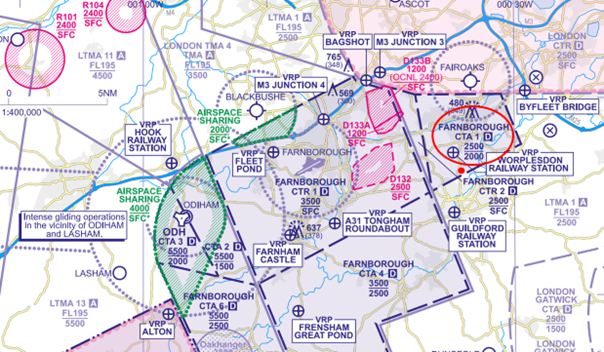
Figure 1: The aircraft entered the Class D CTA-1 indicating 2,100 feet where the base of controlled airspace is 2,000 feet AMSL.
Pilot
The pilot reported that they had planned to fly a route anticlockwise round the London CTR. The route had been planned on a VFR Moving Map as follows:
Bovingdon VOR/DME (BNN) – Woodley NDB (WOD) – Farnborough Airport (EGLF) Zone Transit – OCK
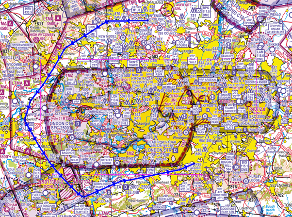
Figure 2: Route flown represented on the CAA/NATS 1:500,000 South – Ed.51
The pilot reported that a zone transit was sought through Farnborough’s CTR and granted not above 2,000 feet to the west of Bagshot mast. Once outside controlled airspace, approval was given to take up their own navigation direct OCK under a Basic Service. During this phase the pilot was advised they had climbed into controlled airspace, at which time they apologised and immediately descended. The pilot reports that from their VFR Moving Map log, it would suggest they had entered controlled airspace for approximately 2 minutes. The pilot stated that they encountered significant thermal activity when proceeding direct OCK necessitating power changes and inputs to maintain a constant altitude from time to time during the flight.
In discussion with the pilot post event
The pilot explained that this cross-country flight was conducted to maintain their currency and prevent skill fade. The pilot further explained that flying this route, around controlled airspace, was intended to not only help to maintain their flying skills but also allowed them to check that the aircraft’s avionics worked as expected.
In the lead up to the infringement, the pilot stated they were tracking direct OCK. It was at this time they experienced significant tail-lift pushing them up to 2,100 feet and thus infringing the Farnborough CTA-1. The pilot confirmed they were not using the aircraft’s autopilot. They further explained that it was whilst transiting initially beneath the CTA-1, they were tuning in to the Ockham VOR/DME.
The pilot expressed they wanted to remain as high as possible at all times whilst operating outside of controlled airspace in order to provide time to troubleshoot and perform a forced landing if necessary. Their rationale was based on having previously experienced 3 partial power losses. As a result, they had become normalised to fly at a higher altitude wherever possible. The pilot explained that they found cockpit workload inevitably increased when flying around the London CTR due to the extent of controlled airspace and ‘choke points’ around the area.
Findings/Causal Factors
The infringement occurred due to an inadvertent climb into the CTA when planning to fly 100 feet below the vase of controlled airspace due to thermic activity and possibly compounded by distraction when setting their VOR equipment. Whilst the pilot reacted quickly to the climb, the response was insufficient to prevent the aircraft entering controlled airspace as the aircraft was operated just below the base. However, a number of valuable lessons emerged from this occurrence which may be relevant to us all as pilots.
It was established that the event was underpinned by lapses in pre-flight planning, Threat and Error Management (TEM) and management of the flight.
The pilot is to be commended for their openness and post-occurrence actions. The pilot carried out post-flight analysis and commented on causal factors. As is the case in most occurrences there was not a single cause, several contributory factors led to how the infringement developed.
Pre-Flight Planning
Route planning
The pilot elected to fly 100 feet below the base of controlled airspace in thermic/turbulent conditions. Pilots are advised to maintain adequate separation from notified airspace through the application of the ‘Take 2’ guidance (where able, plan to remain at least 2NM from the edge or 200 feet below the base of the subject airspace) to avoid airspace infringements. The ‘Take 2’ initiative is neither a buffer based on State policy, nor is its application mandatory; it is merely guidance based on the principle of good airmanship, introduced by pilots to help their fellow pilots and other airspace users. If following this guidance places the pilot in an uncomfortable position, this is a threat, and should be addressed during the pre-flight planning stage, with potentially a less restrictive route decided upon.
Meteorology Planning
The pilot reported they encountered significant thermal activity when proceeding direct OCK necessitating power changes and inputs to maintain a constant altitude from time to time during the flight.
A thorough weather brief using regulated information from the Met Office Aviation Briefing Service website, for example Met Forms F214 and F215, should be completed prior to every flight and associated risks incorporated into the planned route. Local conditions can vary from what is forecast, reinforcing the advice to maintain adequate separation from notified airspace through the application of the ‘Take 2’ guidance. The recommended 200 feet distance may need to be increased during flights where turbulence or thermic conditions are encountered to prevent inadvertent climbs into controlled airspace.
Threat and Error Management (TEM)
Distraction
The pilot explained that whilst transiting beneath CTA-1, they were tuning in to the Ockham VOR/DME. Although it cannot be ascertained to what extent tuning into the VOR contributed to the infringement, operating proximate to controlled airspace and having just completed a zone transit and now prompted to reset the squawk, the pilot could have become task saturated. By not following the ‘Take 2’ guidance would further have reduced the pilot’s ability to remain below controlled airspace. In this instance, applying the ‘Aviate, Navigate, Communicate’ principle would have allowed the pilot to maintain their altitude relative to the base of controlled airspace. Thorough pre-flight planning would enable this threat to be identified, and the pilot could have planned to tune into the Ockham VOR/DME at a time where cockpit workload was low (prior to the Farnborough CTR transit).
VFR Moving Map
The pilot was using a VFR Moving Map application; however, it could not be ascertained what alerts were present, if any, and the response to them. When configured correctly VFR Moving Maps can not only enhance a pilot’s situational awareness in flight, but they can help to reduce confirmation bias and can also offer timely alerts to airspace and aviation hazards. Operating around controlled airspace will alert the pilot to controlled airspace proximate to their position (if configured correctly); however, there is a human factors element present whereby the pilot intuitively accepts/cancels the alert without having fully assimilated the information given. This can be especially true in cases where pilots are familiar with the airspace or are subjected to constant multiple alerts leading to ‘alert fatigue’. Every flight, even along routes previously flown, should be thoroughly planned, addressing the potential threats and errors for each phase of flight.
The CAA actively encourages pilots to use VFR Moving Maps in conjunction with the CAA/NATS Chart. However, VFR Moving Maps are not regulated by the CAA, and it is important to understand their limitations including differing depictions and altitude inaccuracies. They should not be used as your sole means of planning and navigation and a backup should be carried to prevent a loss of situational awareness should your device malfunction.
Summary
In conclusion, Human factors play a major role in many airspace infringements and in this case, the desire to remain as high as possible when flying outside of controlled airspace and distraction, resulted in the pilot inadvertently climbing into controlled airspace after the significant thermic conditions encountered. The pilot carried out effective post flight analysis and was open and honest about the occurrence in line with Just Culture.
Focus on
- Threat & Error Management
- Pre-flight Planning and Preparation
- Distraction and Interruption (CAA Safety Sense)
- Meteorology Planning (UK Met Office)
- VFR Moving Maps (CAA Safety Sense)
- ‘Take 2’ Initiative
Infringement of Class D airspace – Birmingham Control Area 1
| Aircraft Category | Fixed-wing Aeroplane |
| Type of Flight | Recreational Flight |
| Airspace/Class | Birmingham CTA-1 / Class D |
The Air Traffic Controller
The Air Traffic Controller reported that Runway 33 was in use at Birmingham with one aircraft shortly to depart. The controller was alerted to an unknown aircraft entering CTA-1 indicating 1,900 feet and squawking 0010 (the Birmingham Frequency Monitoring Code). Using MODE S derived information, the controller made a transmission to the pilot and asked them to descend immediately. The departing aircraft was instructed to depart straight ahead to maintain separation to the west of the infringing aircraft. The pilot stated they were mistakenly inside the CTA and descended; the aircraft was identified, issued with a discrete squawk and, once clear of the CTA, offered a Basic Service. Sometime later the aircraft climbed again into the CTA to 1,600 feet and, when informed of the climb, the pilot carried out an immediate descent.
The Pilot
The pilot was prompt to submit a comprehensive report to the CAA. They reported that the aircraft had recently had a complete avionics refit with all original radios and navigation equipment replaced with fully integrated GPS/NAV/COM/MFD equipment, Electronic Flight Instruments and an autopilot. Initial flights post-installation were carried out for the pilot to become familiar with the basic instrumentation; the subject flight was planned for a longer distance to test the autopilot. The pilot openly admitted that the new avionics were not the reason for the infringement but “sloppy planning” carried out on the morning of the flight was a contributory factor. In that planning session, the pilot had ‘rubber banded’ the magenta line on the Moving Map. The red line in Figure 1 shows the route planned and that flown. Having taken the northern route around Birmingham many times, after departure the pilot usually routed at 1,900 feet to Lichfield Disused, then west between Cosford and Wolverhampton Aerodrome Traffic Zones taking them below the Birmingham CTA-3 with a base of 3,500 feet (blue line in Figure 1).
On the day of the infringement, the pilot followed their plan that took them west through, and not below, the similarly shaped but lower CTA-1 which has a base of 1,500 feet. On hearing their callsign broadcast by the Birmingham air traffic controller, the pilot’s first instinct was to disengage the autopilot and follow the requests of the controller. They then accepted a basic service and a discrete squawk. The second climb was thought to have occurred as the pilot wouldn’t normally fly as low as 1,500 feet over the built up areas to the west of Aldridge towards Walsall; they reported that they were most likely conscious of a lack of clearance with the terrain which, in that area, lies between 450 feet and 500 feet amsl. The rest of this flight, and the return flight home was uneventful.
The pilot added that on any other day they were sure they would have noticed the mistake of their plan in the air because the route was clearly wrong. However, distraction caused by focussing on the new avionics drawing more of their attention led them to miss the planning error.
After the occurrence, the pilot elected to take time with an instructor who was familiar with the new avionics to carry out some more familiarisation training and navigation practise.
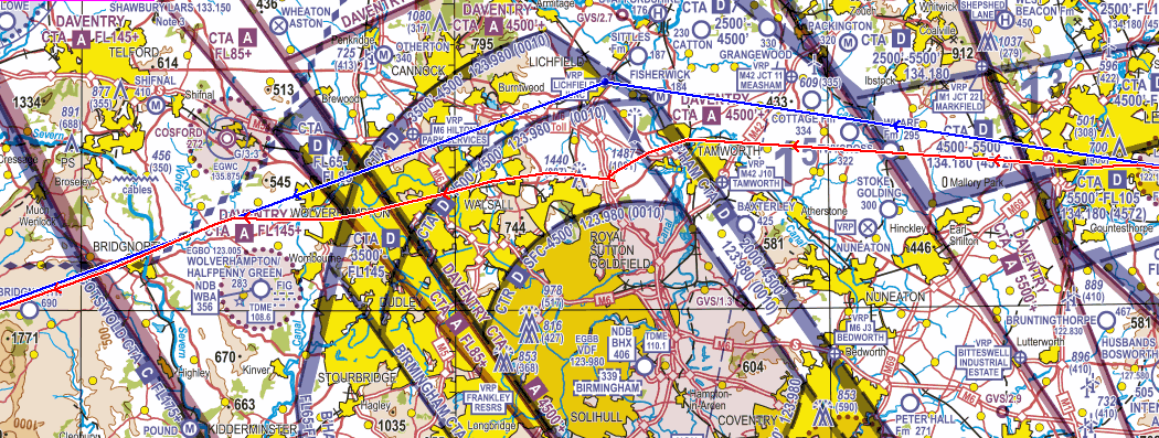
Figure 1
Causal Factors/Findings
The pilot is to be commended by their openness and post-occurrence actions. This occurrence demonstrated the benefit of using a Frequency Monitoring Code (FMC); the pilot reported that they use them whenever they are available in the areas in which they are flying. This positive approach to, and correct use of, the FMC allowed the initial infringement to be resolved promptly by the controller and pilot. In addition, the pilot correctly operated their transponder with MODE C (ALT) alerting the controller to the infringement; had MODE C not been operated, the controller would have been correct to have ‘deemed’ the aircraft to be below the CTA. Had that been the case, the risk of a mid-air collision or the infringing aircraft being affected by wake turbulence would have been heightened.
Poor planning and a failure to double check the route and associate altitudes of the airspace resulted in confirmation bias that they were able to fly at 1,900 feet. In the planning phase, by creating a back-up on a paper chart, you are often notice additional information/details that you don’t always notice on your Moving Map display.
Even though the pilot was flying with a Moving Map, it is not known why there was no response to the alert. It is possible that the confirmation bias led the pilot to dismiss the alert without noting its subject. When properly configured and used, an airspace warning would have been given the pilot a timely alert of their proximity to controlled airspace.
In summary, the pilot did not carry out sufficiently detailed pre-flight planning which, combined with confirmation bias and distraction from overly focussing on new avionics, resulted in their flying into Class D controlled airspace without an air traffic control clearance. However, textbook use of an FMC allowed the infringement to be resolved in a prompt manner.
Despite some errors associated with Human Factors, the pilot has embraced a Just Culture and identified the benefits associated with completing the appropriate refresher training which was carried out with a Flight Instructor.
Focus on
- Pre-flight planning and preparation
- Human Factors and confirmation bias
- Use of Moving Maps
- Threat & Error Management
- Provision of an Air Traffic Service: Lower Airspace Radar Service (LARS)
Infringement of Class D airspace – Stansted Control Area 4 and Luton Control Area 1
| Aircraft Category | Fixed-wing Aeroplane |
| Type of Flight | Recreational Flight |
| Airspace/Class | Stansted & Luton CTA / Class D |
The Air Traffic Controller
The Air Traffic Controller reported that they had traffic on a right-base for Runway 25 at London Luton Airport descending to 3,000 feet. A radar contact was seen to climb into controlled airspace south of Royston passing 2,600 feet before stopping the climb at 3,000 feet on an approximate track of 250o. Traffic information was passed to the Luton arrival aircraft and it was turned onto a shorter final to avoid the infringing aircraft. At this point the unknown aircraft selected 0013 squawk and the controller was able to ascertain their callsign and get 2-way communication with him. The pilot informed the controller they were leaving controlled airspace to the north which they subsequently did. The aircraft was then identified and given a service as per the pilot’s request. The Luton arrival was then re-vectored and completed a safe approach to land.
The Pilot
The pilot reported carrying out a recreational flight from Duxford to Cornwall via Wing (west southwest of Leighton Buzzard) to route to the north of the Luton Control Zone. The route was planned to be flown at 3,000 feet to remain below the CTAs with a lowest base of 3,500 feet. The plan was to climb straight ahead to 3,000 feet on a heading of 251o after departure from Runway 24 (Figure 1).
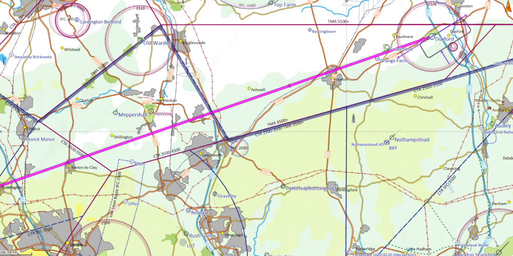
Figure 1
On the morning of the flight there was a strong northerly wind flow down the east side of the UK. The associated TAF were as follows:
- Stansted: 300/14, PROB 40 TEMPO 2606/2609 32018G28
- Luton: 300/14, TEMPO 2606/2706 33018G28.
- The forecast 2,000 feet wind at 5230N 00E was 340/35 (35 knots at 90o to the planned track)
Just before departure an aircraft called Duxford Information to state they would be conducting visual circuits at Fowlmere (2.5NM west southwest of Duxford). On lining up for departure the pilot was informed of the traffic at Fowlmere and the surface wind “being something like 310/16”.
On climb out the pilot encountered the most vigorous turbulence that they could recall flying in for many years. They elected to hold runway heading as best they could to climb straight ahead out of the ATZ without turning right to the track of 251o degrees to enable them to remain clear of Fowlmere (blue line in Figure 2); the passenger was asked to look out for the Fowlmere circuit traffic. Given the turbulence, the pilot elected to climb at best rate of climb speed, which was approximately 80 knots, with the aim of getting into smoother air as soon as possible.
Once clear of Fowlmere, the pilot called Duxford to leave their frequency, changed to Luton Radar on 129.550 MHz and then selected the Luton Frequency Monitoring Code (FMC) of 0013. With the long nose of the aircraft, forward visibility is limited when climbing steeply; unfortunately, that meant fewer visual cues as to actual track were available to the pilot. As the aircraft approached 3,000 feet the pilot asked the passenger to pass them their Moving Map tablet that had been running since departure. The pilot was just noting they had had flown to the left of the airspace line (magenta line in Figure 2) when Luton Radar called to advise that they were indicating at 2,800 feet and was advised immediate descent to below 2,500 feet. Realising their error, the pilot responded that they were descending and turning north to head out of the Stansted CTA as quickly as possible.
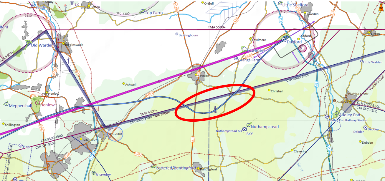
Figure 2
ATC aspect
The airspace and track where the aircraft infringed is routinely used by Luton and Stansted traffic. This incident took place when the traffic was light and therefore the consequences of the infringement was minimal. Following agreement with the pilot of the arriving aircraft the controller re-positioned the aircraft and ensured minimum separation was achieved between the two aircraft However, in normal traffic levels with a continuous stream of arrivals the ability to reposition the aircraft without any impact on subsequent arrivals is unlikely. The workload increase for pilot and controller is significant under these circumstances with safety remaining paramount. One infringement of only a few minutes can result in many minutes of delay to operators, with additional fuel burn and emission also a consideration.
Causal Factors/Findings
The pilot carried out detailed and effective planning in route selection to remain outside controlled airspace and included the use of FMC along the route. In addition, they were equipped with a Moving Map which was intended to be used actively en-route. They also recognised the Threat associated with dual operations at Duxford/Fowlmere.
However, a minor change to the plan moments prior to departure allowed the introduction of lapses in wider Threat and Error Management. The decision to fly further south in strong cross winds and to climb at a higher rate resulted in the aircraft’s track being affected greater over a shorter distance the aircraft drifting further south of track than had been anticipated. The pilot, unaware of their ground track due to reduced forward visibility associated with the aircraft’s attitude then lost situational awareness and extended beyond that required to avoid the traffic flying circuits to the north of Fowlmere. By the time the aircraft was south abeam the Runway 25 threshold at Fowlmere, it was 1.2NM south and passing 1,500 feet. In addition, had the pilot identified that routing to the south of Fowlmere would take them closer to the Class D CTAs they may have identified the increased value to using the Moving Map. This would have enabled them to regain situational awareness lost through the aircraft’s attitude. The pilot could have either turned right back onto track or stop their climb below 2,500 feet to remain below the CTA. However, the pilot was faced with several distracting factors from their original plan and their capacity was rapidly being used in handling the aircraft in extremely turbulent conditions whilst considering the traffic at Fowlmere and the wellbeing of their passenger.
In their wider plan, the pilot had considered the Take 2 aspect to remain clear of controlled airspace but that was not revised following the amended plan to deviate to the south of Fowlmere and thereby fly close to the CTA. Had the pilot only climbed to, for example 2,300 feet, until closer to Royston, the infringement could also have been avoided. This probably did not enter the pilots thought process as the focus was on climbing out of the turbulence, avoiding the Fowlmere visual circuit, and selecting the next radio frequency and FMC.
Notwithstanding the lapses in Threat and Error Management, the pilot’s initial plan was good and incorporated several key measures to prevent airspace Infringements:
- Comprehensive planning including airspace avoidance and meteorology;
- Use of a Moving Map; and
- Use of an FMC.
That decision to use an FMC enabled early intervention by air traffic control to assist the pilot and resolve the situation promptly. In addition, detailed post-occurrence analysis and open and detailed reporting by the pilot enabled lessons to be identified to avoid a recurrence.
Focus on
- Pre-flight planning and preparation
- Human Factors
- Use of Moving Maps
- Threat & Error Management
- Frequency Monitoring Codes (Listening Squawks)
Infringement of Class A airspace – Cotswold Control Area
| Aircraft Category | Fixed-wing Microlight |
| Type of Flight | Instructional Flight |
| Airspace/Class | Cotswold CTA / Class A |
Met information
At the time of the infringement the local QNH both at Brize Norton and Fairford was 1003 hPa. The cloud was BKN (5-7 oktas) at 4,800 feet and the forecast 5,000 feet wind on the UK Low-level Spot Wind Chart (Form 214) was 190/30.
The Air Traffic Controller
The Air Traffic Controller reported observing an unknown aircraft squawking 7000 indicating FL071 (7,100 feet based on 1013 hPa) enter the lateral confines of L9 in the vicinity of the IFR reporting point GAVGO, which is near Swindon. The aircraft remained in L9 for a period of 9 minutes 32 seconds. The aircraft was later observed to change to a Brize Norton conspicuity squawk (3737) but the Brize Norton Air Traffic Service Unit was unable to establish contact with the pilot.
The Pilot
The pilot reported that the training flight was being conducted in very local and familiar airspace. Navigation was being carried out using a 1:250K VFR chart with no GPS/Moving Map. The initial part of the flight was conducted under a layer of cloud (reported to be at 4000-5000 feet) but training was made difficult due to turbulence. The aircraft was turned south to remain clear of the Cotswold CTA with a base of FL065 and climbed above the cloud. Due to strong winds aloft, the aircraft was not positioned as far south an anticipated and with repeated turns the aircraft was ‘blown back’ into L9. The pilot found it difficult to determining their position due to only intermittent sight of the surface as a result of operating above cloud; they felt that the infringement was increased due to the low QNH.
Causal Factors/Findings
1:250,000 VFR charts have a vertical limit of airspace of 5000 feet ALT. The decision to climb to an altitude where no airspace information was available in the cockpit was the result of the instructor being inadequately prepared for this flight. Figure 1 compares the information available on the 1,250,000 with the 1:500,000 chart. Figure 2 shows the warning annotated on all 1:250, 000 charts to remind users of the vertical limits.
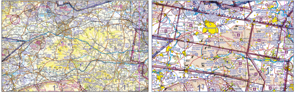
Figure 1: 1,250,000 vs 1:500,000 chart
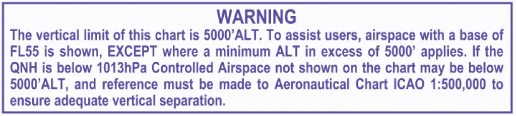
Figure 2: 1:250, 000 chart warning to remind users of the vertical limits
The infringement lasted 9 minutes 32 seconds. Figure 3A shows the area on a 1:500,000 chart. Figure 3B shows the same area on the chart available to the instructor in the cockpit.
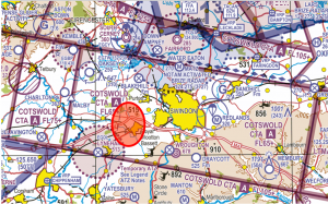
Figure 3A: Area shown on a 1:500,000 chart
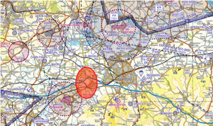
Figure 3B: Area on the chart available to the instructor
When it became clear that prevailing weather conditions required a change to the plan after departure the instructor should have either abandoned the flight or revised their plan. To mitigate against risks associated with over confidence/complacency their revised plan needed decisions based on aeronautical information available in flight, rather than perceived knowledge.
The instructor chose to operate without a Moving Map. The CAA and safety partners actively encourage all pilots to incorporate the use of Moving Maps in both pre-flight planning and in-flight. When properly configured and used effectively, a visual and aural airspace warning would have been given alerting the pilot of their proximity to controlled airspace.
The instructor failed to recognise the Threats associated with cloud base and strong winds aloft. This resulted in the pilot losing situational awareness of the aircraft’s position. Once above cloud and unable to maintain positional awareness, the pilot made an Error in not requesting an air traffic service (ATS) from the local Lower Airspace Radar Service unit; Brize Norton is just 12NM from the location of the infringement.
At 1003 hPa, the QNH was not uncharacteristically low but it meant that the aircraft was some 300 feet higher on the local QNH when adjusted for the Standard Altimeter Setting (the correct pressure datum of the Cotswold CTA). However, the aircraft was still flown some 600 feet higher than the base of controlled airspace. Had the Instructor had the correct chart available and having stated they were aware of the Class A airspace with a base of FL065, they should have incorporated a maximum altitude of 6,000 feet on the QNH of 1003 hPa into their plan to remain below controlled airspace. This, in line with Take 2 guidance, would have ensured they were operating below the CTA and have a buffer of 200 feet to allow the management of the Threats associated with turbulence or student handling error.
When the pilot eventually displayed a Brize Norton SSR code the unit was unable to establish 2-way communications. In the first instance a pilot should only select the conspicuity code (3737) when instructed to do so or in accordance with local procedures. Had the pilot intended to display the Frequency Monitoring Code (Listening squawk) the code selected should have been 3727 with the relevant frequency selected (124.275 MHz).
Instructors often lower the volume of the comms panel/radio during instructional flights as constant R/T can distract the student and impede in-cockpit talk between instructor and student. It is not uncommon in occurrence involving instructional flights for ATC not to be able to establish communication with the pilot for this reason.
Focus on
- Pre-flight planning and preparation
- Use of Moving Maps
- Threat & Error Management
- Altimetry – Key tips
- Lower Airspace Radar Service (LARS)
- Frequency Monitoring Codes (Listening Squawks)
Infringement of Class D and Class A airspace – Gatwick Control Area and London Terminal Control Area
| Aircraft Category | Fixed-wing Microlight |
| Type of Flight | Recreational Flight |
| Airspace/Class | Gatwick CTA / Class D and London Terminal Control Area (LTMA) / Class A |
The Air Traffic Controller
The Air Traffic Controller reported receiving a Controlled Airspace Infringement Tool (CAIT) alert of an aircraft squawking 7000 indicating 1,800 feet briefly enter the Gatwick Control Area (CTA). Some 13 minutes later, the aircraft was seen to enter the LTMA in the vicinity of the Mayfield VOR/DME (MAY) at 2,900 feet. Whilst the controller was planning what action was required to ensure separation was maintained with an aircraft inbound to Gatwick Airport, the unknown aircraft descended below controlled airspace.
These infringements did not result in a Loss of Separation due to the significant reduction of commercial traffic at Gatwick associated with COVID-19. But under normal traffic conditions, due to the location of the infringements, this event may have caused a safety event and considerable workload for commercial pilots and controllers.
The Pilot
The pilot reported that the flight was planned to fly from Headcorn to Deanland and return to Headcorn later. The cloud base at the time was approximately 1,600 feet and the visibility was good. Despite the good visibility, the lower than expected cloud base did cause some distraction.
The aircraft was equipped with, and the pilot was operating, a MODE S transponder and squawking 7000 with MODE C. Whilst aware of the benefits of moving map technology, the pilot had chosen not to use one as they did not want to become over reliant on it to avoid degradation of conventional navigation skills.
The pilot had planned the flight, and was using a 1:250, 000 VFR chart, although no route line was drawn on the chart. Flying a heading of 240 degrees the pilot misidentified Bewl Water as Darwell Reservoir resulting in them being north of their intended track. This led to being too far to the west when trying to visually locate Deanland, the destination aerodrome. Having failed to locate Deanland, the pilot decided to return to Headcorn and turned left onto a reciprocal track when approximately 3NM southeast of Haywards Heath. When the cloud base improved, a climb was initiated but as they were further west than they thought, the pilot infringed the LTMA as they were still under the area where the base is 2,500 feet.
Meteorology
The TAF at the time of the Infringement forecast an improving cloud base after 0700 hours UTC:
EGKK 060458Z 0606/0712 20007KT 9999 BKN010
TEMPO 0606/0607 BKN007
PROB30 TEMPO 0606/0607 6000 -RADZ BKN004
BECMG 0607/0610 SCT030
PROB30 0702/0707 8000=
The METARS as issued:
0750 EGKK 060750Z 19007KT 160V230 9999 BKN013 20/17 Q1007=
0820 EGKK 060820Z 21006KT 160V240 9999 BKN012 20/17 Q1018=
0850 EGKK 060850Z 22007KT 190V250 9999 BKN015 21/17 Q1018=
Causal Factors
The pilot had planned to carry out a direct flight to Deanland. Based on the aircraft’s speed and the relatively short distance of the flight the decision to fly using 1:250,000 chart was sound and greater definition of route features were available. However, in selecting an initial incorrect heading, the outbound track was offset to the north of the water feature of Bewl Water (A in Figure 1). The pilot knew that they wanted to be north of Darwell Reservoir (B in Figure 1) and once airborne from Headcorn and visual with a large water feature, the pilot became subject to confirmation bias.
In the pilots mind they expected to see a water feature to the south. Because the pilot was familiar with the area and had flown the route many times, they knew that they needed to be just to the north of Darwell Reservoir. The sight of a body of water to the left of the route meant that the pilot’s expectations were confirmed, and the sensitivity of the error detection mechanism was reduced at a time when mental capacity was also taken up with the distraction of lower-than-expected cloud. By keeping Bewl Water to their left the pilot was destined to infringe the Gatwick CTA.
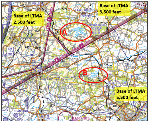
Figure 1 Bewl Water and Darwell Reservoir
The pilot’s planning was complacent due to the number of times the route had been flown and their knowledge of the area:
- No attempt was made to obtain the upper winds by using the MetForm 214 or other APPS.
- A line was not drawn on a chart between Headcorn and Deanland.
- A Navigational Plan/ Log (PLOG) was not constructed for the flight.
As a result of the 2,000 feet wind on the day (approximately 180 degrees /10 knots), the heading flown gave a ground track (red line in figure 2) of approximately 250 degrees. The heading required to fly a direct track from Lashenden to Deanland was approximately 224 degrees (purple line in figure 2). With a lowering cloud base en route, the pilot became distracted from the navigation task and the effects of the initial heading error were not challenged.
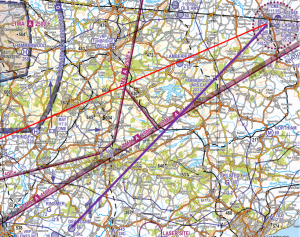
Figure 2 Ground and direct tracks
The pilot’s normal method of navigation was to use dead reckoning techniques. Had the pilot used a moving map, even just as a back-up, they would have quickly identified that the aircraft was significantly off track and that Bewl Water was not Darwell Reservoir. In addition, as the pilot approached the Gatwick CTA, with correct configuration, a visual and aural warning could have been provided. These warnings are triggered when the horizontal and vertical trajectory would take an aircraft into a volume of controlled airspace. An onscreen warning is often accompanied by an audible alert, the form of which depends on the type of airspace, and a thick border may be drawn on the map accompanied by large coloured arrows to highlight which piece of airspace is associated with the warning. The CAA and safety partners actively encourage all pilots to incorporate the use of moving maps in both pre-flight planning and during flight.
At no time did the pilot believe they were lost. They became uncertain of their location when they were unable to locate Deanland which the pilot commented is not an easy aerodrome to locate due to the surrounding landscape. However, being unable to locate the aerodrome should have been a trigger to seek assistance from an Air Traffic Service Unit. A number of options were available including calling D&D on 121.500MHz for either a position fix or a steer to Deanland; calling Gatwick on 126.825MHz or Farnborough LARS (East) on 123.225MHz.
A chart showing areas of responsibility for the UK LARS units can be found in the UK AIP at ENR6.11. In the case of Farnborough LARS, there are annotations on the VFR Charts (see figure 3). A last barrier could have been the use of the Frequency Monitoring Code (FMC) for Gatwick. Although the intended track of the flight would have been 2NM to the south of the published area for the Gatwick FMC (7012 and 126.825MHz), the first, brief, infringement, would have been acted upon by the Gatwick Director which may have acted as a trigger to the pilot that they were some 8.5NM north of track.
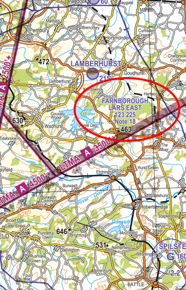
Figure 3 Farnborough LARS East
Focus on
- Use of Moving Maps
- Frequency Monitoring Codes (Listening Squawks)
- Threat & Error Management
- Confirmation Bias
- Lower Airspace Radar Service (LARS)
Other narratives in this series can be found on the Infringement occurrences page
Infringement of Class D – Manchester Control Area
| Aircraft Category | Fixed-wing Microlight |
| Type of Flight | Recreational Flight |
| Airspace / Class | Manchester CTA / Class D |
Air traffic control
The Manchester radar controller was alerted to an aircraft squawking 7365 a few miles to the northeast of Barton aerodrome. The aircraft was indicating an altitude of 2,400 feet (1). The base of the Manchester CTA is 2,000 feet.
Mode S allowed the aircraft to be identified so the controller was able to contact the Barton Flight Information Service Officer (FISO). After a second call to Barton the aircraft descended.
The aircraft was inside controlled airspace for 3 minutes and 36 seconds before leaving the CTA. No other traffic was affected by the infringement.
The Barton FISO explained that the unit is part of an ADS-B (Automatic Dependent Surveillance–Broadcast) trial. This allows a FISO to offer generic traffic information (TI) to pilots operating within the unit’s designated operational coverage (DOC). Manchester Barton’s DOC is notified as 10NM/3,000 feet. Generic traffic information is given using phrases such as “in your vicinity”. The FISO could see that the frequency had not been changed to Warton after the aircraft left the unit’s DOC heading north. So issued TI on traffic that was approaching position from the east (see figure 1).
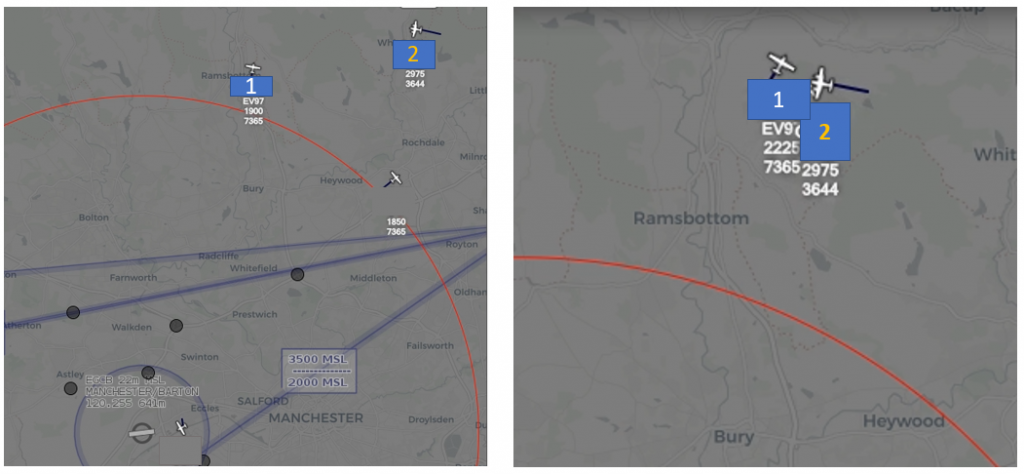
Figure 1: The position of the aircraft is shown as ‘1’ and the approaching traffic as ‘2’
On recovery to Barton, the pilot informed the FISO that they were over Bury (figure 2). The FISO issued TI against an aircraft that was departing the ATZ northbound in a reciprocal direction.
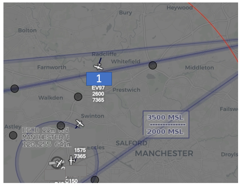
Figure 2: Position of the aircraft over Bury
At that point the aircraft was inside the DOC area, and the FISO commented to their assistant that, based on ADS-B altitude, the aircraft appeared high compared with the reported altitude.
The FISO was about to ask the pilot to confirm their altitude and pass updated information on the opposite traffic when the Manchester radar controller called to let them know the traffic was too high. The pilot was informed and carried out a descent out of the CTA to the correct altitude for an overhead join.
Pilot
The pilot was carrying out a VFR sightseeing flight from Barton to Rawtenstall via Bury and Ramsbottom (figure 3).
On the day of the flight, met conditions were good. Visibility was in excess of 10km with some cloud detected at around 4,000 feet and a light and variable surface wind.
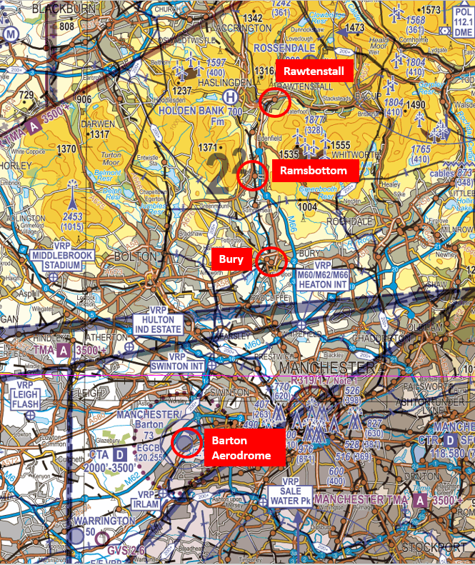
Figure 3: Flight from Barton to Rawtenstall via Bury and Ramsbottom
The pilot usually flew with a fellow pilot to supplement each other’s navigation, lookout and communications. On this occasion they were flying solo as their flying partner was unavailable. The pilot was flying the EV97 for the first time in some months. The pilot was using a 1:250,000 VFR chart and a basic version of a VFR moving map application on their mobile phone. This was secured in a mount on the right-hand side of the instrument panel due to the location of the 12V socket and position of the mount. The pilot explained that mounting a moving map is limited to the right-hand side as nothing can be fixed to the canopy. This meant that altitude information was very difficult to see from the left-hand seat. The aircraft was not equipped with either strobes or a beacon and, due to its bare aluminium colour, the pilot was aware that it was harder to see air-to-air than white microlights. The pilot remained on the Barton frequency throughout the flight and was in receipt of a Basic Service from Barton Information.
On the outbound leg, the FISO issued a warning of a much faster aircraft heading in a reciprocal direction. The microlight pilot became extremely anxious that the pilot of the conflicting aircraft would not become visual and all their focus turned to lookout, scanning all around in an unsuccessful attempt to catch sight of the aircraft. Although trimmed for level flight, the microlight had started a gradual climb from Bury to reach an altitude of 2,700 feet at Rawtenstall. Due to their focus on scanning, the pilot had not realised that the aircraft had climbed approximately 1,000 feet above their intended cruising altitude. On turning back towards Barton, and not realising they had climbed so much, a quick glance at the altimeter told the pilot that the aircraft was at *,800 feet. Having intended to fly at around 1,700 feet, the pilot mistakenly took this reading to be 1,800 feet. It was really 2,800 feet. The pilot started a gradually descent of 300 feet to what they thought was 1,500 feet, but was actually 2,500ft. This altitude was maintained the rest of the way back to the Barton overhead.
The pilot made two position reports en-route at this altitude of “Overhead Bury, one thousand five hundred feet” and “Half a mile north of Swinton Interchange at one thousand five hundred feet”. Overhead Barton, the FISO asked the pilot to check their altitude at which point they realised that the needle on the altimeter was pointing towards “2” not “1”. The pilot apologised whilst commencing a steep descent into the Barton circuit. The pilot added that a smaller aircraft or one with less performance in their proximity, “as often happens around Barton”, would not have caused them so much concern. But the warning of a larger aircraft travelling at a much higher speed triggered a serious worry about the risk of a mid-air collision had affected their concentration.
Figure 4 shows an approximate representation of the flight profile.
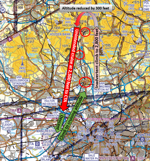
Figure 4: Approximate representation of the flight profile.
After the event the pilot analysed the occurrence, and noted a number of factors that led to them not noticing the higher altitude:
- Better conspicuity would lessen the stress of not being seen by other aircraft thereby reducing their focus on external scan and allowing some division of attention between lookout and instrumentation.
- A check of the basic version of the VFR moving map technology led them to note that their version did not offer warnings of possible vertical infringements.
- The mobile phone was positioned so far away from the pilot that they could not get an independent altitude check from that equipment.
- In previously flown aircraft, they recall seeing an additional display within the altimeter showing the altitude in numbers.
Causal factors
The pilot had planned to carry out a sightseeing flight to the north of Barton. The decision to use a 1:250,000 chart, allowing greater definition of the route features, was good based on the aircraft’s speed and the relatively short distance of the flight (approximately 15NM from Barton aerodrome). The use of a chart for navigation was supported by a VFR moving map.
However, in becoming distracted in trying to visually acquire conflicting traffic, an inadvertent climb resulted in the aircraft eventually reaching 1,200 feet higher than the intended cruising altitude.
The pilot was subject to confirmation bias. They knew they wanted to fly at or around 1,500 feet and the small needle on the altimeter pointed to 800 feet. In the pilots mind they expected to be at or around 800 feet. Having not flown the EV97 solo for some time, they were not surprised to have reached a slightly higher altitude by a few hundred feet.
Nothing in their plan or the small needle on the altimeter was to indicate that they were over 1,000 feet higher than intended. The confirmation bias could have been broken by one, or both of the following:
- The pilot normally flew with another pilot who has a tablet device with a ‘full’ version of a VFR moving map application. Had the pilot has such a device/version, even as a back-up to their using the 1:250,000 VFR chart, they would have had the benefit of a larger display which would have provided them with alerts as they climbed up to 2,800 feet with the Manchester TMA being above them at 3,500 feet. It would also have provided an alert on the inbound leg as they approached the Manchester CTA some 300 feet above the base altitude and then again as the CTA base stepped down to 2,000 feet.
These warnings are shown when the trajectory, both horizontal and vertical, would take an aircraft into a volume of airspace. An onscreen warning is often accompanied by an audible alert, the form of which depends on the type of airspace, and a thick border may be drawn on the map accompanied by large coloured arrows to highlight which piece of airspace is associated with the warning.
The CAA and safety partners actively encourage all pilots to incorporate the use of moving maps in both pre-flight planning and during flight. On this occasion, the pilot had not applied active Threat and Error Management in relation to their equipment in respect of the size and position of the display and the functionality of the ‘basic’ version of the application. In addition, the lack of options for the position of the mount may have played a part in accessing data from the moving map. - Had the pilot elected to obtain an air traffic service from the local LARS unit at Warton on 129.530MHz the chain of events may have been broken. On initial contact the pilot may have noticed the error when passing their details to the controller or, when they told Warton Radar that they were at 1,800 feet, Warton Radar would have noted an error in the Mode C when carrying out the verification and validation process during identification for a radar service. The Barton DOC is notified as 10NM/3,000 feet. When leaving the DOC area northbound, the pilot would have been better served getting a service from Warton.
The pilot became task saturated. While trying to visually acquire the aircraft for which they received information they failed to note an inadvertent altitude change. The pilot cannot be criticised for being risk aware and concerned of the developing situation. However, the use of an electronic conspicuity device on a larger display and/or the provision of an air traffic service are effective mitigations of mid-air collision. With mitigations in place capacity can be increased and stress levels reduced.
Having operated the EV97 for some time some skill fade may also have been a contributory factor.
Post-flight analysis
The pilot is commended for carrying out such detailed post-flight analysis of the occurrence (including the submission of a detailed and honest report), their approach to the factors surrounding the occurrence and for following Just Culture principles.
In addition they immediately engaged the services of a flight instructor to obtain remedial refresher training to ensure that issues could be addressed and rectified.
Focus on
- Use of Moving Maps
- Threat and Error Management – Read Threat & Error Management
- Confirmation Bias – Read SKYbrary Confirmation Bias
- Provision of an Air Traffic Service – Read Lower Airspace Radar Service (LARS)
- Use of Frequency Monitoring Codes – Read Frequency Monitoring Codes (Listening Squawks)
(1) Please note that Mode A code and Mode C pressure-altitude have not been verified.
Other narratives in this series can be found on the Infringement occurrences page.
Infringement of Class D – Birmingham Control Area
| Aircraft Category | Helicopter |
| Type of Flight | Recreational Flight |
| Airspace / Class | Birmingham CTA / Class D |
Air traffic control
The Air Traffic Controller reported seeing an aircraft squawking 7000 enter the Class D CTA-2 near Warwick at 2,000 feet (Figure 1). It appeared to be following the M40 northbound. The aircraft descended to 1,800 feet then made a right turn and tracked eastbound climbing to 2,300 feet. The aircraft eventually turned southeast and left the CTA south of Coventry aerodrome. Multiple attempts to contact the aircraft were made on the frequency with no response.
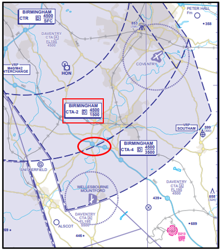
Figure 1: The aircraft entered the Class D CTA-2 near Warwick at 2,000 feet.
Pilot
The pilot reported that they had planned a route to fly for their first solo flight as a PPL holder: Leicester Aerodrome – Deenethorpe Aerodrome – Podington racetrack – Olney VRP – Silverstone Circuit – Chipping Warden – Draycote Water VRP – Peter Hall Farm – Nuneaton VRP – Bruntingthorpe Aerodrome – Leicester Aerodrome.
The route had been planned on a VFR moving map on a tablet and transposed on a 1:250,000 VFR chart (figure 2). This was the first time they had used their personal iPad and the GPS stopped working 10 minutes after take-off.
As they had a well-prepared VFR chart, they continued with the flight having never had to rely on GPS previously when flying solo even though they had not flown the southern part of this route south of Northampton before.
After turning at Silverstone they had not noted the time and commented that they must have overshot Chipping Warden but, on seeing motorway, tracked it northwest bound until they could see Draycote Water VRP. By this time, they were beyond the area that was visible on the chart due to the way it was folded. As a result, they did not see the Class D CTA-2 with a base of 1,500 feet. Had they done so, they would have turned 180 degrees and tracked back down the motorway to avoid it.
The pilot added that they did not elect to obtain an air traffic service as they had to use the aircraft registration as their callsign instead of the instructors callsign used during training. In addition, as they routed northbound, they did not utilise the Birmingham Frequency Monitoring Code (FMC) of 0010 and listen out on 123.980MHz as they had not been taught about FMC during their training. At the time of the flight, the pilot reported there to be scattered cloud (3-4 oktas) at about 2,300 feet with good visibility below.
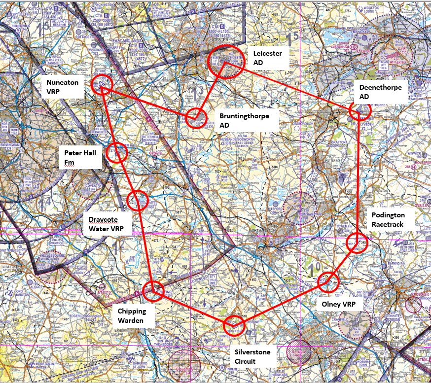
Figure 2: The planned route shown on 1:250:000 VFR chart.
Causal factors
The pilot had carried out good planning to carry out their first solo flight after the award of their licence. They had selected prominent geographical features as turning points and in accordance with good practice had planned to use a tablet-based VFR moving map with the paper chart as a back-up.
Shortly after departure, their GPS position failed as they were unaware that the tablet needed to be tethered to their phone as the tablet was not a cellular version.
The pilot lost situational awareness as to their position sometime after their waypoint at Silverstone Race Circuit (figure 3). Having been unable to locate the next waypoint at Chipping Warden, decided to follow the M40 motorway northbound. Due to the lack of aeronautical information available to the pilot, they entered the Birmingham CTA-2 to the southwest of Warwick at 2,000 feet where the base of controlled airspace is 1,500 feet.
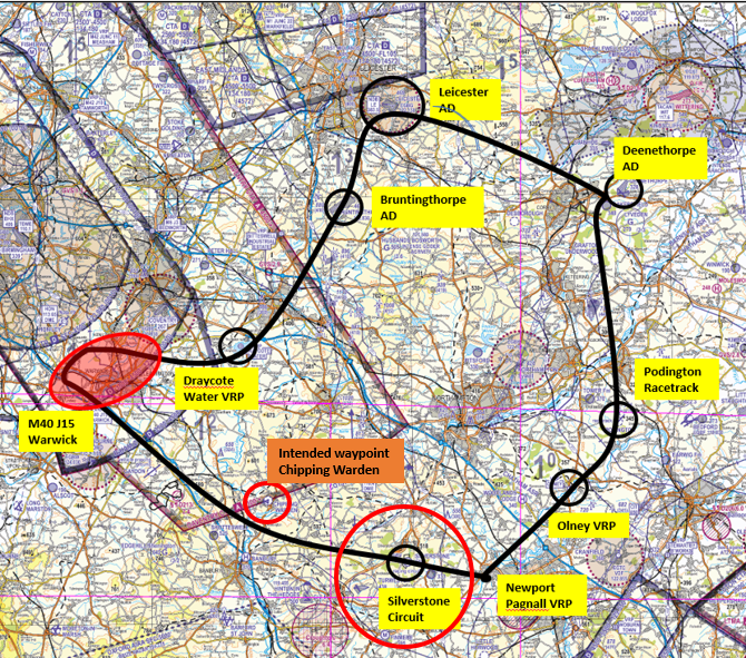
Figure 3: Situational awareness as to their position was lost sometime after the waypoint at Silverstone Race Circuit.
In their pre-flight planning, the pilot applied good Threat and Error Management in marking the route on a paper chart. However, the manner in which the chart had been folded did not leave sufficient airspace and ground features visible to aid navigation. It is essential, as part of pre-flight preparation that you are not only familiar with the equipment functionality and limitations that you intend to rely on in-flight but that contingency measures are suitably prepared.
As the pilot routed northbound from Chipping Warden, as part of the initial plan, good practice would have been to employ the use of a Frequency Monitoring Code (FMC) by selecting the Birmingham frequency of 123.980MHz and then selecting a squawk of 0010 Mode C as their intended route would have taken them close to the Birmingham CTA and well within the notified FMC area of recommended use (see UK AIP EGBG AD2.22 Flight procedures paragraph 7 and the chart at UK AIP ENR 6.80). The FMC is also annotated on the chart (figure 4). However, it was not incorporated into their plan as, at the time of the occurrence, the pilot was unaware of FMC and their use. Had they been aware, the infringement would have been resolved in a timely manner and navigation assistance offered at an early stage of the occurrence.
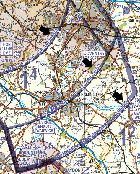
Figure 4: FMC annotated on the chart.
The pilot first became uncertain of their position when they missed their turning point at Chipping Warden having not noted their time at Silverstone. However, being unable to locate the aerodrome should have been a trigger to seek assistance from an Air Traffic Service Unit. A number of options were available including calling D&D on 121.500MHz for either a position fix or a steer to Draycote Water or calling Birmingham on 123.980 MHz for assistance or the LARS unit at Brize Norton on 124.275MHz (offering a service radius of 40NM daily between 0800 hours UTC and 1600 hours UTC).
However, due to the lack of experience of the pilot and then having only ever used an instructor callsign throughout their training rather than their aircraft registration. A lack of confidence in the use of the radio impaired their decision making. It is important for pilots to understand that air traffic control is there to help them and that controllers are used to offering navigational assistance when required.
A chart showing areas of responsibility for the UK LARS units can be found in the UK AIP at ENR6.11. Further details on units participating in the Lower Airspace Radar Services can be found in the UK AIP at ENR 1.6.4 (figure 5).
Figure 5: Lower Airspace Radar Services can be found in the UK AIP at ENR 1.6.4.
Post-flight analysis
This unfortunate occurrence occurred so soon after the pilot had completed their training due to gaps in knowledge, a lack of confidence in operating their radio in flight and lapses in Threat and Error Management.
The pilot is commended for carrying out such detailed post-flight analysis of the occurrence (including the submission of a detailed and honest report), their approach to the factors surrounding the occurrence and for following Just Culture principles.
Focus on
- Threat and Error Management – Read Threat & Error Management
- Use of Moving Maps
- Provision of an Air Traffic Service – Read Lower Airspace Radar Service (LARS)
- Use of Frequency Monitoring Codes – Read Frequency Monitoring Codes (Listening Squawks)
Other narratives in this series can be found on the Infringement occurrences page.
Infringement of Class D – Birmingham Control Area
| Aircraft Category | Fixed-wing SEP |
| Type of Flight | Qualifying Cross Country PPL Training Flight |
| Airspace / Class | Birmingham CTA / Class D |
Met information
- TAF EGBB 070459Z 0706/0806 26009KT 9999 SCT030
- TAF EGBB 071056Z 0712/0812 27010KT 9999 SCT030
- METAR EGBB 071150Z 28009KT 240V320 9999 FEW035 BKN044 13/06 Q1013=
- METAR EGBB 071220Z 27011KT 240V310 9999 BKN042 14/06 Q1013=
- METAR EGBB 071250Z 28012KT 9999 BKN044 14/05 Q1013=
Air traffic control
The Air Traffic Controller reported being alerted, by the Airspace Infringement Warning tool, to an aircraft entering the Class D CTA-2 to the east of Coventry aerodrome at 2,500 feet, squawking 0010. The aircraft is seen to track east to west at the boundary with CTA-4 (figure 1). Due to another aircraft in the vicinity it takes a moment to interrogate the radar to establish, using MODE S, the identity of the infringing aircraft. The aircraft, having left controlled airspace tracked south and remained outside of controlled airspace until landing at Wellesbourne Mountford aerodrome.
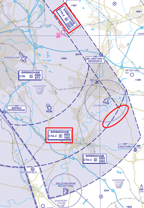
Figure 1: Aircraft is seen to track east to west at the boundary with CTA-4.
Pilot
The pilot reported that they had planned the route to fly for their solo qualifying cross-country flight as follows:
- Wolverhampton/Halfpenny Green Aerodrome (EGBO) to Blithfield Reservoir – 22 NM
- Blithfield Reservoir – Pitsford Water – 48NM
- Pitsford Water – Wellesbourne Mountford Aerodrome (EGBW) – 29NM
The route had been planned on a VFR 1:500,000 chart (figure 2) and a neat and comprehensive Pilot Log (PLOG) (figure 3) was produced using the methods taught on the navigation module of the PPL course. Prior to departure, the student pilot and their instructor reviewed the plan and weather conditions. The reported conditions on that day seemed to be reasonable and the flight was authorised. They discussed using the Birmingham Frequency Monitoring Code of 0010 to allow for easier identification when flying close to Birmingham’s controlled airspace.
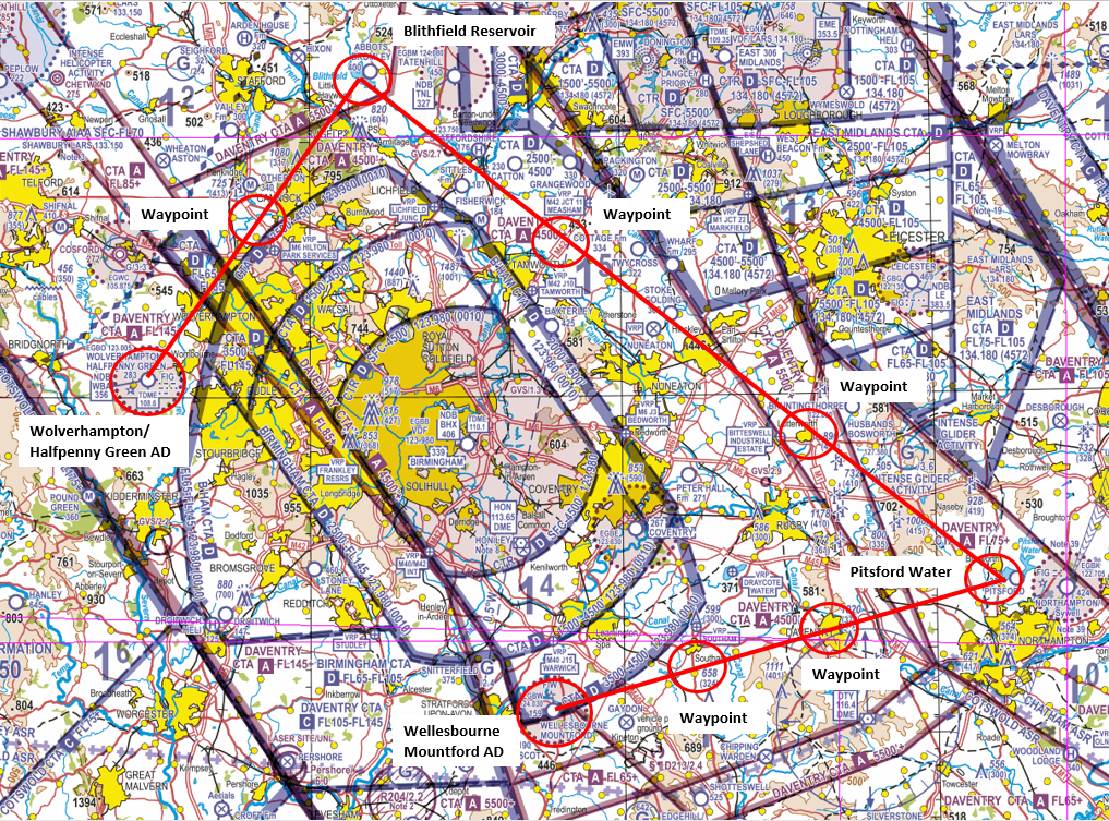
Figure 2: Route planned on a VFR 1:500,000 chart.
Although the PLOG has space for Regional QNH the pilot was aware of the risks of operating close to controlled airspace if a Regional Pressure Setting (RPS) is used and elected to use the Birmingham QNH.
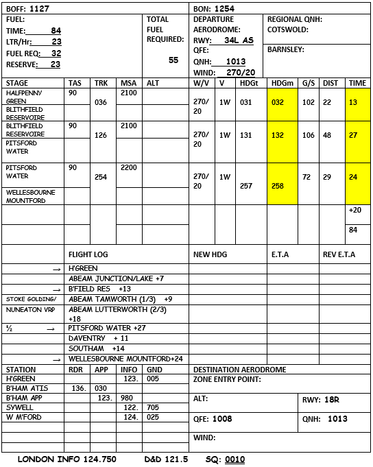
Figure 3: Comprehensive Pilot Log (PLOG)
Although the pilot had flown many navigation exercises and had done two solo navigation flights prior to the subject flight, they had only flown this particular route with their instructor on one occasion, three weeks earlier.
After departure, the pilot noted that the visibility was good, but the wind was much stronger than expected. This resulted in some challenges to maintain headings and the vertical instability of the air meant it was difficult maintaining altitude. Therefore, a large portion of their time was spent on maintaining the heading and altitude leading to a significant increase in workload in flying the aircraft. It also resulted in their calculated timings not being as accurate. The pilot had had changed frequency to monitor Birmingham Approach on 123.980 MHz and displayed the FMC of 0010. They had not spoken to them as they had been busy trying to maintain their heading and altitude as well as navigate.
During the leg between Blithfield Reservoir and Pitsford Water, the pilot became uncertain of their location and had circled above Nuneaton VRP several times to establish a positive location fix. Unfortunately, they had not reset the timer in the aircraft before setting off from this point. Continuing on with the route, they flew over a body of water (Stanford Reservoir) which they mistook for Pitsford Water. As the student neared what they thought was Pitsford Water, the pilot selected an SSR code of 7000 and called Sywell Information on 122.705 MHz to inform them of what they thought was their location. Shortly after leaving the turning point that had been mistaken for Pitsford Water, the pilot changed frequency back to Birmingham Approach and selected the FMC of 0010. Given that their timings were already out, compounded by their lack of familiarity with that area of the country, they did not realise that the lake/reservoir was roughly 10 nautical miles before Pitsford Water. Therefore, when the pilot turned onto the heading for Wellesbourne Mountford it was made too early and had put them on track towards controlled airspace (figure 4). Unfortunately, at that time, there were several other aircraft that were contacting the controller; therefore the pilot could not call them.
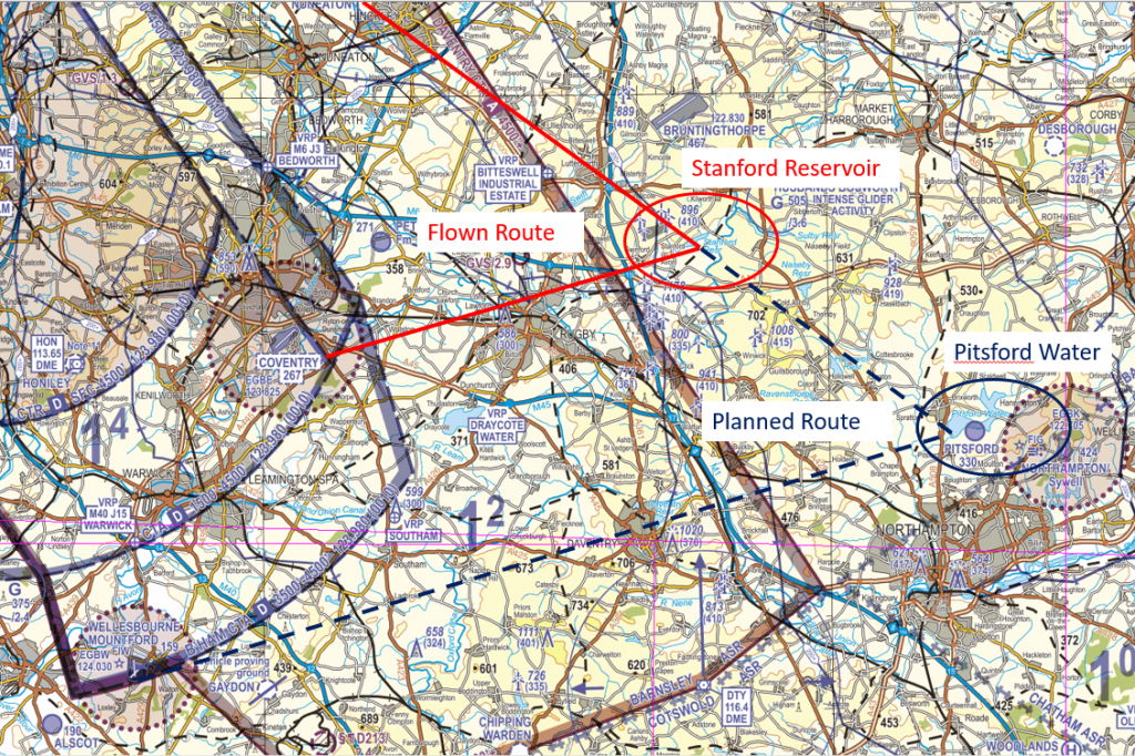
Figure 4: Planned and flown routes.
Realising, that they were flying in an area that did not correlate with the route plan and being unable to contact Birmingham, the pilot changed their heading to south and called Distress and Diversion (D&D) on 121.500MHz. They promptly provided the pilot with a position fix and, once aware of their location, the pilot was able to navigate to Wellesbourne Mountford. On landing at Wellesbourne Mountford, once parked, the pilot immediately telephoned their instructor at Halfpenny Green and explained the problems that they had experienced en-route.
Findings and causal factors
The pilot had carried out good planning which was endorsed by their Flight instructor; the plan incorporated prominent turning points and waypoints en-route. The weather was fit for solo VFR flight by a student although some unstable air resulted in increased cockpit workload associated with aircraft handling. The route was to be flown 1,000 feet above MSA which provided ample vertical separation from controlled airspace; in accordance with the Take 2 guidance (remaining 2NM laterally clear and/or 200 feet vertically clear of controlled airspace) the planned route demonstrated text-book Threat and Error Management in this aspect.
The pilot has also decided to incorporate the use of a Frequency Monitoring Code (FMC) into their plan due to the proximity of the route to the Birmingham controlled airspace complex. On leaving the Birmingham frequency south of Nuneaton, they selected 7000 after selecting the Sywell Information frequency prior to transmitting. Once west of their turning point they again selected the Birmingham frequency followed by the FMC in accordance with good practice. The pilot was, however, not fully aware that when using an FMC, no transmissions are required with ATC unless responding to a call.
The student pilot was not flying with a Moving Map as their use had neither been taught in their training nor had they been encouraged to use one. The CAA actively encourage all pilots to incorporate the use of Moving Maps in both pre-flight planning and in-flight. TrainingCom (Spring 2020) states that it is important that instructors teach their students the use of GPS/GNSS aircraft systems when fitted to their aeroplane. The use of Moving Map displays should also be taught to enhance the student’s situational awareness once they have the basic Dead Reckoning (DR) navigation techniques. If the student uses these systems during solo-flying, this is permissible but they need to remember that they need to have the skills to later pass the licensing skills test. Therefore, it is the skills test that will be the time when the students DR Navigation techniques will be tested. Not only would a VFR Moving Map have provided the pilot with this enhanced situational awareness as they approached what they incorrectly thought was their turning point at Pitsford Water, but with a properly configured display, a visual and aural airspace warning would have been given alerting the pilot of their proximity to controlled airspace.
In the pilot’s mind they expected to see a body of water after Lutterworth, the second waypoint on the second leg. The pilot was on the correct ground track but due to a failure to incorporate the time taken to orbit at Nuneaton to establish their position, they became subject to confirmation bias. The sight of a body of water ahead on the route meant that the pilot’s expectations were confirmed, and the sensitivity of the error detection mechanism was reduced at a time when mental capacity was also taken up having just been unsure of their position and given the challenging air conditions. Despite Stanford Reservoir being less than a third of the size of Pitsford Water, the pilot was probably so relieved to see a lake, as planned, that they failed to compute that they had not yet reached their turning point. This chain of events could not have been broken when their position was passed to Sywell Information due to the lack of surveillance information available to the FISO.
The pilot first became uncertain of their position when the expected ground features from Pitsford Water to Wellesbourne Mountford were not visible (figure 5). By now back on the Birmingham frequency and squawking 0010, the pilot was unable to seek assistance from the radar controller. In need of assistance, the pilot immediately called D&D on 121.500MHz. Very few pilots revert to their training and may have continued on track in the hope of finding a recognisable feature whilst compounding the risks associate with an airspace infringement. On this occasion, the calm and logical execution of the Management technique of an identified Threat/Error enabled the pilot to establish a prompt resolution to the situation.
Any pilot who believes they are lost or temporarily uncertain of position should immediately seek navigational assistance from the appropriate radar unit. Alternatively, they should select code 0030 (FIR Lost) and contact D&D (callsign “London Centre”) on 121.500 MHz for assistance.
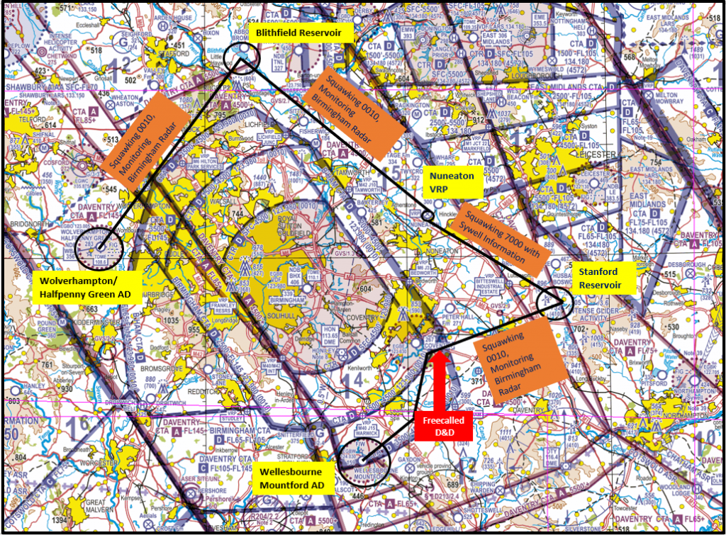
Figure 5
Post-flight analysis
Effective planning will always put you, as a pilot, in a position of strength for effective execution. But due to Human Factors, Threats and Errors will always exist and have the potential emerge.
In this occurrence, the pilot is to be commended for their handling of a stressful situation where an infringement was resolved in a timely manner. In addition, despite limited experience in the aviation community, they carried out a detailed post-flight analysis (including the submission of a detailed and honest report) and adopted a Just Culture throughout.
Focus on
- Threat and Error Management – Read Threat & Error Management
- Confirmation Bias – Read more at SkyBrary
- Use of Moving Maps
- Provision of an Air Traffic Service – Read Lower Airspace Radar Service (LARS)
- Use of Frequency Monitoring Codes – Read Frequency Monitoring Codes (Listening Squawks)
Other narratives in this series can be found on the Infringement occurrences page.
Infringement of the Class D East Midlands Control Area 2 and overflight of active winch-launch glider sites
| Aircraft Category | Helicopter |
| Type of Flight | Recreational |
| Airspace / Class | East Midlands / Class D |
Met information
- TAF EGNX 111102Z 1112/1212 31007KT 9999 SCT020
- METAR EGNX 111450Z 31007KT 270V340 9999 BKN035 12/05 Q1026=
Air traffic control
The Air Traffic Controller (Radar Director) reported vectoring a Commercial Air Transport aircraft on left base for and ILS approach to Runway 27 when an aircraft squawking 7000 was observed entering CTA-2 indicating between 2,000 and 2,300 feet on MODE C (Figure 1). The CAT aircraft, descending from 4,000 feet to 3,000 feet was instructed to stop its descent and turn onto a north-westerly heading. The aircraft levelled at 3,500 feet and passed approximately 4NM laterally and 1,000 feet vertical from the infringing aircraft.
The Air Traffic Controller (Radar/LARS) was operating in a bandboxed configuration (two frequencies combined, carrying out the functions of radar and LARS) and experiencing high workload due to multiple aircraft free calling East Midlands for air traffic services in Class G airspace and transits of controlled airspace. The infringing aircraft’s pilot established communications with LARS one minute and 7 seconds prior to entering controlled airspace but, due to the high workload, the pilot was instructed to standby and remain outside controlled airspace. The aircraft was then issued with a squawk, identified and instructed to vacate the CTA.
Figure 1: Aircraft squawking 7000 was observed entering CTA-2
Pilot
The pilot reported that they had planned the route to fly from a private site in North Yorkshire to Leicester via the Doncaster-Sheffield Airport overhead (Figure 2).
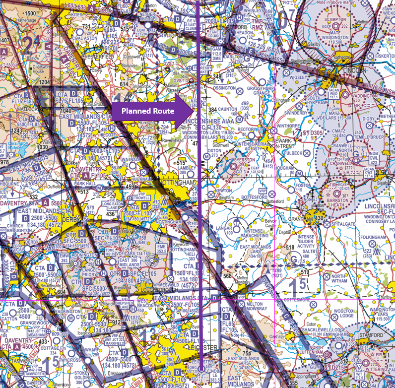
Figure 2: Planned route – North Yorkshire to Leicester via the Doncaster-Sheffield Airport overhead
The route had been planned on a VFR Moving Map and the pilot was also carrying a VFR 1:500,000 chart. After the Doncaster-Sheffield Airport overhead, the route was planned to be flown through, or underneath, the East Midland CTA. However, whilst under Radar Control from Doncaster Radar and having been given clearance to route through their overhead, the pilot was asked instead to route to the East of their intended route. The pilot was almost east abeam Retford/Gamston aerodrome by the time they were cleared to continue on their intended route. At that stage, the pilot determined that they could now track direct to Leicester aerodrome east of the East Midlands airspace.
However, the pilot still wanted to obtain a Basic Service, but the frequency was so busy that it took some 10 to 15 minutes to get their first transmission made. Whilst in the ‘queue’ to receive a squawk from East Midlands Radar, the pilot realised that the Langar parachute drop zone was active. Eager to avoid the drop zone and keep an adequate lookout for the unusually large amount of traffic operating in the area, unfortunately the pilot allowed their track correction to the west to continue for too long before turning South. This caused them to inadvertently enter CTA-2 whilst at 2,000 feet. On being contacted by the LARS controller, the pilot immediately corrected their course eastwards and reduced their altitude as quickly as was safely possible, in order to vacate the CTA. The track flown is shown in Figure 3.
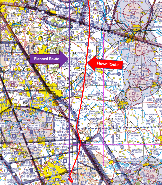
Figure 3: Track flown
Findings and Causal Factors
The pilot had formulated a sound primary plan to incorporate VFR transits of 2 volumes of controlled airspace: the Doncaster-Sheffield controlled airspace complex and the East Midlands CTA-2. However, lapses in planning result in no alternate plan (PLAN B) having been formulated in the event that a transit of either or both volumes of controlled airspace was not approved. When the pilot was issued a vector to route to the east of the Doncaster-Sheffield CTA they were now flying in an area that they had not planned to be in and had not considered from a Threat and Error Management perspective. As the pilot flew south, they overflew the following 2 winch launch glider sites at between 1950 feet and 2000 feet amsl: Darlton which is notified as operating sunrise to sunset (HJ) with cable launching up to 2,200 feet amsl and Syerston which is also notified as operating sunrise to sunset (HJ) with cable launching up to 3,300 feet amsl. In addition, the pilot flew through the Syerston Aerodrome Traffic Zone which, for the purposes of Rule 11 was notified in the UK AIP ENR2.2 (Other Regulated Airspace) as between 0730 hours and 15 minutes after Sunset from the surface to 2,231 feet amsl (Figure 4); on the date of the flight,, gliding was taking place at the aerodrome.

Figure 4: UK AIP ENR2.2
It is essential that whenever a flight is planned, an alternate route is considered by applying Threat and Error Management (TEM). Whilst air traffic control will make every effort to provide a crossing of controlled airspace on your requested route, it is good practice to anticipate that may not be the case. In formulating a ‘PLAN B’ it is essential to consider airspace structure and activities in the Class G airspace surrounding the controlled airspace that you plan to transit. As part of that planning, and application of TEM it is essential that you use the planning equipment to its optimum to consider all threats and risks. For example, on a paper VFR chart, winch launch glider sites are depicted with a blue circle and a G with figure in thousands of feet amsl to which the cable may extend e.g. G/3.3 signifying 3,300 feet. On the VFR Moving Map equipment that the pilot was using, the same area is depicted with a glider symbol but no maximum cable altitude in immediately visible. (Figure 5).
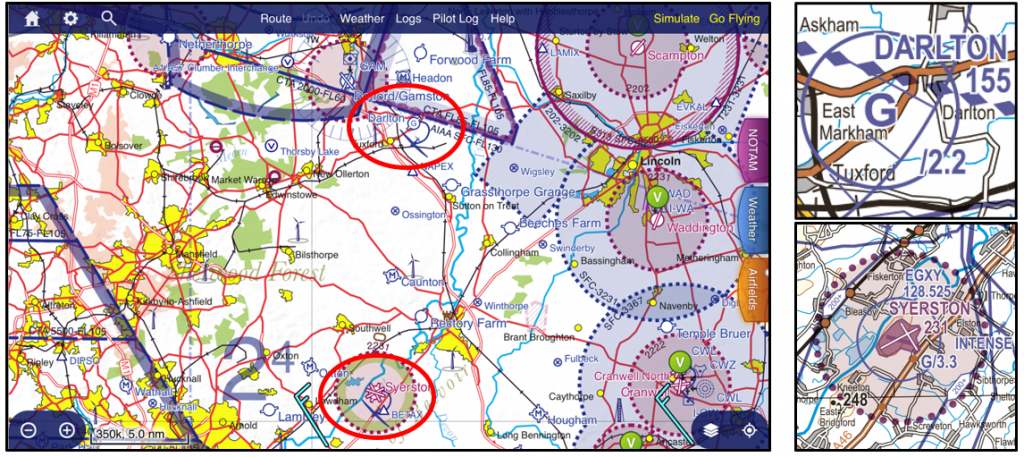
Figure 5: VFR Moving Map
To establish the winch launch altitude, a pilot is required to press on the location and review the tab which appears on the screen. The information is shown in the list containing waypoints, airspace and radio services and in the vertical extent to the side showing the elevation of the site, the maximum cable altitude and any other airspace such as an ATZ (Figure 6). This information is also contained in the UK AIP at ENR 5.5 (Aerial Sporting and Recreational Activities).
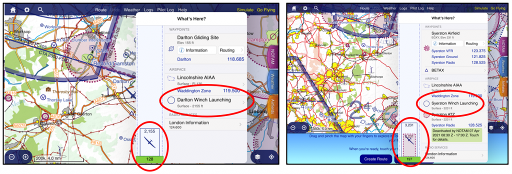
Figure 6: Winch launch altitude is shown in the waypoint list
It is important to note that any depiction of altitude relating to glider sites refers only to the maximum altitude of the cable. Glider activity can be expected to take place in the same area as either aero-tow or free-flight/soaring activity above the annotated altitude.
The pilot’s decision to route to the west of Langer and towards the East Midlands CTA also indicated lapses in effective situational awareness associated with ineffective TEM and pre-flight planning . The pilot commented that the East Midlands frequency was busy with multiple aircraft requesting a service. The pilot had already seen parachutes in the air from the jump aircraft at Langer. The wind at the time was from the west/northwest so the parachutists would have exited the aircraft to the west of the Langer drop zone. The pilot became fixated on maintaining an effective lookout as they were aware, based on how busy the East Midlands LARS controller was, that there were multiple aircraft in the vicinity of their track between Langer and East Midlands airport. This fixation resulted in Cognitive Lockup (the tendency of pilots to deal with disturbances sequentially) where they focused on the task of lookout and became reluctant to look at their Moving Map which would have not only given an alert as to their proximity to controlled airspace but would also have indicated that the pilot could have descended to at or below 1,500 feet and routed safely and effectively below CTA-2. The decision to switch or not to switch tasks may be influenced by a misperception of the expected benefits. This decision-making bias may mean that the benefits of switching have to be significant before the decision to switch is made. Furthermore, if an individual feels that the ongoing task is almost complete, they are more likely to stick to the ongoing task even if the new task is more urgent.
In addition, by making the decision to avoid Langer to the west (as the destination of Leicester lies to the southwest) the pilot was flying into a higher workload environment. A turn to the east would have added no addition distance to the flight and would have taken the pilot into less complex airspace and away from a traffic ‘funnel area’. In addition, it would have reduced cockpit workload, due to less radio telephony work. In their wider planning and decision making, had they considered applying the Take 2 guidance (Figure 7) of maintaining 2NM laterally from and/or 200 feet below controlled airspace, they may have altered their plan as they approached Langer to route into the more benign airspace to the east.
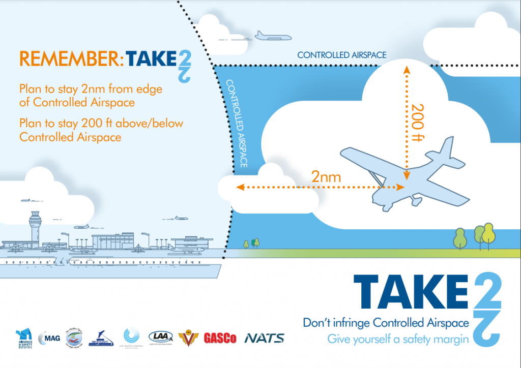
Figure 7: Take2
Post-flight analysis comment
Having an effective PLAN B will always put you, as a pilot, in a good position when external factors, such as weather, ATC restrictions or other traffic, influence your flight. It is relatively simple to make a sound plan and a backup plan or series of plans for each volume of airspace you fly in, or close to, and to incorporate effective Threats and Error Management in the various plans. It is, however, much harder to identify the onset and then override many of the Human Factors, such as Cognitive Lockup or Confirmation Bias that result in airspace infringements. That said, by being aware of their existence, it is possible to manage them; for example, a greater understanding of the risks in a particular sector of a route may also reduce the likelihood of cognitive lockup. In a multi-pilot operation, separation of tasks and roles between pilots, for example, by the captain passing control of the aircraft to the first officer while the captain deals with the malfunction, reduces the risk of both pilots fixating on the malfunction. Had their VFR Moving Map also been coupled to an Electronic Conspicuity (EC) device, this may have provided some situational awareness of participating EC traffic along with a timely warning of the proximity of controlled airspace.
Focus on
- Pre-flight Planning and the importance of a PLAN B
- Threat and Error Management – Read Threat & Error Management
- Use of Moving Maps
- Take 2 – Read TAKE2
- Cognitive Lockup – Read more at SkyBrary
- Provision of an Air Traffic Service – Read Lower Airspace Radar Service (LARS)
- Winch launch glider activity – British Gliding Association Winch cable warning poster
Figure 8: Winch Cables Can Kill!
Infringement of the Class A London Terminal Control Area
| Aircraft Category | Fixed-wing SEP |
| Type of Flight | Recreational |
| Airspace / Class | LTMA / Class A |
Met information
- METAR EGLL 191450Z AUTO 21014KT 9999 SCT033 SCT039 BKN046 19/11 Q1015 NOSIG=
Air traffic control
The Air Traffic Controller (Farnborough LARS West) reported providing air traffic services to five aircraft with a low to medium workload. The controller noticed an Airspace Infringement Warning (AIW) alert activate 3NM east of Wycombe Air Park/Booker aerodrome (Figure 1).
The AIW was associated with an aircraft squawking the Farnborough Frequency Monitoring Code (FMC) of 4572 indicating 3,300 feet where the base of the London Terminal Control Area (LTMA) is 2,500 feet (Figure 2).
The controller called the pilot who immediately replied. The pilot was then advised that the base of controlled airspace in their location was 2,500 feet. The pilot replied staying that they were descending. At the same time the Heathrow Special VFR controller called the Farnborough West controller to alert them of the event and was told that the subject aircraft was descending. On leaving controlled airspace, the controller obtained a level check from the pilot and verified that the aircraft’s MODE C was accurate.
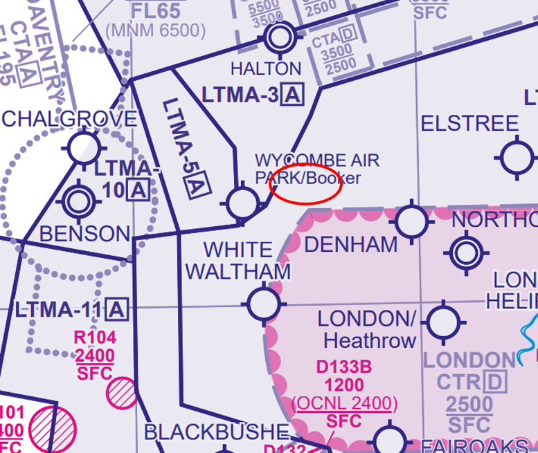
Figure 1 An AIW alert activated east of Wycombe Air Park/Booker aerodrome
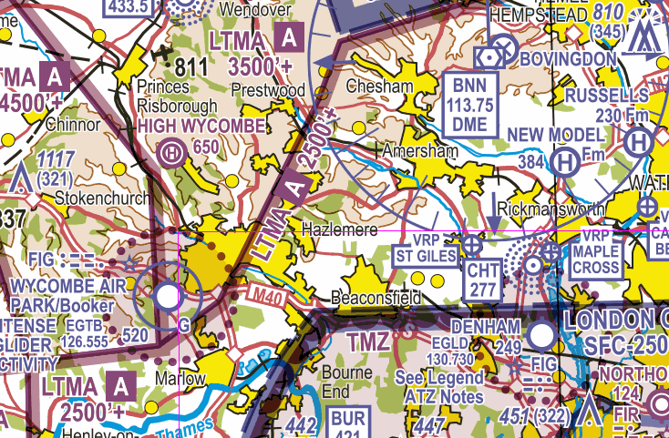
Figure 2 The base of the London Terminal Control Area (LTMA) is 2,500 feet
Pilot
The pilot reported that they had planned a VFR cross country flight from Dunkeswell aerodrome in Devon to Earl’s Colne in Essex. It was the pilot’s first lengthy cross-country flight since the UK had entered the first COVID-19 lockdown in March 2020. The weather was reported as CAVOK and the route planned to be flown was:
- Dunkeswell – Frome – Welford Discussed aerodrome – overhead Wycombe Air Park/Booker aerodrome – overhead Elstree aerodrome – LAM/ overhead Stapleford aerodrome – west of Chelmsford VRP – Earl’s Colne aerodrome (Figure 3).
The route had been planned on a VFR moving map to route to the north of the London CTR/TMZ and was one that the pilot had flown many times.
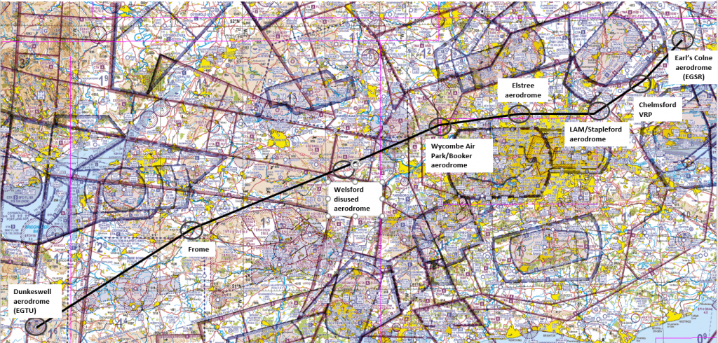
Figure 3 The planned VFR route
As the weather conditions were good the pilot wanted to fly as high as possible to maximise the views from the cockpit. They flew at 2,500 feet until Welsford (7NM southwest of the Compton VOR (CPT)) when they commenced a gradual climb to 3,300 feet, reaching that altitude overhead Wycombe Air Park/Booker aerodrome. The pilot commented that when using their VFR moving map, there were so many different alerts, most of which they felt were unnecessary, which led to them to habitually cancelling the warnings.
The pilot also stated that they used a personally prepared Flight Preparation checklist comprising five sections:
- Departure airfield;
- Arrival airfield;
- En-route;
- Flight plan (VFR only); and
- Survival/equipment.
In that list, “Altitudes” was included in the En-Route section only. After the occurrence, the pilot has added “Planned Altitudes” item to the “Flight Plan” (VFR Only) section. A copy of the checklist used at the time of the occurrence is at Table 1.
In addition, as soon as they were made aware of the occurrence, they submitted a detailed report and carried out effective post-flight analysis which resulted in revisions being made to their own check list to mitigate the risk of a recurrence.
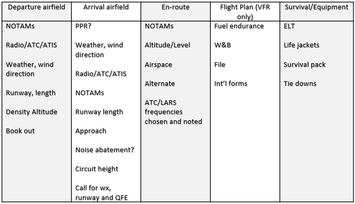
Table 1 Flight preparation checklist
Findings and Causal Factors
The pilot had formulated a sound primary plan relating to the route. However, insufficient consideration was given to the vertical portion of the route. The pilot’s own admission was that the planning of the flight was rushed and therefore incomplete. An essential aspect of planning is incorporating effective Threat and Error Management.
When planning it is good practice to break down the route into sectors/segments between waypoints. One of the threats which will affect many flights is airspace, whether that be controlled airspace, ATZ, TMZ /RMZ, restricted or prohibited airspace, danger areas, glider sites, parachute sites or minor aerodromes.
A threat that frequently emerges when using VFR moving maps and ‘rubber-banding’ the route between waypoints is that detailed analysis of what lies between the waypoints can be easily missed. By reviewing each sector/segment in detail, you can assess the lateral route and then plan for the maximum altitude to be flown (the lower limit of vertical controlled airspace less 200 feet if possible as part of Take 2) along with minimum safe altitudes.
If using a paper chart, it is good practice to write the maximum planned altitude alongside the MSA calculation or annotate it on your PLOG. If the route is too complex, or unachievable vertically, you may need to consider changing the track. Once those sectors/segments are finalised, it is then a good idea to insert additional waypoints along the route to indicate points at which a descent or climb can commence, in order to pass under a CTA or perhaps under lowering ‘steps’ in a TMA, or where it is possible to climb higher as the CTA/TMA ‘steps up’; remember to incorporate the Take 2 guidance into these points.
In addition, as the pilot had flown the route “many times”, there may have been an element of inadvertent complacency leading to a loss of situational awareness. The human factor of complacency has been equated with over confidence, a state of confidence plus contentment, low index of suspicion and unjustified assumption of satisfactory system state. In addition, when using a VFR moving map as the sole source of navigation, the pilot in essence becomes a system monitor. In 1998 Dr Tony Kern (author of books on human performance, including the ‘Plane of Excellence’ and the trilogy of ‘Redefining Airmanship’, ‘Flight Discipline’, and ‘Darker Shades of Blue’) explained that ‘‘as pilots perform duties as system monitors they will be lulled into complacency and lose situational awareness”. This may be categorised as automation-induced complacency.
Another threat that was not managed in this occurrence was the pilot’s incomplete reaction to the aural and visual alerts that the VFR moving map was providing. In many airspace infringements where the pilot was using a VFR moving map they had succumbed to alert fatigue.
The pilot commented that along the route “combine all the different alerts received on [the moving map] (sic), most of them are perhaps a little too sensitive, resulting in multiple warnings that are unnecessary, leading to a habitual cancelling of the warning.” A typical human reaction is to think “yes I know that” or “that does not apply to me” with many of the alerts. The more frequent that happens, the rapid ‘cancellation’ of an alert takes place to ‘clean-up’ the display; inevitably, the one alert that was needed to break the chain alerting to the LTMA controlled airspace ahead was missed. This is an example of a gradual process by which the unacceptable becomes acceptable in the absence of adverse consequences; this is known as normalisation of deviance.
Post-flight analysis comment
This is another example of an airspace infringement occurring due to lapses in effective planning and ineffective use of a VFR moving map. A number of Human Factors and Threats and Errors led to this event. They always exist, often in the latent form, but they have the potential to emerge and develop into an incident or accident.
In this occurrence, the pilot is to be commended for their use of a VFR moving map and a Frequency Monitoring Code (FMC). The pilot decided, based on the prevailing meteorological conditions, that an air traffic service was not required. But by using an FMC the pilot enabled the expedient resolution of the occurrence to which they too responded promptly.
ANSPs with an FMC encourage pilots to ensure the appropriate codes are displayed with the correct frequency monitored when an air traffic service is not required within the published geographical area.
Focus on
- Infringement Hotspot Narrative 22 ‘Preventing infringements in the London Control Area‘
- Pre-flight Planning
- Threat and Error Management – Read Threat & Error Management
- Use of Moving Maps – ‘alert fatigue’ and use of climb/descent waypoints.
- Take 2 – Read TAKE2
- Provision of an Air Traffic Service – Read Lower Airspace Radar Service (LARS)
- Frequency Monitoring Codes – Read Listening Squawks and AIC Y085/2020
Infringement of the Class D London City Control Area (CTA)
| Aircraft Category | Fixed-wing SEP |
| Type of Flight | Recreational |
| Airspace / Class | London City CTA / Class D |
Met information
- TAF EGKB 111655Z 1118/1121 30007KT 9999 SCT045 PROB30 TEMPO 1118/1121 6000 -SHRA=
- METAR EGKB METAR EGKB 111650Z 30007KT 250V350 9999 SCT047 06/M04 Q1020=
Air traffic control
The Air Traffic Controller (Thames Radar)
reported that a Commercial Air Transport (CAT) aircraft was on final approach to Runway 27 at London City Airport and under the control of the Tower Controller when an aircraft squawking 7047 (Biggin Hill conspicuity) was observed to the southeast of London City Airport heading towards the CTA at 1,800 feet.
The inbound aircraft was allowed to continue on the approach to see if the traffic in Class G airspace was going to turn away. As the aircraft got closer to the CTA is became apparent that it would infringe the CTA (base 1,500 feet). Rather than giving avoiding action to the IFR CAT aircraft in a critical phrase of flight (through a phone line to London City Tower), the controller elected to use the priority line to Biggin Hill Air Traffic Control to have the infringing aircraft turn east immediately to vacate the CTA. As a result of the right turn, separation between the 2 aircraft was maintained.
When facing infringement traffic scenarios controllers are faced with prioritising actions to resolve the situation as quickly and as safely as possible whilst continuing to manage the routine traffic situation. Initiating such action takes time, increases workload and reduces the controller’s ability to undertake additional tasks which may not be immediately obvious to other pilots on the frequency at the time.
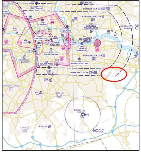
Figure 1 London City CTA
Pilot
The pilot reported that they had planned the route to fly from West Tisted in Hampshire to Rougham in Suffolk as follows:
- West Tisted – VOUGA (3NM ENE of West Tisted) – LUXIV (2NM west of Haslemere) -Biggin Hill Airport – Dartford – Chelmsford -Rougham (Figure 2)
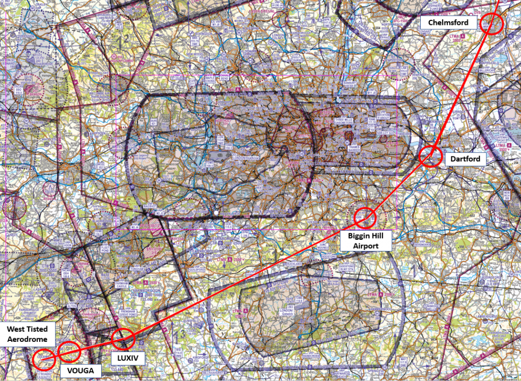
Figure 2 The planned route
The route had been planned on a VFR Moving Map and the pilot was also carrying a VFR 1:250,000 chart. The pilot was I was returning to Rougham from a short visit to West Tisted. To the south of Bordon, the pilot contacted Farnborough to obtain a Basic Service as they routed to the northeast and under the Farnborough CTA at between 1,800 and 1,900 feet. They routed slightly north of their track to maintain north of the Gatwick CTA ( base 1,500 feet) . In the vicinity of Epsom they were transferred to Biggin Approach and were issued a squawk and placed under a Basic Service. The route was the same as that completed earlier in the day (in reverse) with no issues. On passing north abeam Biggin Hill Airport, the pilot was directed to call when passing Swanley. The pilot’s concentration was, at that time, focussed on identifying Swanley from their chart when they received an audible warning from their VFR Moving Map that they were infringing the London City CTA. At the same time, Biggin Approach called and directed them to turn to the east immediately. The pilot had had already begun to descend quickly and they also turned to the East. On reaching 1,300 feet, the pilot turned back toward Dartford and completed, uneventfully, the remainder of the flight.
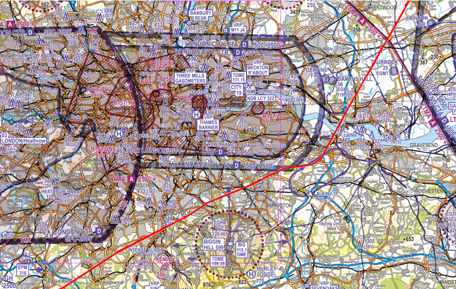
Figure 3
Findings and Causal Factors
This infringement resulted from 2 main factors when transiting in complex airspace near 4 London airports and the busy GA aerodrome at Redhill. The first aspect was the Human Factor of Cognitive Tunnelling. This occurs when the brain is involved in the processing of highly critical task-relevant information, with limited or no processing of secondary information that may also be important to the task. In this case, the pilot was focussing on trying to visually locate Swanley and did not see the relevant data that was a being displayed on their VFR Moving Map which would have been the displaying of a visual alert as to the proximity to the London City CTA , the physical position of the aircraft on the Moving Map and the audio alert associated with the proximity warning. This type of human factor is common in many airspace infringements when operating in the single-pilot mode that underpins the majority of Sport and Recreational GA flying where Crew or Team Resource Management cannot be employed as a defence. In addition, in many infringement occurrences where Moving Maps are used, pilots often report a failure to hear alerts. Whilst in some cases this may be due to the equipment’s audio alert being masked by engine noise, it is also possibly due to a degradation in hearing during stressful situations. At times of heightened stress, hearing can be degraded as the adrenaline produced by the body in response reduces or even stops circulation in the inner ear.
The second aspect was much more associated with lapses in Threat and Error Management in the planning stage and related to the route selected. The pilot, whilst using a VFR Moving Map to enhance situational awareness, was faced with a complex 107NM route. The first 55NM (to the point of the airspace infringement) included a large number of Threats associated with airspace structures that either had to be avoided or subject to obtaining a clearance/permission to enter. In addition, in the relatively narrow corridor between the London/London City and Gatwick controlled airspace, there is a latent Threat posed by other aircraft in relation to mid-air collision. The numbers in the list below relate to those plotted on Figure 4.
- Farnborough CTA-4 with a base of 2,500 feet (LTMA directly above).
- Gatwick CTA with a base of 1,500 feet (LTMA directly above).
- Heathrow CTR -Gatwick CTA corridor with potentially high volumes of other aircraft in a relatively narrow, low volume of Class G airspace with the LTMA directly above from 2,500 feet. This area is frequently used by traffic to/from Redhill, Fairoaks and Biggin Hill including instructional flights and those by solo-students where workload affects lookout.
- Kenley Gliding Site with winch launching to 2,600 feet amsl.
- Warlingham (Kennel Farm) Hang-gliding with winch launching to 2,600 feet amsl.
- Biggin Hill ATZ.
- Biggin Hill IAP laying outside controlled airspace (annotated by the ‘feathers’ on the chart) and
- London City CTA with a base of 1,500 feet (LTMA directly above).
When considering a route, it is essential that effective Threat and Error Management is incorporated into the plan. By avoiding the Heathrow CTR – Gatwick CTA corridor and routing from:
- West Tisted – Petersfield – Burgess Hill – Uckfield – Tunbridge Wells – The QEII Bridge/Dartford
and incorporating the guidance of ‘Take 2’, the pilot would have added a maximum of just 17NM to the overall flight distance and approximately 10 minutes to the flight time but would have Treated (managed) all 8 Threats shown in Figure 4.
It is very difficult to know exactly where you will become distracted; none of us have the benefit of foresight but with effective TEM, one can anticipate when you may succumb to increased workload, heightened stress and a greater risk of distraction. Hindsight? No; active TEM? Yes. By looking at the chart extract in Figure 4, one can see that that the 30NM section from abeam OCKHAM VOR (OCK) to the River Thames will stretch even the best pilot’s lookout and capacity.
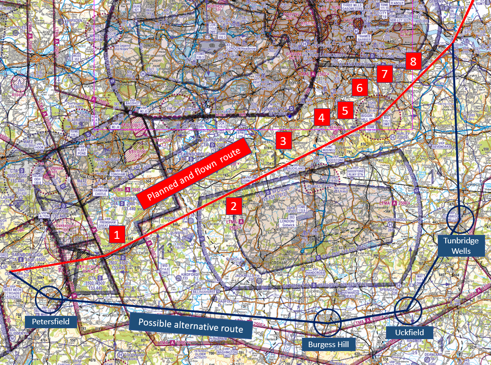
Figure 4
Focus on
- Threat and Error Management – Read Threat & Error Management
- Use of Moving Maps – ‘alert fatigue’ and use of climb/descent waypoints.
- Take 2 – Read TAKE2
Infringement of the Class D Newcastle Control Area (CTA)
| Aircraft Category | Fixed-wing SEP |
| Type of Flight | Recreational |
| Airspace / Class | Newcastle City CTA / Class D |
Met information
- METAR EGNT 231350Z 10007KT 070V160 CAVOK 18/M01 QNH 1028
- METAR EGTC 231220Z 12010KT 070V160 CAVOK 15/01 QNH 1028
Air traffic control
The Air Traffic Controller observed a 7000 squawk on radar with MODE S in the vicinity of Sunderland Harbour routing northbound indicating 2,000 feet. As the aircraft approached Tynemouth it was seen to have commenced a descent to 1,600 feet. A blind call was made to try to establish contact and intentions, but no reply was received. As the aircraft continued north and approaching the Blyth windfarm it was observed to climb to 1,800 feet. Further blind calls were made to the aircraft with no response. The aircraft left the CTA and was observed climb to 4,000 feet and was tracked on radar to the Scottish borders where the contact was lost. Scottish FIR was asked to maintain vigilance in case the aircraft made contact. Scottish FIR called back to confirm that no contact had been made. There was no impact on operations at Newcastle Airport throughout period of infringement.
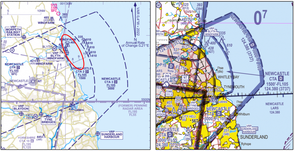
Figure 1
Pilot
The pilot reported that they had planned to fly from Cranfield aerodrome in Bedfordshire to an aerodrome in southeast Scotland having collected a family member. The route had been planned on a VFR Moving Map as follows:
Cranfield – Sackville Farm – Stilton – The Wash –Sunderland Harbour – 5NM northeast of Morpeth – Scotland.
The route was intended to be flown at around 165 knots with a climb to 5,000 feet until approaching Newcastle. As the passenger was not keen to fly over water, the pilot intentionally planned to fly under CTA-2 to be closer to land followed by a climb up to around 3,000 feet before starting a final descent into their destination aerodrome. The route was selected to route to the east of the military aerodromes in Lincolnshire, to the west the military danger areas of Holbeach (EG D207) and Donna Nook (EG D307) and to the west of the Teesside CTR/CTA before turning left for the destination once north of the Newcastle CTA. The pilot stated that is was a route that they were very familiar with and commented that, on the return flight from Cranfield in the middle of afternoon, it was very thermic. As they approached Newcastle and heading out to sea they descended to route beneath the higher CTA-3 (with a base of 3,000 feet) and then again to route beneath CTA-2. At that point they started to experience thermic activity. The pilot commented that as they approached the offshore wind farms at Blyth they were being “pushed up slightly”; they were, however, unaware of the infringement. They also added that it was possible that the QNH at Newcastle may have been different to that set as they were still flying on the QNH issued for their departure at Cranfield (180NM to the south).
The pilot did not plan to communicate with air traffic control along the route and while they did consider contacting Newcastle to request a CTR transit overhead they decided against it as they didn’t want to inconvenience them.
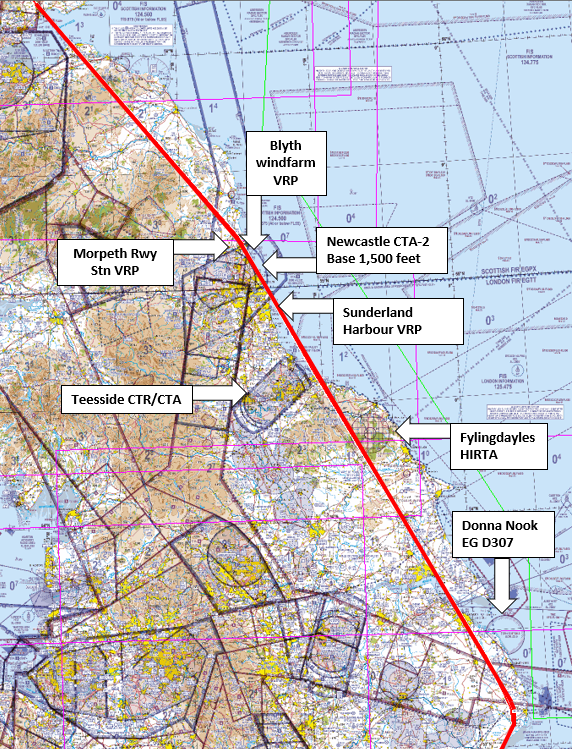
Figure 2
Findings and Causal/Human Factors
The infringement occurred due to an inadvertent climb into the CTA due to thermic activity. Whilst the pilot reacted quickly to the climb, the response was insufficient to prevent the aircraft entering controlled airspace. However, a number of valuable lessons emerged from this occurrence. Many of the lessons that might be learned from occurrences can be relevant to us all and often may not be new.
Threat and Error Management
One way of learning from occurrences offered within the ASI narratives is to view them in the context of Threat and Error Management (TEM) which is an essential part of the planning and preparation for every flight, whether it be a local flight or a cross-country landaway. So what were the key Threats to this flight?
Threats
Airspace
The pilot flying the circa 300 NM route from Cranfield to Scotland had to consider a multituide of airspace structures en-route, including Class D CTA’s and CTR’s, active Danger Areas, Aerodorome Traffic Zones (ATZ’s), Military Aerodrome Traffic Zones (MATZ’s) as well as winch launch glider sites, unlicenced minor aerodromes, parachute sites and unusual aerial activity tactically notified on the day by NOTAM. The pilot was using a VFR Moving Map which not only would have given the pilot enhanced situational awareness as to their location but also timely alerts to airspace and notifies unusual aerial activity. When planning for the flight, it is good practice to also plot the route on a paper chart. By doing this, a “single view” of the route and airspace is available, more than when ‘rubber banding’ the route electronically between waypoints. In addition, having a chart ‘marked-up’ acts as a perfect mitigation to the Threat of a tablet or display failure when solely relying on a VFR Moving Map. It is also possible to print out a “route chart” from some moving map software (on a long route this can be several pages). Having backup electronic moving map devices available, provides additional threat management. Having an alternative chart available (in whatever form – electronic or paper), mitigates the threat of the failure of a primary use VFR Moving Map.
Distraction
Any time that you fly with a passenger, irrespective of who they are and how many times they have flown before, they need to be managed to ensure that they do not pose a distraction from the priority tasks of aviate, navigate and communicate. In this situation, the pilot knew that the passenger was nervous when flying over water, so this needed to be considered, as the pilot’s attention may be drawn towards providing reassurance and away from the various tasks of operating the aircraft.
Weather
In this particular case the pilot was fortunate that the QNH values for the both Cranfield and Newcastle were the same for the duration of the flight; however, this is not a usual situation. As we all know, weather conditions often vary across the UK day by day and hour and by hour. Together with temperature, cloud and visibility, changes in air pressure (QNH) also occur. Such differences in QNH can be experienced especially when areas of low-pressure approach and transit the UK but can also occur when areas of high pressure build near to the UK. In general, if strong surface mean winds occur this is a sure sign of large pressure gradients which can result in large changes in pressure across Altimeter Setting Regions (ASRs). Typically, in this case in April differences in QNH of up to 10 hPa between two ASRs can be experienced (this represents a difference in altitude of ~ 270 feet). Although such significant differences in QNH are infrequent, when they do occur and the pilot hasn’t kept altimeter settings up-to-date, the implications can be significant in terms of the awareness of the height the pilot should be flying at and therefore presents a potential significant risks with respect to maintaining separation from and avoiding infringement of particular airspace, and also terrain clearance. So, in such conditions of changing QNH, particular care should be taken to ensure altimeter settings are up to date and relevant for the base of controlled airspace that is being operated underneath, i.e. Is the airspace above the route in reference to a QNH or a Flight Level and is your altimeter set correctly, to reflect this?
Version 3 of the Skyway Code (CAP1535) provides a very helpful description of the types of altimeter settings and altimeter setting procedures, (pages 86 and 87) and guidance to pilots on avoiding air infringements with respect to altimeter setting (page 132): ‘When considering your altitude also ensure that you are on the most appropriate altimeter setting for the area in which you are flying. Remember that the Regional Pressure Setting offered by some ANSP is the lowest forecast pressure setting for an altimeter setting region. Care must also be taken to note where the base of CAS changes between an altitude and a Flight Level.’
Examples of large pressure gradients over the UK created by both nearby low pressure and high-pressure systems in springtime (and therefore large differences in pressure between ASRs) can be found below. In these cases, the pressure gradients are basically north-south, but pressure gradients could be aligned in any direction to create large QNH differences across some ASRs.
Low pressure example: 11 April 2016, pressure varying from about 1008 hPa in south Barnsley ASR to just over 1016 hPa in north Tyne ASR (Figure 3).
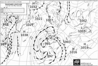
Figure 3
High pressure example: 29 March 2020, pressure varying from about 1036 hPa in south Barnsley ASR to just over 1046 hPa in north Tyne ASR (Figure 4).
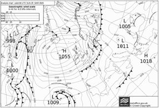
Figure 4
Complacency
This was route flown by the pilot on many previous occasions. It is possible that the practice of flying this route had become a routine task and therefore, a general relaxation of vigilance may have crept into their human performance and signals of Threats may have missed. An indication of this is that the pilot was unaware of the infringement indication; it is also possible that they only saw, on the aircraft instruments, what they expected to see. Every flight should be treated as if it is the first time that the flight is being made, from planning through to execution; the weather, NOTAM and traffic situation are but a few external factors that will vary each time along with human factors that affect performance.
Mitigations
Obtain a Crossing Clearance
The pilot could have mitigated the risks of an airspace infringement and of a nervous passenger becoming more distressed by low-level turbulence, by maintaining their initial altitude and requesting a VFR transit of the CTA and CTR.
‘Take 2’ (or more)
One method of avoiding advertantly infringing airspace is to provide an element of separation from controlled airspace; this can be achieved by incorporating the Take 2 guidance into the plan (where possible, maintain 2NM laterally or 200 feet vertically clear of notified airspace). However, in certain circumstances, it may be sensible to increase that distance based on a number of factors such as thermic activity, the speed of the aircraft and how easy it has been previously in the flight to maintain straight and level flight. However, when attempting to transit below a CTA with a low base, it is also important to consider unintended consequences of descending to fly lower. When flying with a nervous or apprehensive passenger, the act of flying lower and potentially into more turbulent air, an already concerned/apprehensive passenger may become more distressed leading to even greater distraction for the pilot.
Use a Frequency Monoitoring Code (FMC)
If the decision remained to fly below the CTA and ‘Taking 2’, it would have been good practice to use the relevant FMC for the area (in the case of Newcastle it is 3737 and Newcastle Approach on frequency 124.380 MHz) rather than squawking conspicuity. Whilst pilots will not be in receipt of any service under UK FIS, the use of an FMC helps in preventing and mitigating the consequences of airspace infringements. This works by allowing the ATSU to be aware of aircraft that are on their frequency and enables it to quickly contact the pilot of any aircraft that may be infringing (or are likely to infringe if capacity permits) controlled airspace, thereby allowing an actual or potential infringement efficiently to be resolved quickly, before it becomes a more serious incident. Subject to workload, ATC will often endeavour to provide a timely warning if an aircraft looks like it will infringe but there can be no guarantee that pilots will always be warned if controlling capacity does not permit. A chart of the FMC areas is in the UK AIP at ENR 6-80 and in AIC Y085/2020; Both the CAA 1:500k and 1:250k VFR Charts have the relevant frequency and FMC annotated on the chart and in addition, some VFR Moving Map apps provide that information on the display/radio tab. Even if your aircraft is not equipped with a transponder, it remains good practice to monitor the relevant frequency if an air traffic service is not requested as ATC will make ‘blind transmissions’ to aircraft that they believe may be infringing.
Focus on
- Threat and Error Management – Read Threat & Error Management
- Weather – Threat and Error Management – Read Weather – Threat and Error Management (Pre-flight planning 05)
- Use of Moving Maps – ‘alert fatigue’ and use of climb/descent waypoints.
- Take 2 – Read TAKE2
- Frequency Monitoring Codes – Read Listening Squawks and AIC Y085/2020
- Human factors – Read The Human Factors “Dirty Dozen” (SKYbrary)
- Read The Skyway Code
Infringement of the Class D Stansted Control Area 2 (CTA-2)
| Aircraft Category | Fixed-wing SEP |
| Type of Flight | Recreational |
| Airspace / Class | Stansted CTA / Class D |
Met information
- TAF EGSS 031056Z 0312/0418 24008KT 9999 SCT035
TEMPO 0405/0418 7000 -RA
PROB30 TEMPO 0406/0413 3000 +SHRA BKN014
PROB30 TEMPO 0413/0418 SHRA RA BKN014= - METAR EGSS 031520Z AUTO 24008KT 9999 NCD 23/13 Q1019=
Air traffic control
The Air Traffic Controller observed a 7000 squawk on radar enter the southern part of the Stansted CTA near Epping indicating 2,200 feet. As the aircraft entered the CTA the Controlled Airspace Infringement Tool (CAIT) activated triggering an alert. The aircraft was seen to track northwest and then west, before leaving controlled airspace to the west of North Weald. The aircraft was then seen to squawk 5024 (Farnborough LARS North) and the pilot obtained a Basic Service. There was no impact on operations at Stansted Airport throughout period of infringement.
This incident took place when there has been a large decrease in the amount of Commercial Air Transport traffic operating at Stansted Airport and consequently there was no impact on the operation at Stansted. However, as traffic levels start to increase at airports a similar infringement would likely to result in disruption to arrivals or departures.
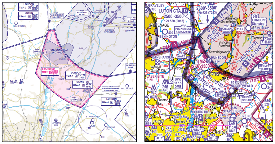
Figure 1
Pilot
The pilot reported that they had planned to fly a return flight from Stapleford to practise navigation using VFR chart and dead reckoning, ahead of a future training course. The route (Figure 2) had been planned with turning points at: Cheshunt – Top Farm airstrip – Bassingbourn disused – Barkway VOR (BKY) – Panshanger disused
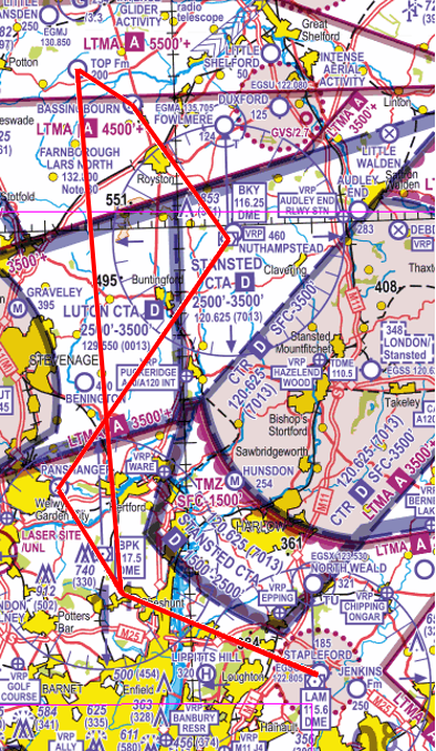
Figure 2
The route had been chosen as such as they were points of interest for a future CPL course. The flight was also to take a passenger flying who had never been in a light aircraft before; the passenger had a history of motion sickness experienced in other forms of transport.
On lining up on the runway the pilot carried out a check of the Direction Indicator but failed to correct a 5O error. The route planned started with an overhead departure from Stapleford. After departure from Runway 21L, the pilot followed the left-hand circuit and established a climb on the downwind leg. Shortly after turning downwind, the aircraft ahead in the circuit reported that they were returning to Stapleford for an immediate landing due to a low oil pressure indication. At the time there was an aircraft already on final and another aircraft late downwind nearing the base leg turn making a total of 4 in the circuit. The pilot of the subject aircraft decided the safest course of action was to continue climbing on the downwind leg and delay the turn overhead onto the planned heading of 290O for Cheshunt, and be at / above 1,800 feet when crossing the final approach path. This resulted in the turn onto the planned heading occurring approximately 1NM further northeast than planned, the turn itself was a gentle turn with 10O angle of bank, due to turning in the climb. The result of the two actions, lead to a track error of 0.6NM, with the actual track offset to the northeast, towards controlled airspace.
At the top of the climb, the pilot completed the after-take-off checks. These included a gross-error check of the route and heading where the pilot noted that ground features were seen as expected. During the checks the pilot noted that the passenger had been unusually silent since take-off. The pilot became concerned about their wellbeing and questioned how they were feeling, to assess if an immediate return to Stapleford would be required. The distraction led the pilot into failing to note and correct the offset actual track, caused by the late turn, and failing to correct the error in the DI. The pilot also recalls the wind appeared stronger than forecast, leading to a further 10o track error. Due to these errors, the pilot inadvertently entered CTA-2 one minute after the top of climb, south of VRP Epping.
After checking if the passenger was ok, the pilot noticed that the picture, particularly the aircraft’s position relative to North Weald didn’t look correct. The pilot referred to their VFR Moving Map which was under their PLOG and noticed that they had infringed the Stansted CTA. As the aircraft was now close to the south-eastern boundary of the CTA, the pilot turned the aircraft onto a heading of 225oM to leave the CTA as quickly as possible whilst at the same time commencing a descent to increase groundspeed and expedite the exit of controlled airspace. (Figure 3)
Throughout the initial phase of flight, the pilot was communicating with Stapleford Radio due to still being in their ATZ.
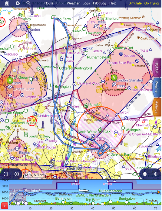
Figure 3 Planned and Actual Tracks (entire Flight) in SkyDemon
Findings and Causal/Human Factors
The pilot carried out a detailed post flight analysis to the CAA as part of their MOR submission by reviewing the events leading up to the occurrence in terms of Threat and Error Management. In it they commented that they were previously unaware of the Take 2 guidance and noted that their initial planned tract was close to the CTA and “did not allow enough margin for error”. The track planned for this flight was within 1NM of Stansted’s CTA 2. It would have been beneficial to have a more prominent landmark for the first turning point that would have made visual navigation easier. A less complex departure from Runway 21 could have been to climb straight ahead, considering noise abatement, and then turn to the River Lea reservoirs, this would allow a greater margin from controlled airspace in addition to using a more visible reference.
The pilot also reflected on how they now consider that there were too many aims and objectives for this flight, which unnecessarily increased their workload. Reflecting on the event, the aims of this flight could have been covered across two or three flights. Flying with passengers always introduces the threat of distraction and increased workload; this is heightened with one that has the potential to be unwell. In such circumstances, a simple route planned to minimise proximity to controlled airspace might give the pilot more capacity to provide reassurance and explanation of what is taking place during the flight and possibly result more enjoyable flight for the passenger.
Although current, the pilot also believed that skill-fade, and therefore reduced capacity, caused by the lockdowns and effect of the COVID-19 pandemic also was a contributory factor in this incident. Throughout the pandemic, most of their flying was focused practising visual circuits.
The pilot, on reflection, added that the first time practising the use of navigation using dead reckoning than a VFR Moving Map, after the most recent lockdowns, could have been conducted with a qualified instructor or fellow PPL pilot in the right-hand seat, rather than with a non-pilot passenger. An element of complacency may also have been evident. The circuit for Runway 21LH was the one most flown by the pilot and therefore the one with which they were most familiar with. However, due to a recent change to widen the Runway 03 downwind leg further to the northwest, the pilot has recently flown that as part of a ‘club check flight’. Having not flown much due to COVID-19 related restrictions, this recent flight led to the ‘familiar’ picture developing when in proximity of the M25/M11 motorway junction along with a false sense of margin from the CTA when conducting the gross-error check at top of climb and in the vicinity of that reference point. All the pilot’s formal training was to east or south of Stapleford, most noticeably over Kent and Essex, and most of cross-country flying done since obtaining their licence the pilot had been accompanied by a qualified pilot. The pilot felt when flying to a new area it could have been advantageous to be accompanied by a fellow PPL Pilot familiar with the points of interest and route.
Summary
Threat and Error Management
The pilot was faced with many threats such as distraction from both within the aircraft and from aircraft in the visual circuit, skill fade and normalisation from the majority of their recent, COVID-affected flying being in the circuit environment to the reciprocal runway from that in use on 3 June 2021. Based on the proximity of the Stansted CTA and (although not a factor in this case, still a latent threat) North Weald operations, active TEM in the planning stage would have led the pilot to depart the Stapleford aerodrome environment as expediently and simply as possible through a southwesterly departure from Runway 21 with a turn to cross the M11 between Junctions 4 and 5 and then to the the River Lea thereby offering maximum separation from the Stansted CTA to the north and the London City CTA to the south.
However, once the decision was made to depart from the overhead, based on the developing traffic situation and increased workload from a rapidly changing plan, a reversion to using their VFR Moving Map may have offered the vital cues as to not only the proximity of controlled airspace but also as to the error in the, misalignement, albeit minor, of the DI. Once clear of the ATZ and established on a heading for Cheshunt, the pilot could then have reverted to Dead Reckoning navigation with very little impact on their training objectives.
Thanks go to the pilot for providing such a comprehensive report into this occurrence. Not only did they submit a report in the form of the online questionnaire at https://airspacesafety.com/infringement/infringement-form/ but they provided the detailed report above on their lessons identified for the benefit of learning and development.
Focus on
- Threat and Error Management – Read Threat & Error Management
- Use of Moving Maps – ‘alert fatigue’ and use of climb/descent waypoints.
- Human factors – Read The Human Factors “Dirty Dozen” (SKYbrary)
- Read The Skyway Code
Class D Newcastle Control Areas (CTA-4 and 5)
| Aircraft Category | Fixed-wing SEP |
| Type of Flight | Cross Country Recreational |
| Airspace/Class | Newcastle CTA-4 and CTA-5 / Class D |
Air Traffic Control
The Air Traffic Controller observed an aircraft on radar 4NM to the southwest of Derwent Reservoir squawking 7000 and indicating 3,500 feet heading towards Control Area 4 (CTA-4) (Figure 1). The controller made two blind calls to the aircraft in an attempt to establish 2-way communications to prevent an airspace infringement. Two minutes later the aircraft entered CTA-4 (Figure 2) without a clearance indicating 3,300 feet. The aircraft then continued on its track and entered CTA-5 indicating between 3,300 and 3,500 feet on Mode C; the aircraft left controlled airspace 3 minutes after first entering where the base of CTA-6 is higher at 4,500 feet AMSL. As the aircraft appeared to be heading towards Fishburn aerodrome, a second controller contacted the aerodrome; the Fishburn Air Ground Communication Service (AGCS) stated that they would get the pilot of the aircraft to contact Newcastle Radar. The pilot then called on the frequency and, on landing, also contacted the Watch Manager to explain that they had selected the Fishburn QFE and believed that they were at 2,800 feet. At the time of the occurrence, the Newcastle QNH was 1019 hPa.
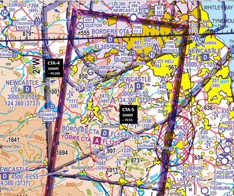
Figure 1 (Chart extract from Sheet 2171AB Northern England and Northern Ireland Edition 46 (2023)
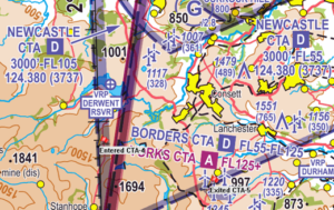
Figure 2 Chart extract from Sheet 2171AB Northern England and Northern Ireland Edition 46 (2023)
Pilot
The pilot reported that they had recently relocated their aircraft and flying operations to Carlisle Airport and had planned to fly a return flight to Fishburn for local area familiarisation with another pilot flying in the right-hand seat. When flying with a passenger who was a pilot, the passenger would carry out all radio communications. The route (Figure 3) had been planned to fly direct from Carlisle Airport (EGNC) to Fishburn Aerodrome at a maximum altitude of 2,800 feet AMSL to fly below the Newcastle CTA-4 and CTA-5 with bases of 3,000 feet AMSL. The route and weather planning had been carried out solely using a VFR Moving Map application; no reference had been made to the UK Met Office Website for meteorology information such as the GAMET and MetForms 214 and 215. A telephone call to Fishburn was made about an hour before departure to ensure the aerodrome was open and obtain the local weather.
On engine start the pilot was unable to establish communications with the Carlisle AGCS operator so they set the altimeter to zero to obtain an approximate QFE; the weather at Carlisle was good and posed no challenges. As the pilot approached the mid-way point of the flight, they encountered some cloud on the higher terrain to the south of Derwent Reservoir, so they deviated their route slightly to the north of their planned track (see Figure 3); this route deviation still took them underneath the same airspace that they had planned to route under (Newcastle CTA-4 and CTA-5).
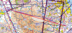
Figure 3 Chart extract from Sheet 2171AB Northern England and Northern Ireland Edition 46 (2023): Red line – planned track Purple line – approximate flown track.
Cognisant of the different weather in their vicinity to that on departure, the pilot-in-command asked the passenger to contact Fishburn AGCS to obtain the conditions at the aerodrome. On initial contact Fishburn Radio issued a QFE of 1006 hPa; the pilot set 1006 hPa on the altimeter subscale and adjusted to fly at 2,800 feet. On being advised that the weather at Fishburn Aerodrome was good, the pilot elected to continue to their destination. The pilot was then asked by Fishburn Radio to contact Newcastle Radar at this point they were issued with a QNH of 1019 hPa which, when set, increased their altitude by 400 feet meaning that they were no longer below the CTA as they thought they were.
After landing, the pilot contacted Newcastle Air Traffic Control by telephone and discussed what had occurred. The pilot was recommended, in future, to contact Newcastle Radar to obtain an Air Traffic Service which would also enable them to obtain the correct altimeter setting.
Findings and Causal/Human Factors
The pilot climbed into the Class D CTAs without a clearance when they set the Fishburn Aerodrome QFE on 1006 hPa and then adjusted the aircraft’s altitude back to their planned en-route altitude of 2,800 feet. Assuming a relationship of 1 hPa equating to approximately 30 feet, when a lower pressure by 13 hPa lower was set, the pilot would have climbed approximately 400 feet to adjust back to an indicated 2,800 feet. However, with the controlled airspace datum being the Newcastle QNH of 1019 hPa, the pilot climbed above the base of controlled airspace:
2,800 feet on 1006 hPa = circa 3,200 feet on 1019 hPa.
The Pilot carried out post-flight analysis and noted a few slips in how they planned and managed the flight. As is the case in most aviation occurrences there was not a single cause, and the chain of events can be taken back to the very start of the flight. Several contributory factors led to how the infringement developed as follows:
- Departing Carlisle Airport with the QFE set. The pilot identified that a more relevant altimeter setting to use on departure would have been the Carlisle QNH. In the absence of the AGCS operator to obtain an accurate QNH from, the pilot could have set their altitude to 190 feet thereby providing a relevant and fairly accurate QNH.
- Insufficient Met Planning. In the planning stage the pilot did not refer to any regulated meteorological information from the UK Met Office website such as the MetForm 215 and GAMET, relying instead solely on their VFR Moving Map application. However, pre-flight they noted that there was no cloud between Carlisle and Fishburn (most likely as neither departure nor destination aerodromes provide METARs and there were no such aerodromes along the route. In addition, the pilot did not refer to the ‘Flyable Conditions’ overlay that is provided with their application. Had they referred to the GAMET and MetForm 215 they would have noted that at the time of the flight, there was forecast isolated scattered/broken Cumulus and Stratocumulus cloud with a base of between 1,500 and 2,500 feet and a ceiling of up to 5,000 feet on the higher ground in the area. On a positive, the pilot telephoned Fishburn aerodrome about an hour before departure to ensure they were open and get the weather.
- Cockpit Distraction/Team Resource Management. When the pilot encountered the enroute weather, they asked their passenger to establish communications with Fishburn ACGS to check if the weather conditions at the aerodrome had changed since their earlier telephone call. The early radio call en-route was to check that the weather had not changed due to the cloud that they were encountering enroute. However, in also monitoring the frequency, the pilot set the QFE too early. By having clear task delineations, albeit in a single pilot operation, there is also a reduced risk of distraction.
- Decision not to use the Newcastle Frequency Monitoring Code (FMC). When operating proximate to controlled airspace, it is recommended that pilots be in receipt of an Air Traffic Service. In the area in which the pilot was flying, Newcastle is the nominated LARS unit to a range of 40NM on frequency 124.380 MHz (UK AIP ENR 1.6.4 refers). However, as the pilot elected not to obtain an air traffic service, rather than operating autonomously and squawking 7000 or 2000, they could have made use of the relevant FMC. In the case for Newcastle the frequency is 124.380MHz and the squawk is 3737 (this information is annotated on the VFR chart at the boundary of the relevant airspace and in AIC Y111/2023). In this occurrence, the Air Traffic Controller made two blind calls to the aircraft to establish 2-way communications to prevent the infringement.
Summary
The pilot found themselves distracted from their initial plan due to encountering some en-route weather which then led to a simple deviation from that plan. Sometimes it is easy to assume that the good weather at the departure aerodrome will, on a 50NM flight, not pose challenges enroute. However, the UK’s climate can lead to a changeable weather picture with localised weather and microclimates. Detailed planning using regulated aeronautical and meteorological information will enable all Threats to be identified and mitigated pre-flight allowing the flight to be safe and enjoyable with the pilot having greater capacity during the flight to deal with the unexpected.
Focus on
- Threat and Error Management and Pre-flight Planning and Preparation
- Lower Airspace Radar Service
- Frequency Monitoring Codes
- Newcastle FMC guide
- VFR Moving Map Devices (CAA Safety Sense Leaflet 29)
- European General Aviation Safety Team, Safety Promotion Leaflet, Using Advanced Navigation Technology Safely
- Distraction and Interruption (CAA Safety Sense Leaflet 31)
- Newcastle ATC – Avoiding Airspace Infringement
Class A Cotswold Control Area (CTA-13)
| Aircraft Category | Fixed-wing SEP |
| Type of Flight | Cross Country Recreational |
| Airspace/Class | Cotswold CTA-13 / Class A |
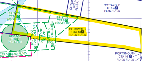
Extract from UK AIP ENR 6-7 (Chart of UK ATS Airspace Classifications )
Meteorology
Departure aerodrome: Exeter EGTE
TAF EGTE XX0727Z XX07/ XX15 23011KT 9999 SCT025
BECMG XX07/ XX10 33014KT
TEMPO XX07/ XX12 6000 SHRA
PROB30 TEMPO XX07/ XX13 34016G26KT
PROB30 TEMPO XX07/ XX10 4000 +SHRA BKN014=
Closest to arrival aerodrome of Sturgate EGCS: Waddington EGXW
TAF EGXW XX0744Z XX09/ XY03 999 BKN030
PROB30 TEMPO XX09- XX12 SCT010
PROB30 TEMPO XX12/ XX15 SCT018=
Air Traffic Control
The air traffic controller at the London Area Control Centre reported that they observed an aircraft climb into Cotswold Control Area 13 (CTA-13) indicating FL106 and then FL107 where the base of controlled airspace is FL105. Radar images illustrate that the aircraft had entered CTA-13 approximately 4NM northwest of Keevil Gliding Site (see below Figure 2). The aircraft was then observed to squawk 5050 (Bristol Radar Basic Service conspicuity code) so the controller contacted Bristol Radar by telephone to understand the aircraft’s intentions. The Bristol Radar controller explained that the aircraft had recently established two-way communications with them to obtain a service and that the pilot had reported operating at FL102, below the base of controlled airspace. The Bristol Radar controller informed the pilot that they were inside controlled airspace and instructed the pilot to descend. The aircraft left controlled airspace by descent.
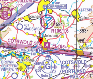
Extract of NATS CAA 1:500,000 Sheet 2171CD Southern England and Wales Edition 49 (2023) including the GPX trace from the pilot’s VFR Moving Map device.
Pilot
The pilot reported that this flight was planned between Exeter, Devon to Sturgate in Lincolnshire to attend a business meeting. Pre-flight planning had been primarily conducted using a VFR Moving Map platform, which was used to plan the route and access NOTAM and meteorology information to inform the route planning. The Met Office Aviation Briefing Service, including Met Forms F214, F215 or GAMET was not used. The pilot was navigating using the VFR Moving Map device and was also carrying a NATS CAA 1:250,000 aeronautical chart.
The pilot reported that during the planning stage they had identified the route and would transit beneath the Cotswold CTA with a base of FL105; they had established from the forecast that there would be some cloud in the area which the pilot noted would be worse in the south and would improve as the flight progressed northbound. With regards to communications planning, the pilot planned to initially monitor the Bristol Radar frequency on 119.155 MHz and make use of the Frequency Monitoring Code (FMC) of 5077 whilst operating proximate to Bristol controlled airspace. This allowed the pilot to obtain the Bristol QNH of 992 hPa without contacting the unit to obtain a service.
Approximately 21NM after departure whilst approaching Taunton, the pilot noted a significant amount of cloud in the Bristol area and made the decision to climb above the cloud to remain in compliance with Visual Meteorological Condition (VMC) minima. This decision was influenced by the pilot’s preference to fly above cloud in particularly strong wind conditions as were present on this flight and, with consideration of the cloud overflown earlier in the flight, the belief that they would be able to descend back down below clouds in a short period of time. A climb was initiated, and the pilot monitored the altimeter ensuring it read below 10,500 feet to remain below the CTA; the altimeter subscale was still set to the Bristol QNH of 992 hPa. The pilot also referenced the vertical display on the VFR Moving Map device which also depicted the aircraft below the base of controlled airspace.
The pilot was contacted by Bristol Radar and informed of the infringement. Due to the developing cloud, the pilot routed southbound on a reciprocal track in search of a gap in the clouds and descended outside of controlled airspace (See Figure 3 below). This pilot did not hold the required Instrument Rating(s) to fly within Class A airspace and therefore a clearance to continue could not be provided.
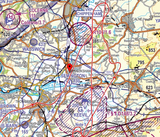
Extract of NATS CAA 1:250,000 Sheet 8 England South Edition 27 (2023) including the GPX trace from the pilot’s VFR Moving Map device.
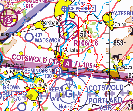
Extract of NATS CAA 1:500,000 Sheet 2171CD Southern England and Wales Edition 49 (2023) including the GPX trace from the pilot’s VFR Moving Map device.
Findings
The pilot initially made the decision to climb as they believed they could transit above the clouds ahead whilst remaining in compliance with VMC minima. The pilot believed they were operating outside of controlled airspace at the time as the aircraft altimeter which was set to 992 hPa indicated less than 10,500 feet. Assuming a relationship of 1hPa equating to approximately 30 feet, as the altimeter subscale was set to a QNH 21 hPa lower than the Standard Pressure Setting of 1013 hPa, the aircraft was operating approximately 630 feet higher than the altimeter read (21 hPa x 30 feet = 630 feet). Therefore, the base of CTA-13 at FL105 on the Bristol QNH equated to approximately altitude 9,870 feet rather than 10,500 feet AMSL as the pilot believed.
Causal and Human Factors
Insufficient pre-flight meteorology planning
During the planning stage the pilot had identified that they would encounter some clouds along the route using the meteorological information included in their VFR Moving Map platform – namely only Terminal Aerodrome Forecasts (TAFs) and Aviation Routine Weather Reports (METARs) along the planned route. It should be noted that TAFs indicate only the base of forecast cloud and provide no situational awareness as to the vertical extent of any cloud formation. This information can be decoded from the Met Form F215, which forecast at the time and location of the infringement (areas A, A1 and B1), scattered (3-4 Oktas) to broken (5-7 Oktas) Cumulus and Stratocumulus clouds with bases between 1,500 and 3,000 feet AMSL and ceilings between 5,000 feet AMSL and “XXX”( a level higher than the chart upper limit) and thus above 10,000 feet AMSL. In addition, it forecast the likelihood of encountering other conditions such as heavy showers and thunderstorms of rain or isolated embedded cumulonimbus clouds with the 0 degree isotherm forecast at 4,000 feet AMSL; the information in the Met Form F215 indicated that the pilot would be unlikely to safely climb above the cloud in this area whilst remaining both in compliance with VMC minima and outside of Class A airspace.
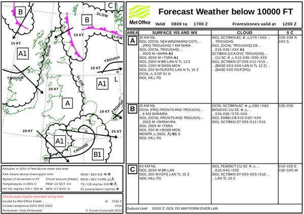
Met Form F215 applicable at the time of the infringement.
Climbing through the Transitional Altitude without setting the Standard Pressure Setting of 1013 hPa
The pilot did not consider changing the altimeter subscale on this flight as they had never flown above the Transition Altitude before. Whilst planning a flight that routes beneath or through airspace with a base defined as a Flight Level, it is recommended to make note of the Transition Altitudes along your route and set your altimeter to 1013 hPa to ensure vertical situational awareness in relation to the airspace boundaries. If your aircraft has two altimeters, both should be set to 1013 hPa to provide a reference to check if one reads erroneously. Transition Altitude in the UK is 3,000 feet except in, or beneath, airspace structures described in UK Aeronautical Information Publication (AIP) ENR 1.7 (4) (see below Figure 5)
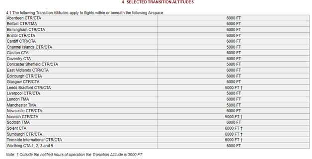
Extract from UK AIP ENR 1.7 (4) Selected Transition Altitudes
Insufficient use of regulated navigational materials leading to “Confirmation Bias”
The pilot conducted this flight using an unregulated VFR Moving Map application as the primary source of navigation with a NATS CAA 1:250,000 aeronautical chart as a “backup”. Due to the vertical limits of airspace depiction on this type of paper chart (5,000 feet AMSL), the pilot was reliant upon the VFR Moving Map device above 5,000 feet and could not refer to the paper chart for additional situational awareness. A NATS CAA 1:500,000 chart would have been more appropriate for the length of this route.
Altitude information depicted in VFR Moving Map products is GPS derived, therefore may vary in accuracy in comparison to the barometric altimeter. Such devices are currently unable to determine the barometric pressure during the flight and as a result do not vary the altitude at which airspace with a base defined in Flight Levels is depicted at. In this case, although the base of CTA-13 at that time was approximately altitude 9,870 feet due to the QNH of 992 hPa, the vertical display on the VFR Moving Map still depicted the base of CTA-13 as altitude 10,500 feet. As such, as the aircraft climbed above altitude 10,000 feet, the vertical display indicated the aircraft below the base of the CTA contributing to further confirmation to the pilot that the aircraft was outside of controlled airspace. The CAA encourages the use of VFR Moving Maps in planning and flying when used in conjunction with appropriate regulated resources and the effective application of Threat and Error Management (TEM).
Lapses in TEM due to a perceived pressure to fly
Perceived pressure to fly can lead to lapses in safe and effective decision making. The pilot was completing this flight to travel to a business meeting; it was perceived that non-completion of this flight could have led to a loss of income. In these “pressure to fly” circumstances, pilots can be more likely to make higher risk decisions than they usually would, for example deciding to continue and climb above significant cloud rather than turn around and abort the flight. In any stressful situation, humans can often become “task focused” to the detriment of considering other available information which can be used to make a safer decision.
Effective TEM can mitigate this; the Threat of poor weather could be mitigated by a thorough weather and route brief the evening before culminating in a Go/No-Go decision. If the weather for the following morning seems unconducive for a flight, the pilot can make alternative travel plans for the morning to ensure the meeting is attended on time.
Summary
The pilot climbed into the Class A CTA without a clearance whilst attempting to transit above cloud encountered along the planned route, this was underpinned by a perceived pressure to fly to attend an important business meeting that morning. The infringement was compounded by the pilot having not set the Standard Pressure Setting whilst climbing beneath airspace with a base depicted as a Flight Level and therefore hindering their situational awareness as to the aircraft’s position in relation to the CTA. Thorough and effective pre-flight preparation using regulated meteorological and aeronautical information would have indicated that weather conditions in the Bristol area were not favourable to flight and that flight along this route should not have been completed that morning.
It is sometimes easy to succumb to a perceived pressure to fly and to seek reasons and methods to complete a flight, rather than reasons not to. Detailed consideration of TEM pre-flight can enable a flight to be enjoyable and conducted safely or identify alternatives when that might not be possible.
Focus on
- CAA Infringement Tutorial
- Pre-flight Planning and Preparation – including weather and contingencies
- Lower Airspace Radar Service
- Frequency Monitoring Codes
- Bristol Area FMC Guide
VFR Moving Map guidance
Class D Birmingham Control Area 1 (CTA-1)
| Aircraft Category | Fixed-wing SEP |
| Type of Flight | Cross Country Recreational |
| Airspace/Class | Birmingham CTA-1 / Class D |
Meteorology
METAR EGBB XX0950Z 07014KT 9999 FEW029 13/07 Q1016
METAR EGBB XX1020Z 07015KT CAVOK 13/07 Q1015
TAF EGBB XX0732Z XX07/XX06 09011KT 9999 SCT011
TEMPO XX07/XX09 BKN011
TEMPO XX15/XX06 7000 RA SHRA
PROB30 TEMPO XX16/XX24 4000 +SHRA
BECMG XX18/XX21 16005KT
PROB40 TEMPO XX00/XX06 BKN008=
Air Traffic Control
The Air Traffic Controller observed an aircraft on radar in the vicinity of Lichfield Visual Reference Point (VRP) tracking southwest squawking a London Information squawk, 1177, indicating 1,800 feet. The controller used Mode S to establish the callsign of the aircraft. The Birmingham controller called London Information to ask for the aircraft be transferred to their frequency during which the Airspace Infringement Warning (AIW) alerted to the aircraft indicating 1,900 feet entering CTA-1 where the base of controlled airspace is 1,500 feet AMSL.
A Commercial Air Transport (CAT) aircraft that had previously been cleared for an ILS approach to Runway 15 was issued with traffic information on the infringing aircraft. Birmingham ATC is required to maintain separation of 5NM or 5,000 feet against unknown aircraft within their designated controlled airspace. An immediate loss of separation occurred between both aircraft with lateral separation reducing to 4.51NM. Avoiding action was believed to not have improved the situation; however, the CAT aircraft was given further vectors to ensure a safe approach was achieved.
The infringing aircraft then called on Birmingham frequency to pass their details and the controller informed them they had infringed.
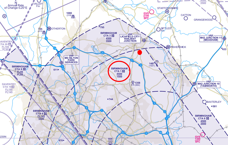
Figure 1: The aircraft entered the Class D CTA-1 indicating 1,900 feet where the base of controlled airspace is 1,500 feet AMSL.
Pilot
The pilot was on a VFR cross-country recreational flight from a private site at Ince Blundell in Merseyside to Stapleford Aerodrome. The flight had been planned and was flown with two colleagues in another aircraft following behind. There was no communication between the two aircraft throughout the flight.
The pilot had been carrying a CAA NATS 1:500,000 chart and was using a VFR Moving Map platform on an iPad; however, no airspace warnings had been configured and it was reported that turbulent conditions made the use of the Moving Map device difficult.
The pilot was in receipt of a Basic Service from London Information. When approaching Birmingham, London Information informed the pilot that their colleagues in the aircraft behind were diverting to Wolverhampton/Halfpenny Green Aerodrome. The pilot reacted and immediately turned towards the aerodrome not knowing why they had diverted. During the confusion, the pilot became distracted and had neglected to notice they were entering Birmingham CTA-1, believing to be underneath Birmingham CTA-3 where the base of controlled airspace is 3,500 feet.
For suggested actions, the pilot comments they should have remained calm to assess the situation and followed the ‘Aviate, Navigate, Communicate’ principle.
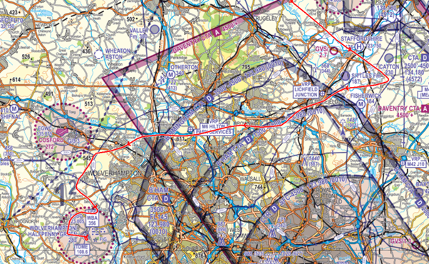
Figure 2: GPX trace represented on the CAA/NATS 1:250,000 chart.
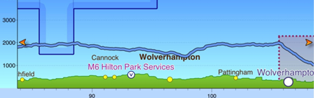
Figure 3: VFR Moving Map vertical depiction.
Findings and Causal/Human Factors
The pilot entered the CTA without a clearance when carrying out an unplanned diversion to Wolverhampton/Halfpenny Green Aerodrome on learning that the other aircraft in the party was diverting there. The pilot experienced a loss of situational awareness as to the airspace construct in relation to their position.
It was established that the event was underpinned by lapses in Threat and Error Management (TEM) and management of the flight in that insufficient planning took place prior to turning towards the new destination. The pilot was also in receipt of a Basic Service from London Information which was not the most appropriate Air Traffic Service available when operating close to Birmingham’s controlled airspace.
The pilot carried out post-flight analysis and commented on causal factors. As is the case in most aviation occurrences there was not a single cause. Several contributory factors led to how the infringement developed as follows:
Pre-Flight Planning
Route planning – The pilot conducted this flight using a VFR Moving Map and a NATS CAA 1:500,000 chart. Although the pilot had not intended to route beneath Birmingham controlled airspace, during the pre-flight planning stages, airspace proximate to the planned route should be studied and it is recommended to make a note on your chart or PLOG of airspace considered a Threat. It was positively commented that the pilot’s initial planned route was incorporating ‘Take 2’ (see later) from the boundary of Birmingham controlled airspace.
It is important to use regulated aeronautical information products from the NATS Aeronautical Information Service during pre-flight planning and preparation such as the most appropriate VFR charts and the UK AIP to ensure the most relevant and accurate information is available. The distance and altitude of your planned route will also determine the most relevant CAA NATS Chart to use. For example, for longer routes such as this one, it may be more appropriate to use the CAA NATS 1:500,000 chart to reduce pilot workload when having to refold and change chart mid-flight.
Contingency planning – The pilot reacted to the diversion immediately without sufficient consideration given to some in-flight re-planning. It is understood that an in-flight change may not always be predictable; however, suitable contingency planning should be considered at the pre-flight planning stages. In this case, a contingency plan should have been drawn up in the case of one aircraft needing to divert. There were no communications between the aircraft during the flight and had a contingency plan been incorporated into the pre-flight planning, the stress and anxiety of an unknown diversion may have been reduced along with the risk of infringing.
It is important for every flight to ensure a contingency plan has been made. This can include a plan in case of an aircraft emergency, weather avoidance due to unpredicted weather, passenger sickness etc. Ensuring you have a ‘Plan B’ will reduce the workload of the pilot, increase situational awareness and reduce the risk of infringing notified airspace.
Meteorology Planning – The pilot reported strong southerly winds and turbulent conditions on the day. A thorough weather brief using regulated information from the Met Office website, for example Met Forms F214 and F215, should be completed prior to every flight and associated risks incorporated into the planned route. Ensure to utilise your VFR Moving Map to cross-check your position to maintain situational awareness, and to help you remain on track and prevent an inadvertent drift towards controlled airspace. The F215 for the day of the flight forecast a cold front moving northeast towards the Midlands at 20 knots with isolated cumulonimbus clouds, scattered and broken cumulus and stratocumulus cloud with turbulence and some low-level stratus (Figure 4).
Pilots are advised to maintain adequate separation from notified airspace through the application of the ‘Take 2’ guidance (where able, plan to remain at least 2NM from the edge or 200 feet below the base of the subject airspace) to avoid airspace infringements. The recommended 200 feet distance may need to be increased during flights where turbulence or thermic conditions are encountered to prevent inadvertent climbs into controlled airspace.
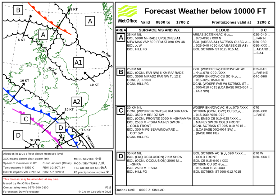
Figure 4: Met Form F215.
Threat and Error Management (TEM)
Air Traffic Services (ATS) – The pilot was in receipt of a Basic Service from the non-radar unit at London Information. When planning it is important to plan the most appropriate ATS along your route. In this case, when proximate to Birmingham controlled airspace, it is strongly recommended to request a service from Birmingham Radar on 123.980 MHz or to make use of the Birmingham Frequency Monitoring Code (FMC) by listening out on 123.980 MHz and squawking 0010. Had the pilot been in receipt of a service from Birmingham, Air Traffic Control (ATC) may have been able to intervene earlier to offer assistance which may have prevented the infringement.
To increase your chances of being issued with a prompt clearance to transit controlled airspace, it is essential that you plan your route, considering adjacent airspace, and prepare your radio transmissions in advance of communicating with ATC. If you elect not to obtain an air traffic service, rather than operating autonomously and squawking 7000 or 2000, pilots are strongly encouraged to make use of the relevant FMC.
Distraction – The pilot became distracted when advised that the other aircraft was diverting. This caused a level of stress and anxiety due to the unknown reasons of the diversion. In this instance remaining calm and applying the ‘Aviate, Navigate, Communicate’ principle would have allowed the pilot to assess their position relative to controlled airspace and make a suitable new route to divert to Wolverhampton/Halfpenny Green Aerodrome without infringing airspace.
Distraction can be a large contributing factor to airspace infringements. If you become distracted in-flight or are interrupted from your main task of flying the aircraft, ensure to consciously switch back and focus on the original task once the interruption has ceased. It is important to consider distraction within your threat and error management prior to every flight. You can find more information on distraction in interruption in the Safety Sense Leaflet referred to below.
Moving Map – The pilot was using a VFR Moving Map platform on an iPad; however, they did not have airspace alerts configured. Turbulent conditions during the flight also made it difficult to use. In this case, ensuring you have a paper chart to hand would help to increase your situational awareness as to your position should the screen of your Moving Map be difficult to read.
The correct use of a Moving Map can aid in preventing an airspace infringement. The CAA actively encourages pilots to use VFR Moving Maps in conjunction with the CAA NATS Chart. They can enhance a pilot’s positional situational awareness and can also offer timely alerts to airspace and aviation hazards. However, VFR Moving Maps are not regulated by the CAA, and it is important to understand their limitations including differing depictions and altitude inaccuracies. They should not be used as your sole means of planning and navigation and a backup should be carried to prevent a loss of situational awareness should your device malfunction.
Summary
In conclusion, human factors play a major role in airspace infringements and in this case, pilot distraction and an unplanned diversion resulted in the pilot losing situational awareness as to their proximity to controlled airspace and infringing Birmingham CTA-1. This caused an increase in ATC workload due to a loss of separation with a commercial air transport aircraft inbound to Birmingham and subsequent vectors had to be given. The pilot carried out effective post flight analysis and was open and honest about the occurrence in line with Just Culture.
Focus on
- Pre-flight Planning
- Threat and Error Management
- ‘Take 2’ Initiative
- Provision of an Air Traffic Service – Lower Airspace Radar Service (LARS)
- Frequency Monitoring Codes
- Avoiding Airspace Infringements
- VFR Moving Maps (CAA Safety Sense Leaflet)
- Distraction and Interruption (CAA Safety Sense Leaflet)
- Radio Telephony (R/T) Planning (online tutorial)
Class D Southend Control Area (CTA-4)
| Aircraft Category | Fixed-wing Aeroplane |
| Type of Flight | Cross Country Recreational |
| Airspace/Class | Southend CTA-4 / Class D |
Met Information
TAF EGMC 1056Z XX 12/ XX 21 30008KT 9999 SCT035 TEMPO XX12/ XX 14 4000 SHRA BKN007
PROB30 TEMPO XX 14/ XX 21 7000 -SHRA BKN014=
TAF EGMC XX1354Z XX 15/ XX 22 30008KT 9999 SCT035 PROB30 TEMPO XX15/ XX22 7000 -SHRA BKN014=
METAR EGMC XX1450Z 27007KT 9999 FEW022 SCT039 Q0991=
METAR EGMC XX1520Z 30012KT 9999 FEW021 Q0992=
Air Traffic Control
The Air Traffic Controller observed an aircraft on radar squawking 7000 indicating 2,700 feet and climbing entering Control Area 4 (CTA-4) to the south of Chelmsford tracking southeast (Figure 1). The controller made two blind calls to the aircraft to establish 2-way communications; no response was received to either transmission. The controller established the callsign of the aircraft and, two minutes later, with an IFR departure starting engines at Southend Airport, a third blind call was made again with no response. As that time, the infringing aircraft was observed to be north of Stow Maries, tracking northeast indicating level at an altitude of 3000 feet unverified. Co-incident to this, the Southend Radar controller telephoned the Air-Ground Communication Service (AGCS) operator at North Weald aerodrome to ascertain if the aircraft had departed their aerodrome, and whether it was on their frequency. North Weald AGCS advised that the aircraft was a recent departure. The Southend Radar controller then requested that they call the aircraft and explained that it was inside Southend’s Controlled Airspace. Via the landline, the AGCS operator was overheard to call the aircraft, establish two-way communications with them, and after a short conversation the pilot was overheard to say that they would call Southend Radar on 130.780 MHz. A further blind call was made and shortly afterwards and the pilot called and requested a Basic Service. When issued with a squawk and a request to state their altitude, the pilot reported that they were at 2,900 feet with their Mode C displaying 3,000 feet. Having turned to the northeast and vacated the CTA laterally, the Southend Radar Controller instructed the pilot to remain outside of controlled airspace and placed the aircraft under a Basic Service.
The infringement caused a noticeable increase in the Southend Radar controller’s workload during the time period between them telephoning North Weald and the infringing aircraft leaving CAS. This increase in workload delayed the release of the IFR departure and delayed the provision of Basic Services to two GA aircraft requesting an Air Traffic Service.
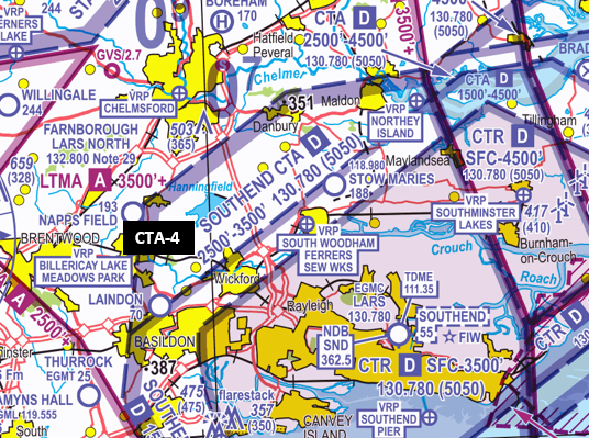
Figure 1 Chart extract from Sheet 2171CD Southern England and Wales Edition 49 (2023)
Pilot
The pilot reported that they were taking a family member for a flight in an area where they had flown many times before. They checked the local weather forecasts before flight and were aware of low cloud in the area of the intended flight (Figure 2).
The pilot stated that they would usually head in an easterly direction from North Weald aerodrome towards the Clacton VOR climbing below the LTMA (with a base of 2,500 feet AMSL) and then further to 3,200 feet when beyond Ongar and when the LTMA allowed but before Chelmsford. As they approached Chelmsford, they encountered scattered cloud (3-4 oktas) at 1,900 feet. To avoid that cloud the pilot turned right towards Southend’s controlled airspace. As they were now in the general area of Chelmsford, they continued their plan and climbed to 2,900 feet while now in the Southend CTA. They then recall being contacted by North Weald Radio and subsequently by Southend Radar.
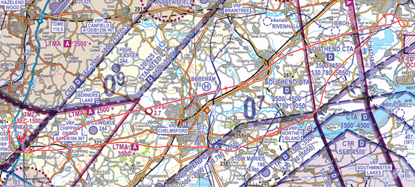
Figure 2 Chart extract from Sheet 8 England South Edition 27 (2023)
In a detailed post-analysis review of the occurrence, the pilot assessed the following as factors that led to the occurrence:
- Distraction. The pilot was overly focussed on the passenger’s interest in things both inside and outside the cockpit.
- Complacency. The pilot considered that their familiarity with the ground features in the area would be sufficient to make a short 40 minute without route planning. Although they were using a VFR Moving Map app on a portable device, they did not plot a route to their intended aerial destination of the Clacton VOR.
- Overconfidence. The pilot stated that having flown in the area for quite a number of years, they thought they knew the area well. However, navigation based on ground features was hampered by the amount of cloud.
- Flight Management. The pilot remained on the North Weald frequency for too long and when they called to advise changing frequency to Southend, their transmission was stepped on. Due to the delay and workload, the pilot was unable to make a further call before entering the CTA.
Findings and Causal/Human Factors
The pilot had intended to route to the north of the Southend CTAs enroute to the area of the Clacton VOR. However, cloud conditions along the route led to the pilot deviating south and towards the CTA with a base of 2,500 feet. Fixated on their plan to climb to their intended transit altitude and without a wider airspace plan, the pilot did not consider the lower CTA base when they turned right leading to them entering the CTA without a clearance.
The Pilot is to be commended for conducting detailed and honest post-flight analysis with recognition that complacency and overconfidence led them into a trap of thinking that a route did not need to be planned and plotted on a chart and transposed onto their VFR Moving Map application. Several contributory factors influence how the infringement developed, combined into two main areas, insufficient route planning and cockpit distraction.
Insufficient Route Planning
In the planning stage the pilot became aware that there may be low cloud in the area of the flight. The MetForm 215 forecast widespread scattered and broken cumulus and stratocumulus in the area between 1,500 feet and 3,500 feet. The pilot did not hold a valid IR/IRR and would therefore possibly be unable to maintain the required VFR criteria for flight above 3,000 feet (1,000 feet vertically clear of cloud) due to the cloud forecast tops (3,500 feet) and the base of the London Terminal Control Area in the area. Had that consideration taken place, the pilot may have considered flying VFR at a lower altitude with a contingency plan put in place in case a track deviation was required. In addition, the pilot’s communication plan lacked detail leading to them still being in communication with an ACGS unit close to controlled airspace and some 15NM away from North Weald. The Southend DOC is 40NM (UK AIP EGMC AD 2.18) and the Southend Frequency Monitoring Code is requested to be used (if an Air Traffic Service is not required) east of a line from Brentwood to Chelmsford. Had the pilot formulated a detailed plan, they would have been, as a minimum, monitoring the Southend frequency, thereby enabling the controller to resolve the infringement in a timely manner.
Cockpit Distraction
The aim for most private pilots, as was the case in this flight, is to share their aviation experiences with family members and friends. However, passengers can be a major cause of distraction and interruption, particularly if they are unfamiliar with flying in light aircraft. Diverting attention to check passenger wellbeing or answer questions has been cited as a contributory factor in several airspace infringement events and in this case interrupted the pilot from noting that a turn to the south also required the climb above 2,500 feet to be arrested. Some GA pilots may consider the sterile cockpit concept to be reserved for commercial air transport operations, but it is important to recognise that conversation is a powerful distractor.
Summary
The pilot deviated from their intended route due to encountering forecast and predictable cloud towards controlled airspace; when they deviated to the south, they did not amend the vertical aspect of the plan as was required with the lower base of the CTA in that area. Due to a perceived familiarity with the intended operating area, the pilot neither conducted a detailed route plan nor did they display it on a paper chart or their VFR Moving Map device. Two additional barriers in preventing the occurrence, being in communication with the most appropriate Air Traffic Service Unit and noting an alert from their VFR Moving Map device, became ineffective when the pilot become distracted from the primary tasks of AVIATE, NAVIAGE and COMMUNICATE by engaging with their passenger. As with most airspace infringements, the root causes lay with lapses in detailed planning and in applying effective Threat and Error Management associated with complacency and distraction. It is essential when interacting with passengers that a conscious effort is made to continue your external lookout, instrument scan and monitoring of your VFR Moving Map device.
As was the case in this occurrence, airspace infringement not only led to increased workload for one or more Air Traffic Service/AGCS units and disruption to IFR operations in controlled airspace but also in the service provision to other GA aircraft requesting a service or entry into controlled airspace.
Focus on
- Threat & Error Management and Pre-flight Planning and Preparation – read: Pre-flight planning
- Lower Airspace Radar Service and Frequency Monitoring Codes – read:
- Use of Moving Maps – read:
- Distraction and Interruption – read: CAA Safety Sense Leaflet 31 DISTRACTION AND INTERRUPTION IN GENERAL AVIATION OPERATIONS
This narrative has been written with the support of West London Aero Club which has kindly approved the sharing of images from its website.
Infringement of the Class D London Control Zone (CTR)
| Aircraft Category | Fixed-wing SEP |
| Type of Flight | Cross Country Recreational |
| Airspace/Class | London CTR/ Class D |
Met Information
METAR COR EGLL XX1250Z AUTO 09013KT 9999 -RA NCD 14/10 Q0993 TEMPO RA=
METAR COR EGLL XX1220Z AUTO 08013KT 9999 NCD 13/10 Q0994 TEMPO RA=
TAF EGLL XX1100Z XX12/XX18 09014KT 9999 SCT030 BECMG XX12/XX15 09017G27KT TEMPO XX13/XX24 7000 RA -RADZ BKN010 PROB40 TEMPO XX15/ XX22 3000 +RA BKN006 BECMG XX18/XX21 21020G30KT BECMG XX00/XX03 22010KT TEMPO XX00/XX11 6000 RA -RADZ BKN006 PROB30 TEMPO XX01/XX04 3000 RADZ BKN004 PROB30 TEMPO XX04/XX06 19015G25KT BECMG XX07/XX10 16012KT PROB40 TEMPO XX11/XX18 4000 +TSRAGS BKN014CB=
The Aerodrome and Airspace
White Waltham aerodrome sits partly within the London CTR and has an ATZ of 2NM radius extending from the surface to an upper limit of 2,000 above, or 2,127 feet AMSL. As a portion of this ATZ sits within the London CTR, a Letter of Agreement (LoA) is established between the air navigation service provider and the aerodrome to allow aircraft to operate within the portion of the ATZ that lies within the CTR as long as specified conditions are complied with. These conditions are listed in UK AIP AD 2 EGLM WHITE WALTHAM AD 2.22 FLIGHT PROCEDURES (see Figure 1 below). Flights must not leave the ATZ when within the London CTR unless in receipt of an individual clearance from Heathrow Radar.
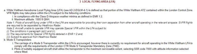
Figure 1: White Waltham Local Flying Area (LFA) procedures as detailed in the UK AIP. (Information correct as of AIRAC 07/2024).
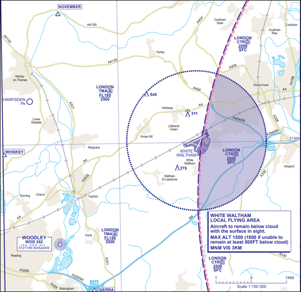
Figure 2: The aircraft left the White Waltham ATZ when still inside the Class D London CTR, indicating 900 feet, tracking southbound. Subsequently, the aircraft turned right and tracked south southwest and left the CTR.
Air Traffic Control
The Air Traffic Controller observed an aircraft on radar to the south southeast of White Waltham, tracking southwest, squawking 7000, indicating 900 feet. Two Commercial Air Transport (CAT) aircraft had previously been cleared for an ILS approach to Runway 09L at Heathrow Airport and were in the vicinity of White Waltham when the infringement occurred. Heathrow Approach is required to maintain separation of 3NM laterally or 3,000 feet vertically against unknown aircraft within their designated controlled airspace. An immediate loss of separation occurred between both CAT aircraft and the infringing aircraft. Separation between the first CAT aircraft and the infringing aircraft reduced to 1.4NM laterally and 1,900 feet vertically. Separation between the second CAT aircraft and the infringing aircraft reduced to 1NM laterally and 2,700 feet vertically.
Avoiding action was not issued as the controller observed the infringing aircraft to be tracking away from the Final Approach Track at Heathrow and was about to leave the CTR imminently. Furthermore, the controller deemed that turning the aircraft to the north would increase workload due to traffic density to the north of Heathrow combined with the challenging wind conditions on the day. A controller must react to an aircraft’s observed deviating from a recognised procedure (in this case the White Waltham departure procedure) and control known traffic defensively against the infringing aircraft’s unknown intention. This is challenging in a high traffic density operation.
Pilot
The pilot was on a VFR cross-country recreational flight from White Waltham to Biggin Hill, was carrying a CAA/NATS 1:250,000 chart and was using a VFR Moving Map device; however, several surface features such as motorways, roads, and towns were not displayed due to the pilot’s selected settings.
The pilot had planned to depart White Waltham and track through the London CTR via Ascot towards Biggin Hill. During taxi, White Waltham Radio informed the pilot that ATC were unable to accept the planned crossing; therefore, the pilot elected to form a contingency plan by routing west of the London CTR, through Farnborough controlled airspace en-route to Biggin Hill instead.
During the take-off run, the charts, which the pilot had placed on the passenger seat were dislodged and fell into the footwell of the aircraft. The pilot took the correct course of action and did not attempt to retrieve the charts during such a critical phase of flight and instead used the PLOG to ascertain the next heading to be flown. Unfortunately, the pilot did not fly the full downwind leg to exit the White Waltham ATZ before turning to the next planned heading. They were also focused on avoiding noise sensitive areas during turbulent conditions and in strong winds without the aid of a chart. This resulted in the aircraft leaving the White Waltham ATZ while still inside the London CTR.
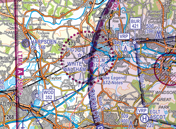
Figure 3: Approximate track of the aircraft after departure from White Waltham represented on the CAA-NATS 1:250,000 Southern England chart (Edition 28).
Findings and Causal/Human Factors
The pilot left the White Waltham ATZ, and therefore the LFA, when still inside the London CTR when departing from the aerodrome. The pilot experienced a loss of situational awareness as to their position in relation to controlled airspace after relying on the heading they had annotated on their PLOG while simultaneously attempting to avoid noise sensitive areas. The heading flown, however, was likely planned from the overhead and not from the point where it was executed which was 2NM southeast of the overhead and therefore insufficient to keep the pilot inside the LFA until west of the London CTR.
The event was underpinned by lapses in Threat and Error Management (TEM) and pre-flight planning in relation to the departure phase of the flight as well lapses in the management of the flight.
The pilot carried out post-flight analysis and commented on causal factors. As is the case in most aviation occurrences there was not a single cause. Several contributory factors led to how the occurrence developed:
Pre-Flight Planning
Route planning
The pilot conducted this flight using a VFR Moving Map and a NATS CAA 1:250,000 chart. The pilot had anticipated a routing through the London CTR via Ascot to Biggin Hill however had planned a contingency route via the Farnborough CTR-1. This included headings to be flown to reach each waypoint along the planned route.
Regulated aeronautical information
It is important to use regulated aeronautical information products from the NATS Aeronautical Information Service during pre-flight planning and preparation such as the most appropriate VFR charts and the UK AIP to ensure the most relevant and accurate information is available; this should then be supplemented with local information provided by the aerodrome relating to its specific patterns and local procedures. As part of this planning, it is important to ensure that the procedures for departure at your origin aerodrome and arrival at your planned destination and alternates are thoroughly covered. This planning should include exactly how you will leave the aerodrome of departure including significant landmarks in the vicinity of the aerodrome, such as motorways and towns, that will help you to maintain situational awareness. In the case of this occurrence, a thorough pre-flight plan could have identified that remaining north of the M4 motorway until at Junction 10 would have provided sufficient separation from the edge of the ATZ to remain in compliance with the LFA requirements and to have sufficient separation from the rest of the London CTR once outside of the White Waltham LFA.
Local procedures
The White Waltham aerodrome website provides a vast amount of good information relating to local procedures to assist pilots when arriving to, departing from and flying circuits at the aerodrome. The Operations’ Manual requires that “All pilots, whether members of WLAC or visiting, must read, understand and comply with these.” In addition, the Manual states “Aircraft are to depart from the most convenient circuit leg, maintaining the circuit leg track until clear of the ATZ. Overhead departures from a take-off are prohibited. It is acceptable for aircraft to reposition from the overhead to a visual reference point if required.”
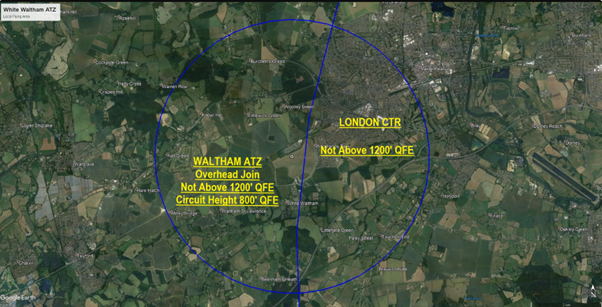
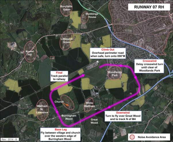
Contingency planning
The pilot had a contingency plan which they were executing; however, due to their charts not being accessible they attempted to fly the heading as written on their PLOG. Furthermore, this alternative route had been planned after engine start once it became apparent that a controlled airspace crossing of the London CTR would not be possible with an easterly operation at Heathrow Airport. The pilot could have ascertained the runway operation at the time and incorporated it in the planning stage and increased their situational awareness before starting the engine. Had this been the case the Plan B might have become Plan A and more time in a benign environment would have been available to study landmarks etc.
It is important for every flight to ensure a contingency plan has been made. This can include a plan in case of an aircraft emergency, weather avoidance due to unpredicted weather, passenger sickness etc. Ensuring you have a ‘Plan B’ will reduce the workload of the pilot, increase situational awareness, and reduce the risk of infringing notified airspace.
Meteorology planning
The pilot reported strong winds and turbulent conditions on the day which meant that the autopilot would not engage after departure. A thorough weather brief using regulated information from the Met Office website, for example Met Forms F214, F215, and GAMET should be completed prior to every flight and associated risks incorporated into the planned route. Ensure to utilise your VFR Moving Map to cross-check your position to maintain situational awareness, and to help you remain on track and prevent an inadvertent drift towards controlled airspace. The F215 for the day of the flight forecast widespread mean winds of 15-23 kts with gusts of up to 32 kts. The GAMET South East Region also forecast strong winds and turbulence would be present meaning it could be more difficult to engage the autopilot, or keep the autopilot engaged, at lower levels. A thorough meteorology plan should not just include the forecast conditions but what they could mean to you and your flight. For example, turbulence, although uncomfortable, may not pose much of a Threat to a flight unless its presence makes it more difficult to utilise the autopilot which in turn increases your workload.
Figure 4: GAMET South East Region Strong wind warning.
Figure 5: GAMET South East Region forecast
Threat and Error Management (TEM)
Pre-flight Preparation
The pilot commented that they used Runway 07 for departure and during the take-off run the charts had become dislodged after hitting a bump on the runway. This caused the charts to fall into the footwell of the aircraft and therefore were not accessible. The pilot stated that in future they would always secure the charts so that they cannot become dislodged.
It is important to consider the possibility of items becoming dislodged during critical phases of flight and therefore they should be stowed securely before take-off and landing. It is also important to consider the Threats associated with grass runways in that they may not be as smooth as harder surfaces meaning there is a greater chance of items becoming dislodged if not secured.
The planned route did not incorporate the CAA ‘Take 2’ guidance where pilots are encouraged to, where able, plan to remain at least 2NM from the edge or 200 feet below the base of subject airspace to avoid airspace infringements. It is recognised that departing from an aerodrome like White Waltham, within a CTR, it is not possible to comply with ‘Take 2’ immediately after departure. However, consideration should be given to the ‘Take 2’ concept once leaving the confines of a CTR/LFA with the risk of an airspace infringement identified during the planning of a departure.
Moving maps
The pilot was using a VFR Moving Map; however, they did not have all surface features selected meaning that line features and landmarks were not shown.
The correct use of a Moving Map can aid in preventing an airspace infringement. The CAA actively encourages pilots to use VFR Moving Maps in conjunction with the CAA NATS Chart as they can enhance a pilot’s positional situational awareness and can also offer timely alerts to airspace and aviation hazards. However, VFR Moving Maps are not regulated by the CAA, and it is important to understand their limitations including differing map depictions and altitude reference to GPS altitude rather than barometric altitude; in addition, some products allow their users to deselect features that may assist in VFR navigation. They should not be used as your sole means of planning and navigation and a backup should be carried to prevent a loss of situational awareness should your device malfunction. Consideration should be made as to when to use them in the circuit considering the priority of handling the aircraft and observing other traffic within the ATZ. Notwithstanding, they can still be used to assist in maintaining situational awareness when appropriate.
Summary
An infringement occurred when the aircraft left the confines of the White Waltham ATZ, and therefore LFA, when still inside the London CTR. Two instances of loss of separation occurred with the infringing aircraft and CAT before the infringing aircraft left controlled airspace.
The pilot had planned a route through the London CTR which was not able to be accommodated. This required the pilot to replan the flight at short notice resulting in the ineffective application of TEM at the planning and execution stages of the flight. The pilot lost situational awareness as to their position in relation to controlled airspace after their charts fell off the passenger seat during departure. This was compounded by the high workload the pilot experienced due to the forecast meteorological conditions that prevailed on the day.
Effective departure planning is essential when operating from aerodromes proximate to or within controlled airspace to ensure that you can operate the flight without infringing.
Focus on
- Pre-flight Planning
- Threat and Error Management
- Infringement Avoidance Online Tutorial
- ‘Take 2’ Initiative
- Avoiding Airspace Infringements
- Use of VFR Moving Maps
- Distraction and Interruption Safety Sense Leaflet (SSL)
- Meteorology Planning (Met Office)
Infringement of the Class G Hawarden Radio Mandatory Zone (RMZ)
| Aircraft Category | Fixed-wing SEP |
| Type of Flight | Cross Country Recreational |
| Airspace/Class | London CTR/ Class D |
Met Information
METAR EGNR XX0820Z 17003KT 130V210 9999 SCT022 14/09 Q1023=
METAR EGNR XX0850Z 15005KT 110V180 9999 SCT024 15/09 Q1023=
TAF EGNR XX0625Z XX06/XX15 12006KT 9999 SCT025 BECMG XX13/XX15 30010KT=
TAF EGGP XX0457Z XX06/XX06 09006KT 9999 SCT025 BECMG XX13/XX16 28010KT BECMG XX00/XX03 18004KT=
Aerodrome and airspace
Hawarden Airport is situated in Class G airspace to the southwest of Chester and proximate to the River Dee estuary. The elevation of Hawarden is 45 feet AMSL owing to its proximity to the River Dee estuary, however ground rises to the southwest of Hawarden reaching an elevation of 1,818 feet AMSL in some areas. Immediately north of Hawarden lies the Liverpool CTR and a Restricted Area established to protect Capenhurst. Furthermore, several Class A and Class D CTAs sit above Hawarden and in the immediate vicinity of the aerodrome.
Hawarden Airport primarily serves the onsite Airbus manufacturing plant and has several daily arrivals and departures of the specially adapted Airbus A330 BelugaXL aircraft. Training flights also take place at the airport as well as several charter and private flights. Furthermore, a National Police Air Service helicopter is based at the airport. To facilitate all these flights, Hawarden is serviced by an Air Traffic Control service and has Instrument Approach Procedures to both Runway 22 and Runway 04. In terms of airspace, arriving and departing aircraft are protected by a 2.5NM Aerodrome Traffic Zone (ATZ) and three Radio Mandatory Zones (RMZ) all established from the surface. RMZ-1 is situated to the northeast of the airport and has an upper limit of 2,500 feet AMSL where it meets the base of the Class D Manchester CTA-2. RMZ-2 surrounds most of the area surrounding ATZ to the east, south and west of the airport. The upper limit of RMZ-2 is 3,000 feet AMSL where it meets the base of the Class A Pepze CTA-1. Lastly, RMZ-3 sits to the southwest RMZ-2 and has an upper limit of 4,500 feet AMSL where it meets the base of the Class A Pepze CTA-3.
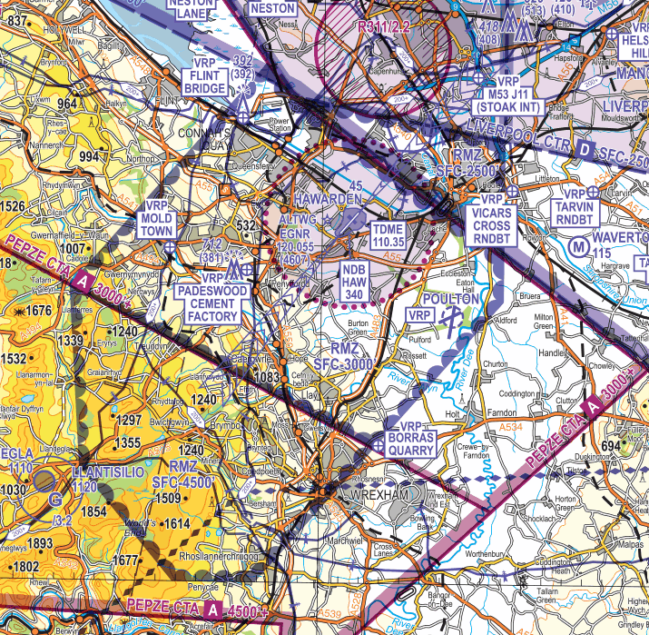
Figure 1: Hawarden ATZ and RMZ-1, RMZ-2, and RMZ-3 as shown on CAA/NATS 1:250,000 Sheet 5 Central England and Wales (Edition 15, 2023).
Air Traffic Control
The Air Traffic Controller observed an aircraft on radar, squawking 7000, 7NM northwest of Hawarden in an orbit. The aircraft was then observed to roll out of the orbit and enter the RMZ in the vicinity of Flint Bridge Visual Reference Point (VRP) tracking south towards Padeswood Cement Factory VRP. The aircraft then turned southwest bound, parallel to the Runway 04 approach track before leaving the RMZ to the southwest. Throughout the infringement, the controller made blind calls to the aircraft however two-way communication was not established until the aircraft had left the RMZ. A service was provided to the aircraft which then routed north. The controller elected to warn the pilot about controlled airspace proximate to them, the Holyhead Control Area (CTA), to avoid any further airspace infringements.
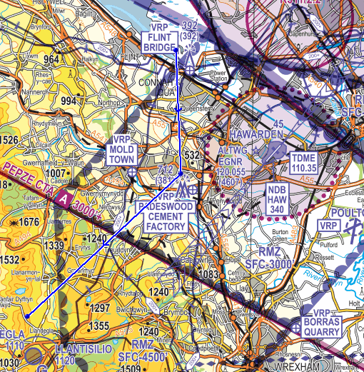
Figure 2: Approximate track of the aircraft through the RMZ represented on the CAA/NATS 1:250,000 Central England and Wales chart (Edition 15, 2023).
RMZ rulesets state that a pilot must establish and maintain two-way communications on the appropriate communications channel prior to entering and when inside the RMZ. Two-way communication is only considered established once the controller has received the following information from the pilot:
- Aircraft callsign
- Aircraft type
- Position
- Level
- Intentions of the flight
At Hawarden, compliance with the RMZ can also be achieved by following one of the alternative means as detailed in UK AIP AD 2 EGNR Hawarden 2.22 Flight Procedures. One of the methods detailed includes monitoring Hawarden Radar on 120.055 MHz and displaying the Frequency Monitoring Code (FMC) 4607 prior to entering and when inside the RMZ.
Pilot
The pilot was on a VFR cross-country recreational flight from Kirkbride to Belle Vue in North Devon, was carrying a CAA NATS 1:250,000 chart and was using a VFR Moving Map application on a tablet. They had planned to track from Kirkbride via Cark, Blackpool, over the west coast towards North Wales before crossing the Bristol Channel towards North Devon. They encountered reasonably good flying conditions with visibility in excess of 10KM and broken cloud with a base of 5,000 feet AMSL until they reached the Liverpool Bay area where the visibility reduced to between 3 and 4 KM, the cloud increased to overcast, and the base lowered to between 900 and 1,200 feet. The pilot had already descended to remain below the Liverpool CTA to the west of Liverpool and therefore had limited scope for a further descent to avoid cloud. They sighted more favourable weather to the south of their position and therefore elected to track towards it while attempting to call Hawarden Radar via radio; however, they were not successful in establishing two-way communication. At this point, the pilot focussed on flying the aircraft to find more suitable meteorological conditions and once they had achieved this, they established two-way communications with Hawarden Radar. Communications were still difficult due to the quality of the radio reception. As the weather had deteriorated below what the pilot had expected they elected to return to Kirkbride.
Findings and Causal/Human Factors
The pilot entered the RMZ when not in compliance with the published ruleset for flight within the airspace after encountering adverse weather along their planned route. It was established that the event was underpinned by lapses in effective pre-flight planning and Threat and Error Management (TEM) particularly in relation to the forecast weather along their route, as well as lapses in management of the flight.
The pilot carried out post-flight analysis and commented on causal factors. As is the case in most aviation occurrences there was not a single cause. Several contributory factors led to how the infringement developed as follows:
Pre-Flight Planning
Route and meteorology planning
The pilot conducted this flight using a VFR Moving Map and a NATS CAA 1:250,000 chart and had appropriately planned for the airspace along their planned This planning included descending to remain below the Liverpool CTAs to the west of the Liverpool in the vicinity of the coast and over the Irish Sea. The pilot had planned to avoid the Hawarden RMZ entirely and track southbound over Wales to the west. They anticipated the weather conditions to be favourable along the route and did not expect to encounter any low cloud or reduced visibility.
It is important to use regulated aeronautical information products from the NATS Aeronautical Information Service during pre-flight planning and preparation such as the most appropriate VFR charts and the UK AIP to ensure the most relevant and accurate information is available. As part of this planning, it is important to ensure that all regulated sources of meteorological forecast materials are consulted and understood prior to the flight so that informed decisions on routing can be made. In the case of this occurrence, the pilot had expected the weather conditions to be favourable and therefore had planned to track over the coast and sea to the west of Liverpool. On the day, the Liverpool and Hawarden TAFs did not indicate low cloud or reduced visibility; however, the UK Met Office has determined that a TAF for an aerodrome is valid for a 5NM radius of that aerodrome and may not include meteorological conditions further out. This can lead pilots into a false sense of security at the planning stages. Furthermore, a TAF and a METAR are limited in scope as to the tops of clouds and will only include a cloud type if it is a cumulonimbus (CB) or towering cumulus (TCU) cloud. However, all cloud types can be hazardous to aviation, and it is essential to reference the Met Forms F215 and GAMET at the planning stages to understand the forecast cloud types tops and how this will affect your flight.
TAF EGGP XX0457Z XX06/XX06 09006KT 9999 SCT025 BECMG XX13/XX16 28010KT BECMG XX00/XX03 18004KT=
TAF EGNR XX0625Z XX06/XX15 12006KT 9999 SCT025 BECMG XX13/XX15 30010KT=
The Met Forms F215 valid at the time of the occurrence had been published on the UK Met Office Aviation Briefing Service at 0300 UTC on the day of the flight. This form showed that the pilot could expect generally good flying conditions however cloud was likely to reduce in height over the sea and coast. Had this form been consulted and understood prior to the flight the pilot could have identified that the route planned was likely to result in less than favourable flight conditions and may have elected to plan a different track further inland or not perform the flight altogether.
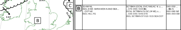
Figure 3: Excerpt from the Met Forms F215 Forecast Weather below 10000 FT valid at the time of the occurrence and published at 0300 UTC on the day of the flight. © Crown Copyright 2024
Contingency planning
As the weather forecast included the chance of low cloud it would have been good practice to have a contingency plan. This plan could have included routing further inland and making use of the Manchester Low Level Route (LLR), obtaining a controlled airspace crossing clearance, or diverting to an aerodrome to the north of the Liverpool Bay area such as Blackpool. Furthermore, the likelihood of having to track around the high ground in North Wales meant that there was a possibility of entering the Hawarden RMZ. A good contingency plan would include the conditions required to comply with the RMZ ruleset, such as displaying the Hawarden FMC and monitoring Hawarden Radar.
It is important for every flight to ensure a contingency plan has been made. This can include a plan in case of an aircraft emergency, weather avoidance due to unpredicted weather, passenger sickness etc. Ensuring you have a ‘Plan B’ will reduce the workload of the pilot, increase situational awareness, and reduce the risk of infringing notified airspace. It is advisable to consider the “least restrictive” route as your Plan A. For example, if you wish to cross controlled airspace consider that as your Plan B as it relies on a clearance being issued which may not always be possible. For that reason, tracking outside controlled airspace has already been planned for and is not the “back-up” plan.
Threat and Error Management (TEM)
Confirmation bias
The pilot commented that they had expected the weather to be better and that they decided to continue with their flight which resulted in them infringing notified airspace. Confirmation bias is a regular contributing factor to airspace infringements and in the case of this occurrence the pilot had pressed on into weather which they had not expected to encounter as they believed the conditions would not be as bad as they were observing. The pilot commented that a better course of action would have been to turn around before Liverpool and find an alternative route.
Use of an Air Traffic Service (ATS) or FMC
The pilot was not in receipt of an ATS prior to the infringement and was not required to be; however, an ATS can help to reduce workload in situations such as this. All UK Flight Information Services (FIS) include the passing of meteorological information to pilots when required and in the case of this occurrence the pilot could have obtained a service from Liverpool Radar prior to commencing the water crossing to the northwest of Liverpool. This would have allowed the pilot to request any reported adverse weather conditions from other pilots also in receipt of a service from Liverpool Radar.
Considering the contingency planning discussed in the pre-flight planning section above, the pilot could have also used the Hawarden Frequency Monitoring Code (FMC) when it became apparent that they were required to enter the RMZ. By selecting the FMC and monitoring Hawarden Radar the pilot would have complied with the published ruleset and would have avoided an airspace infringement.
Figure 4: Hawarden RMZ procedures published in the UK AIP. Information correct as of AIRAC 08/2024. This screenshot should not be used for flight planning. You must refer to the most recent AIP entry and any relevant NOTAM prior to flight.
Summary
In conclusion, an infringement occurred when the aircraft entered the RMZ whilst not in compliance with the ruleset published in the UK AIP. The pilot had planned a route which did not enter the Hawarden RMZ; however, they had not appropriately considered all the meteorological information published by the UK Met Office. Had they done so, they would have identified that low cloud was possible over the coast and when they observed this cloud when north of Liverpool it is likely that they would not have flown into the area. A contingency plan had not been considered as the pilot did not expect to experience low cloud along their route therefore the pilot continued over the sea and coast, subsequently tracking southeast, and entering the RMZ. The pilot had attempted to establish two-way communication with Hawarden Radar when to the northwest of the RMZ however had been unsuccessful likely due to their low level and the high terrain in the area. As the situation deteriorated the pilot focussed on flying the aircraft away from the adverse weather before establishing two-way communication with Hawarden Radar.
This occurrence emphasises the importance of accessing and understanding all the published regulated meteorological information from the UK Met Office prior to every flight. By knowing the weather to expect, pilots can formulate an appropriate plan, including contingency routes, and all relevant Air Traffic Service Units along the route. Appropriate planning can also help to break confirmation bias; however, it is important to fly the weather encountered rather than the weather expected. Air Traffic Controllers are there to assist pilots and can provide updated weather information if they have it. TAFs and METARs are useful to plan for weather in the vicinity of aerodromes; however, they have their limitations when it comes to the types and tops of clouds. Furthermore, a TAF may not cover the area along the planned route.
Focus on
- Pre-flight Planning
- Threat and Error Management
- Infringement Avoidance Online Tutorial
- ‘Take 2’ Initiative
- Avoiding Airspace Infringements
- Use of VFR Moving Maps (CAA Safety Sense)
- Meteorology Planning (UK Met Office)
Infringement of the Class D Farnborough Control Area 1 (CTA-1)
| Aircraft Category | Fixed-wing SEP |
| Type of Flight | Cross Country Recreational |
| Airspace/Class | Farnborough CTA / Class D |
Met Information
METAR EGLF Z XX1020Z 04013G24KT 360V060 9999 SCT022 06/M01 Q1025
METAR EGLF XX1050Z 06014KT 9999 SCT026 06/M01 Q1025
Air Traffic Control
The Air Traffic Controller reported operating as Farnborough West and Farnborough Zone band-boxed in busy traffic. The aircraft had been handed over from Farnborough LARS North requesting a Farnborough controlled airspace transit. The aircraft was asked to squawk Mode A 0460 (for Zone) and placed under a Basic Service. A transit clearance was issued routing Southwest of the Bagshot Mast to the Ockham VOR/DME (OCK), not above altitude 2,000 feet, VFR, remaining outside the London Control Zone (CTR). This was read back correctly after being challenged for an omission from the clearance in the initial read back.
Whilst monitoring the track of the aircraft, the service was changed from a Basic Service to a Radar Control Service as the aircraft entered LF CTR-1 southwest of the Bagshot Mast and then back to a Basic Service as the aircraft vacated the Farnborough CTR-2 in the vicinity of Woking. The aircraft requested to route via OCK after leaving Farnborough CTR-2 and was advised that they could resume their own navigation.
Whilst the aircraft was maintaining 1,900 feet beneath CTA-1 (base of 2,000 feet AMSL), the controller instructed the pilot to reset squawk 0435 (for LARS). The controller was imminently to issue advice that the aircraft was operating at the base of controlled airspace, as the aircraft’s altitude was observed to climb to 2,100 feet, which triggered an Airspace Infringement Warning (AIW) alert. The controller informed the pilot that they had entered controlled airspace and instructed them to descend to be not above 2,000 feet to remain outside. The pilot apologised and the aircraft was then observed to descend to leave controlled airspace.
Note: The Ockham VOR is no longer certified for en-route navigation. While its DME has a designated operational coverage (DOC) of 70NM, the VOR component is retained solely for terminal and approach procedures at select airports, including Heathrow.
Figure 1: The aircraft entered the Class D CTA-1 indicating 2,100 feet where the base of controlled airspace is 2,000 feet AMSL.
Pilot
The pilot reported that they had planned to fly a route anticlockwise round the London CTR. The route had been planned on a VFR Moving Map as follows:
Bovingdon VOR/DME (BNN) – Woodley NDB (WOD) – Farnborough Airport (EGLF) Zone Transit – OCK
Figure 2: Route flown represented on the CAA/NATS 1:500,000 South – Ed.51
The pilot reported that a zone transit was sought through Farnborough’s CTR and granted not above 2,000 feet to the west of Bagshot mast. Once outside controlled airspace, approval was given to take up their own navigation direct OCK under a Basic Service. During this phase the pilot was advised they had climbed into controlled airspace, at which time they apologised and immediately descended. The pilot reports that from their VFR Moving Map log, it would suggest they had entered controlled airspace for approximately 2 minutes. The pilot stated that they encountered significant thermal activity when proceeding direct OCK necessitating power changes and inputs to maintain a constant altitude from time to time during the flight.
In discussion with the pilot post event
The pilot explained that this cross-country flight was conducted to maintain their currency and prevent skill fade. The pilot further explained that flying this route, around controlled airspace, was intended to not only help to maintain their flying skills but also allowed them to check that the aircraft’s avionics worked as expected.
In the lead up to the infringement, the pilot stated they were tracking direct OCK. It was at this time they experienced significant tail-lift pushing them up to 2,100 feet and thus infringing the Farnborough CTA-1. The pilot confirmed they were not using the aircraft’s autopilot. They further explained that it was whilst transiting initially beneath the CTA-1, they were tuning in to the Ockham VOR/DME.
The pilot expressed they wanted to remain as high as possible at all times whilst operating outside of controlled airspace in order to provide time to troubleshoot and perform a forced landing if necessary. Their rationale was based on having previously experienced 3 partial power losses. As a result, they had become normalised to fly at a higher altitude wherever possible. The pilot explained that they found cockpit workload inevitably increased when flying around the London CTR due to the extent of controlled airspace and ‘choke points’ around the area.
Findings/Causal Factors
The infringement occurred due to an inadvertent climb into the CTA when planning to fly 100 feet below the vase of controlled airspace due to thermic activity and possibly compounded by distraction when setting their VOR equipment. Whilst the pilot reacted quickly to the climb, the response was insufficient to prevent the aircraft entering controlled airspace as the aircraft was operated just below the base. However, a number of valuable lessons emerged from this occurrence which may be relevant to us all as pilots.
It was established that the event was underpinned by lapses in pre-flight planning, Threat and Error Management (TEM) and management of the flight.
The pilot is to be commended for their openness and post-occurrence actions. The pilot carried out post-flight analysis and commented on causal factors. As is the case in most occurrences there was not a single cause, several contributory factors led to how the infringement developed.
Pre-Flight Planning
Route planning
The pilot elected to fly 100 feet below the base of controlled airspace in thermic/turbulent conditions. Pilots are advised to maintain adequate separation from notified airspace through the application of the ‘Take 2’ guidance (where able, plan to remain at least 2NM from the edge or 200 feet below the base of the subject airspace) to avoid airspace infringements. The ‘Take 2’ initiative is neither a buffer based on State policy, nor is its application mandatory; it is merely guidance based on the principle of good airmanship, introduced by pilots to help their fellow pilots and other airspace users. If following this guidance places the pilot in an uncomfortable position, this is a threat, and should be addressed during the pre-flight planning stage, with potentially a less restrictive route decided upon.
Meteorology Planning
The pilot reported they encountered significant thermal activity when proceeding direct OCK necessitating power changes and inputs to maintain a constant altitude from time to time during the flight.
A thorough weather brief using regulated information from the Met Office Aviation Briefing Service website, for example Met Forms F214 and F215, should be completed prior to every flight and associated risks incorporated into the planned route. Local conditions can vary from what is forecast, reinforcing the advice to maintain adequate separation from notified airspace through the application of the ‘Take 2’ guidance. The recommended 200 feet distance may need to be increased during flights where turbulence or thermic conditions are encountered to prevent inadvertent climbs into controlled airspace.
Threat and Error Management (TEM)
Distraction
The pilot explained that whilst transiting beneath CTA-1, they were tuning in to the Ockham VOR/DME. Although it cannot be ascertained to what extent tuning into the VOR contributed to the infringement, operating proximate to controlled airspace and having just completed a zone transit and now prompted to reset the squawk, the pilot could have become task saturated. By not following the ‘Take 2’ guidance would further have reduced the pilot’s ability to remain below controlled airspace. In this instance, applying the ‘Aviate, Navigate, Communicate’ principle would have allowed the pilot to maintain their altitude relative to the base of controlled airspace. Thorough pre-flight planning would enable this threat to be identified, and the pilot could have planned to tune into the Ockham VOR/DME at a time where cockpit workload was low (prior to the Farnborough CTR transit).
VFR Moving Map
The pilot was using a VFR Moving Map application; however, it could not be ascertained what alerts were present, if any, and the response to them. When configured correctly VFR Moving Maps can not only enhance a pilot’s situational awareness in flight, but they can help to reduce confirmation bias and can also offer timely alerts to airspace and aviation hazards. Operating around controlled airspace will alert the pilot to controlled airspace proximate to their position (if configured correctly); however, there is a human factors element present whereby the pilot intuitively accepts/cancels the alert without having fully assimilated the information given. This can be especially true in cases where pilots are familiar with the airspace or are subjected to constant multiple alerts leading to ‘alert fatigue’. Every flight, even along routes previously flown, should be thoroughly planned, addressing the potential threats and errors for each phase of flight.
The CAA actively encourages pilots to use VFR Moving Maps in conjunction with the CAA/NATS Chart. However, VFR Moving Maps are not regulated by the CAA, and it is important to understand their limitations including differing depictions and altitude inaccuracies. They should not be used as your sole means of planning and navigation and a backup should be carried to prevent a loss of situational awareness should your device malfunction.
Summary
In conclusion, Human factors play a major role in many airspace infringements and in this case, the desire to remain as high as possible when flying outside of controlled airspace and distraction, resulted in the pilot inadvertently climbing into controlled airspace after the significant thermic conditions encountered. The pilot carried out effective post flight analysis and was open and honest about the occurrence in line with Just Culture.
Focus on
- Threat & Error Management
- Pre-flight Planning and Preparation
- Distraction and Interruption (CAA Safety Sense)
- Meteorology Planning (UK Met Office)
- VFR Moving Maps (CAA Safety Sense)
- ‘Take 2’ Initiative
Controller’s stories
A series of controller’s stories from NATS
Mark Davenport, an air traffic controller at Swanwick centre, talks about his experience with airspace infringements. Airspace Infringement Series: A controller’s story… (20 May 2019)
Brian Ringrose is an air traffic controller at Swanwick centre. He talks about his experience looking after airspace around Gatwick. Airspace infringement series: A controller’s story (12 April 2019)
Amanda Rhodes is an air traffic controller at Swanwick Centre. She talks about her experience looking after airspace around Luton Airport. Airspace Infringement Series: A controller’s story (22 March 2019)