| Airport/Aerodrome/Airspace | Area/Subject | Narrative Number |
| Aberdeen | Aberdeen | 31 |
| Aerodrome Traffic Zones | Rule 11 | 14 |
| Manchester Barton | 7 | |
| RAF Topcliffe | 36 | |
| Birmingham | CTA-2 | 3, 34 |
| Brize Norton | CTR | 11 |
| Channel Islands | Channel Islands Airspace | 27 |
| Coventry Aerodrome | ATZ | 34 |
| East Midlands | CTA-2 | 8 |
| Edinburgh | All CTR and CTA | 29 |
| Farnborough | All CTR and CTA | 10 |
| Blackbushe operations | 19 | |
| Farnborough CTA-1 | 39 | |
| Fairoaks | 40 | |
| Flight Information Services | London & Scottish Flight Information | 23 |
| Gatwick | CTA and Redhill aerodrome | 15 |
| Halton | ATZ | 28 |
| Hawarden | RMZ | 6 |
| Liverpool | All CTR & CTA | 13 |
| London Control Area | LTMA | 22 |
| Luton | CTR & western CTA | 24 |
| Manchester | East of CTR | 12 |
| Newcastle | CTA & CTR | 33 |
| NOTAM | Deactivation of Controlled Airspace | 17 |
| Pendine Danger Area | Danger Area | 32 |
| Prohibited and Restricted Airspace | EG P, EG R & RA(T) | 20 |
| Solent | South of CTR (CTA-2) | 4 |
| North of CTR (CTA-3 & CTA-5) | 9 | |
| Hot-spots in the Solent and Southampton area | 26 | |
| Southend | CTA & CTR | 18 |
| Stansted | CTA, CTR & TMZ | 16, 35, 38 |
| White Waltham | London CTR | 41 |
Preventing airspace infringements in the vicinity of Warwick
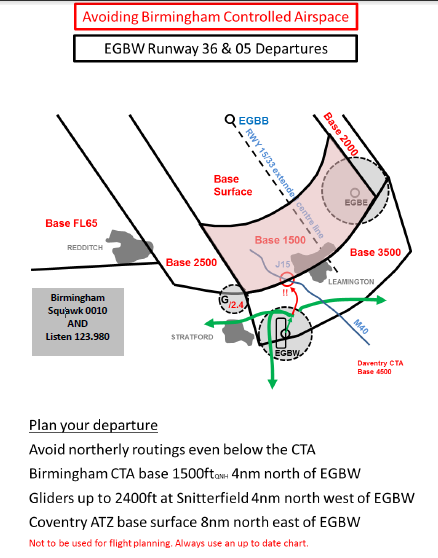
This infringement update is the third in a series of narratives focusing on identified infringement ‘hot-spots’ in the UK. It has been written by members of the Midlands LAIT: Birmingham Airport Air Traffic Limited, the Flight Information Service Officers at Coventry Airport and Wellesbourne Mountford Aerodrome and the CAA.
A constant ‘hot-spot’ for airspace infringements is the Birmingham Control Area 2 (CTA2) which lies to the south of the Birmingham Control Zone. Its base of 1,500 ft amsl (based on the Birmingham QNH) and extends to 4500 ft amsl to the base of the Daventry CTA (Class A). The Birmingham CTR and CTA are both Class D controlled airspace. In the period from 1 January to 11 October 2019, there were 21 infringements of CTA 2 amounting to 56% of all airspace infringements affecting Birmingham controlled airspace. The airspace is in place to facilitate descents to final approach to Runway 33 and departures from Runway 15. Significant ground features in the vicinity of the CTA are Leamington Spa and Warwick which straddle the boundary between CTA 2 and CTA 4 (base level 3,500 ft Birmingham QNH), the M40 motorway and Coventry Airport and city to the northeast. Warwick Castle, a popular scenic turning point, lies almost 1nm north on the southern boundary of, and under CTA 2.
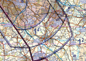
CTA2 and CTA4
Following consultation with the Birmingham Local Airspace Infringement Team, the CAA, and a review of infringement data, Birmingham Airport has taken the decision to remove the M40 J15 Warwick VRP (with effect from 10 September 2020). The 1:500,000 and 1:250,000 VFR charts will be amended when re-issued. Pilots are reminded that routing to the south of Royal Leamington Spa will prevent an infringement of CTA-2.
An infringing aircraft that is not radar identified by Birmingham Air Traffic Control becomes unknown traffic; a separation standard of 5nm laterally or 5,000 feet vertically is required between that aircraft and IFR aircraft inbound to, or outbound from, Birmingham Airport.
Arrivals to Runway 33 are routed through CTA 4 (3,500 feet to 4,500 feet) descending into CTA 2 (1,500 feet to 4,500 feet) prior to entering the CTR (surface to 4,500 feet) prior to landing (see chart 2). As the inbound traffic will be descending, the air traffic controllers have little option other than to either break the aircraft off the approach or issue radar vectors to maintain 5nm lateral separation or to stop an aircraft’s descent 5,000 feet above the unknown traffic posing the challenge then to descend the aircraft in sufficient time to establish a stable approach.
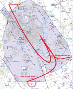
Runway 33 Arrivals
Arrivals to Runway 15 from the south are routed via either downwind left-hand or right-hand through CTA 4 and CTA 2 into the CTR as depicted in Chart 3. As the inbound traffic will be descending, the air traffic controllers have little option other than to issue radar vectors to maintain 5nm lateral separation or, if they are still high enough, to stop an aircraft’s descent 5,000 feet above the unknown traffic.
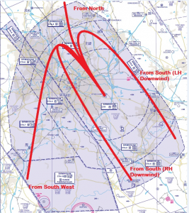
Runway 15 Arrivals
Departures from Runway 15 at Birmingham Airport will climb out towards CTA 2 and CTA 4 (see chart 4). Again, to maintain standard separation of 5nm laterally or 5,000 feet vertically, departing aircraft may have to be issued with radar vectors; in addition, depending on the position, heading a height of the infringing aircraft, departures may need to be suspended and inbounds issued with amended missed approach.
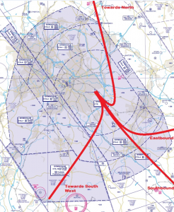
Runway 15 Departures
Non-squawking aircraft operating underneath the CTAs will be deemed to be clear of controlled airspace; should that traffic be infringing controlled airspace, the risk of a mid-air collision is heightened.
Inbound to or Outbound from Coventry Airport?
Coventry lies underneath Birmingham Control Area 2 (CTA2), and the base of this controlled airspace is 1500ft QNH (1267ft Coventry QFE). Due to the high risk of potential confusion, Coventry will issue the Coventry QNH rather than QFE to aircraft in/outbound (QFE is available on request but remember the base of controlled airspace is close).
No overhead joins are permitted due to the controlled airspace above. Straight in approaches are not encouraged due to integrating with circuit/joining traffic via the following VRP’s.
For Runway 23, routing is via Draycott water VRP to integrate with circuit traffic on left base. For runway 05, routing is via Southam VRP to integrate with circuit traffic on Right base. Circuit altitude is 1,200 feet QNH (Height 1000 feet QFE).
Once on the Coventry frequency, pilots will be given the Coventry conspicuity squawk and reminded to remain outside AND BELOW controlled airspace, as an aid to help prevent airspace infringements.
Aircraft routing around the Coventry ATZ/through the runway approaches for Coventry should contact Coventry Information on 123.830 MHz for a basic service and any relevant traffic information. Traffic on the Birmingham 0010 will not be passed traffic into/outbound from Coventry by Birmingham radar and will not be monitoring your flight around Coventry!
Inbound to or outbound from Wellesbourne Mountford?
When operating to/from Wellesbourne Mountford remember that the aerodrome elevation is almost 150 feet; this equates to 5 hPa. If you are flying on the Wellesbourne QFE, remember its relationship to the Birmingham QNH; you could be flying higher than you think in relation to controlled airspace. When departing to the northwest or northeast, make a plan that includes the wider airspace picture. Consider how to avoid Snitterfield Gliding Site (winch launching up to 2,400 feet amsl) early in your plan; a recent airspace infringement saw a pilot, who was flying from Wellesbourne Mountford to Halfpenny Green, make a late plan to avoid Snitterfield to the east after climbing to 2,000 ft. This resulted in the pilot infringing CTA2; an early plan to route via Stratford-Upon-Avon and Studley would have kept the aircraft well clear of the lower CTA. To assist in this, the team at Wellesbourne Mountford have produced a much-simplified diagram. Published primarily for departures from Wellesbourne it applies equally to inbound and transit traffic. It is published on the website and regularly briefed to visitors.
Avoiding Birmingham Controlled Airspace
To prevent an airspace infringement, as part of their pre-flight planning and in-flight execution, pilots are strongly encouraged to:
Use a Moving Map and where able Take 2;
Obtain an air traffic service.Know which ATS unit can provide a LARS. To the west and northwest, it is Shawbury (133.150MHz), to the south and southwest it is Brize Norton (124.274 MHz) and to the northeast it is East Midlands (134.180MHz).
Use the FMC. Rather than squawking 7000, if you do not want to obtain a service from ATC, use a Frequency Monitoring Code by squawking 0010 and monitoring 123.980MHz. Obtain the Birmingham QNH from the ATIS frequency (136.030 MHz) or by listening to that given to other aircraft on 123.980MHz
Avoid flying on the RPS in the vicinity of Birmingham CTAs. When flying on the RPS, as it is the forecast lowest QNH for a region, you will be higher in relation to the Birmingham QNH. If you are receiving a FIS from London Information, ask the FISO for the Birmingham QNH rather than remaining on the Barnsley RPS (or Cotswold RPS if flying from the southwest). In addition, this can be obtained on the ground prior to departure by calling Birmingham’s ATIS number of 0121 767 1260; this not only gives the QNH but will also give you an idea of the runway in use, the current weather and TAF.
Make a Detailed Plan. Build in your climb and descent points when routing in the vicinity of multiple CTAs with differing base altitudes. Know what VRPs look like and what airspace lies above them or close by.
Preventing airspace infringements in the vicinity of the Solent
This infringement update is the fourth in a series of narratives focusing on identified infringement ‘hot-spots’ in the UK. It has been written by members of the Solent LAIT, Southampton Airport and Southampton Air Traffic Control.
The Solent airspace comprises the Southampton Control Zone (CTR, surface to 2,000 feet amsl) and eight Solent Control Areas (CTA) as depicted in Chart 1. The CTA‐2 portion of the Solent CTA extends from 2,000 feet to 5,500 feet and also above the CTR to 5,500 feet amsl. Southampton in subject to over 100 airspace infringements during a year the majority of which are in CTA‐2.
This specific CTA‐2 comprises an area over the New Forest and western Solent (including a segment over the north west of the Isle of Wight) under which lies a wide area of Class G airspace between the control zones of Southampton and Bournemouth. When we look at the infringements that do occur most are caused by aircraft infringing the base of that airspace.
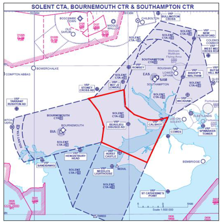
Chart 1: Solent CTA‐2 outlined in red
An infringing aircraft that is not radar identified by Solent Radar becomes unknown traffic; a separation standard of 3nm laterally or 3,000 feet vertically is required between that aircraft and IFR aircraft inbound to, or outbound from, Southampton Airport or operating within Southampton/Solent controlled airspace.
Commercial aircraft can be operating 500ft above the base of controlled airspace. Both Bournemouth and Southampton have instrument approaches that commence in CTA‐2, often with commercial aircraft descending to 500 feet above the base of controlled airspace (as is standard operating procedure, see Chart 2). Any infringement of the CTA‐2 here can cause a loss of separation which has serious implications for all concerned with ATC having to take mandatory avoiding action and a full investigation being carried to the incident. This will usually involve the controller being unable to continue working until a preliminary investigation is complete. It may also result in delay for commercial passengers and crew.
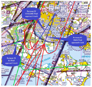
Chart 2: Typical inbound routes using CTA‐2 (Southampton routes for Runway 02 in Red – Bournemouth routes for Runway 26 in Green)
Important factors to think about when flying under the CTA‐2
Set the right QNH. The base of controlled airspace is determined by the local ‘Solent’ QNH, not the Portland RPS. A difference of 3‐4 hPa is not unusual and aircraft flying close to the base of controlled airspace can inadvertently infringe just by having the wrong (inappropriate) QNH selected.
Take 2. An initiative through the Local Airspace Infringement Teams (LAIT) is to Take 2. By remaining at least 200 feet below the base, or 2nm horizontally away from the edge of a block of controlled airspace then, any inadvertent deviation from level flight or planned course could be caught in sufficient time to prevent an airspace infringement. As mentioned in the introduction, it is especially important when flying ‘under’ the Solent CTA‐2 – i.e. below 2000ft. A radar controller can usually see traffic operating beneath controlled airspace while controlling inbound traffic to Southampton (and in principle in this area, Bournemouth too) and has to expect such aircraft to remain outside the CTA‐2. Any vertical deviation that results in an aircraft entering the CTA‐2 (without a clearance) can immediately cause a loss of separation with an aircraft within. This quickly becomes a significant safety event employing avoiding action, creating a highly elevated workload with yet greater risk and resulting in all the reporting action and investigation that that entails. If you just ‘pop up for a moment’ it can easily be as significant as a horizontal infringement from an ATC perspective. As can be seen in Chart 2, the entire area of CTA‐2 is used for approaches to Runway 02 at Southampton and Runway 26 at Bournemouth.
Use the appropriate FMC (Listening Squawk) and listen out. The airspace below the CTA‐2 is Class G airspace (uncontrolled). There is no requirement to receive a service from either Bournemouth ATC (to the west) or Southampton ATC (the controlling authority). However, the introduction of the Frequency Monitoring Code (7011 for Southampton/Solent Radar – 120.230MHz, or 0011 for Bournemouth Radar 119.475MHz) enables ATC at those units to observe an aircraft that may be of potential conflict to their traffic inside controlled airspace and interrogate such an aircraft when appropriate. The use of this FMC has been proven to prevent infringements and reduce the severity of such occurrences and enhance the controllers’ and pilots’ situational awareness creating a safer and more predictable situation than would otherwise prevail. The agreed ‘demarcation’ line between the Solent and Bournemouth FMC is a line orientated northwest to southwest between Stoney Cross and Hurst Castle; to the west it is Bournemouth (0011/119.475MHz) and to the east is Solent Radar (7011/120.230MHz).
If appropriate – request a clearance. If for any reason a climb is required above the base of 2,000 feet in CTA‐2, then a clearance must be obtained. Depending on a variety of factors, not least the runway in use and traffic situation at the time, this may well be available. By obtaining a clearance to enter controlled airspace when appropriate, ATC are able to control more effectively and ensure safety is maintained.
Visual Reference Points (VRPs)
To help orientate yourself, and also enable a position report if you are talking to an ATC unit, there are five VRPs (Chart 3 below) which lie under or close to CTA‐2:
Cowes VRP is the harbour at the mouth of the River Medina on the Isle of Wight lying to the east of CTA‐2 and under the Portsmouth CTA with a base of FL65. The VRP acts as a prominent geographical feature by which to be below 2,000 feet (Solent QNH) when routing westbound and to remain below 2,000 feet QNH when routing eastbound.
Calshot VRP lies on the edge of the Southampton CTR (SAM 177°/8 nm) and is the site of the Calshot Power Station with a single chimney to the west of Calshot Castle and the activities centre. Pilots intending to operate in Class G airspace using this VRP should remain south of the VRP and below 2000 feet on the Solent QNH.
Beaulieu VRP is the site of the old RAF Beaulieu aerodrome on Beaulieu Heath. It can be identified at having 3 former runways in the standard WWII triangular configuration with the apex to the north.
Hurst Castle lies to the south of CTA‐2 and under CTA‐8 with a base of 3,500 feet amsl (on the Solent QNH).
Stoney Cross VRP is the site of the old RAF Stoney Cross aerodrome to the north of the A31 road leading to the start of the M27. The VRP lies on the western edge of CTA‐4 (base 2,500 feet Southampton QNH).
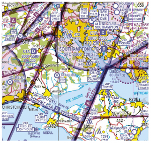
Chart 3: Solent VRPs on the half‐mil VFR chart
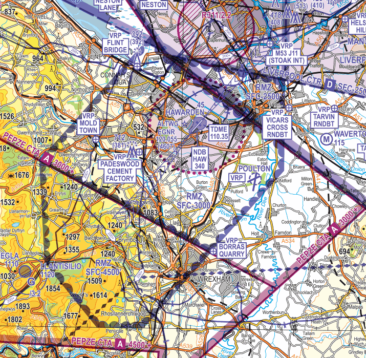
Hawarden Radio Mandatory Zone (RMZ)
This infringement narrative focusing on identified infringement hot-spots in the UK. It has been written by the air traffic control team at Hawarden aerodrome which is a key member of the Northwest LAIT.
The Hawarden RMZ is one of two RMZs in the UK and there are four ways in which pilots can enter the notified airspace. It is important to note that the other RMZ (Land’s End) has different ways to gain access (UK AIP EGHC AD 2.22 Paragraph 1 refers).
Background
Due to Hawarden’s location in uncontrolled airspace it was becoming ever more difficult to de-conflict aircraft on Standard Outbound Clearances (SOCs) from the myriad of non-communicating flights permitted to operate in uncontrolled airspace. To maintain the safety of all aircraft, Hawarden ATC is required to avoid conflictions to planned Hawarden departures by delaying an aircraft’s take-off until unknown traffic is no longer an operational issue.
Control of inbound airways traffic to Hawarden Airport is transferred to Hawarden ATC within the protection of Controlled Airspace. However, all Runway 04 final approach paths and several critical areas of the Runway 22 final approach are located in Class G airspace, where Hawarden traffic may come into conflict with unknown, non-communicating aircraft. In cases of such conflict, Hawarden ATC would provide an extended routing to their traffic, which resulted in an increased fuel burn and the associated environmental impact.
Numerous high velocity and heavy aircraft operating at Hawarden Airport made the ‘see and avoid’ principle incompatible with Class G operations. This was particularly important when Airbus A300-600ST ‘Baluga’ was replaced by the Airbus BelugaXL (A330-743L). If the pilots’ intentions could be ascertained, this would increase situational awareness, and allow controllers the ability to plan ahead accordingly.
The Radio Mandatory Zone (RMZ) was introduced in 2017 and would require all aircraft to make and maintain two-way radio contact with Hawarden ATC and advise ATC with pertinent flight details. This would generate a known traffic environment. An RMZ would not permit Hawarden ATC to deviate the route of all traffic to aid deconfliction; it would, however, generate the known traffic environment within which the lower de-confliction minima can be applied (in accordance with UK FIS) and Hawarden traffic could be routed with the confidence that routine unexpected manoeuvres of aircraft do not need to be taken into account.
It was recognised that the establishment may generate some operational restrictions to non-radio equipped aircraft which currently utilise the airspace. To this end, it was necessary to permit some ‘alternative means of compliance’ to be developed which would allow operators to access the airspace, yet still provide Hawarden ATC with a known traffic environment. It was considered that the option of an RMZ provided the most balanced solution with due regard to Hawarden Airport operators and other airspace users.
Hawarden RMZ
The RMZ comprises the following three areas:
- Area 1 lies to the north and is located underneath the Manchester Control Area (CTA2); the RMZ here extends from the surface to 2,500 feet AMSL.
- Area 2 is the largest area and lies overhead the Hawarden ATZ and to the south; it extends for the surface to 3,000 feet AMSL.
- Area 3 lies to the south and is located over the western part of Wrexham and over the high ground to the south of Hawarden aerodrome; it extends for the surface to 4,500 feel AMSL.
Above RMZ Areas 2 and 3 are the Class A Pepze CTA-1 and CTA-3 which extend upwards to FL195; the controlling authority for this airspace is Scottish Area Control Centre (callsign Scottish Control on 128.055 MHz)
All three areas are charted on VFR charts with blue semi-circles on the inside of the boundary lines. The Hawarden Radio Mandatory Zone (RMZ) frequency is 120.055 MHz which is also annotated on the charts.
CAA-NATS 1:250,000 Sheet 5 Edition 15 (Central England and Wales)
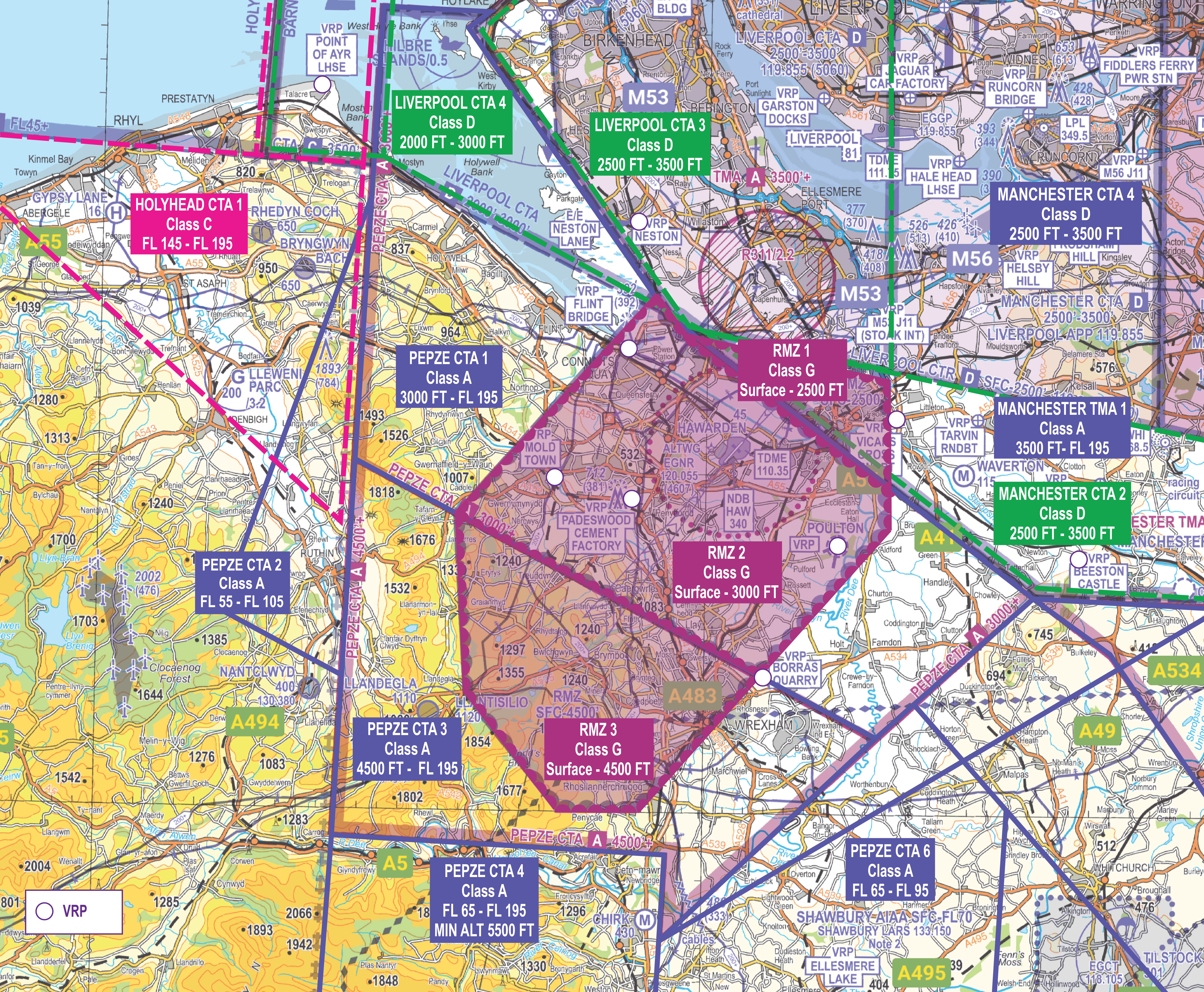
Hawarden RMZ 1, RMZ 2 and RMZ 3
RMZ Procedures
For flights within the RMZ pilots must comply with ONE of the following:
1. Establish 2-way RTF communication with Hawarden Radar (120.055 MHz) passing flight details before entering the RMZ and maintain 2-way communication with Hawarden Radar whilst operating inside the RMZ.
Flight details will comprise:
- Callsign
- Aircraft type
- Position
- Level/altitude
- Intentions of the flight.
2. Display the Hawarden Frequency Monitoring Code (FMC) of 4607 (with Mode C (ALT) if available), whilst monitoring Hawarden Radar on frequency 120.055 MHz prior to entering, and within, the RMZ.
3. Non-radio aircraft should contact Hawarden ATC by telephone (01244 522012), email ([email protected]) or by text message to 07786 208291 prior to commencing any planned flight that will enter or cross the RMZ. The aircraft registration, type, estimates and points of entry/exit, planned altitudes and duration/activity in the RMZ needs to be passed to Hawarden ATC. On receipt of this information an acknowledgement will be issued. This gives you authority to enter the RMZ.
4. Conduct flight in accordance with valid Letter of Agreement with Hawarden ATC if operating from a site within the RMZ.
Hawarden Frequency Monitoring Code (FMC)
The Hawarden FMC (commonly known as a listening squawk) is 4607. It should always be used with Mode C (ALT) if available). It is designed so you can monitor the Hawarden Radar Frequency without contacting ATC; however, you must establish two-way communication with ATC if requested. Observing the transponder code will indicate to Hawarden ATC that you are monitoring the frequency able to be contacted by ATC should the need arise.
Use of the FMC
- Monitor the Hawarden Radar Frequency of 120.055 MHz.
- Select the squawk 4607 (with Mode C (ALT) if available).
- Remember you are not receiving an Air Traffic Service.
- You remain responsible for your own navigation and terrain clearance.
- You are not cleared to enter the ATZ or any Controlled Airspace.
- You do not need to contact Hawarden Radar.
- ATC will call you if they wish to contact you. You will be called in relation to your position.
- When leaving the RMZ, deselect 4607 first and change frequency.
Visual Reference Points (VRPs)
These four VRPs can be useful in identifying the boundaries of the RMZ to assist with frequency change or selection of the FMC. We suggest pilots use the VRPs in the vicinity of Hawarden as a guide to selecting the FMC.
Outside the RMZ
- Beeston Castle lies 5.7NM to the east of the RMZ boundary near the village of Tarporley and to the south of the Shropshire Union Canal).
- Vicars Cross Roundabout lies just to the east of the RMZ Boundary to the east of the city of Chester and on the junction of the A55 and A51.
- Borras Quarry lies on the eastern RMZ boundary and to the north of Wrexham town.
- Point of Ayre Lighthouse lies 11.5NM to the northeast of the RMZ boundary and on the mouth of the River Dee to the east of Prestatyn.
Inside the RMZ there are four further VRPs to aide with maintaining situational awareness and position referencing/reporting:
Inside the RMZ
- Poulton Disused Airfield lies 0.9NM inside the RMZ boundary and to the southeast of Hawarden aerodrome.
- A494/A541 Mold Town Roundabout lies 1.4NM inside the western RMZ boundary.
- Flint Bridge lies 0.5nm inside the RMZ boundary to the northwest of Hawarden aerodrome.
- Padeswood Cement Factory lies 2.85NM inside the RMZ boundary to the southwest of Hawarden aerodorme.
RMZ infringements
Whilst there had been a year-on-year reduction in the number of reported airspace infringements of the RMZ, the numbers remain high and more than doubled to in 2024 to 19.
The major causes of RMZ Infringements appear to be a lack of understanding by pilots of the requirements for entry to an RMZ or a failure to note the area’s depiction on aviation charts. This has been particularly evident in 2024 when many of the occurrences resulted from deviation from the pilot’s initial planned route due to encountering weather along the route. In many cases, the weather conditions could have been predicted by carrying out a detailed meteorology plan using regulated information form the UK Met Office Aviation Briefing website.
Most aircraft that infringe the RMZ tend do so to the southwest of the airspace just below the Pepze CTA, base level 4,500 feet. Pilots, believing that they are routing well to the southwest of Hawarden don’t call Hawarden Radar, but end up transiting through the southwestern portion of the RMZ.
This has a significant impact on aircraft making instrument approaches to Runway 04. The RMZ provides a certain amount of protection from, and predictability for, aircraft transiting nearby. However, due to the high ground in that area radar coverage is poor and unknown traffic quite often appears late on, requiring rapid avoiding action for aircraft at a critical stage of flight, unknown traffic must be de-conflicted by either 5NM horizontally or 3,000 feet vertically. If aircraft call early to transit, co-ordination can be achieved, or inbound aircraft vectored early to pass behind the known traffic.
Guidance card
The Hawarden Radio Mandatory Zone (RMZ) guide includes a summary of the RMZ and details its requirements.
Preventing ATZ infringements at Manchester Barton Aerodrome
UPDATED 20 February 2025
This infringement update has been written by the Aerodrome Flight Information Service Officers (AFISO) at Manchester Barton Aerodrome who are members of the Northwest Local Airspace Infringement Team.
It has been updated to incorporate changes to the area of the Manchester Control Zone that was formerly the Manchester Low Lever Route and is now the Class G Restricted Area EGR323 – North West Transit Corridor.
ATZ infringements
Whilst ATZ infringements have always been reportable as an occurrence (a breach of Rule 11 of The Rules of the Air Regulations 2015), the national focus on airspace infringement prevention and improved reporting have identified a number of common factors which have led to such infringements.
In 2024 there were 95 reported infringements of ATZs in the UK. This type of airspace infringement is a particular risk to the operation at Manchester Barton Aerodrome. This article is intended to give helpful guidance and useful tips to assist pilots in preventing an ATZ infringement at the Aerodrome and may also be relevant at other ATZs elsewhere.
An ATZ is established to give protection to aircraft at the critical stages of flight when departing, arriving, and flying in the vicinity of the aerodrome and it can be a busy area of airspace. Barton is an aerodrome used by many aircraft which vary greatly in performance levels; compliance with Rule 11 of the Rules of the Air Regulations 2015 is essential to ensure that the ATZ’s protection is an effective mitigation against a mid-air collision.
The Barton ATZ
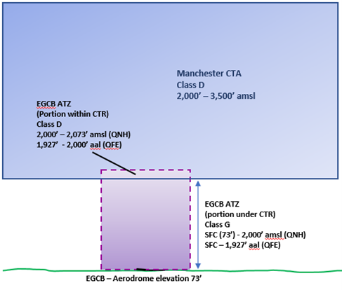
The Barton ATZ has a 2NM radius and extends to 2,000 feet above aerodrome level. It sits underneath the Manchester Control Area (CTA) with vertical limits of 2,000 feet – 3,500 feet AMSL (based on the Manchester QNH) and against the Manchester CTR which itself extends from the Surface to 3,500 feet AMSL (based on the Manchester QNH) as depicted below. The ATZ it is a non-standard ATZ as it excludes the portion of the circle that would lie within the Manchester CTR. The ATZ is active during the published hours of the Aerodrome Flight Information Service as per the entry in the UK AIP at EGCB AD 2.17.
The ATZ lies primarily within Class G airspace; however, the top of the ATZ lies above the base of the Class D Manchester CTA (Manchester Barton aerodrome elevation being 73 feet AMSL). This also means that it is impossible to transit at the top height (2,000 feet AGL) or above the Barton ATZ without clearance from Manchester ATC. Aircraft arriving to and flying visual circuits at Barton will do so on the Barton QFE; departing aircraft will be issued the Manchester QNH.
Extract from: Sheet 5 Central England and Wales Edition 14 (2021)
Reported infringements and local awareness
Each year, most of the infringements involved aircraft that were inbound to land with a small number by aircraft not landing but flying within the vicinity.
Manchester Barton Aerodrome is a member of the Northwest Local Airspace Infringement Team (LAIT). Significant local awareness and education material has resulted in a large reduction in the number of infringements involving locally based aircraft. This information aims to further extend this awareness and educate pilots around the country who may be visiting the aerodrome or passing the vicinity.
Common causal factors
A study of the infringements breaks down the majority of causal factors into the following areas:
Lack of awareness of Rule 11 – A number of pilots were unaware that they must not enter the ATZ (even if they have previously remained on frequency in the local area) until the AFISO has passed updated aerodrome information directly to them. Most incidences cited busy RTF as a contributary factor, with the PIC not able to make an initial joining call to obtain airfield information, or having been asked to “standby” due to AFISO workload. See the below section Plan Ahead for guidance.
Further information on Rule 11 and ATZs can be found in this leaflet.
Incorrect frequency selection – Barton Information frequency is 120.255 MHz and has a Designated Operational Coverage (DOC) of 10NM radius and up to 3,000 feet amsl. The second most common cause for Barton ATZ infringements is incorrect frequency selection and pilots continuing their flight into the ATZ having not received a response. Rule 11 applies to aerodromes with a Flight Information Service (FIS) centre during the notified hours of watch of the FIS unit as notified in the UK AIP or as amended by NOTAM. If you don’t receive a response during these hours, check your frequency selection and avoid the ATZ entirely.
Lack of pre-flight planning – It was evident that in some cases, non-Barton based aircraft transiting or operating within the immediate local area had not completed an adequate pre-brief for their intended flight. In some cases, these aircraft had also not completed PPR.
Distraction – The pilot may have been distracted, either by passengers or whilst under instruction, in the latter cases allowing the student to continue to infringe without taking preventative or corrective action in good time.
Tips on preventing ATZ infringements at Barton
Several local VRPs are established in the vicinity of the aerodrome which may provide assistance in judging a suitable distance at which communications and aerodrome information should be established and received.
Inbound from the Southwest
When routing via the North West Transit Corridor, it is important to remember that the Barton DOC is 10NM so pilots should not call the AFISO unit prior to crossing the M56. The base of CTA 6 is 1,500 feet AMSL so pilots should be aware that setting the Barton QFE and adjusting their altitude too early for an overhead join may result in an infringement of the CTA. If you are unable to establish 2-way communications AND comply with the requirements for Rule 11, you should plan to remain at least 2NM from the ATZ boundary by routing northbound towards Hulton Industrial Estate VRP.
Inbound from the Northwest, North and Northeast
A good place to make your initial call is in the vicinity of VRP’s at Winter Hill Mast, Middlebrook Stadium or M60/M62/M66 Heaton Interchange. These all allow 5+ nm before reaching the ATZ.
Transiting Southwest to Northeast and reverse
The aerodrome and ATZ can become extremely busy. Should a transit of the ATZ be necessary, ensure that a call is made in good time at least 5 miles before reaching the boundary to allow you to receive aerodrome and specific traffic information to conduct your transit safely. We would suggest, when busy, that it may be more prudent to remain at least 3-4 nm from the Aerodrome, therefore well outside the ATZ, and route around via the West and North side of the ATZ. The Barton AFISO can provide a basic service and will advise of any traffic that may be of relevant to your routing.
Plan ahead
Especially during busy periods, the frequency may be busy and so sufficient time should be allowed in order to establish two-way communication and aerodrome information. If you are asked to standby, you must not enter the ATZ; in addition, it would be best practice not to orbit immediately adjacent to the ATZ, so, where possible, an early call ten miles out will be beneficial. Have a backup plan should you be unable to establish contact. This may involve re-routing or holding within the local area, being careful of other airspace in the vicinity.
Use a Moving map
A VFR moving map display, with audio alerts enabled, will give you a good clear indication of the ATZ and adjacent airspace giving you the ability to maintain situational awareness. Ensure your alerts are configured correctly as it is possible to disable alerts for certain airspace types such as ATZs.
Transponder Code
When in communication with Barton Information, aircraft can be expected to be allocated a specific transponder code. This code is designed to assist adjacent radar equipped ATC units in identifying any aircraft that are in communications with the Barton AFISO, enabling improved and swift resolution should any infringements of the Manchester or other nearby airspace occur. Aircraft should not select the Barton conspicuity code without first being instructed to do so by the AFISO.
Relevant Traffic Information
The AFISO is responsible for providing traffic information to aircraft within the ATZ and immediate vicinity. Therefore, by ensuring a timely call to the AFISO with accurate position and height well before entering the ATZ, they are then able to provide a much more complete ‘picture’ of relevant traffic to both yourself and other aircraft in or near the ATZ, assisting all pilots in situational awareness and reducing risk of collisions.
Barton operates an ADS-B Flight Information Display (FID) in line with CAP 797 (Appendix F). This helps provide the AFISO with additional situational awareness and provides a further tool in which the AFISO can help pilots avoid ATZ or other controlled airspace infringements as long as their workload permits.
Local Procedures
The overhead join height is 1700 feet AGL. This aims to give separation from the Manchester CTA above and in the vicinity of the aerodrome reducing potential for inadvertent vertical infringements of the Manchester CTA. Circuit height is 1000 feet AGL.
Further information, local procedures and online PPR can be found online at: www.bartonaerodrome.co.uk
Preventing airspace infringements in the vicinity of East Midlands
This infringement update is the eighth in a series of narratives focusing on identified hot-spots in the UK. The original was written by members of the Midlands LAIT including East Midlands Air Traffic Control and operators at Nottingham Aerodrome and was first issued in January 2020, followed by an update in 2021 and the most recent update in 2024.
The East Midlands airspace comprises 2 Control Zones (CTRs) and 22 Control Areas (CTAs). The Midlands LAIT has noted that a significant ‘hot-spot’ exists for airspace infringement of the East Midlands CTA-2.
In 2023, there were 62 reported infringements of East Midlands controlled airspace; a total increase of 138% compared with 2022. Of the 62 infringements in 2023, 24 were of East Midlands CTA-2, making up 39% of all infringements in 2023.
Out of the 24 East Midlands CTA-2 infringements, 38% required safety Intervention measures by ATC with one infringement resulting in a loss of separation against an inbound aircraft. In the context of airspace infringements, a safety intervention measure is an action by ATC to assure safety and separation such as, but not limited to, avoiding action, radar vectors and suspension of departures.
East Midlands CTA-2
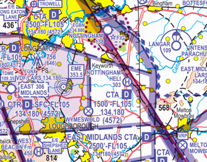
Figure 1 – Correct at 1:500k South Edition 49
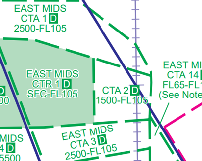
Figure 2 – Correct at AIRAC 01/24
East Midlands CTA-2 is Class D controlled airspace located to the east of the airport with a base of 1,500 feet AMSL (based on East Midlands QNH) and extends to FL105. The northern boundary lies approximately 3NM south of Nottingham Aerodrome (and approximately 1NM south of the Nottingham Aerodrome Traffic Zone (ATZ) boundary) and it is bisected by the A46 which runs south-north from Leicester.
Arriving and Departing Nottingham Aerodrome
Nottingham Aerodrome is located approximately 10NM northeast of East Midlands Airport underneath East Midlands CTA-1 (base 2,500 feet on East Midlands QNH to FL105). Nottingham ATZ is notified in the UK AIP AD EGBN as a circle, 2NM radius from Surface to 2,000 feet AGL (2,138 feet AMSL). The aerodrome is serviced by an Air/Ground Communication Service (Nottingham Radio) on 134.880 MHz. Runways are oriented 27/09 and 21/03 with left hand circuits.
The preferred method of joining the circuit is via the standard overhead join at 2,000 feet on Nottingham QFE. Pilots are requested to not initiate a climb to 2,000 feet on Nottingham QFE too early. Instead, it is recommended to remain on East Midlands QNH when climbing beneath controlled airspace to allow for pressure differences and to increase your situational awareness as to your vertical position to controlled airspace.
When outbound, pilots will be given the East Midlands QNH. When departing southbound, it is important to remember to ‘level-off’ below 1,500 feet on the QNH to avoid infringing East Midlands CTA-2. If possible, ‘level-off’ and trim the aircraft at 1,300 feet to incorporate the ‘Take 2’ guidance, allowing 200 feet from the base of controlled airspace.
Langar Activity
Langar parachute site is located approximately 16NM east northeast of East Midlands Airport and 3NM northeast of the eastern boundary of East Midlands CTA-2. It is notified in the UK AIP ENR 5.5 as a circle, 1.5NM radius from Surface to FL150.
It is important to establish the activity status of the parachute site during the pre-flight planning stages and again when en-route by contacting Langar on 129.905 MHz or alternatively requesting a status from East Midlands Radar on 134.180 MHz or London Information on 124.600 MHz.
You are recommended to ensure that you have a contingency plan that notes the base of East Midlands CTA-2 so that should Langar become active mid-flight, you are able to route around the site without entering controlled airspace. If routing to the west of Langar, pilots should plan to remain below CTA-2 unless in receipt of a CTA crossing clearance from East Midlands Radar. If possible, consider routing to the east of Langar where there is less controlled airspace, and the risk of infringing is reduced. In routing to the east, it is important to note that winch launch gliding activity takes place as Saltby with winching to 3,500 feet AMSL and intense gliding activity in the area.
Visual Reference Points (VRPs)
East Midlands Airport has 6 VRPs; of which four are in the vicinity of the eastern half of the controlled airspace structures as follows:
Melton Mowbray VRP (Disused Aerodrome) (Figure 3) – Located approximately 17NM east southeast of East Midlands Airport. Pilots inbound to Nottingham aerodrome from the VRP on a direct track will need to descend to below 1,500 feet on the East Midlands QNH or be in receipt of an air traffic clearance to enter controlled airspace to avoid infringing East Midlands CTA-2.
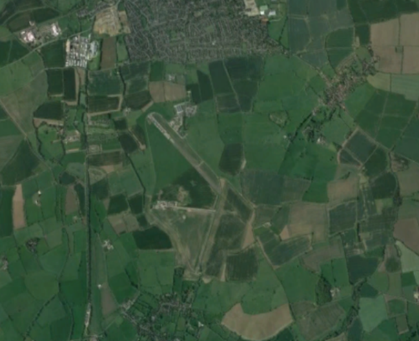
Figure 3 – Melton Mowbray VRP
Bottesford VRP (Disused Aerodrome) (Figure 4) – Located approximately 22NM east northeast of East Midlands Airport. Pilots routeing via Bottesford VRP should avoid overflying the area around Langar aerodrome, which is designated as an area of intense parachuting activity.
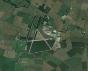
Figure 4 – Bottesford VRP
Trowell (Motorway M1, Service Area) VRP (Figure 5) – Located approximately 8NM north of East Midlands Airport. It lies underneath the Class D East Midlands CTA-1 where the base of controlled airspace is 2,500 feet on East Midlands QNH. Pilots not in receipt of a clearance to enter controlled airspace should remain below the base of CTA-1.
Figure 5 – Trowell VRP
Markfield (Motorway M1, Junction 22) VRP (Figure 6) – Located approximately 8NM south of East Midlands Airport. It lies underneath the Class D East Midlands CTA-4 where the base of controlled airspace is 2,500 feet on East Midlands QNH. Pilots not in receipt of a clearance to enter controlled airspace should remain below the base of CTA-4.
Figure 6 – Markfield VRP
East Midlands Operations
An aircraft that enters controlled airspace without a clearance is, to air traffic control, an unknown aircraft and a separation standard of either 5NM laterally or 5,000 feet vertically must be achieved between that aircraft and IFR aircraft inbound to, or outbound from, East Midlands.
Figure 7 shows East Midlands Runway 09 Departure Routes. The red area is typically used by aircraft below 6,000 feet.
Figure 7 – East Midlands Runway 09 Departure Routes
Figure 8 shows East Midlands Runway 27 Arrival Routes. The red area is typically used for Continuous Descent Approaches below 6,000 feet.
Figure 8 shows East Midlands Runway 27 Arrival Routes
An infringement of East Midlands CTA-2 may result in ATC having to issue safety intervention measures to ensure separation is maintain between the unknown aircraft and any IFR traffic. In some cases where 5NM or 5,000 feet cannot be maintained, a Loss of Separation occurs. All infringements carry a safety risk, increase controller workload and impact the airport and airline operations.
Preventing an Airspace Infringement
To prevent an airspace infringement, as part of their pre-flight planning and in-flight execution, pilots are strongly encouraged to:
Obtain a Lower Airspace Radar Service from East Midlands. Pilots can obtain a Lower Airspace Radar Service (LARS) from East Midlands radar on 134.180 MHz when within 30NM of East Midlands Airport; the hours of operation are H24.
Use the Frequency Monitoring Code (FMC). Rather than squawking 7000, if you do not want to obtain a service from ATC, make use East Midlands FMC by squawking 4572 and monitoring 134.180 MHz. Obtain the East Midlands QNH by asking an adjacent ATS unit or by listening to that given to other aircraft on 134.180 MHz. It may also be obtained through the ATIS on 122.680 MHz.
Use a VFR Moving Map in conjunction with a paper chart to provide a profile along your planned route showing controlled airspace above and below your route. Insert waypoints to show descent and climb points that are built into your plan, incorporating Take 2 wherever possible and enable airspace warnings to help identify airspace when in close proximity.
Avoid flying on the Regional Pressure Setting (RPS) in the vicinity East Midlands CTAs or below the DTY CTA. When flying on the RPS, as it is the forecast lowest QNH for a region, you will be higher in relation to the East Midlands QNH. If you are receiving a FIS from London Flight Information Service, ask the FISO for the East Midlands QNH rather than remaining on the Barnsley RPS.
More information
Solent CTA-3 and CTA-5 airspace infringement hot-spot
This infringement update is the ninth in a series of narratives focusing on identified infringement ‘hot-spots’ in the UK. It has been written by members of the Solent LAIT, Southampton Airport and Southampton Air Traffic Control.
The Solent airspace comprises the Southampton Control Zone (CTR Surface to 2,000 feet amsl) and 8 Solent Control Areas (CTA). This airspace is designated as Class D controlled airspace.
The CTA-3 portion of the Solent CTA extends from 2,000 feet to 5,500 feet while the CTA-5 portion extends from 2,500 feet to 5,500 feet (highlighted in red below – figure 1). In 2019 Southampton/Solent airspace was subject to 91 airspace infringements. At least 14 of these infringements involved either one or both of these two areas. This is significant because these two areas only make up a small fraction of the total Solent CTA and the impact of infringements here creates a high risk of a loss of separation.
Analysis of the infringements shows most aircraft infringe by cutting corners and enter controlled airspace by crossing the line. However, there are also a significant number of infringements that occur by aircraft ‘climbing’ into the CTA while routing under the area. This latter type of infringement, particularly in this area, can have more major consequences.
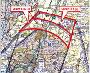
Figure 1: Solent CTA-3 and CTA-5
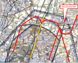
Figure 2: Final approach track for the Runway 20 ILS at Southampton
Figure 2 shows the final approach track for the Runway 20 ILS at Southampton (depicted in yellow). The red lines in Figure 2 show the typical approach path of inbound IFR traffic. When vectoring for the Runway 20 ILS approach, controllers are instructing IFR aircraft to turn and descend in order to intecept the final approach path at about 8 nautical miles from touchdown and at an altitude of 2500ft.
Most IFR aircraft (usually commercial/scheduled) are flying at around 180KTs – so covering 1NM every 20 seconds. Given the confines of the airspace this means that the timing of turns is critical – especially when making allowance for the wind on the day. Often the controllers are not only ensuring the commercial traffic are kept inside controlled airspace but also sequencing them between traffic ahead and traffic behind. This means a high degree of accuracy is required.
Commercial aircraft can be operating 500 feet above the base of controlled airspace. Although there are other approaches to Runway 20 at Southampton, over 95% use the ILS approach. ATC will descend IFR aircraft to 500 feet above the base of controlled airspace (as is standard operating procedure). Any infringement of the CTA-3 or CTA-5 here can rapidly cause a loss of separation which has serious implications for all concerned. The controller would have to take mandatory avoiding action and a full investigation would be carried out into the incident. The controller is then unable to continue working until a preliminary investigation is complete.
An infringing aircraft that is not radar identified by Solent Radar becomes unknown traffic; a separation standard of 3nm laterally or 3,000 feet vertically is required between that aircraft and IFR aircraft inbound to, or outbound from, Southampton Airport or operating within Southampton/Solent controlled airspace.
The New Alresford VRP exists underneath the CTA-5 which has a base of 2,500 feet and this VRP is commonly used by aircraft routing around the Solent CTA to the northeast.
Important factors to think about when flying under the CTA -3 and CTA-5
- Take 2. An initiative through the Local Airspace Infringement Teams (LAIT) is to Take 2. By remaining at least 200 feet below the base of the area (or 2nm horizontally away from the edge of the Control Zones) then, any inadvertent deviation from level flight or planned course could be caught in sufficient time to prevent an airspace infringement. As mentioned in the introduction, it is especially important when flying ‘under’ these Solent control areas. A radar controller can usually see traffic operating beneath controlled airspace while controlling inbound traffic to Southampton and has to expect such aircraft to remain outside controlled airspace. Any vertical deviation that results in an aircraft entering the CTA (without a clearance) can immediately cause a loss of separation with the aircraft within, which quickly becomes a significant safety event employing actual and tactical avoiding action, creating a highly elevated workload with yet greater risk and resulting in all the reporting action and investigation that that entails. If you just ‘pop up for a moment’ it can easily be as significant as a horizontal one from an ATC perspective.
Download TAKE2 - Set the correct QNH. The base of controlled airspace is determined by the local ‘Solent’ QNH, not the local regional pressure setting (RPS). A difference of 3-4 HPa is not unusual and aircraft flying close to the base can inadvertently infringe just by having the wrong (inappropriate) QNH selected.
Download Altimetry Key tips - Use the appropriate Frequency Monitoring Code (FMC) and listen out. The airspace below the CTA-3 and CTA-5 is Class G airspace (uncontrolled). There is no requirement to receive a service from Southampton ATC (the controlling authority). However, the introduction of the FMC (7011 for Southampton/Solent Radar – 120.230MHz) enables ATC to observe an aircraft that may be of potential conflict to their traffic inside controlled airspace, and then call such an aircraft when appropriate. Once communication is established, and the aircraft is identified, the potentially infringing aircraft becomes known traffic to the controller, enabling tactical planning or incident recovery to be completed quickly. Use of this FMC has been proven to prevent infringements and reduce the severity of such occurrences as well as enhance the controllers’ and pilots’ situational awareness creating a safer and more predictable situation than would otherwise prevail.
Download Listening squawks - If appropriate – request a clearance. If for any reason a climb is required above the base of controlled airspace (2,000 feet for CTA-3, 2,500 feet for CTA-5), then a clearance must be obtained. Depending on a variety of factors, not least the runway in use and traffic situation at the time, this may well be available. By obtaining a clearance to enter controlled airspace when appropriate, ATC are able to control more effectively and ensure safety is maintained.
Download R/T – Prepare your transmissions - Always use a moving map. There are many reasons why a pilot can lose situational awareness of his/her position that may then result in an airspace infringement. Whether flying recreationally or carrying out an instructional flight, the correct use of a moving map is known to reduce that risk and assist in increasing pilot capacity.
Preventing airspace infringements in the vicinity of Farnborough Controlled Airspace
This infringement update has been written to provide pilots with a comprehensive guide to the Class D and Class E Farnborough controlled airspace to assist in the prevention of airspace infringements.
Farnborough Airport’s RNAV instrument flight procedures for departures and arrivals, utilising RNAV1 and RNAV5 navigation specifications are contained within controlled airspace (CAS) in the form of two Class D Control Zones (CTR) around the aerodrome, seven Class D Control Areas (CTAs) and two Class E Control Areas. The Class E airspace is a Transponder Mandatory Zone (TMZ). A speed limit of 250 knots IAS applies below FL100.
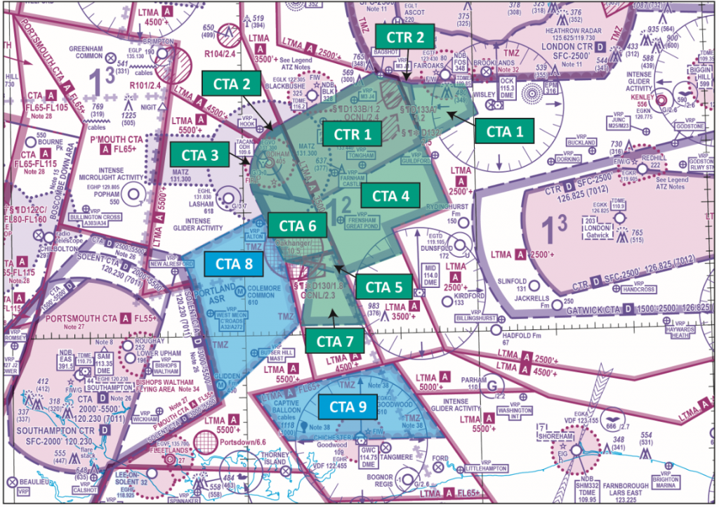
Figure 1: Farnborough CTR/CTA
| Structure | Vertical Limits | Classification |
| CTR 1 | SFC-3500 feet | Class D |
| CTR 2 | SFC-2500 feet | Class D |
| CTA 1 | 2000-2500 feet | Class D |
| CTA 2 | 1500-5500 feet | Class D |
| CTA 3 | 2000-5500 feet | Class D |
| CTA 4 | 2500-3500 feet | Class D |
| CTA 5 | 2500-4500 feet | Class D |
| CTA 6 | 2500-5500 feet | Class D |
| CTA 7 | 3500-4500 feet | Class D |
| CTA 8 | 4500-5500 feet | Class E with TMZ |
| CTA 9 | 5500 feet-FL65 | Class E with TMZ |
| Class A overlies CTA 9 at FL65 and above regardless of QNH | ||
Airspace access and responsibilities
Class D Controlled Airspace: CTRs 1 & 2, and CTAs 1 – 7
- IFR and VFR flights are permitted within all Class D airspace; SVFR flights are permitted in Class D CTR. An ATC clearance is needed and compliance with ATC instructions is mandatory.
- Aircraft operating IFR or SVFR are separated from each other and are given traffic information in respect of VFR flights, traffic avoidance advice is available upon request. Flights operating under VFR are given traffic information in respect of all other flights and traffic avoidance advice is available upon request.
Class D VMC Criteria (VFR Minima)
| Altitude Band | Flight Visibility | Distance from Cloud |
| Below FL100 and above 3,000 ft AMSL, or above 1,000 ft above terrain, whichever is the higher. | 5km | 1,500m horizontally and 1,000 feet vertically |
| At and below 3,000 ft AMSL, or 1,000 ft above terrain, whichever is the higher. | 5km | 1,500m horizontally and 1,000 feet vertically |
| Alternative, at and below 3000 ft AMSL when transiting class D airspace (flying at 140 kt IAS or less) and remaining outside the aerodrome traffic zone or aerodrome traffic circuit. | For aircraft, other than helicopters 5 km.
For helicopters 1,500 m |
Clear of cloud and in sight of the surface |
Class E Controlled Airspace: CTAs 8 & 9
- Class E airspace is controlled airspace. Compared with Class G airspace, there is a greater likelihood of encountering faster and heavier aircraft types within Class E airspace.
- IFR flights must obtain an ATC clearance to operate within Class E airspace as with other controlled airspace classifications.
- IFR flights are separated from other IFR flights and receive traffic information as far as practicable on VFR flights and when receiving a surveillance-based Air Traffic Service (ATS), traffic avoidance advice will be provided whenever practicable or when requested.
- ATS providers (Farnborough, London Terminal Control and Solent Radar) are not responsible for providing separation between IFR and VFR flights within the two Class E CTAs.
- Unlike other controller airspace classifications, pilots operating VFR are not issued with an ATC clearance to operate within Class E airspace.
- Pilots operating VFR within Class E airspace are not required to receive an Air Traffic Service, but it is recommended that such pilots seek to obtain a Basic Service or a Traffic Service (see CAP 774) from Farnborough ATC when operating in either CTA 8 or 9.
- Pilots of VFR flights are responsible for collision avoidance irrespective of whether an ATS (UK FIS) is provided.
- Farnborough Class E airspace is additionally notified as a Transponder Mandatory Zone (TMZ). Regardless of flight rules used, all aircraft within the TMZ must be equipped with Mode S transponders with altitude reporting, or if unable to meet the transponder requirements, obtain an approval (for lack of equipage) to enter TMZ airspace from the controlling ATS Unit prior to entry. An approval is not a clearance.
- Pilots intending to operating VFR within Class E airspace that is additionally notified as TMZ (i.e. CTA 8 & 9) must prior to entry either display:
- the appropriate Frequency Monitoring Code (FMC) for that volume of airspace; or
- the VFR conspicuity squawk (7000) with altitude reporting; or
- Pilots that are unable to meet the transponder requirements, should establish communication with the controlling ATS unit and obtain an approval to enter Class E airspace.
- Pilots may utilise the FMC for Solent (7011), Farnborough (4572) or Gatwick (7012) when monitoring the relevant frequencies within Class E airspace, however they must remain VFR at all times.
- Pilots already operating in accordance with VFR within CTAs 8 or 9 and subsequently wish to operate in accordance with IFR in these CTAs, must continue to operate VFR until an IFR clearance has been obtained.
Class E VMC Criteria (VFR Minima)
| Altitude Band | Flight Visibility | Distance from Cloud |
| Below FL100 and above 3,000 ft AMSL, or above 1,000 ft above terrain, whichever is the higher. | 5km | 1,500m horizontally and 1,000 feet vertically |
Controlled Airspace Transits
Pilots requesting to transit Class D airspace should call Farnborough Radar on channel 133.440 .
Pilots wishing to transit Class E airspace (CTA-8 and CTA-9) under VFR in communication with ATC should call Farnborough LARS on 125.250 MHz pilots wishing to transit under IFR should call Farnborough Radar on channel 133.440.
An aircraft that enters Class D airspace or Class E Airspace under IFR without a clearance is, to Air Traffic Control, considered to be an unknown aircraft and a separation standard of either 3NM laterally or 3,000 feet vertically must be achieved between that aircraft and IFR aircraft inbound to, or outbound from, Farnborough Airport.
Other Aerodromes
Blackbushe Airport lays to the north of CTR-1; part of its ATZ lies within the Class D CTR. Operational interactions with Farnborough Airport, and Local Flying Area procedures are specified in UK AIP AD2 EGLK-2.22 Flight Procedures.
(For more information on Blackbushe see ’19. Farnborough Controlled Airspace: Blackbushe Airport’)
Fairoaks Aerodrome IFR inbounds from the ATS route network will route via a Farnborough standard arrival route (STAR). Outbound aircraft will be managed in accordance with information specified in UK AIP AD2 EGTF-2.22 Flight Procedures. Fairoaks airfield southerly departures need to be aware of possible ACAS events against Farnborough IFR arrivals in CTA-1.
(For more information on Fairoaks see ’40. Focus on Fairoaks – Preventing Infringements in the vicinity of Farnborough’)
Farnborough controlled airspace may additionally include IFR operations from RAF Odiham, Lasham, Dunsfold, Goodwood and Shoreham aerodromes.
Royal Flights
A NOTAM will be issued to promulgate the reclassification of the Class E CTA-8 and/or CTA-9 as Class D CAS when Royal Flights are arriving/departing Farnborough aerodrome.
VFR pilots are to be aware of the change in airspace classification due to any Royal Flight activity in this area.
Visual Reference Points (VRPs)
When planning to transit any CAS, it is essential that as part of your pre-flight planning, you are aware of the VRPs relevant to that airspace, know what the VRPs look like and consider the likely routings and or/holding points that may be used employing them. In many infringement events it has been found that pilots do not know the location of many of the VRPs when relying upon them for point-to-point transits or as holding points. As part of pre-flight planning, use applications like Google Earth to familiarise yourself with that to expect to see on the ground and use your VFR chart to decide where and how you will hold if you are issued a clearance limit of one of the VRPs.
Farnborough has ten VRPs to assist in the provision of air traffic services to aircraft operating in the vicinity of Farnborough as follows:
M3 Junction 3 lies within the London Control Zone (CTR) and is clearly visible as the circular junction of the M3 and A322 (FIGURE 2).
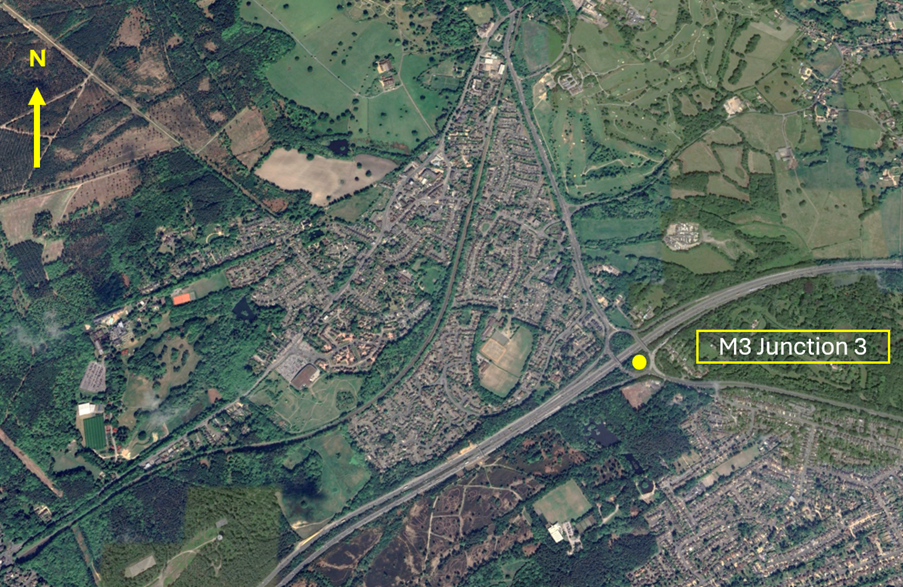
Figure 2 – M3 Junction 3 VRP
Bagshot VRP lies on the southwestern edge of the London CTR and is to the southwest of Bagshot town. When viewed from the air it is on the northside carriage of the M3 motorway on the portion of the road where the carriageways divide around a slip of woodland to the southwest of the M3 Junction 3. (FIGURE 3).
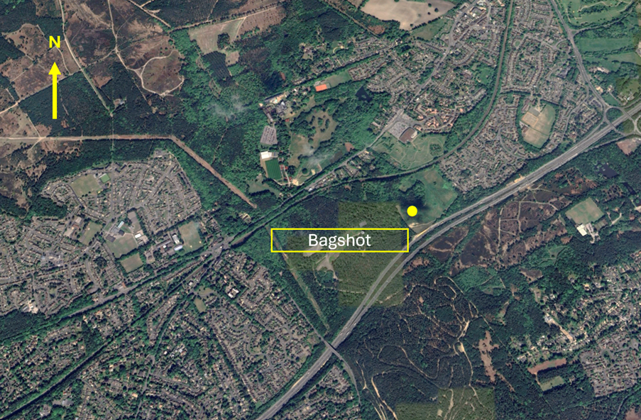
Figure 3 – Bagshot VRP
M3 Junction 4 lies within the Farnborough CTR-1 and is clearly visible between the towns of Frimley, Camberley and Farnborough (FIGURE 4). In addition to aircraft transiting north/south through Farnborough CAS, this VRP is used as a standard VFR departure from Blackbushe Airport not above 2,000 feet. When issued with a Standard M3 Junction 4 Departure by the FISO unit at Blackbushe Airport, you will be expected to hold north of the VRP and contact Farnborough Radar on channel 133.440.
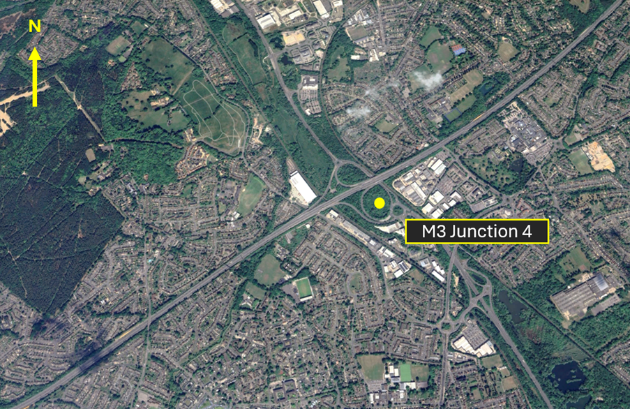
Figure 4 – M3 Junction 4 VRP
Fleet Pond VRP is the pond to the northwest of Farnborough Airport laying to the south of the M3 and inside the Farnborough CTR-1 (FIGURE 5). In addition to aircraft transiting East/West through Farnborough CAS, this VRP is also used as a standard VFR departure from Blackbushe Airport not above 2,000 feet. When issued with a Standard Fleet Pond Departure by the FISO unit at Blackbushe, you will be expected to hold northwest of the VRP and contact Farnborough Radar on channel 133.440.
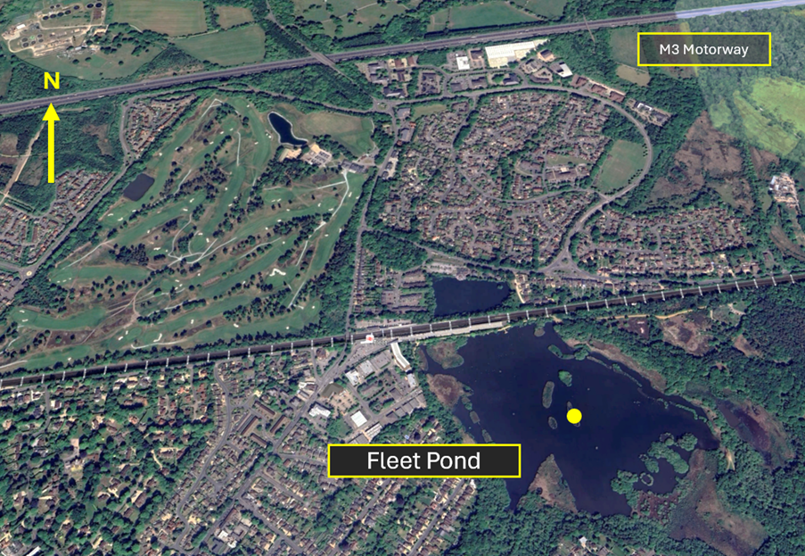
Figure 5 – Fleet Pond VRP
Hook Railway Station VRP can be identified as the bridge crossing the track at Hook railway station (FIGURE 6). It lays in Class G airspace to the northwest of the Farnborough CTR-1 and just to the north of the RAF Odiham ATZ.
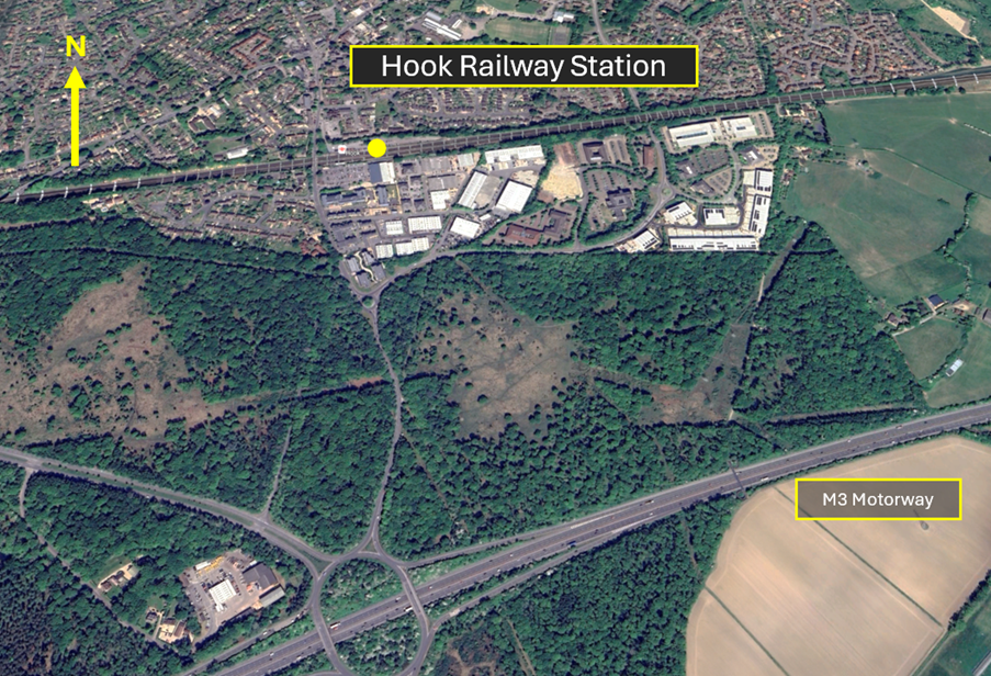
Figure 6 – Hook Railway Station VRP
Guildford Railway Station VRP is the railway station at Guildford (FIGURE 7). It lays in Class G airspace to the east of the Farnborough CTA-4 (2,500 feet to 3,500 feet AMSL) and to the south of CTA-1 (2,000 feet to 2,500 feet AMSL). When issued with a clearance limit at this VRP you should remain south and east of the town and River Wey to avoid entering the CTRs.
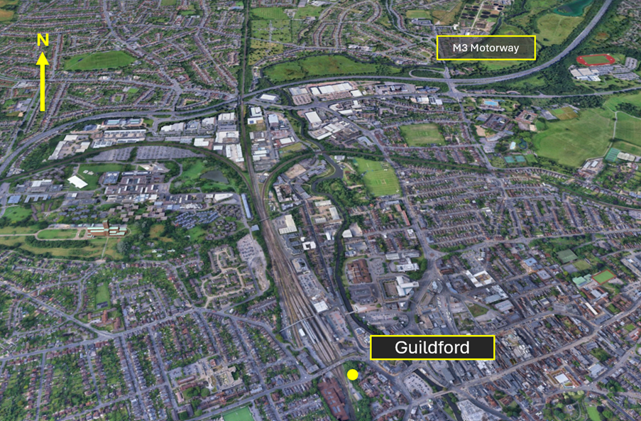
Figure 7 – Guildford Railway Station VRP
The A31 Tongham Roundabout VRP is the prominent traffic roundabout on the A31/A331 south of Aldershot and west of the part of the A31 known as the Hog’s Back (FIGURE 8). It is located within the Farnborough CTR-1.

Figure 8 – A31 Tongham Roundabout VRP
Approximately 2.5NM to the west southwest of the A31 Tongham Roundabout VRP, and also inside the Farnborough CTA-1 is the VRP of Farnham Castle (FIGURE 9). This VRP lays just to the north of Farnham and is a distinctive series of red brick/red roofed buildings with a building inside a walled grass circular area.
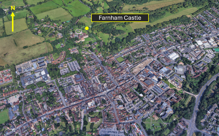
Figure 9 – Farnham Castle VRP
Underneath CTA-4 (2,500 feet -3,500 feet AMSL) lays the Frensham Great Pond VRP (FIGURE 10). It can be found midway between Haslemere and Farnham and on the western edge of the A287.
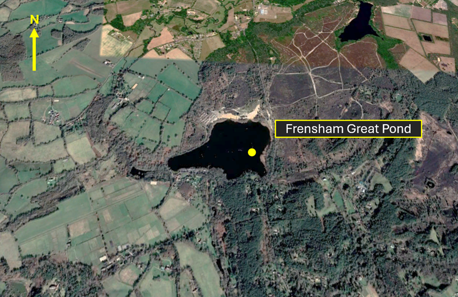
Figure 10 – Frensham Great Pond VRP
The final Farnborough VRP is the railway station at Alton (FIGURE 11). The town of Alton lays to the west of CTA-6 (2,500 feet – 5,500 feet) and on the southern edge of the RAF Odiham MATZ and approximately 3NM southeast of Lasham aerodrome. When planning to use this VRP, you should be aware of intense gliding with winch- launch activity up to 3,700 feet amsl (3,000 feet agl) at Lasham and the ATZ at RAF Odiham 3NM to the north.
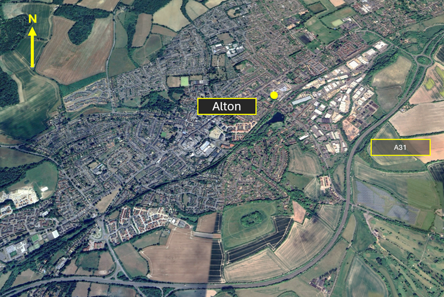
Figure 11 – Alton VRP
Obtaining and Reading Back of Clearances
The Skyway Code offers great guidance for increasing the chances of successfully obtaining a transit as follows:
Giving the controller reasonable time to respond to your request. Where possible, 10 minutes flying time from the intended entry point is ideal. If you are part of a planned ‘fly out’ where there are multiple aircraft looking to transit the airspace, apply good airmanship in considering the wider picture. SKYbrary defines airmanship as “the consistent use of good judgment and well-developed skills to accomplish flight objectives. This consistency is founded on a cornerstone of uncompromising flight discipline and is developed through systematic skill acquisition and proficiency. A high state of situational awareness completes the airmanship picture and is obtained through knowledge of one’s self, aircraft, environment, team and risk.” This can be achieved by:
- Staggering departures to allow time for each aircraft to arrive at the airspace at different times (why not allow plan for the faster aircraft to depart first?);
- Planning different holding areas in the event that clearances may take time to obtain and anticipate that the issuing of transit clearances will be subject to delay (this will also reduce the risk of mid-air collision);
- Remembering that other aircraft will also be looking to transit the airspace at the same time as your ‘fly out’. Today you may be one of 5 or 6 aircraft planning to cross the CTR, tomorrow you could be a flying on your own when there is another ‘fly out’ trying to do the same as you.
Sounding professional on the radio by clearly and concisely articulating your request. Use the standard format in Chapter 6: Approach Phraseology of CAP413- Radiotelephony Manual. This will give the controller the confidence that you can be relied on to comply with the conditions of the clearance. Remember that you cannot enter CAS until a clearance has been obtained and readback correctly. Part of the readback MUST include the flight rule under which you are operating. (FIGURE 12); a failure to readback the clearance verbatim will result in a request to read it back again thereby delaying the entry into CAS and will also add to frequency congestion.
Figure 12
Plan for a transit that seems likely
If the controller is busy, it is unlikely that a transit that would be given that crosses the final approach track at a similar altitude to that of arriving aircraft. However, a transit high above the traffic flow at right angles is much more likely to work. Crossing through the aerodrome overhead or just downwind of the arrival threshold can often be accommodated.
If a transit is not forthcoming, positively alter course away from the airspace and monitor your Moving Map to ensure that you remain clear of the airspace. Knowing the airspace and associated VRPs is an essential part of pre-flight planning.
Aircraft Flying in the vicinity of Farnborough CAS
The Airspace & Safety Initiative website provides extensive advice on how to avoid the risk of infringing airspace. You are strongly encouraged to:
- Use a VFR Moving Map. In many airspace infringements, pilots were either found not to be using a VFR Moving Map or not using one correctly. This was particularly evident during instructional flights where instructor workload is high and distractions highly likely. Using Moving Maps not only gives pilots a profile along the planned route showing controlled airspace above and below the route, but it offers airspace warnings. Moving Map technology should not be the sole means of planning or navigation as highlighted in the European General Aviation Safety Team’s Safety Promotion Leafletand the UK CAA Safety Sense leaflet.
- When flying in proximity to controlled airspace, and able to, pilots are strongly encouraged to apply the Take 2 guidance and operate on the most appropriate altimeter setting when operating under a CTA. In the case of the Farnborough CTA-1, the Farnborough or London QNH are all acceptable. Consider increasing this distance in cases of thermic or turbulent conditions or where you lack experience or are subject to skill fade. The ‘Take 2’ initiative is neither a buffer based on State policy, nor is its application mandatory; it is merely guidance based on the principle of good airmanship, introduced by pilots to help their fellow pilots and other airspace users.
- Understand the impact of forecast weatheron your flight. Thermic or turbulent conditions can inadvertently push you upwards. Use the regulated Met Office Aviation Briefing Service; the site provides not only TAFs and METARs but Met Forms F214, F215, GAMETs and satellite imagery. In addition, refer to Farnborough and Heathrow METARs/TAFs to better visualise local conditions and how they might affect your flight.
- Obtain a Lower Airspace Radar Service (LARS)from Farnborough Radar. Pilots can obtain a LARS from Farnborough Radar in this area on 125.250 MHz; the hours of operation are listed in the UK AIP EGLF AD2.18 or subject to NOTAM action if different.
- Use the FMC rather than squawking 7000/2000. Pilots are encouraged to obtain an ATS from Farnborough Radar on 125.250 MHz or to monitor 125.250 MHz and squawk the Frequency Monitoring Code of 4572. Obtain the Farnborough QNH by listening to that given to other aircraft on 125.250 MHz. It may also be obtained from the Farnborough ATIS channel 128.405.
- Apply Threat and Error Management when planning and flying. Always consider airspace when making a detailed plan. Build in climb and descent points when routing in the vicinity of multiple CTAs with differing base altitudes. Know what VRPs look like and what airspace lies above them or close by. Have a point beyond which you are not going to fly if you do not have a positive clearance to enter controlled airspace. One of the biggest causes of infringements is distraction; manage that Threat when operating close to controlled airspace.
- If appropriate – request a clearance from Farnborough Radar on channel 133.440. If for any reason a climb is required above the base of the CTA, then a clearance must be obtained prior to entering the CTA.
This hot-spot narrative was updated in December 2025.
Brize Norton airspace infringement hot-spot
This infringement update is the eleventh in a series of narratives focusing on identified infringement hot-spots in the UK. It has been written by members of the Air Traffic Control Unit at Royal Air Force Brize Norton.
RAF Brize Norton is home to the RAF’s Strategic and Tactical Air Transport (AT) and Air-to-Air Refuelling (AAR) forces. With its mixed-fleet of aircraft, RAF Brize Norton provides rapid global mobility in support of UK overseas operations and exercises, as well as AAR support for fast-jet aircraft both on operations and in support of UK Homeland Defence.
The Brize Norton airspace comprises a single Control Zone (CTR) which extends from the surface to 3,500 feet above mean sea level (based on the Brize Norton QNH) as depicted in Figure 1. This airspace is designated as Class D controlled airspace. It lies within the Oxford Area of Intense Aerial Activity and is the only volume of controlled airspace around a military aerodrome in the UK. In 2018 there were 20 reported airspace infringements and 17 infringements in 2019.
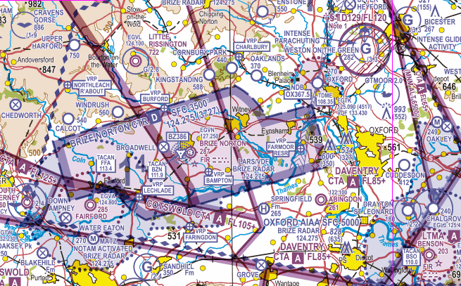
Figure 1 Brize Norton CTR
Most IFR aircraft are large military transport aircraft (A330, C17, A400M or C130). Given the confines of the airspace this means that the timing of turns is critical – especially when making allowance for the wind. Often the controllers are not only ensuring the traffic is kept inside controlled airspace but also sequencing them against aircraft radar training circuits and IFR procedures as well as visual arrrivals. This means a high degree of accuracy is required and considerable co-ordination between different control positions adding to controller workload and task complexity.
Transits through the Brize CTR
When transiting the CTR under IFR, the pilot will be placed under Radar Control on entering controlled airspace, at which point the controller becomes responsible for separation between IFR aircraft and terrain.
When transiting the CTR under VFR, the pilot will be placed under Radar Control on entering controlled airspace. Once under Radar Control with a VFR transit clearance, the pilot is responsible for separation between all aircraft and terrain. The Approach controller is the airspace manager at Brize Norton and will issue a transit clearance to either the controller who is providing the service to the aircraft or to the aircraft if it is on his/her frequency. Prior to issuing a clearance, the controller will consider possible conflictions as follows:
- Radar Training Circuit Traffic which is normally operating between 2,300 ft QNH and 2,800 ft QNH. On occasions the traffic may be above that altitude. These are normally flown to the south and east for Runway 25 and to the north and west for Runway 07.
- Visual Circuits which are flown between 1,300 ft QNH and 1,800 ft QNH.
- Arrivals via airways which route inbound via the reporting points NAXAT (283o/6.4nm from Brize Norton) or MALBY (246o/20nm from Brize Norton) descending from FL90. In Class G airspace, the traffic is normally under a Deconfliction Service.
- Departures joining controlled airspace which route outbound via NAXAT or MALBY climbing to FL80. Again, in Class G airspace the traffic is normally under a Deconfliction Service.
Pilots operating under VFR should be aware of the possibility of wake turbulence due to the size of the aircraft operating at Brize Norton.
Minimum Separation Standards for Aircraft within the CTR
The following separation standards are required between KNOWN traffic inside the CTR:
- IFR and IFR – 3nm or 1,000 ft (exceptionally, reduced vertical separation of 500 ft may be applied if the civil pilot accepts it and a re-route is impractical).
- VFR and IFR – 3nm or 500 ft. If the pilot operating VFR is visual with the IFR aircraft, he/she can take their own separation.
- VFR and VFR – Pilots operating VFR are responsible for their own separation from traffic based on traffic information issued by the controller.
An infringing aircraft that is not radar identified by Brize Radar becomes unknown traffic; a separation standard of 5nm laterally or 5,000 ft vertically is required between that aircraft and IFR aircraft inbound to, or outbound from, RAF Brize Norton operating within Brize Norton CTR.
Standard Transit Routes
Having called Brize Zone on 119.000 MHz, 10-15 nm prior to entry into controlled airspace, pilots can expect to be issued with one of the following VFR routes:
- 8 miles East of the aerodrome (via Farmoor reservoir VRP).
- 8 miles West of the aerodrome (Fairford to Northleach Roundabout VRP).
- At 3,300 ft QNH in any direction.
- At 2,300 ft QNH one nm through the Approach Lane (west or east of the aerodrome will be specified).
- Directly through the overhead not above 1,300 ft QNH.
- Any other routing subject to internal coordination with other control positions.
Adjacent Airspace/Aerodromes
RAF Fairford
To the southwest of the CTR lies RAF Fairford which is home to deployments of USAF aircraft and the location of the annual Royal International Air Tattoo. The aerodome lies within an Aerodrome Traffic Zone (ATZ) which is established under Rule 11 of Rules of the Air Regulations 2015. The ATZ is a circle of 2.5nm radius centred (at 514101N 0014725W) on the longest notified runway (Runway 09/27); it extends from the surface to 2,000 ft above aerodrome elevation (2,286 ft amsl). The ATZ comprises both Class G airspace and, where coincident with the Brize Norton CTR, Class D airspace. The ATZ is notified as active H24 in the UK AIP ENR 2.2. Under Rule 11, pilots require permission from the controlling authority (Brize Radar) to enter the ATZ at any time. On occasions, a Military Aerodrome Traffic Zone (MATZ) is also established which extends around and above the ATZ and is notified by NOTAM. The MATZ is a circle of 5nm radius (also centred at 514101N 0014725W) up to 3000ft above aerodrome elevation with a single stub to the east aligned with the approach to Runway 27. The stub extends 2nm either side of the final approach track from 5nm to 10nm and extends from 1,000 ft to 3,000 ft (both above aerodrome elevation). The MATZ airspace structure requires all military aircraft to obtain permission to enter; pilots of civil aircraft only require permission to enter the ATZ which lies within the MATZ; however, it is good airmanship for pilots of civil aircraft to call for a MATZ penetration when it is established.
Oxford Airport
To the northeast of the CTR lies Oxford Airport. The aerodome is protected by ATZ which is also established under Rule 11 of Rules of the Air Regulations 2015. The ATZ is a circle of 2nm radius centred at centred (at 515013N 0011912W) on the longest notified runway (Runway 01/19); it extends from the surface to 2,000 ft above aerodrome elevation (2,270 ft amsl). The ATZ comprises Class G airspace and is notified as active coincident with Tower hours (0630 – 2230 hours UTC (winter) (which is 0530-2130 hours UTC in summer)) except Christmas and New Year. Details can be found in the UK AIP EGTK AD2.17 and 2.18. Under Rule 11, pilots require a permission from the controlling authority (Oxford Approach) to enter the ATZ at any time.
Little Rissington
To the north (3.8nm from the edge of the CTR) lies the aerodrome at Little Rissington. This is home to 637 VGS a military gliding unit which carries out winch launching of gliders. The aerodrome lies 722 ft amsl and winch cables may be enountered up to 2,000 ft above aerodrome elevation (2,800 ft amsl). Gliders, however, may be encountered at higher altitudes overhead and in the vicinity of the aerodrome. Activity times are notified in the UK AIP ENR 5.5 in the section with other military units.
Important factors to think about when flying in the vicinity of RAF Brize Norton
Always use a moving map
There are many reasons why a pilot can lose situational awareness of his/her position that could result in an airspace infringement. Whether flying recreationally or carrying out an instructional flight, the correct use of a moving map is known to reduce that risk and assist in increasing pilot capacity.
Take 2
An initiative through the Local Airspace Infringement Teams (LAIT) is to Take 2. By remaining, when able, at least 2nm horizontally away from the edge of the CTR or in the case of the CTR, 200 ft above. Any inadvertent deviation from level flight or planned course could be caught in sufficient time to prevent an airspace infringement.
Use the appropriate Frequency Monitoring Code (FMC) and listen out
The airspace outside the CTR is Class G airspace and there is no requirement to receive a service from Brize or Oxford Radar (unless you require entry into the ATZs notified above). However, the introduction of the FMC’s below allow ATC to observe an aircraft that may have potential to conflict with their traffic and transmit a blind call asking them to establish comms.
- 3727 for Brize Norton on frequency 124.275 MHz; or
- 4517 for Oxford on frequency 125.090 MHz
Once communication is established, and the aircraft is identified, the potentially conflicting aircraft becomes known traffic to the controller, enabling tactical planning or incident recovery to be completed quickly. Use of this FMC has been proven to prevent infringements and reduce the severity of such occurrences, as well as enhance the controller’s and pilot’s situational awareness, creating a safer and more predictable situation than would otherwise exist.
If appropriate – request a clearance.
If for any reason entry into the Brize Norton CTR is required, then a clearance must be obtained. Depending on a variety of factors, not least the runway in use and traffic situation at the time, this will be available. By obtaining a clearance to enter controlled airspace ATC can control you more effectively and ensure safety is maintained.
More hot-spot narratives can be found on this page: Local area information
Preventing airspace infringements in the vicinity of the Pennines to the east of Manchester
UPDATED 20 February 2025
This infringement update has been written by members of the Northwest LAIT at Manchester Airport Air Traffic Service Unit.
The Class D Manchester CTR extends from the Surface to 3,500 feet AMSL; the Manchester CTA 3 is also Class D with a base of 3,000 feet AMSL and an upper limit of 3,500 feet AMSL. Above both is the Manchester Control Area (TMA) which is Class A airspace. All airspace is based on the Manchester QNH.
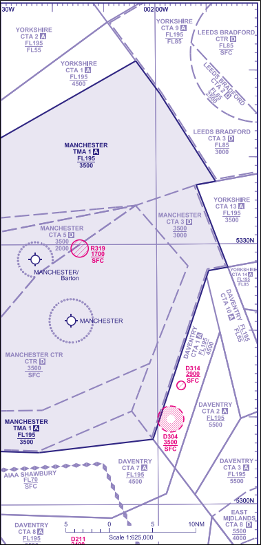
Land features and VRPs
The following land features are all outside Manchester CTR and under CTA 3:
- the VRP at Dovestone Reservoir;
- Chew Reservoir;
- the easterly lakes of Torside Reservoir;
- Kinder Reservoir;
- Combs Reservoir;
- Fernlee Reservoir; and
- Errwood Reservoir.
The VRPs at Glossop, Whaley Bridge and Lamaload Reservoir all lie on the edge or inside the Manchester CTR.
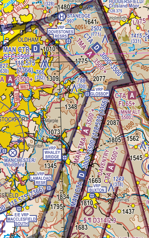
VRPS on the edge of the Manchester CTR
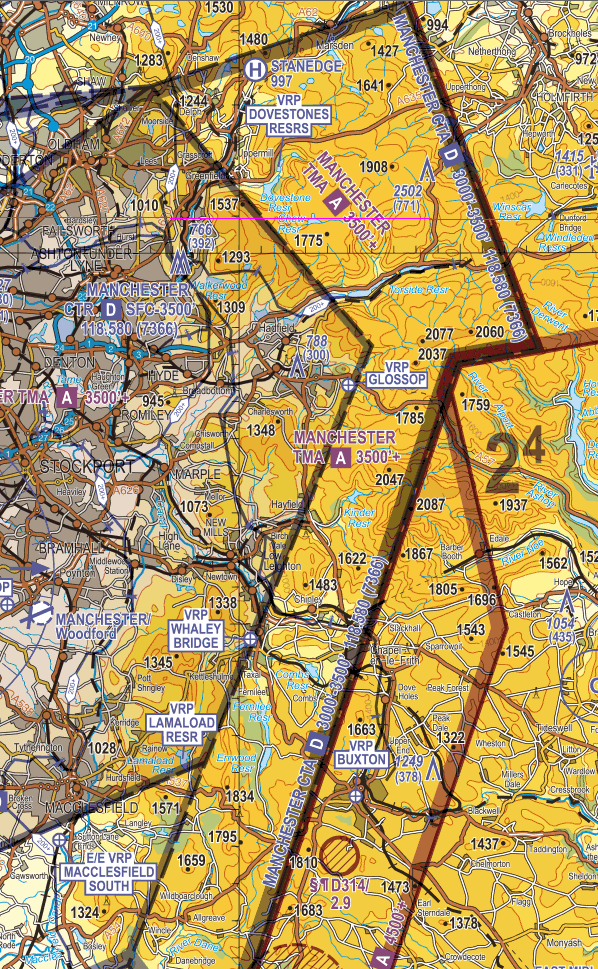
VRPS on the edge of the Manchester CTR
Known hot-spot
A known infringement hotspot is on the west side of the Pennines between Stanedge (a helicopter site marked on the VFR chart) and Whalley Bridge, with the most infringed area around Dovestones Reservoir.
Causal factors
The main causal factors associated with airspace infringements in this area are:
- flying too close to the Manchester CTR to remain to the west of the Pennines;
- flying too close to the base of the Manchester CTA or operating on the RPS and not the Manchester QNH. Since the RPS being the lowest forecast pressure for the entire Barnsley Altimeter Setting Region, when flying on the RPS, pilots will be higher in relation to controlled airspace than they think. Remember: “Wind-on Hectopascals, wind-on height”; and
- operating on the London Flight Information Service frequency rather than Manchester Radar’s frequency. This offers no ability for prompt resolution to a potential airspace infringement. When pilots listen out on Manchester Radar (and squawking 7366), Air Traffic Control has got the opportunity to carry out ‘defensive controlling’ and free-call an aircraft prior to the pilot possibly infringing. In addition, pilots will hear the Manchester QNH being given to IFR inbounds thereby obtaining the correct altimeter setting.
To prevent an airspace infringement
As part of their pre-flight planning and in-flight execution, pilots are strongly encouraged to:
Use a Moving Map and, when able, Take 2.
Use the Manchester FMC. When flying close to controlled airspace, rather than squawking 7000 or obtaining a Basic Service from London Information (which is a non-surveillance unit), use the Frequency Monitoring Code by squawking 7366 and monitoring Manchester Radar on 118.580 MHz. If the aircraft is fitted with Mode S transponder, the Manchester Radar controller will be able to see your callsign on their radar display and will be able to call you if they observe anything untoward. Aircraft should not hesitate to establish contact with Manchester Radar if they require any assistance or are unsure of their position.
Plan. As part of your plan, consider not only the route but forecast and actual weather conditions on the Pennines. This should be done with reference to the regulated meteorological information available on the UK Met Office Aviation Briefing service. This free service includes, but is not limited to, he following regulated information:
- TAFs and METARS;
- Regional Forecasts including GAMETs;
- MetForms 214 and 215;
- Radar and satellite images; and
- Forecast precipitation, pressure, winds and temperature.
Avoid flying on the Regional Pressure Setting (RPS) in the vicinity of Manchester Controlled Airspace. When flying on the RPS, as it is the forecast lowest QNH for a region, you will probably be higher in relation to the Manchester QNH. If you are receiving a FIS from London Flight Information Service, ask the FISO for the relevant QNH rather than remaining on the Barnsley RPS.
Obtain an air traffic service. Know which ATS unit can provide a LARS. To the south of the Manchester controlled airspace it is Shawbury Zone (133.155MHz) and East Midlands Radar (134.180 MHz); to the north it is Warton Radar (129.530 MHz). It is also important to know the relevant operating times and frequency Designated Operational Coverage (DOC) and LARS radius for each ATS unit so that a detailed communications plan can be formulated pre-flight:
- Shawbury Zone – LARS radius – 40NM
- East Midlands Radar – Frequency DOC 60NM/ LARS radius 30NM
- Warton Radar – Frequency DOC 40NM/LARS radius 40NM
Availability of service times can be found in the UK AIP at ENR 1.6 table 4.1.6 and relevant NOTAM.
Preventing airspace infringements in Liverpool Controlled Airspace through defensive controlling and the use of Frequency Monitoring Codes
UPDATED 20 February 2025
This infringement update has been written by members of the Northwest LAIT at Air Traffic Control Services Limited (ATCSL) at Liverpool Airport.
Liverpool has historically had its fair share of airspace infringements. Its geographical location on the coast means that to the west it sometimes has pilots ‘hugging the coast’ and infringing the Control Area (CTA) as the base is 2,000 feet AMSL. More often though, the infringements are due to pilots cutting the corners of the northern and southern ends of the North West Transit Corridor and therefore infringing the Northeast and Southeast corners of the Liverpool Control Zone (CTR).
Much work has been done in recent years to try to reduce these infringements, by controllers and pilots coming together at the North West LAIT, discussing the hot spots for infringements (as described above) and providing much-needed focus on the topic. The North West LAIT is well attended by many local flying clubs and schools, whose flying instructors, student pilots and PPL holders are genuinely keen to play their part in keeping the number of infringements of the local airspace to a minimum.
As a result, infringements have indeed reduced. In 2017 there were 34 infringements of Liverpool’s controlled airspace and in 2018 the number fell to 18. For 2019, the figure reduced further to 9. This has largely been attributed to defensive controlling by the Liverpool controllers and the use of Frequency Monitoring Codes (also known as ‘Listening Squawks’) by pilots.
The Liverpool Air Traffic Services Manager, Matt Jackson, explains how defensive controlling works and the benefits of frequency monitoring codes.
“When there are 7000 squawks within a few miles of the edge of controlled airspace, you generally keep an eye on them to see what they’re doing, as much as possible. Sometimes if it’s really busy and you are working lots of traffic you will not be able to give the 7000s much attention, but you will be aware that they are there.
If an aircraft looks as though it is heading towards my airspace I would try calling it to see if it is on my frequency. This is known as defensive controlling, i.e. defending the boundary of your airspace and pro-actively asking pilots heading towards the boundary what their intentions are, before they reach it. This means that a controller will pre-empt a pilot infringing their airspace by contacting the pilot and effectively saying ‘you seem to be heading towards my airspace – would you like a clearance to enter it?’
This is where the Frequency Monitoring Codes, FMCs, are so incredibly useful and I would really encourage all pilots to please use FMCs whenever they possibly can. It definitely helps in these situations.
If the aircraft does not respond to my call and is obviously not on my frequency, this can make things quite difficult. It may enter my airspace, in which case I may need to tactically manage the other traffic in the area, to ensure I avoid it. This may even go to the extent of offering inbound aircraft the off-duty runway, just to avoid the unidentified traffic – which is not an ideal situation.
I may need to speak to neighbouring ATS units to ask whether they know the aircraft’s callsign or whether it is on their frequency, just to try and establish contact with it.
However, if an aircraft is squawking the Liverpool frequency monitoring code 5060 and listening out on my frequency (Liverpool Radar 119.855 MHz), all of this inconvenience and extra hassle goes away! It shows that the pilot has done their homework and has good situational awareness – which is a great start! If I need to call them, they should be listening out on my frequency, ready to respond. I can literally ask them what their plan is.
If they were about to call to ask for a zone entry, I can try to provide them with what they want. If they are just operating near the edge of controlled airspace and don’t want to enter, at least we can have a chat so I can find out what their plan is.
As an example, a scenario that we are faced with frequently is where light aircraft fly between Blackpool and Caernarfon, following the coastline at 2,500 feet. These aircraft will sometimes call Liverpool Radar to ask for a clearance through the CTA at 2,500 feet QNH, which we will try to accommodate if we possibly can. Many aircraft following this route, however, do not call and just blast straight through the airspace!
As it is a known traffic route – especially on a sunny day – Liverpool controllers will be suspicious of any traffic which appears to be following this route but not talking to them. This is where being able to call the aircraft on 119.855 MHz to ask what the pilot’s intentions are is invaluable, offering a clearance through the airspace if that is what the pilot wants.
Defensive controlling if a great way to help pilots avoid airspace infringements, but it will only work if pilots are listening on the right frequency!
It is very different to the opposite – perhaps outdated – way of thinking, which is for a controller to watch a pilot flying towards their controlled airspace and not to say anything, to watch the pilot infringe their airspace, and then tell them they have infringed. This doesn’t really help anyone because it could have been avoided.
Yes, it is always the pilot’s responsibility to not infringe, but if the controller can predict it is about to happen, surely it is better for everyone if the situation is avoided. Please use frequency monitoring codes to help controllers help you not infringe!”
AIC Y111/2022, found on the NATS AIS website, refers to the use of FMC in the UK FIRs. Paragraph 2 explains the methodology of their use. Whilst Liverpool ATSU applies ‘defensive controlling’ exceptionally well, not all ATSUs have the capacity to apply this controlling methodology. However, subject to workload, ATC will often endeavour to provide a timely warning if an aircraft looks like it will infringe but there can be no guarantee that pilots will always be warned if controlling capacity does not permit. Pilots remain responsible for their own navigation and in particular for obtaining permission to enter controlled airspace.
To prevent an airspace infringement, as part of their pre-flight planning and in-flight execution, pilots are strongly encouraged to:
Use a Moving Map and, when able, Take 2.
Plan. As part of your plan, consider not only the route but also the relationship between prominent geographical features and the limits of controlled airspace. As an example, in following the coast from Hoylake to Flint Bridge at 1,800 feet Liverpool QNH (to remain under CTA-4) there are places where being over water the pilot may also be inside the Liverpool CTR or CTA-2.
Avoid flying on the Regional Pressure Setting (RPS) in the vicinity of Liverpool Controlled Airspace. When flying on the RPS, as it is the forecast lowest QNH for a region, you will probably be higher in relation to the Liverpool QNH. If you are receiving a FIS from London Flight Information Service, ask the FISO for the relevant QNH rather than remaining on the Barnsley or Holyhead RPS.
Obtain an air traffic service. Know which ATS unit can provide a LARS. To the south of the Liverpool controlled airspace it is Shawbury Zone (133.155MHz) and to the north it is Warton Radar (129.530 MHz).
Maintain not above 1,500 feet (Manchester or Liverpool QNH) in EG R323 (North West Transit Corridor)). Liverpool cannot vector aircraft east of the eastern edge of EG R323 and, therefore, when required to sequence their inbound traffic one method available is to vector traffic towards the northeast of the Liverpool CTR which sits above the northern portion of the CTR. The Liverpool traffic must be at 2,000 feet to safely pass beneath the Manchester departures whilst aircraft within the North West Transit Corridor can be at 1,500 feet and just 500 feet below.
Therefore, any aircraft initiating an early climb above 1,500 feet before they have left the northern edge of the North West Transit Corridor pose a serious risk to the Liverpool traffic; in addition, there is an increased risk of experiencing wake turbulence issues. When the Liverpool radar controller observes aircraft climbing early and infringing above the northern portion of the North West Transit Corridor, they are unable to take avoiding action by climbing as this will result in confliction with the Manchester departures, instead the only option available is to make an avoiding action turn. With the resultant delay in flight crew initiation compounded by the rate of turns, the potential for a loss of separation event is increased.
The author Mr Matt Jackson, Liverpool Air Traffic Services Manager
Infringements of Aerodrome Traffic Zones (ATZ)
This update is the fourteenth in a series of narratives focusing on identified infringement hot-spots in the UK. It focuses on infringements of Aerodrome Traffic Zones (ATZ) and sets out the requirements to comply with Rule 11.
Introduction
An airspace infringement is the unauthorised entry of an aircraft into notified airspace and there is a requirement to report them. Notified airspace includes permanent and temporary controlled (CAT/TMA and CTR), prohibited and restricted airspace, permanent and temporary active danger areas, radio and transponder mandatory zones (RMZ and TMZ) and Aerodrome Traffic Zones (ATZ).
In 2019 there were 100 reported ATZ infringements across 45 ATZs. Reported figures are regularly published here: airspacesafety.com/facts-stats-and-incidents/
ATZs and Rule 11
- ATZs are established to protect traffic around an aerodrome.
- ATZ is defined in Article 5 of the Air Navigation Order 2016.
- ATZ are marked on a chart as a circle of magenta dots with the aerodrome name and elevation (in feet amsl).
- Aerodromes that are notified in the AIP are ‘protected’ by Rule 11
ATZ dimensions
ATZs normally extend from land surface to 2,000 feet agl. The radius depends on the length of the aerodrome runway, either 2.5 NM or 2 NM from the midpoint of the longest runway. Offshore the dimensions are from sea level to 2,000 above mean sea level, with a radius of 1.5 nm. Some ATZ have non-standard dimensions. See Aerodrome Traffic Zones and UK AIP for more details.
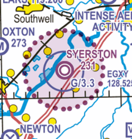
ATZ marked on a chart
The applicability of Rule 11 depends on the type of aerodrome.
For Government aerodromes Rule 11 applies at the times notified in the UK AIP (ENR 2.2) or when notified by NOTAM.
Example listing from UK AIP ENR 2.2
For an aerodrome that has an air traffic control unit or flight information service centre Rule 11 applies during the notified hours of watch of the air traffic control unit or the flight information service centre
For a national licensed aerodrome or an EASA certificated aerodrome having an air/ground communications service unit with aircraft Rule 11 applies during the notified hours of watch of the air/ground communications (AGCS) service unit.
Example listing from UK AIP EGBE AD 2.17
What about MATZ?
A Military Aerodrome Traffic Zone (MATZ) provides a volume of airspace within which increased protection may be given to aircraft in the critical stages of circuit, approach and climb-out; a MATZ also contains an ATZ.
A MATZ has a circle of 5 NM radius up to 3,000 ft aal and with additional ‘stubs’ aligned with selected approach path provides a volume of airspace within which increased protection may be given to aircraft in the critical stages of circuit, approach and climb-out.
All military aircraft have to obtain permission to enter the MATZ . It is good airmanship for civil pilots to call for a MATZ penetration. And they have to comply with Rule 11 in respect of the ATZ that that lies within the MATZ.
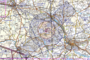
ATZ within a MATZ on a chart
Pilots intending to overfly Government aerodromes protected by an ATZ should be aware of some activities that extend above the vertical extent of the ATZ such as:
- Aircraft conducting PFLs from above, but into, the ATZ. Aircraft such as the Tutor will climb to between 3,000 and 2, 500 feet aal to position to High Key to commence the PLF procedure.
- Glider operations. Not only do some winch launch operations extend to above the ATZ eg 3,300 feet amsl at Syerston but intense gliding activity may be present in the airspace above the ATZ.
What is an Infringement of an ATZ?
An ATZ, and compliance with Rule 11, provides a safety barrier against mid-air collisions by enabling increased situation awareness to pilots operating in the aerodrome traffic pattern. This is essential in airspace where many of the other barriers such as air traffic control and radar supported by infringement warning tools (such as CAIT – Controlled Airspace Infringement Tool) are absent. Some 2/3 of Class G ATZ are not serviced by radar.
Rule 11 refers to Rule 11 of Rules of the Air 2015. Paragraphs 3, 4 and 5 set out conditions that must be met before an aircraft can fly, take-off or land within the ATZ. Failure to comply with one of these 3 paragraphs prior to entering the ATZ will mean that the pilot has infringed the airspace.
A pilot’s responsibility prior to entering an ATZ depends on the type of service provision. An aircraft must not fly, take off or land within the ATZ unless the commander of the aircraft has complied with paragraphs (3), (4) or (5) of Rule 11, as appropriate as follows:
- If the aerodrome has an air traffic control unit the commander must obtain the permission of that unit to enable the flight to be conducted safely within the ATZ. (Rule 11, para 3)
- If the aerodrome provides a flight information service the commander must obtain information from the flight information centre to enable the flight to be conducted safely within the ATZ (Rule 11, para 4).
- If there is no flight information centre at the aerodrome the commander must obtain information from the air/ground communication service (AGCS) unit to enable the flight to be conducted safely within the ATZ (Rule 11, para 4).
To comply with point 1 above, the pilot simply needs to obtain a permission from ATC to enter the ATZ.
To comply with points 2 or 2 above, the pilot must achieve 2-way communication with the AFISO or AGCS. Listening to AFISO or ACCS transmissions to and regarding other aircraft does not satisfy the requirement to obtain information from the AFISO or AGCS to “enable the flight to be conducted safely”. The location, altitude, speed, etc. of other aircraft within/into/out of the ATZ will be different to the flight in question. The pilot will not be informed about the airspace/air traffic environment, such as non-radio aircraft that have previously coordinated their arrival, by listening to information related to other aircraft and neither intended for nor necessarily relevant to his/her flight. Equally, the AFISO and other traffic within and around the ATZ will be unaware of ‘listening only’ aircraft and this reduces the wider situational awareness of aerodrome traffic.
The Rest of Rule 11
There is one more paragraph of Rule 11, (paragraph 6) and requires a pilot to:
- maintain a continuous watch on the appropriate radio frequency notified for communications at the aerodrome; or
- cause a watch to be kept for such instructions as may be issued by visual means if that is not possible; and
- if the aircraft is fitted with a radio communicate the aircraft’s position and height to the ATC unit, flight information centre or the ACGS unit (whichever is relevant) on entering the ATZ and immediately prior to leaving it.
If the pilot has complied with Rule 11 paragraphs 3, 4, or 5 but has not complied with point 3 above (Rule 11 para 6c), the pilot has not infringed the ATZ but has breached Rule 11 and has demonstrated poor airmanship.
In Summary
A pilot who has only obtained information by listening out rather than having obtained information by 2-way communications, and has not reported entering the ATZ, has committed an airspace infringement.
A pilot who has complied with the Rule 11 (2) – (5) but has not reported entering the ATZ iaw Rule 11 (6)(c) has not infringed the ATZ but has demonstrated poor airmanship and not has not fully complied with the requirements of Rule 11.
What next?
The next step is to double check that you understand rules around an ATZ and know how to comply with Rule 11.
A comprehensive briefing for Pilots, ANSP and AGCS units has been shared by the CAA and is available here: ATZ Brief.
Redhill – Preventing Airspace Infringements in the vicinity of Gatwick
Effect of infringements on Terminal Control and Gatwick Approach
A controller is required to provide a minimum separation of 3NM laterally or 3,000 feet vertically between IFR aircraft and any unknown aircraft within the Control Area (CTA) / Control Zone (CTR). An infringement of Gatwick controlled airspace may have an immediate impact on the controller’s workload and may require the controller to issue avoiding action or a suspension of Gatwick movements. In some cases, an immediate Loss of Separation may occur between the unknown aircraft and any aircraft inside controlled airspace. A suspension of arrivals will result in arrivals holding with an immediate impact on Approach and Terminal Control Area (TMA) controller workload, pilot workload and result in delays and disruption to the airport operation.
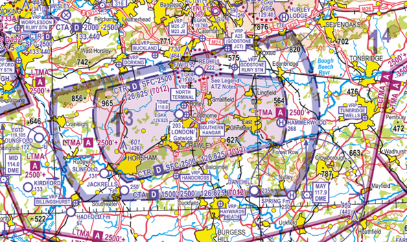
Figure 1: CAA 1:500,000 South – Edition. 51 (double click to open the image in a new tab)
Gatwick Controlled Airspace
The Gatwick CTR extends from the Surface to 2,500 feet AMSL with the CTA extending from 1,500 feet to 2,500 feet AMSL; both are Class D airspace. The Class A London Terminal Control Area (LTMA-1) extends upwards from 2,500 feet AMSL to FL195. To assist VFR pilots, the airspace is aligned with many easily identifiable ground features, including:
-
- the M25 follows the northern boundary of the CTA, to the east of Redhill
-
- the A25 just outside the northern edge of the CTA west of Redhill
-
- the Redhill to Tonbridge railway line just to the north of the CTR
-
- Bough Beech reservoir on the eastern boundary of the CTA
- Leith Hill just inside the north-western corner of the Gatwick CTR.
Redhill Aerodrome
Redhill Aerodrome is situated approximately 4.5NM northeast of Gatwick Airport. The Aerodrome Traffic Zone (ATZ) is a non-standard shape due to the southern half of the aerodrome laying within the Gatwick CTR, whilst the northern half lays beneath the Gatwick CTA (Figure 2).
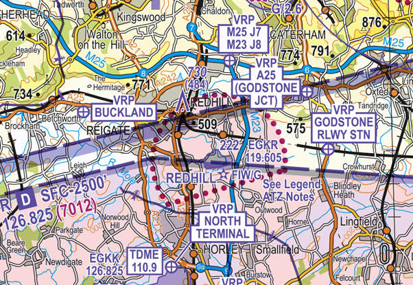
Figure 2: NATS/CAA 1:250,000 England South – Edition. 28 (double click to open the image in a new tab)
Redhill Local Flying Area (LFA)
The LFA is not coincident with the ATZ and comprises 2 parts, A and B (Figure 3). The maximum altitude within both LFAs is 1,400 feet on the Redhill QNH unless otherwise coordinated with Gatwick ATC. All aircraft joining or leaving the Redhill LFA must do so at a point north of the Gatwick CTR.
The western fillet of the LFA permits aircraft to enter and leave the ATZ via Buckland VRP without entering the Gatwick CTR.
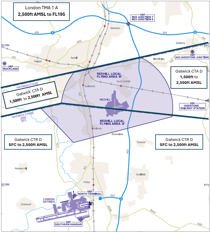
Figure 3: Local Flying Area AD 2.EGKR-4-1 (double click to open the image in a new tab)
An Air Traffic Control (ATC) service is provided by Redhill Tower on channel 119.605 MHz and has a Designated Operational Coverage (DOC) of 25NM and 4,000 feet. An ATIS is available, H24, on channel 125.305 MHz.
Redhill uses a conspicuity code of 3767 which pilots must only select when instructed to do so by Redhill Tower.
Within the ATZ, the maximum operating altitude is 1,400 feet Redhill QNH with circuits flown at 1,200 feet QNH; opposite direction circuits are flown during fixed-wing and helicopter operations. Due to the size of the LFA there is no deadside and pilots are therefore required to fly the non-standard overhead join as documented in the AIP (EGKR AD 2.22.2.a.i.1).
There is no requirement to contact Gatwick ATC for permission to enter the Redhill LFA provided flights are made within the published LFA and the pilot has obtained the appropriate permission from Redhill ATC prior to entering the LFA.
Pilots joining from overhead Gatwick Airport should plan to route via Buckland VRP unless co-ordination has taken place between Gatwick and Redhill ATC.
The Redhill UK AIP entry also contains other operational information and details of the LFA.
Visual Reference Points (VRPs)
Redhill Aerodrome has the following four published VRPs (Figures 2 & 3):
-
- A25 Godstone Junction (commonly referred to as ‘Godstone’)
-
- Buckland
-
- Godstone Railway Station
- M25 Junction 7/M23 Junction 8 (commonly referred to as ‘The Junction’)
In addition, pilots may occasionally be requested to route via the north of Reigate.
Redhill Tower requires all VFR/SVFR aircraft to enter and leave the ATZ via standard VFR routes that utilise the published VRPs.
Threats within the Redhill circuit
Pilots are to obtain the latest information from Redhill UK AIP. Specific information on circuit diagrams can be obtained from Redhill website.
Redhill operates simultaneous helicopter and fixed-wing operations using opposite direction circuit patterns to provide separation between aircraft types. All procedures are based on Redhill QNH, ATC will provide QFE only when requested by pilots. The use of QFE is strongly discouraged to avoid pilots infringing the Gatwick CTA.
Runway 07/25
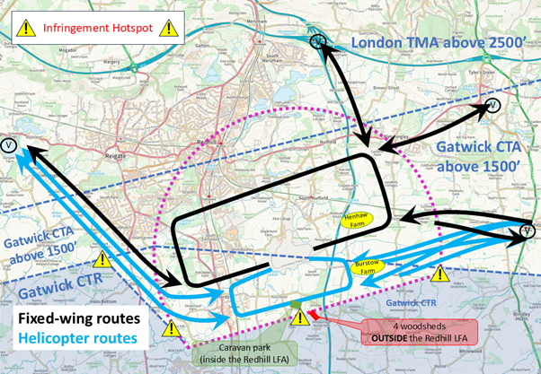
Figure 4: Runway 07/25 (double click to open the image in a new tab)
Runway 07R/25L is the preferred runway. When Runway 07/25 is in use, helicopter pilots on the downwind leg must ensure that they remain north of the southern ATZ boundary, approximately mid-way between Axes Lane and Cross Oak Lane. This is particularly important at night when fewer ground features are visible.
When Runway 07 is in use fixed-wing pilots must not extend their circuit beyond Benting Wood to avoid entering the Gatwick CTR.
Runway 18/36
Figure 5: Runway 18/36 (double click to open the image in a new tab)
Aircraft using this runway must have a serviceable transponder. Runway 18/36 presents a greater risk of affecting Gatwick operations thus pilots must exercise extra caution to avoid infringing.
When Runway 18 is in use, the ATIS will include a reminder to pilots that they must commence their crosswind turn on crossing taxiways C and D.
Pilots must ensure they track parallel to the Runway 07 on the crosswind leg to avoid exiting the LFA and thus infringing the Gatwick CTR.
For fixed-wing aircraft flying the standard (left-hand) circuit pattern, this is a turn of more than 90° which must be made at low level. This is especially important to consider when commencing the take-off run from the displaced threshold on Runway 18 at Hold G3; if in any doubt, always request full length from ATC to provide an additional margin.
When Runway 36 is in use the ATIS will include a reminder to pilots that they must turn base leg at Burstow Park Farm and turn final within 0.5nm of the threshold.
The base leg must track parallel to the Runway 25. Allow for the drift caused by the northerly wind. Report final on crossing the M23 motorway.
For all operations to the south, four large green woodsheds are located just outside the southern boundary of the LFA which provide a good visual landmark (Figure 6); these must be kept to the south of the aircraft at all times. A caravan park just north of these woodsheds and thus inside the LFA provides an excellent additional reference feature to maintain situational awareness.
Local Area Navigation Threats
Railway Line
A common navigational feature used by pilots when routing inbound to or outbound from Redhill aerodrome is the railway line (Redhill / Tonbridge) extending from Redhill ATZ to the east (Figure 4). The railway line sits below Gatwick CTA and is approximately 0.5NM north of the boundary of Gatwick CTR. When using this feature to navigate, it is important not to become distracted when changing frequencies or performing checks to prevent you inadvertently climbing or turning into controlled airspace.
It is strongly recommended to keep the railway line feature on the left of the aircraft at all times for deconfliction with aircraft operating from Redhill flying in the opposite direction.
Bough Beech Reservoir
Bough Beech reservoir is a prominent VFR navigation feature often used by pilots when inbound to or outbound from Redhill. The reservoir is located on the boundary of Gatwick CTA; it is therefore important that you are below 1,500 feet AMSL (the base of Gatwick CTA) prior to reaching the reservoir when routeing westbound and eastbound. The curved Gatwick CTA to the east bisects Bough Beech Reservoir; pilots must be especially cautious when routing south and using the reservoir as a navigational feature since the CTA south of the reservoir extends considerably to the east.
Figure 6: Bough Beech reservoir (double click to open the image in a new tab)
M25 Motorway
Another prominent navigational feature used by pilots is the M25 motorway. It is important to note that the M25 passes less than 1NM south of the Biggin Hill Aerodrome Traffic Zone and is also surrounded by high terrain. If operating to the south of the M25 it is important to ensure that you monitor your altitude in relation to the Gatwick CTA. The CAA recommends (where able) to ‘Take 2’, however this may not be possible in areas of high terrain and you may be unable to remain 200 feet below the base of Gatwick CTA. In this case, it is important you remain especially aware of your altitude to prevent an inadvertent climb into controlled airspace.
Preventing an Airspace Infringement
To prevent an airspace infringement, as part of their pre-flight planning and in-flight execution, pilots are strongly encouraged to:
Read the Redhill Operational Procedures documents. These are freely available on the airfield website (www.redhillaerodrome.com/operational-information). This page links to documents which contain details of the LFA, VRPs, as well as detailed information relating to arrival/departure tracks, circuit and noise abatement procedures.
Make a detailed plan. Identify climb and descent points along your route and incorporate ‘Take 2’ wherever possible and mark these points on your chart and VFR Moving Map device as waypoints and incorporate them into your PLOG. Know which VRPs are relevant to your flight and what they look like from the air.
Use a VFR Moving Map in conjunction with a regulated chart to allow you to cross-check your position in-flight. Enable airspace warnings to help identify airspace when in close proximity. It is also good practice during the planning phase to make use of the Simulation Mode in the application if one exists; this can, in the benign ground environment, highlight notified airspace along your planned route and ensure alerts to airspace appear as expected and according to the user configuration of the planning/navigation options. Moving Map technology should not be the sole means of planning or navigation as highlighted in the European General Aviation Safety Team’s Safety Promotion Leaflet and the UK CAA Safety Sense leaflet.
Use the Gatwick Frequency Monitoring Code (FMC). Pilots operating outside controlled airspace, the Biggin Hill and Redhill ATZs but proximate to Gatwick controlled airspace and not making using of Farnborough Lower Airspace Radar Service (LARS) are encouraged to make use of Gatwick Frequency Monitoring Code (7012) by monitoring Gatwick Director on 126.825 MHz.
Ensure you are operating on the correct QNH by listening to the Redhill ATIS on channel 125.305 MHz. If you are unable to receive the Redhill ATIS, use the Gatwick QNH from its ATIS frequency of 136.525 MHz.
Wherever possible, ‘Take 2’ and remain 200 feet below or 2NM from the boundary of Gatwick’s controlled airspace. In areas of high terrain when below Gatwick CTA, ensure to monitor your altitude to prevent inadvertent climbs into controlled airspace.
If appropriate – request a clearance. If for any reason a climb is required above the base of the CTA, then a clearance must be obtained from Gatwick Director on 126.825 MHz. If in any doubt, contact Gatwick Director for assistance.
Impact of forecast weather on your flight. Thermic or turbulent conditions can inadvertently push you upwards. Use the regulated Met Office Aviation Briefing Service in your planning. In addition, refer to Farnborough and Heathrow METARs/TAFs to better visualise local conditions and how they might affect your flight.
Apply Threat and Error Management when planning and flying. Always consider airspace when making a detailed plan. Build in climb and descent points when routing in the vicinity of multiple CTAs with differing base altitudes. Know what VRPs look like and what airspace lies above them or close by. One of the biggest causes of infringements is distraction; manage that Threat when operating close to controlled airspace.
Preventing airspace infringements in the vicinity of Stansted
This infringement update is the sixteenth in a series of narratives focusing on identified infringement ‘hot-spots’ in the UK. It has been written by members of the Stansted Local Airspace Infringement Team. This narrative has been updated August 2023.
In 2022, there were a total of 110 infringements of the 3 notified airspace types at Stansted: 44 were in the Control Areas (CTA), 23 were in the Control Zone (CTR) and 43 were in the TMZs. Infringement hot-spots have been identified as TMZ-2 and CTA-2.
In early 2009, the CAA approved the establishment of two Transponder Mandatory Zones (TMZ) around Stansted Airport resulting from overriding safety concerns in relation to the number, and severity, of airspace infringement risk of the two CTAs adjacent to the CTR reported in previous years. The introduction of the TMZs in September 2009 negated any additional controlled airspace to be introduced but enhanced controller situational awareness and safety.
Over ten years later despite many pilots correctly adhering to the requirements, reports of infringements of the TMZ and Stansted controlled airspace continue to be submitted. Why are there still, on average, two infringements of Stansted notified airspace per week?
Transponder Mandatory Zones
TMZs 1 & 2 are co-incident with the lateral boundaries of CTA-1 (north-east) and CTA-2 (south-west) of the Stansted CTR. They are Class G airspace from the surface to 1,500 feet AMSL and are subject to UK SERA.6005 and therefore are notified airspace in relation to airspace infringements.
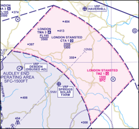
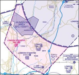
Access to the Stansted TMZs, without ATC approval, requires a serviceable Mode S Elementary transponder to be operated at all times and to its full extent. Within the TMZs, pilots are recommended to obtain a service from Farnborough LARS North (132.800 MHz) or maintain a listening watch on Stansted Radar (120.625 MHz) and make use of the Frequency Monitoring Code (FMC) of 7013.
The Air Navigation Service Provider (ANSP) facilitates access into the TMZ for those pilots whose aircraft do not meet the transponder requirement. The UK AIP publishes the requirements to operate within the TMZ in GEN1.5 (AIRCRAFT INSTRUMENTS, EQUIPMENT AND FLIGHT DOCUMENTS) paragraph 5.3.1(f); these requirements are reproduced in the various commercial flight guides.
If you wish to operate in a Stansted TMZ without a serviceable Mode S transponder or without any form of transponder, access may still be granted subject to specific ATC approval from either:
- Farnborough Radar on 132.800 MHz between 0800 hours and 2000 hours UTC; or
- Stansted Radar on 120.625 MHz at other times.
The procedures for Farnborough Radar to co-ordinate with Stansted Radar may result in short delay so an awareness of this fact in the pre-flight planning stage should be remembered and incorporated into your Threat and Error Management (TEM). Make a call with sufficient time to allow for a delay in receiving a clearance.
TMZ Infringements
When an unknown aircraft is detected within a TMZ there is a significant workload increase for the controller including a set procedure to be followed with co-ordination. Although Class G airspace, all un-identified primary only or Mode A-only returns will be treated as an airspace infringement; air traffic controllers must maintain separation of 3NM laterally or 3,000 feet vertically (when the altitude is indicated) between the infringing aircraft and any aircraft to which they are providing a service. If necessary ‘Avoiding Action’ may be passed to arriving and departing aircraft if already airborne or departing aircraft may be held on the ground and delayed depending upon the position of the unknown aircraft. A ‘Loss of Separation’ is recorded when it’s not possible to maintain 3NM laterally or 3,000 feet vertically from the unknown aircraft.
If you intend to visit any of the airfields near the TMZs, it is a good idea to review the arrival and departure procedures online and in VFR flight guides; you may be required to obtain a specific briefing from the airfield operators to ensure compliance of the agreed local ATC procedures. When you PPR/book into the aerodrome, ask the ANSP staff of any specific procedures that need to be followed.
Further information relating to the Stansted TMZ can be found in UK AIP EGSS AD2.2.7
Stansted Controlled Airspace
Although many pilots comply with the TMZ procedures, there are still reported infringements of CTA-1 and CTA-2 when pilots have climbed from the TMZ into the CTAs or flown through the corner of the CTR boundary.
The controlled airspace complex comprises the CTR and 4 CTA, levels depicted below. All airspace is Class D. The Class A London Control Area (LTMA) is contiguous from the upper CTA levels to FL195.
| Structure | Airspace Class | Level (AMSL) | Aerodromes Within/Below |
| Stansted Control Zone (CTR) | D | Surface – 3,500 feet | Hunsdon |
| Stansted CTA-1 | D | 1,500 feet – 3,500 feet | North Weald |
| Stansted CTA-2 | D | 1,500 feet – 2,500 feet | |
| Stansted CTA-3 | D | 2,500 feet – 3,500 feet | Andrewsfield, High Easter |
| Stansted CTA-4 | D | 2,500 feet – 3,500 feet | Audley End, Nuthampstead |
| LTMA-1 | A | 2,500 feet – FL195 | |
| LTMA-3 | A | 3,500 feet – FL195 |
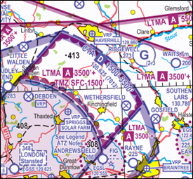
CTA-1 and TMZ-1 northeast of the Stansted CTR
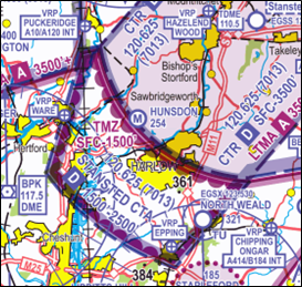
CTA-2 and TMZ-2 southwest of the Stansted CTR
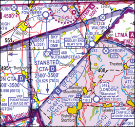
CTA-4west of the Stansted CTR adjoins the Luton CTA
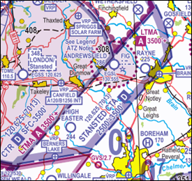
CTA-3 east of the Stansted CTR
Stansted has 15 Visual Reference Points (VRPs); all are signposted in UK AIP EGSS AD2.22.6; changes made in 2023 are now depicted on the latest VFR charts. For those pilots who use radio navigation techniques to navigate by, or as a back-up to visual navigation, there are 3 VOR/DME nearby to assist with cross-referencing positions from notified airspace boundaries:
| NAVAID | ID | FREQUENCY | NOTES |
| Barkway VOR/DME | BKY | 116.250 MHz | Under CTA-4 and 4NM from the CTR boundary |
| Brookmans Park VOR/DME | BPK | 117.500 MHz | 2NM from the boundary of CTA-2 and TMZ-2. |
| Lambourne VOR/DME | LAM | 115.600 MHz | 2.5NM from the boundary of CTA-2 and TMZ-2 and inside the Stapleford ATZ. |
If routeing between the Stansted and Luton CTRs, flying below altitude 2,500 feet direct between the VOR/DME of BPK and BKY, keeping to the west of the Ware and Puckeridge A10/A120 Interchange VRPs will ensure that you will not infringe Stansted controlled airspace.
In Threat and Error Management (TEM) terms, infringing controlled airspace is a ‘Threat’ then perhaps the ‘Error Management’ is utilising these NAVAIDs to assist with navigation.
Prevent an airspace infringement
The Airspace and Safety Initiative website provides extensive advice on how to avoid the risk of infringing airspace. Airspace infringements can be avoided by effective pre-flight planning, sound inflight decision making underpinned by the application of TEM. Below are some general Threats and Errors for Stansted Airspace and those that are more specific to aerodromes positioned within or beneath it.
| Threat | Error | Error Management |
| Infringing a CTA | Descending too late or climbing too early after departure or transit beneath a CTA | Plan your climb and descent using a geographical limit point; when joining and departing beneath a Stansted CTA, ensure you are 200 feet below controlled airspace. For example, when inbound to Andrewsfield, ensure you are at or below altitude 2,300 feet prior to transiting below CTA-3, or conversely, ensure you do not climb above altitude 2,300 feet until you have passed Braintree VRP on departure. |
| Infringing a TMZ | Entering a TMZ without a serviceable Mode S transponder operating to its maximum capability. | Double check your transponder is operating fully prior to departure, and again prior to entering the TMZ. Combat confirmation bias and include a transponder check even if you checked your transponder was operating on departure.
No transponder? Obtain a permission or, if operating at Hunsdon or North Weald, route via designated Areas of Operation. |
North Weald
(See hot-spot narrative 38: North Weald Aerodrome)
| Threat | Error | Error Management |
| Infringing TMZ-2 | Not turning on transponder prior to departure | Don’t rush your departure. Double check your transponder again once lined up. Think Lights Camera Action – landing lights, transponder on fully, no traffic on final or runway.
No transponder? Route via the Area of Operation via Epping VRP. |
| Infringing CTR | Flying wide visual circuits on Runway 20 or turning late after departure from Runway 02 | Ensure to turn prior to reaching the water tower which lies just within the CTR. If there’s traffic ahead, continue a normal pattern at circuit height rather than extending downwind. |
| Infringing CTA-2 | Planning to transit overhead North Weald aerodrome | North Weald is a busy aerodrome with a visual circuit height of 1,200 feet. You are likely to encounter circuit traffic and may instinctively climb into the CTA to avoid. If able, plan your route to avoid overflying North Weald. Maintain situational awareness by using North Weald Radio frequency on 123.530 MHz |
Andrewsfield
| Threat | Error | Error Management |
| Infringing CTR | Flying outside of the boundaries of the Andrewsfield (LFA). | The LFA ceiling is 1,500 feet AMSL; “Take 2” and operate no higher than altitude 1,300 feet. Make use of a VFR moving map device for lateral situational awareness |
Audley End
| Threat | Error | Error Management |
| Infringing CTR | Not making use of squawk 7010 in Audley End Area of Operation | Implement a limit point check to ensure 7010 is set prior to entry |
Hunsdon
(See hot-spot narrative 35: Hunsdon Microlight Site)
| Threat | Error | Error Management |
| Infringing CTR | Flying outside of the boundary of the Area of Operation | Remain west of the powerlines and keep circuits “tight” to remain within the area. “Take 1” from the area ceiling of 1000 feet AMSL. |
| Infringing TMZ-2 | Flying outside of the Area of Operation when not equipped with Mode S Transponder | Remain east of the powerlines and north of the bodies of water at Stansted Abbots. Alternatively, request a TMZ permission from Farnborough or Stansted Radar. |
In addition, pilots are strongly encouraged to:
Use a Moving Map which will provide a profile along your planned route showing the controlled airspace boundary and associated visual and aural warnings as you approach the airspace. When flying in proximity to Stansted controlled airspace, and if able to, Take 2.
Obtain an air traffic service from Farnborough North on channel 132.800 MHz.
Use a Frequency Monitor Code (FMC). Rather than squawking 7000/2000, if you do not want to obtain a service from ATC, use an FMC appropriate to the direction of flight; the Stansted FMC is 7013 with Stansted Radar (120.625 MHz). There are a further 3 FMCs in use in the vicinity of Stansted’s controlled airspace. Review the chart at ENR6.80 to understand the boundaries of the areas; this information is also replicated in AIC Y100/2022.
| Airport | ATSU | Channel | FMC |
| Luton | Luton Radar | 129.550 MHz | 0013 |
| Southend | Southend Radar | 130.780 MHz | 5050 |
| London City | Thames Radar | 132.700 MHz | 0012 |
Use the correct QNH. Obtain the Stansted QNH from the ATIS (127.180 MHz) or monitor Stansted Radar (120.625 MHz). ATIS also available on Clacton VOR (on frequency 114.550 MHz/channel 92Y).
Make a Detailed Plan. Build in your climb and descent points when planning your route. Use satellite imagery to know what VRPs look like and what airspace lies above them or close by. Prepare a PLOG listing frequencies of useful adjacent ATSU/aerodromes that may need to be called such as:
| Stapleford ATZ | Stapleford Radio | 122.805 MHz |
| Andrewsfield ATZ | Andrewsfield Radio | 130.555 MHz |
| Earls Colne ATZ | Earls Colne Radio | 122.430 MHz |
| Duxford ATZ | Duxford Information | 122.080 MHz |
| North Weald | North Weald Radio | 123.530 MHz |
If appropriate – request a clearance. If for any reason a climb into the CTA, or a turn into the CTR is (or may be) required then a clearance must be obtained from Stansted Radar before entering controlled airspace.
Air Traffic Controllers are there to help. If in doubt, contact Stansted Radar on 120.625 MHz for assistance.
Preventing airspace infringements of Controlled Airspace
NOTICES TO AIRMEN (NOTAM) RELATING TO CONTROLLED AIRSPACE DEACTIVATION
This infringement update is the seventeenth in a series of narratives focusing on helping pilots avoid airspace infringements in the UK. It has been written by a number of industry partners to help pilots better understand NOTAM relating to the deactivation of controlled airspace.
We are all experiencing strange times in aviation; COVID-19 and the associated overseas travel restrictions have reduced commercial air transport (CAT) to all but a trickle with freight flights outnumbering the previously packed airport schedule of passenger flights. With demand for air transport low and many Air Navigation Service Provider (ANSP) and airport staff furloughed, several airports are operating revised or reduced hours. Consequently, the need for H24, Class D Control Zones (CTR) and Control Areas (CTA) has reduced and many airports are deactivating controlled airspace to Class G when the airport closes.
A thorough check of the NOTAM validity is essential as some of these can be changing daily with short-term notification of activity. Some NOTAM are providing guidance to use the Frequency Monitoring Code [FMC] (sometimes referred to as a “Listening Squawk”) and monitor the appropriate frequency, even when the ATS is closed as a defensive measure just in case the airspace is activated between the time you plan and fly.
As a result of these deactivations, some Moving Map applications depict the airspace boundaries in rarely seen colours and may visually show airspace being deactivated throughout the NOTAM period, when in fact the airspace is only classified as Class G for certain periods of time (the schedule) within the NOTAM period.
In the first 2 weeks of the resumption of GA sport and recreational flying (beyond that permitted for maintenance flights), there were 47 airspace infringements, 40 of which involved GA aircraft. A number resulted from the mis-interpretation of NOTAM relating to the deactivation of controlled airspace. If you are unsure about the NOTAM, its content or how to interpret some of the information, this narrative should help to make the NOTAM more understandable.
NOTAM structure
A NOTAM comprises several Fields (A-G) and a Q Line. The NOTAM is constructed in accordance with Operating Procedures for AIS Dynamic Data (OPADD) defined in ICAO Annex 15. The current OPADD is Edition 4.
The NOTAM’s Q line is a coded line which contains the reference FIR and a series of letters denoting the type of activity. It also contains the central point in Degrees and Minutes and the radius in nautical miles (NM) of an area which encompasses the entire activity. This is why, on some Moving Maps, an activity area such as a polygon is sometimes depicted as an even larger circle. The Q line is used for Aeronautical Information Management purposes and offers little flight planning information to pilots.
The fields (all or some which may be used depending on the NOTAM series being used) relate to:
| A | ICAO code for FIR or aerodrome |
| B | Start time in UTC |
| C | Ends time in UTC |
| D | Daily Schedule |
| E | Free text field describing the activity iaw OPADD |
| F | Lower level of activity |
| G | Upper level of activity |
All NOTAM use UTC. Care must be taken in the summer months due to the one-hour time difference in the UK between UTC and local.
NOTAM Series
There are currently 18 NOTAM series in use in the UK; they can be found in the UK AIP at GEN 3 .1 (Aeronautical Services) table 3.6.3.4. Each series covers a specific content. For example, a NOTAM relating to London Heathrow will be an A series NOTAM, a similar one for Birmingham would be a C series. Unusual Aerial Activity (UAA) is notified using an H series NOTAM as it relates to a navigation warning. The establishment of a volume of Restricted Airspace (Temporary) (RA(T)) or a Temporary Danger Area (TDA) would be promulgated by a J series NOTAM.
Controlled Airspace Deactivation NOTAM
A number of CTA/CTR are deactivated at certain times through the day; these changes in classification are notified by NOTAM which is then annotated on Moving Map displays. One such volume of airspace subject to declassification is the airspace around Birmingham. An example is NOTAM C3627/20 which deactivates Birmingham’s CTR and CTA between 2259 hours UTC and 0559 hours UTC on each day starting on 2 June 2020 and ending on 30 June 2020 (see FIGURE 1).
In decoding this NOTAM, the following information is provided:
| Q Line | Birmingham Airport and the subject airspace (CTR/CTA) encompassed in a 20nm radius centred at 5225N 000152W | |
| A | ICAO code for Birmingham Airport | EGBB |
| B | Start time in UTC | 2259 hours UTC on 2 June 2020 |
| C | Ends time in UTC | 0559 hours UTC on 30 June 2020 |
| D | Daily Schedule | Each day from 2259 hours UTC to 0559 hours UTC |
| E | Free text field | Description of activity in clear words or using abbreviations in OPADD |
| F | Lower level of activity | Not used in this series |
| G | Upper level of activity | Not used in this series |
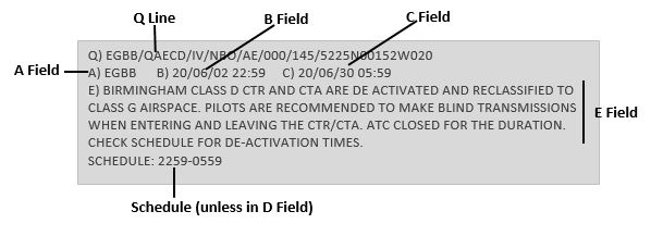
FIGURE 1
If the airspace was deactivated for the entire period from 2259 hours on 2 June 2020 until 0559 hours on 30 June 2020, the NOTAM would not contain a schedule (D field)
Some locations that need to open ad hoc will add extra information for pilots such as listening out on the appropriate FMC frequency, and squawking the appropriate FMC code. Note that you should listen out FIRST, THEN set the squawk code with altitude [ALT] (MODE A and C). This will allow the Air Traffic Service Unit (ATSU) to quickly identify aircraft within the lateral/vertical confines of the airspace in the minutes running up to reactivation of controlled airspace. An example of the extra information that a NOTAM might contain in these circumstances is shown below:
PILOTS ARE REQUESTED TO MAKE BLIND CALLS ON SOLENT 120.230 AND MONITOR UNTIL CLEAR. SQUAWK MONITOR 7011 FOR SOLENT/SOUTHAMPTON IS ADVISED. IF DEPARTING FROM A SITE WITHIN THE ATZ/CTR, TRY CALLING SOUTHAMPTON ATC ON THE LANDLINE OR MAKE BLIND CALLS WHILST ON THE GROUND TO SOLENT 120.230 MHZ.
When there is overlapping airspace with neighbouring units, pilots should be aware that there is a possibility of different ATC unit operating hours. Even if CTAs are deactivated, airspace delegated to neighbouring units might still be active. An example of this is in the Solent area with Southampton and Bournemouth ATSUs. In FIGURE 2, NOTAM B1353/20 clearly guides pilots which FMC to use in the area. This also acts a reminder that part of the Solent CTA is routinely delegated to Bournemouth. The line Stoney Cross–Beaulieu-Needles is the published FMC boundary and when using an FMC and flying west of that line, pilots should select the Bournemouth radar frequency of 119.475MHz and squawk Bournemouth’s FMC (0011) irrespective of Solent opening hours and any deactivation of CTA/CTR.
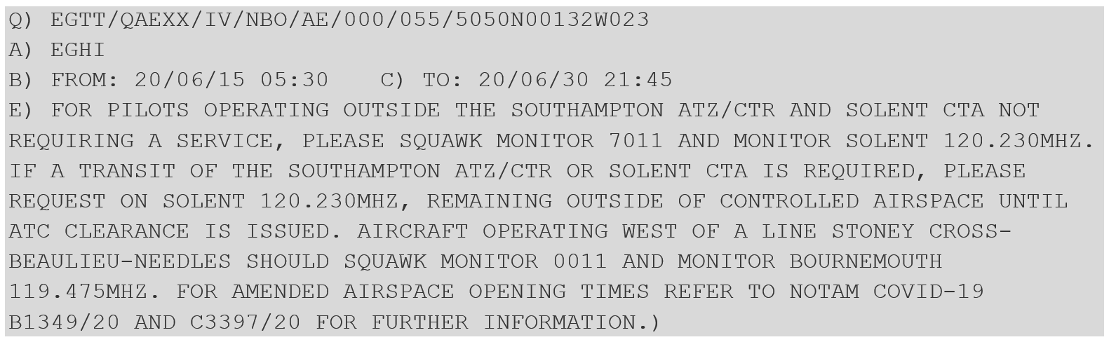
FIGURE 2
Moving Map Depiction
Not all Moving Map depictions for airspace deactivation NOTAM are the same. For example, SkyDemon uses a colour coding system. When airspace is activated it is outline in red/orange and when deactivated it is outlined in green. The associated NOTAM has a similar colour banner shown in FIGURE 3.
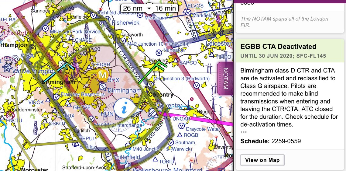
FIGURE 3
Care must be taken to review and decode the NOTAM correctly. The Green boundary will be shown H24 until 0559 hours UTC on 30 June 2020 because a NOTAM exists to deactivate the Class D airspace; it does not indicate that the airspace is declassified H24 unless that is stated in NOTAM. Only by expanding the NOTAM as shown in FIGURE 4 will you see the scheduled times of ‘2259 – 0559’.
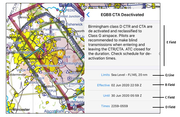
FIGURE 4
REMEMBER when planning and carrying out your flight that the existence of a green boundary does not necessarily mean that the Class D airspace is deactivated. It is vital that the schedule is referred to so that you are aware whether a clearance to enter the CTR/CTA is required due to the airspace being Class D.
Other Information in the E Field
A telephone number will be included in many H series NOTAM relating to unusual aerial activity (UAA). This is an agreed contact number of the activity sponsor that will be available while the NOTAM is effective. On occasions, for example, a 15-minute flying display may be subject to a 2-hour window for a variety of reasons ranging from weather contingencies, transit from previous displays or finalisation of the event programme at the point when the NOTAM was submitted into the European AIS Database. During the pre-flight planning stage of your flight, you can call the sponsor to establish a more accurate time of the activity thereby possibly negating a re-route to avoid the activity. If the sponsor is contacted who states that the activity the NOTAM refers to has either been cancelled or has a later start time, or an earlier finish time, then it is perfectly permissible to accept these as the new start/finish times for the NOTAM concerned.
Some parachuting activity takes place in an inverted cone of airspace. The E field of the NOTAM will contain a number of values showing the radius of the activity at different altitudes. The Q line, and possibly the depiction on Moving Maps, will show a circle based on the highest altitude (and therefore largest radius) where the parachutists will vacate the aircraft and then drift to the drop zone (DZ) whilst descending through the cone of activity. The NOTAM is depicted as a circle with the centre based on the DZ since at the time of NOTAM submission the winds will be unknown. However, in reality the activity will usually take place in the upwind part of the depicted circle.
The NOTAM in FIGURE 5 relates to one such parachute jumping exercise (PJE). If you are planning to fly at 3,000 feet amsl, good airmanship dictates that you should remain 4NM from the DZ at 515246N 0011320W as you may encounter parachutists between 1100 hours UTC and 1800 hours UTC; if you are planning to fly at 1,500 feet amsl, the radius is only 2NM.
Should you wish to speak to the event sponsor to check on the status of this activity, you could do so on 07970 363xxx. On Moving Maps, this NOTAM would be displayed with a circle of 10NM as that is the maximum radius of the activity but only between 6,001 feet amsl and 15,000 feet amsl.
FIGURE 5
Prevent an airspace infringement
This website includes extensive advice on how to avoid infringing airspace. Reviewing other hot-spot narratives as part of your pre-flight planning will offer a great deal of useful advice. Pilots are strongly encouraged to:
- Pre-flight plan that incorporates all aspects of the flight including the departure, en-route and arrival phases of the flight should be detailed, unrushed and focussed. The planning should incorporate Threat and Error Management (TEM). Make a Plan B as part of your TEM. There is a requirement to plan for every flight even if you are getting airborne to fly visual circuits; NOTAM and weather must be briefed.
- Use a Moving Map which will provide a profile along your planned route showing the controlled airspace boundary. Know exactly how your chosen Moving Map depicts airspace, UAA and alerts and pay attention to, and note, the alerts before cancelling/accepting them.
- Take 2. When able Take 2. Apply TEM when planning your route and altitude. By ‘Taking 2’ you will have time to recover from distractions and external threats such as conflicting aircraft prior to infringing airspace.
- Make use of an Air Traffic Service. Note the frequencies along your route, print off a PLOG and plan your transmissions.
- Use a Frequency Monitor Code (FMC). Rather than squawking 7000/2000, and if you do not want to obtain a service from ATC, use an FMC appropriate to the direction of flight. FMCs have proven to prevent infringements and reduce the severity of such occurrences.
The full set of hot-spot narratives can be found on this page: Local area information
Preventing infringements in the vicinity of Southend
UPDATED August 2022
This infringement update was originally issued in 2021 as the eighteenth in a series of narratives focusing on identified infringement ‘hot-spots’ in the UK.
It has been written by the team at Southend Airport Air Traffic Control. It is now being reissued ahead of AIRAC 09/2022 which becomes effective on 8 September 2022 and results in a lateral expansion of CTA-10
There have been 55 reported infringements of the Southend Control Zone and Control Areas since 2019. A large percentage of these infringements were by aircraft that made a late request for a transit whilst very close to, or already having crossed, the Controlled Airspace (CAS) boundary.
The Southend CAS complex includes 3 Control Zones (CTR) and 10 Control Areas. All are Class D airspace.
The Southend CAS complex
| AREA | VERTICAL LIMITS |
| CTR-1 | SFC – 3,500 feet |
| CTR-2 | SFC – 4,500 feet |
| CTR-3 | SFC – 5,500 feet |
| AREA | VERTICAL LIMITS | AREA | VERTICAL LIMITS |
| CTA-1 | 1,500 – 3,500 feet | CTA-6 | 2,500 – 5,500 feet |
| CTA-2 | 1,500 – 4,500 feet | CTA-7 | 2,500 – 3,500 feet |
| CTA-3 | 1,500 – 5,500 feet | CTA-8 | 3,500 – 5,500 feet |
| CTA-4 | 2,500 – 3,500 feet | CTA-9 | 3,500 – 4,500 feet |
| CTA-5 | 2,500 – 4,500 feet | CTA-10 | 3,500 – 5,500 feet |
To prevent infringement pilots are encouraged to consider the following as part of their pre-flight planning and in-flight execution.
Aircraft planning to cross/enter Southend CAS
Use a VFR moving map
To give you a profile along your planned route showing controlled airspace above and around your route along with any airspace warnings. Ensure that alerts are configured correctly on the APP to warn about airspace along the route.
Make requests for a transit clearance as early as is practically possible
Give yourself plenty of time (ideally 5 minutes prior to Southend CAS boundary) to be able to request and receive a transit clearance. Southend LARS (130.780 MHz) can handle over 200 aircraft on some days and therefore the frequency can become incredibly busy. Giving yourself more time will reduce your workload and decrease the chance of entering CAS without a positive clearance and reduce the chance of you having to take delaying action or change your level.
Have a point beyond which you are not going to fly, or where you will have to change your route or level, if you have not received a clearance to enter controlled airspace. Mark this on your chart and add it as a waypoint on your VFR Moving Map as a trigger point.
On days where the Southend Radar frequency becomes busy, Southend controllers will ‘split’ the radar into two separate positions to help manage traffic and RT loading more efficiently. Aircraft that request a transit may be instructed to contact Southend Director on 128.965 MHz. Being instructed to contact Southend Director does not give you permission to enter Southend CAS unless a positive clearance to do so has already been obtained.
Make a detailed plan
Southend offers a flexible approach to CAS transits and will try to accommodate all users when able. However, depending on a variety of factors such as traffic situation and runway in use, the route that you request may not always be immediately available or practical.
Plan for the possibility of alternative routings, changing levels (i.e. descending below CTA) or having to hold outside CAS whilst waiting for a clearance to be given. Know the location of the Southend Visual Reference Points (VRP) and what they look like (see below).
When planning a route that involves flying through a runway extended centreline, consider the possibility of being given an alternative routing that takes you to a VRP or via the Southend overhead.
Southend Radar is more likely to be able to accommodate a clearance that is perpendicular to the runway centrelines and close to the airfield i.e. Routing South Woodham Ferrers (VRP), overhead the airfield and Sheerness (VRP) and the reciprocal.
Visual Reference Points
Southend has 8 Visual reference points (VRPs) as follows:
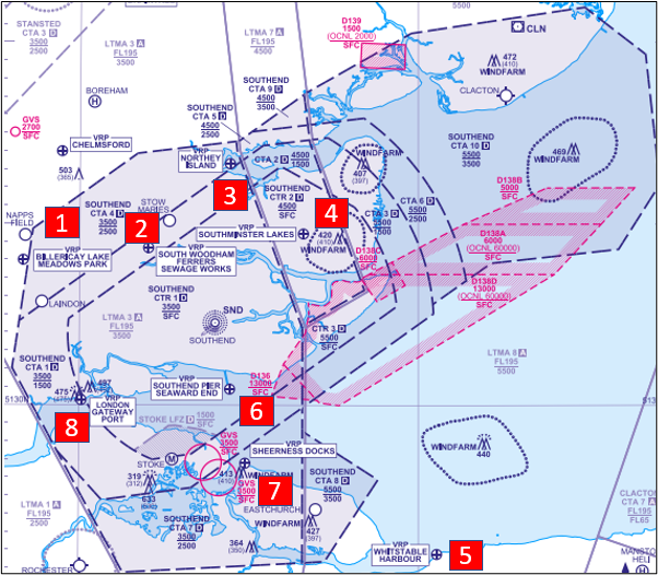
Southend’s 8 Visual Reference Points
1 Billericay Lake Meadows Park. (North of Billericay train station)
Location: 11NM northwest of Southend just before CTA-4 of Southend CAS
Pilots approaching Billericay towards Southend may need to be already in the descent to remain outside Southend CAS (Base 2,500 feet at CTA-4).
2 South Woodham Ferrers Sewage Works (NE of South Woodham Ferrers Town)
Location: 5.5NM north northwest of Southend. Underneath Southend CTA-1 (base 1,500 feet) and 0.5NM from the Southend CTR
Used by VFR aircraft departing Southend. Often used by Southend Controllers for joining and transit aircraft as the VRP is perpendicular to the Runway extended centrelines. Aircraft flying in the vicinity of South Woodham Ferrers are encouraged to contact Southend ATC due to the busy nature of this VRP and the vicinity of aerodromes such as Stow Maries Great War Aerodrome.
3 Northey Island (East of Maldon/Heybridge Basin in the River Blackwater)
Location: 9NM north northeast of Southend. Underneath Southend CTA-4 (base 2, 500 feet) and 0.5NM from Southend CTA-1 (base 1,500 feet)
Aircraft wishing to transit Southend CAS from the north are encouraged to contact Southend Radar 5 minutes before Northey Island VRP.
4 Southminster Lakes (South of Southminster train station)
Location: 7NM northeast of Southend inside Southend CTR (base surface)
5 Whitstable Harbour
Location: 18NM southeast of Southend under London Control Area (LTMA) (base 5,500 feet)
Aircraft wishing to transit Southend CAS from the southeast are encouraged to contact Southend Radar no later than Whitstable Harbour VRP.
6 Southend Pier Seaward End (Pier with cultural centre)
Location: 3NM south of Southend inside CTR (base surface)
Often used to hold joining aircraft from the South during busy periods. VRP is perpendicular to runway centrelines so may be used to route transit aircraft.
7 Sheerness Docks (Fortification)
Location: 7.5NM south southeast of Southend underneath CTA-7 (base 2,500 feet) and 0.5NM from CTA-1 (base 1,500 feet)
Used by VFR aircraft departing Southend. Often used by Southend Controllers for joining and transit aircraft as the VRP is perpendicular to the Runway extended centrelines.
8 Gateway Port (Large Cargo Port on Thames Estuary)
Location: 8NM southwest of Southend underneath Southend CTA-1 (base 1,500 feet) and 0.5NM from CTR
Depending on Runway in use used to route transit aircraft. As it is located on the Runway extended centreline, pilots may be given a clearance with a “not above” altitude restriction.
Aircraft flying in the vicinity of Southend CAS
Use a VFR moving map
To give you a profile along your planned route showing controlled airspace above and around your route along with any airspace warnings. Ensure that alerts are configured correctly on the APP to warn about airspace along the route.
Request a Lower Airspace Radar Service (LARS) from Southend Radar
Pilots can request a LARS from Southend radar on 130.780 MHz between 0900L-1800L. Outside these hours the Southend Radar frequency is still monitored, and a service can be requested.
Use the Frequency Monitoring Code (FMC)
Rather than squawking 7000/2000, use the Frequency Monitoring Code by squawking 5050 and monitoring Southend Radar on 130.780 MHz. If aircraft are fitted with Mode S transponders the Southend controller will be able to see your Flight ID (callsign) on their radar display and will be able to call you if they observe you approaching or about to enter CAS. Aircraft should not hesitate to establish contact with Southend Radar if they require any assistance or are unsure of their position.
Make a detailed plan
The airspace in the vicinity of Southend is very complex with the Southend, Stansted and London City CTAs in close proximity along with changing levels to the base of the London TMA. Build in your climb and descent points when routing in the vicinity of multiple CTA/LTMA with the differing base altitudes. Know what VRPs look like and what airspace lies above them or close by.
Take 2
As part of Threat and Error Management, pilots are advised to maintain adequate separation from notified airspace through the application of the ‘Take 2’ guidance (where able, plan to remain at least 2NM from the edge or 200 feet below the base of the subject airspace) to avoid airspace infringements. The recommended 200 feet distance may need to be increased during flights where turbulence or thermic conditions are encountered to prevent inadvertent climbs into controlled airspace.
If appropriate – request a CAS crossing clearance
If for any reason a climb is required above the base of the Southend CTA, then a clearance must be obtained. Depending on a variety of factors, not least the runway in use and traffic situation at the time, this may well be available. By obtaining a clearance to enter controlled airspace when appropriate, Southend ATC can control more effectively and ensure safety is maintained.
More information
- CAA Safety Sense 29: VFR Moving Map Devices
- Airspace Safety Initiative: Pre-flight planning
- Airspace Safety Initiative: Threat and Error Management
- UK AIP Aerodrome Directory – Southend (AD EGMC) – AIP via NATS AIP Aeronautical Information Publication
Preventing infringements of the Farnborough Controlled Airspace in the vicinity of Blackbushe Airport
This infringement update has been written by the team at Blackbushe Airport, Farnborough Air Traffic Service Unit and members of the Wessex Local Airspace Infringement Team.
Blackbushe Airport has a standard Aerodrome Traffic Zone (ATZ) of 2NM radius which extends from the surface to 2,325 feet AMSL (2,000 feet AAL). Part of the Blackbushe ATZ lies within the Class D Farnborough Control Zone (CTR-1). The area of overlap between the Blackbushe ATZ and Farnborough CTR-1 forms the Blackbushe LFA. The LFA extends to 2,000 feet AMSL (1,675 feet AAL) and its dimensions are promulgated in in the UK AIP at AD2.22.4 LOCAL FLYING AREA. It is shown in Figure 2 which is published on the Blackbushe Airport website at www.blackbusheairport.co.uk/aerodrome.
SVFR operations within the LFA require a clearance from Farnborough Radar, and are required to be separated from other SVFR/IFR aircraft. As a result, issuance of such a clearance from Farnborough Radar would be available to only one aircraft at a time.
Additional conditions apply when operating under special VFR. See EGLK AD 2.22.5 SPECIAL VFR IN THE LOCAL FLYING AREA.

Blackbushe LFA
Aircraft JOINING/OPERATING in the Blackbushe Visual Circuit
Runway 25
The majority of the airspace infringements to date have resulted from pilots extending downwind in the Runway 25 visual circuit (Figure 3) and leaving the LFA in the vicinity of Hawley Lake. The AIP entry for the LFA states “Pilots are required to contain their circuits within the LFA and ATZ. In particular, on Runway 25 note to turn base leg west of Hawley Lake (Figure 4) to avoid infringing the CTR to the east.” In addition, on the Blackbushe Airport Information page pilots are advised to “Turn Base Leg before reaching Hawley Lake (Figure 4) to ensure circuits remain inside the ATZ/LFA. If aircraft ahead are establishing a wider circuit, do not follow, but reposition deadside or orbit as appropriate, and in communication with ATSU.”
If the visual circuit is extending to the east and there is a possibility that you might leave the LFA, make a positive, early decision to reposition deadside for another circuit; DO NOT extend over or to the east of Hawley Lake.

Blackbushe Runway 25
Hawley Lake
Runway 07
When joining for Runway 07 turn base leg when joining or descending deadside, take care to remain west of Yateley. Follow the path of disused runway 14/32, keeping it to the left at all times.
Turn Base Leg before reaching The Elvetham Hotel (and abeam Fleet Services) (Figure 6) to ensure circuits remain inside the ATZ/LFA. If aircraft ahead are establishing a wider circuit, do not follow, but reposition deadside or orbit as appropriate, and in communication with ATSU.
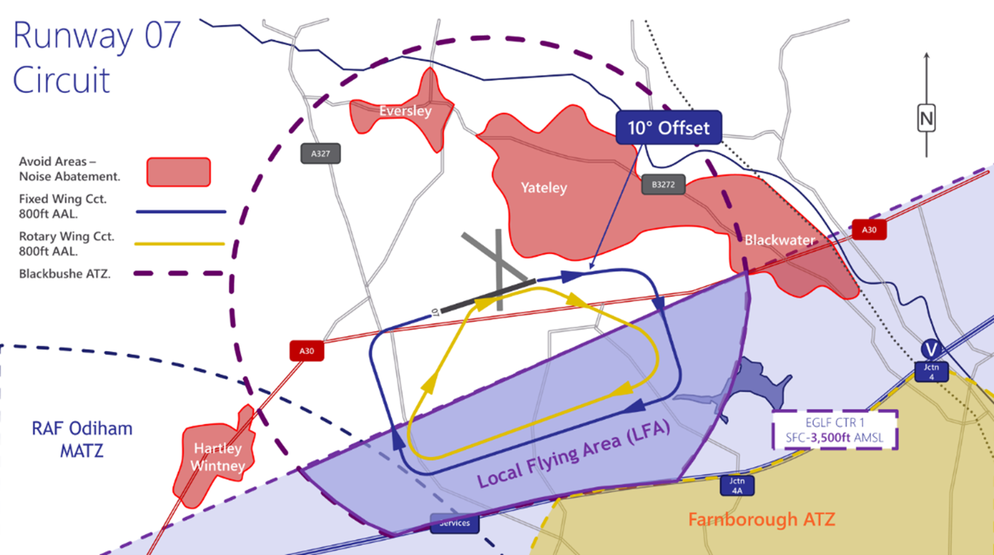
Blackbushe Runway 07
Elvetham Hotel and Fleet Services
If you are re-joining the circuit, you must ensure that you are squawking 7010 prior to entering the LFA. Where you are entering the LFA from the south (within the Farnborough CTR-1), you may either retain the squawk issued for your transit, or select 7010 once North of the M3.
General Circuit Procedures
Circuit Procedures
- Circuits are always to the south of the Airfield and are flown at 800 feet QFE for most fixed wing aircraft.
- For jet, turbo-prop, or other high-performance traffic, circuits are flown at 1,200 feet QFE.
- Rotary wing circuits are flown at 800 feet QFE typically inside the fixed wing circuit. All pilots should be aware of rotary traffic using non-standard circuits when using the Helicopter Training Area to the south of Runway 07/25.
- Pilots must remain north of the M3 motorway to avoid infringing the Farnborough ATZ/CTR.
- In the interests of safety, orbits in the circuit are generally not permitted, but may be required on occasion due to the range of aircraft with different performance characteristics. Should orbits be required they should first be declared, and then be executed in the direction of the circuit.
- Unless in an emergency, aircraft must observe the Rules of the Air for aerodromes at all times.
Aircraft DEPARTING Blackbushe Airport
Another area in which airspace infringements have occurred are during the departure phase, in particular from Runway 07 where a ‘wrap around’ departure is required to avoid the noise abatement areas associated with Yateley. The Blackbushe airport website gives clear guidance as follows.
Runway 25 Departures
“If departing to the North or West, straight out departures are permitted with a right turn to avoid overflying Hartley Wintney (Figure 7) and avoid entering controlled airspace to the South.
If departing to the Southwest, South or East, a clearance must be sought to enter the Farnborough CTR/CTA”.
Runway 07 Departures
“On climb out, a turn 10° to the south must be made to avoid Yateley.
Unless in an emergency, all turns must be to the south. To leave the circuit, climb on the downwind leg into the overhead, remaining outside controlled airspace by remaining below 2,000 feet AMSL (1,675 feet AGL) unless in receipt of a clearance from Farnborough Radar.”
The important point to note to avoid infringing the Farnborough CTR-1 is that departing aircraft must maintain below 2,000 feet AMSL (1,675 feet AGL) until clear of the lateral confines of the LFA to the west and north. Care must be taken when departing to the southwest not to inadvertently enter the CTR if you are not in receipt of an air traffic clearance to enter the CTR.
Hartley Wintney
Preventing an airspace infringement when operating at Blackbushe Airport
The key to avoiding airspace infringements when operating to/from/at Blackbushe is to have a thorough understanding of the airspace structures and local operating procedures.
When operating in the Blackbushe circuit always remain in the LFA.
When flying downwind for Runway 25, turn base leg before reaching Hawley Lake. If the aircraft ahead of you is flying wide circuits, go around early and reposition for another circuit.
When flying downwind for Runway 07, turn base leg before the Elvetham Hotel (abeam Fleet Services).
When departing from Runway 07, turn right downwind and remain below 2000 feet AMSL (1675 feet AGL) until clear of the LFA.
Prior to each flight into/from Blackbushe, review local procedures as part of your pre-flight planning. These are clearly explained at:
- United Kingdom AIP EGLK AD2.22 (Flight Procedures) (http://www.nats-uk.ead-it.com/)
- Blackbushe Airport website (Pilot Information) (https://www.blackbusheairport.co.uk/aerodrome)
- Airspace and Safety Initiative website (Hot-spot narrative and Local Airspace Infringement Teams – Narrative 10 ) (https://airspacesafety.com/local-area-information/)
Aircraft Flying in the vicinity of Farnborough CAS
The Airspace & Safety Initiative website provides extensive advice on how to avoid the risk of infringing airspace. You are strongly encouraged to:
- Use a VFR Moving Map. In many airspace infringements, pilots were either found not to be using a VFR Moving Map or not using one correctly. This was particularly evident during instructional flights where instructor workload is high and distractions highly likely. Using Moving Maps not only gives pilots a profile along the planned route showing controlled airspace above and below the route, but it offers airspace warnings. Moving Map technology should not be the sole means of planning or navigation as highlighted in the European General Aviation Safety Team’s Safety Promotion Leaflet and the UK CAA Safety Sense leaflet.
- When flying in proximity to controlled airspace, and able to, pilots are strongly encouraged to apply the Take 2 guidance and operate on the most appropriate altimeter setting when operating under a CTA. In the case of the Farnborough CTA-1, the Farnborough or London QNH are all acceptable. Consider increasing this distance in cases of thermic or turbulent conditions or where you lack experience or are subject to skill fade. The ‘Take 2’ initiative is neither a buffer based on State policy, nor is its application mandatory; it is merely guidance based on the principle of good airmanship, introduced by pilots to help their fellow pilots and other airspace users.
- Understand the impact of forecast weatheron your flight. Thermic or turbulent conditions can inadvertently push you upwards. Use the regulated Met Office Aviation Briefing Service; the site provides not only TAFs and METARs but Met Forms F214, F215, GAMETs and satellite imagery. In addition, refer to Farnborough and Heathrow METARs/TAFs to better visualise local conditions and how they might affect your flight.
- Obtain a Lower Airspace Radar Service (LARS)from Farnborough Radar. Pilots can obtain a LARS from Farnborough Radar in this area on 125.250 MHz; the hours of operation are listed in the UK AIP EGLF AD2.18 or subject to NOTAM action if different.
- Use the FMC rather than squawking 7000/2000. Pilots are encouraged to obtain an Air Traffic Service (ATS) from Farnborough Radar on 125.250 MHz or to monitor 125.250 MHz and squawk the Frequency Monitoring Code of 4572. Obtain the Farnborough QNH by listening to that given to other aircraft on 125.250 MHz. It may also be obtained from the Farnborough ATIS channel 128.405.
- Apply Threat and Error Management when planning and flying. Always consider airspace when making a detailed plan. Build in climb and descent points when routing in the vicinity of multiple CTAs with differing base altitudes. Know what VRPs look like and what airspace lies above them or close by. Have a point beyond which you are not going to fly if you do not have a positive clearance to enter controlled airspace when departing from Fairoaks or Blackbushe Airport when cockpit workload is high. One of the biggest causes of infringements is distraction; manage that Threat when operating close to controlled airspace.
- If appropriate – request a clearance from Farnborough Radar on channel 133.440. If for any reason a climb is required above the base of the CTA, then a clearance must be obtained prior to entering the CTA.
This hot-spot narrative was updated in December 2025.
Preventing infringements of Prohibited and Restricted Airspace
This infringement update is the twentieth in a series of narratives focusing on identified infringement hot-spots in the UK. It has been written by the airspace sponsors involved in the establishment of permanent and temporary prohibited and restricted airspace.
Each year a number of pilots infringe prohibited or restricted airspace in the UK. There are three types of such airspace:
- Prohibited and Restricted Airspace;
- Restricted Area (Temporary) also known as a RA(T); and
- Emergency Restrictions of Flying, known as ERF.
Irrespective of the type of area, all three are established under article 239 of the Air Navigation Order 2016 (ANO2016) [as amended] on behalf of the Secretary of State. The regulations made under this article may apply either generally or in relation to any class of aircraft as notified and it is an offence to contravene, permit the contravention of or fail to comply with any regulations made under this article.
Power to prohibit or restrict flying
239.(1) If the Secretary of State decides it is necessary in the public interest to restrict or prohibit flying by reason of—
(a) the intended gathering or movement of a large number of persons;
(b) the intended holding of an aircraft race or contest or of a flying display; or
(c) national defence or any other reason affecting the public interest,
the Secretary of State may make regulations prohibiting, restricting or imposing conditions on flights by aircraft specified in paragraph (2) flying in the circumstances specified in paragraph (2).
(2) The aircraft and circumstances are—
(a) aircraft, whether or not they are registered in the United Kingdom, in any airspace over the United Kingdom or in the neighbourhood of an offshore installation; and
(b) aircraft which are registered in the United Kingdom, in any other airspace, being airspace for which the United Kingdom has, under international arrangements, undertaken to provide navigation services for aircraft.
All types of area are established by secondary legislation through a Statutory Instrument (SI) and notified by a variety of means. Notifications comprise a volume of airspace and a list of types of operations that are exempt the restrictions (such as Police Helicopters, Helicopter Emergency Medical Services etc) or a means by which a pilot may request access to the area. This may be granted as:
- a clearance issued by an ATC unit named in the SI; or
- a permission issued by an individual, a function (such as Flying Display Director or Explosive Ordnance Disposal Unit), FISO or AGCS unit.
In 2019 there were 22 infringements of restricted airspace; 6 in permanent areas, 15 in RA(T)s and one in an ERF. This article is intended to provide some knowledge of these types of airspace structures and guidance and useful tips to assist pilots in preventing infringing them.
Prohibited and Restricted Areas
A Prohibited area is an area within which flight is prohibited. There are currently 2 Prohibited Areas in the UK and are listed in the UK AIP ENR (En-Route) section 5.1 (ENR 5.1); both surround nuclear establishments in Scotland. Both areas are assigned a 3 letter and 3 number code. The letters are EG (the designator for the UK) and P for Prohibited; the initial number relates to the position in degrees of latitude e.g. P813 at 58oN.
A Restricted area is an area within which some flying is restricted. As with prohibited areas, all are listed in the UK AIP at ENR 5.1. There are over 40 areas in the UK and they are found around nuclear installations, high-security prison sites, royal residences, areas of Central London and some military establishments. Each area is assigned a 3 letter (EG R) and 3 number code as for Prohibited Areas, e.g. R036 for 50oN. One area is designated as an EG RU (Port of Dover) as it is only applicable to Unmanned Aircraft Systems, hence the U.
The areas are charted as a magenta hatched area and annotated as, for example P813 or R220. The altitude is shown in thousands of feet (2.1 meaning 2,100 feet) and is AMSL (see FIGURE 1). In one area the altitude is Unlimited (UNL).
FIGURE 1: Prohibited and Restricted Areas
The entry in the UK AIP ENR 5.1 notifies the dimensions and the exceptions to the restrictions when, or under what criteria flight, is permitted. Once a permission or a clearance is granted to enter the area, it is still cognizant on the pilot to comply with other aviation legislation such as the ANO2016, Standardised European Rules of the Air (SERA) or the Rules of the Air 2015. As part of pre-flight planning, if your flight will be in the vicinity of a Prohibited or Restricted Area, it is good practice to review the AIP entry to understand the entry conditions.
Restricted Area (Temporary) (RA(T))
The onset of COVID-19 forced the cancellation of many air displays, festivals and major sporting events. However, prior to 2020, each year some 80-90 RA(T) were established under article 239 of the ANO2016; as the UK comes to terms with the pandemic, events will undoubtedly start to be arranged that will require the protection through RA(T) which will require the awareness of airspace users.
Established to ensure the safety of participants or attendees or for national security reasons, these temporary airspace structures, are notified via a J-series NOTAM and, whenever time permits, through the issuing of a MAUVE Aeronautical Information Circular (AIC). AIC’s can all be found on the NATS AIS website. Just click IAIP (at the top) and they are within the Aeronautical Information Circulars link. White, Yellow, Pink Mauve and Green AIC will all be displayed. M064/2019 would have been found in the Mauve section.
For complex structures where the AIC 28-day publishing schedule cannot be met, the CAA team will aim to issue a Briefing Sheet on the NATS AIS News page (http://www.nats-uk.ead-it.com/public/index.php.html). In addition, details of RA(T) are available on a daily basis on the NATS AIS Telephone Information Line; two numbers are available as follows: 08085-354802 or +44(0)1489-887515. The recorded message will give brief details of any restrictions on which you can then brief yourself using the UK NOTAM system (for example via the NATS AIS website) or on Moving Map software.
A RA(T) will always be designed to restrict flight using the minimum amount of airspace to achieve the aim. Whilst most are circles of a specified radius, some RA(T) can be more complex in shape. To assist you in interpreting the list of coordinates forming the boundary, each AIC will include a chart of the area. When operating in the vicinity of a RA(T), it is essential that a good lookout is maintained for other traffic which may be routing abound the area. In addition, for air display RA(T), participants, including fast-jets and large aircraft or formations may be holding outside the RA(T) awaiting a display slot-time and clearance to ‘run-in’.
As RA(T) are specific to individual locations and events, an air show with slower and lower display participants will a have a smaller RA(T) than one which has, for example, fast-jets. This allows the protection of the aircraft engaged in display manoeuvres from unknow traffic but does not restricted transit traffic through the area disproportionately. Due to the manoeuvres associated with displaying a large-formation team, such as the Red Arrows, these shorter, individual displays, although part of the bigger event, require a larger volume of restricted airspace. For a standard display, in anticipation of a full show, the Red Arrows will be granted a 45-minute cylindrical RA(T) extending to 8,000 feet agl (depending on other airspace structures) within a circle of radius of 6nm centred on the Team’s display datum.
When planning a flight in the vicinity of an air show, it is important to consider all restrictions in 4 dimensions to ensure that the correct volume of airspace is avoided at the relevant times, for example:
| AIR SHOW 1
e.g. Bournemouth |
AIR SHOW 2
e.g. Rhyl |
|
| Air Show | Rectangular RA(T) 5nm x 8nm SFC – 5,500 feet amsl Daily 1200-1600 hrs UTC for 4 days |
Circular RA(T) Circle 3nm radius SFC-4,000 feet amsl 1100-1600 hrs UTC |
| Jet Formation Display Team | Circle 6nm radius SFC-8,000 feet amsl Day 1: 1200-1245 hrs UTC Day 2: 1400-1445 hrs UTC Day 3: 1400-1445 Day 4: 1515-1600 |
Circle 6nm radius SFC-8,000 feet amsl 1230-1315 hrs UTC |
FIGURES 2 to 5 relate to the RA(T) for the Royal International Air Tattoo 2019. The NOTAM (J0214/19) in FIGURE 2 notifies you of a RA(T) comprising 2 areas (one from Surface to FL65 and one from Surface to FL85) between 0700 hours UTC and 1900 hours on each day from 17 to 21 July 2019. Narrative 17 at https://airspacesafety.com/local-area-information/ provides information on how to decode NOTAM.
FIGURE 2: NOTAM J0214/19
The AIC narrative (FIGURE 3) and associated chart (FIGURE 4) are extracts from AIC M064/2019 which was issued on the NATS AIS website and provide a clearer notification of the activity. The AIC is also referred to in the NOTAM to assist in your briefing.
FIGURE 3: AIC M064/2019 TEXT
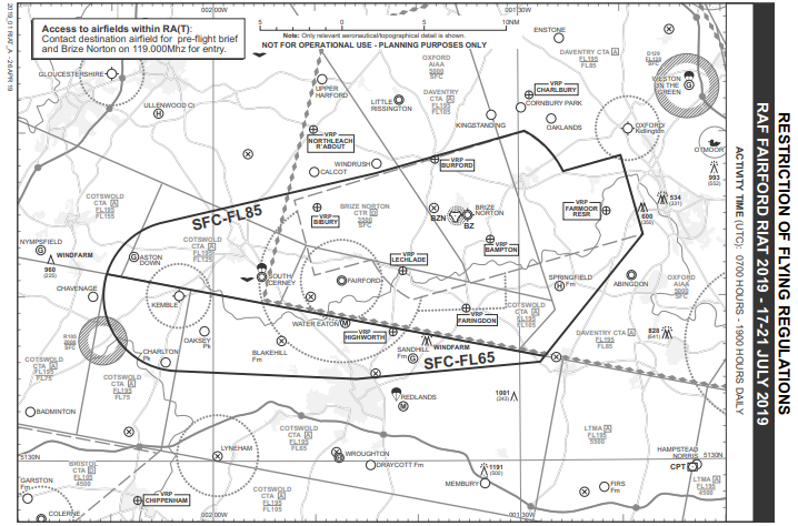
FIGURE 4: AIC M064/2019 CHART EXTRACT
As all RA(T) will be notified by NOTAM, they should appear on Moving Map displays provided that the platform is connected to the internet at the time of planning provided the NOTAM has been issued at that time (a final check of the AIS Telephone Information Line just before you go flying will reduce the risk of not knowing about a RA(T)). FIGURE 5 shows how the RA(T) was depicted on a Moving Map for the Royal International Air Tattoo 2019. The benefits of the correct use of Moving Map technology when planning for, and undertaking, the flight cannot be underestimated.
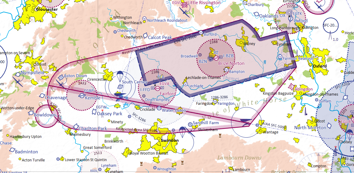
FIGURE 5: Royal International Air Tattoo RA(T) DEPICTION ON MOVING MAP
Emergency Restrictions of Flying
In the event of a disaster or major incident occurring on land or sea, within the boundaries of the UK Flight Information Regions, an Emergency Controlling Authority (ECA) may request that an Emergency Restriction of Flying (ERF) Regulations be made under the ANO2016. This is done to prohibit flight in the vicinity of the incident by aircraft not directly engaged in emergency action and thus ensures the safety of life and property, particularly for those working at the scene of the incident or engaged in Search and Rescue (SAR) action. Similar restrictions might also be necessary in the case of an emergency not classed as a disaster or major incident. In 2019, 14 ERF were established for incidents ranging from terror events to the finding of unexploded World War II munitions.
When ERF Regulations have been brought into force, the ECA is the only authority which may grant permission for aircraft to be flown within the notified airspace. Subject to overriding considerations of safety, flights by aircraft directly associated with the emergency action will be given priority over those seeking to overfly the area for any other reason.
Due to the nature of these restrictions, the means of notification are much more limited; a J series NOTAM (FIGURE 6) will be immediately issued but this serves only to notify pilots in the pre-flight planning phase and Air Navigation Service Providers.
FIGURE 6: J Series NOTAM
To cascade this information, the Distress and Diversion (D&D) cell at Swanwick Centre will broadcast a sécurité message on the aircraft emergency frequencies (GUARD) of 121.500MHz and 243.000MHz; air traffic service units close to the area will also advise pilots of aircraft on frequency.
How to Avoid the Risk of Infringing Airspace
The following points have been drawn up through analysis of recent airspace infringement of restricted airspace:
The Airspace & Safety Initiative website provides extensive advice on how to avoid the risk of infringing airspace.
Always use a Moving Map as part of your pre-flight route planning and in-flight to display the most ‘up-to-date’ airspace situation. Ensure that your device is connected to the internet when planning your flight.
In 2017, a pilot dispensed with their moving map when flying close to an air display; the subsequent RA(T) infringement resulted in an airprox with a jet positioning for its display.
In 2018, a pilot failed to connect their tablet device to the internet when planning/briefing for their flight and was unaware of a RA(T); the subsequent RA(T) infringement resulted in an airprox with a large transport aircraft practising its display.
Plan every flight in detail. Once you formulate your plan, consider a Plan B.
Apply Threat and Error Management in your planning. Threat & Error Management
Always call the NATS AIS Telephone Information Line prior to your flight (including each individual flight on a ‘multi-sector’ day’s flying). This will not only provide you with information on planned RA(T) but also on any ERF that may have been established since your last briefing. The information on this telephone line will not be sufficient to use solely as briefing material but will form the starting point to conduct a NOTAM/AIC brief on the activity. Two numbers are available as follows:
- 08085-354802; or
- +44(0)1489-887515.
Always carry out a NOTAM brief prior to EVERY flight no matter how short or local your flight is anticipated to be.
When able, it is recommended that you ‘Take 2’ around or over restricted airspace. In any case, when flying in the vicinity of such airspace structures, keep a good look out for other traffic and, for air display RA(T), beware aircraft entering, or holding to enter, or exiting the RA(T). TAKE2
Previous narratives in this series have encouraged pilots to obtain a service from ATC or use a Frequency Monitory Code (also known an FMC or Listening Squawk) when operating in the vicinity of controlled airspace to prevent airspace infringements or to enable their prompt resolution; by doing so (or by monitoring 121.500MHz on a second radio), you will also receive timely notifications of any ERF. Listening Squawks
Preventing infringements in the London Control Area
This infringement update is the twenty second in a series of narratives focusing on airspace infringements in the UK. This article is slightly different from our normal narratives and is focussed around the London Control Area (LTMA) rather than specific airfields or controlled airspace.
As we approach the summer bank holiday in England, Wales and Northern Ireland (apologies Scotland) you may be planning to fly further away from your normal area over the extended holiday weekend. Even if you’re not, perhaps this is a timely reminder of the infringement risk when flying under or close to the London TMA. For those not familiar with the airspace it comprises 24 different areas across a volume of airspace extending approximately 100NM from West to East and, in some areas 90NM from North to South. It encompasses the south east of England from east of the Isle of Wight turning north just to the west of Dover, passing Southend, to the northeast of Clacton before turning west passing south of Cambridge towards Milton Keynes before turning south to the east of Oxford, east of Southampton and back to the Isle of Wight. The area overlays international airports, multiple civil and military aerodromes and private landing sites serving all aspects of aviation. The LTMA is Class A airspace with the lowest base in places as low as 2,500 feet but the base levels rise further away from the centre and provides contiguous controlled airspace to the various Class D CTRs and CTAs for the London airports.
The areas are notified in the UK AIP in the En-route 2.1 (ENR2.1) section relating to Air Traffic Services Airspace and in the chart at ENR 6.42 (Figure 1 and 2). They are depicted on the 1:250,000 and 1:500,000 VFR charts, as per the extract and examples shown in Figure 2.
It is important to remember that the vertical limit of the 1:250,000 VFR chart is 5,000 feet so any TMA area with a base of 5,500 feet will not be depicted.
Figure 1 London TMA
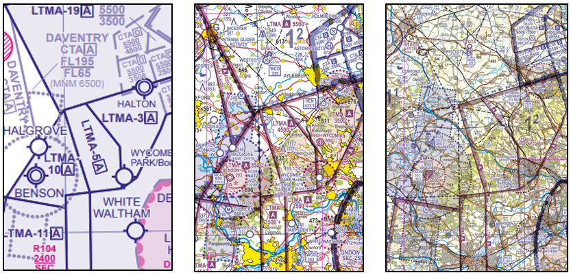
Figure 2 London TMA
In 2019 there were 279 reported infringements of the LTMA. An infringement of the TMA requires the ATCO to achieve 3NM or 3,000 feet separation from the unknown infringing aircraft and invariably requires the issuing of ‘safety intervention measures’ such as avoiding action to known traffic to achieve separation. An infringement of the TMA creates a significant safety risk to other pilots and considerable disruption to traffic with the associated increase in workload of pilots and ATCOs due to the traffic density at the various airports.At first glance, the chart of the area looks complicated but careful planning before the flight, including formulating a ‘Plan B’ option, can assist with reducing the workload during the flight and the chance of an airspace infringement from occurring. ‘Plan B’ should be an alternative route around controlled airspace when ‘Plan A’ is denied due to traffic density or when the weather requires a track diversion. We have already encountered several hot summer days with CBs bubbling away; flying through this thermic and turbulent air can quickly result in an infringement of the TMA or be a contributory factor to such an event. The ‘Plan B’ option is always a good ‘Error management’ technique when identifying the risks of your planned route as part of your Threat & Error Management.
Hot-spots
There are certain areas where infringements occur more often than others. A 5NM radius of the following areas are a general guide as to identified ‘hot-spots’ in respect of the TMA. Some of these infringements also result in infringements of adjacent CTAs.
| Location | Base of LTMA | Risk/Effect of Infringement |
| BNN – BPK – LAM | 2,500 feet | Infringements can affect Heathrow, Luton and Stansted traffic. |
| WOD | 2,500 feet, west of WOD 3,500 feet | Infringements can affect Heathrow traffic |
| 3NM North of BKY and north of Stansted and Luton CTA | 4,500 feet | Infringements can affect Luton and Stansted traffic |
| MID – MAY – DET | 2,500 feet although the levels change between MAY and DET | Infringements can affect Gatwick traffic |
Tips to avoid the Class A LTMA
Complete Comprehensive Pre-flight Planning
If you intend landing at an aerodrome under the TMA, a CTA or close to a CTR boundary, ensure you have briefed the local procedures; don’t assume that just because you went there last year nothing has changed. Those aerodromes with an ATZ that lay partly within a CTR have a Local Flying Area (LFA) agreement with the relevant controlling authority for the airspace (examples are Denham, Fairoaks, White Waltham and Redhill). It is vital that you follow the published procedures; LFA are not depicted on the VFR charts. Every year infringements are reported when pilots fail to follow the agreed procedures, either by track, altitude or both and infringe the adjacent airspace (CTR) which can easily lead onto an infringement of the TMA; in the 3 years from July 2017 to July 2020 there were almost 70 infringements of the London CTR through non-compliance with published LFA procedures.
A further example requiring detailed flight planning is the controlled airspace around Farnborough, introduced less than a month before the COVID-19 lockdown. You may have read the AICs and publicity material last winter, but have you refreshed your understanding of the airspace boundaries and Class E procedures? This is covered in a detailed narrative (number 10) on this page: Local area information
GPS Moving Maps and Alerts
The benefit of such technology cannot be over emphasised but in many infringements, it has been found that a contributory factor in the event was the deselecting of alerts or not checking the vertical filter settings are set correctly for the planned route. In one occurrence, a pilot reported that the GPS failed on a flight inbound to Elstree from the southwest; in a few seconds, their workload increasing dramatically; a paper chart was immediately available which helped enormously. By plotting the route on a paper chart, you have a perfect contingency in place when the ever-present Threat of a Moving Map failing in flight actually occurs.
Plan Climb and Descent Points
A significant number of infringements occur when pilots start their climb too early from the boundary of different LTMA areas or start their descent too late when approaching areas with a lower base. Why not add a waypoint to your route plan in your Moving Map/on your paper chart that coincides with where it is safe to start a climb or where you need to start your descent to remain under that lower LTMA area ahead of you?
There have also been occurrences when aircraft have left CAS in the descent, following a pilot request, for the pilot to subsequently infringe CAS further along its track to the destination.
Once an aircraft has left CAS a new clearance is required to re-join any further CAS further along its route. Every year reports are received where pilots are unaware of this requirement or have lost situational awareness of their position in relation to adjacent CAS boundaries. A recent airspace infringement resulted when a pilot flying IFR in the Class A Worthing CTA descended out of the airspace and routed under the LTMA areas 8 and 20 only to re-enter LTMA area 2 when positioning to make an approach to Shoreham (Figure 3). The pilot openly reported that:
Having been “cleared to leave controlled airspace by descent,” I carried out a constant descent towards my next waypoint. During this descent, I became unaware that the aircraft had left controlled airspace and my current flight path would then result in me re-entering Class A airspace. This event has highlighted the importance of thoroughly studying the airspace structure along the intended route and also to understand and comply with the exact ATC clearance.
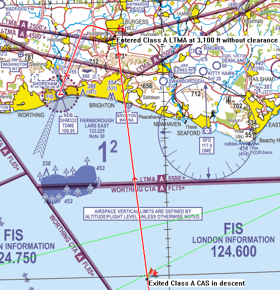
Figure 3: Re-entering LTMA area 2 when positioning to make an approach to Shoreham
Actively Plan to Remain Clear of the Controlled Airspace – ‘TAKE 2’
In 2017, an active GA pilot and member of a Local Airspace Infringement Team introduced the concept of remaining clear of controlled airspace by 200 feet below the case of controlled airspace (or above a CTR/CTA with Class G above, or above an ATZ or Restricted Prohibited or Danger Areas) or 2nm laterally to help pilots avoid infringing airspace. His simple yet effective idea was supported by safety partners across the aviation community and so the TAKE2 concept was born.
‘Take 2’ can be difficult in some locations around the London area. However, the principle of providing a margin for unexpected errors in the vicinity of CTR/CTA boundaries should not be forgotten just because ‘Taking 2’ might not be possible areas all the time.
In the first month after all COVID-19 related limitations on General Aviation flying were removed, there were almost 30 reported infringements of the TMA. Of these, 15 involved an incursion of 300 feet or less. If the pilots involved had adopted the ‘Take 2’ principle perhaps some of the infringements could have been prevented.
Every year infringement reports are received relating to instructional flights and air-test/maintenance flights. In each of the past 3 years, approximately 1 in 6 infringements occur during instructional flights. With the numerous airspace boundaries and changing levels it is critical that the location for these flights is carefully assessed. As the name says the forecast upper wind is a forecast wind and it’s easy to inadvertently drift into the TMA whilst concentrating on a specific exercise or task assuming the upper wind is as per the forecast. Closer monitoring of an aircraft’s position and track during such flights could eliminate these infringements; this is made all the simpler by the Flight Instructor actively using Moving Map technology both in planning and executing the training flight.
Pressure Setting
The London QNH or the QNH from the aerodrome you’re receiving a service from must be used. If not receiving a service, a QNH can be easy obtained by listening to the appropriate frequency or from the ATIS of the closest airport. Pilots should not be operating on a Regional Pressure Setting when operating under the TMA. There is only a small part of the TMA where the notified base is a Flight Level (FL), so planning when to adjust to a FL and standard pressure setting should be noted.
Frequency Monitor Codes (FMC) ‘Listening Squawks’
The pre-flight planning should include the applicable FMCs and associated frequency for the route. These are available in the UK AIP at ENR1.6 (2.2.5), on this ASI Squawk card and summarised below.
Figure 4 LTMA Listening squawks
| Unit | FMC | Monitoring Freq |
| Luton Radar | 0013 | 129.550 MHz |
| Stansted (Essex Radar) | 7013 | 120.625 MHz |
| Southend Approach | 5050 | 130.780 MHz |
| Gatwick Director | 7012 | 126.825 MHz |
| Thames Director | 0012 | 132.700 MHz |
| Farnborough Radar | 4572 | 125.250 MHz |
| Southampton (Solent Radar) | 7011 | 120.230 MHz |
| Oxford Approach | 4517 | 125.090 MHz |
UK Flight Information Services (UK FIS)
Obtaining one of the Flight Information Services is an alternative to using an FMC, even if only for a short duration, if the flight is likely to be operating close to an airspace boundary which you are unfamiliar with. London Information is not permitted to provide a surveillance service so when operating in this busy area the safer option is to obtain a service from the most appropriate unit. There are numerous units which provide a service depending upon your location and route.
If you are lost or uncertain of your position, don’t delay in seeking assistance, squawk 0030 (FIR Lost) and call Distress and Diversion (D&D) on 121.500MHz.
For clarification Thames Radar provide a service to London City and Biggin Hill and the 0012 FMC may be used when flying in the vicinity of London City and London Heathrow and operating outside of the London CTR/London City CTR/CTA.
NAVAID Tracking to/from the TMA
Tracking towards the TMA boundary with the base levels gradually decreasing needs close monitoring and in reverse climbing under the TMA when tracking away. Tracking ‘navaids’ may provide assurance of being ‘on-track’ but it will not provide vertical guidance for remaining below controlled airspace.
Providing a “Friendly Information Service”
This infringement update is the twenty third in a series of narratives focusing on airspace infringements in the UK. This article highlights the service that London and Scottish Information provide and the assistance available to help you avoid infringing airspace.
It has been said you can obtain an idea of weather conditions across the UK by listening to the London or Scottish Information frequencies during the day, especially in the summer; the busier the frequency the nicer the weather. Although you are probably more familiar with the Flight Information Service Officer (FISO) at your local aerodrome the FISO at London or Scottish Information provide an invaluable service and provide a range of information if you ever need it.
The FISOs at the NATS control centres provide a ‘Basic’ and ‘Alerting’ service for General Aviation (GA), military and commercial aircraft operating outside Controlled Airspace (CAS) within the UK Flight Information Regions (FIRs). You can always obtain information without requesting a ‘Basic Service’.
London FISOs based at NATS’ Swanwick Centre provide a service to the aircraft within the London FIR below FL195, 24 hours a day.
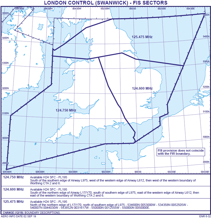
London Control (Swanick) FIS Sectors
The Scottish FISOs based at Prestwick Centre are responsible for the Scottish FIR between 08:00 -20:00, local time, up to FL55. Outside these times and levels, the service is provided by air traffic controllers on various sectors.
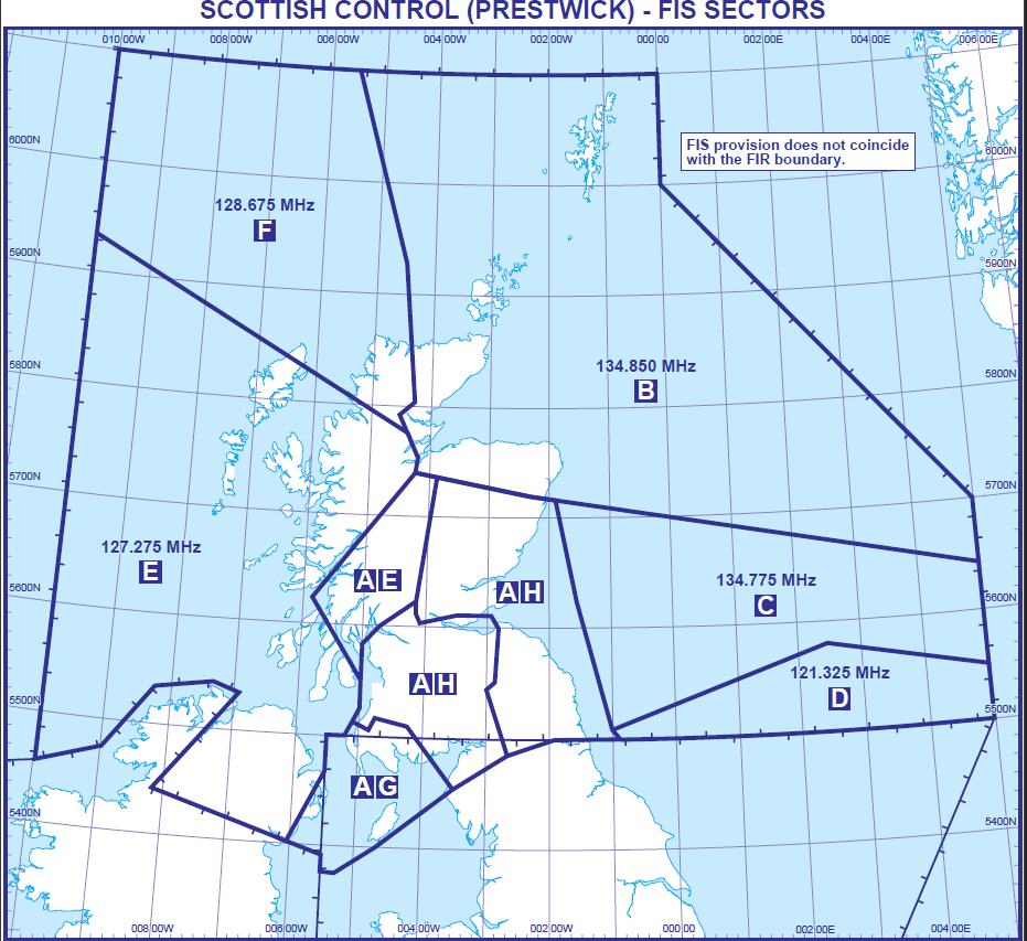
Scottish Control (Prestwick) FIS Sectors
| Area | Frequency | Times & Coordinates | Levels |
| A | 119.875 MHz | 0800-2000 (One hour earlier in Summer) | SFC to blo FL55 |
| B | 134.850 MHz | H24 | SFC- FL245 |
| C | 134.775 MHz | H24 | SFC- FL245 |
| D | 121.325MHz | H24 | SFC- FL245 |
| E | 127.275 MHz | See UK AIP ENR 6-33. | See UK AIP ENR 6-33. |
| F | 128.675 MHz | H24 | SFC- FL245 |
| G | 123.775 MHz | H24
2000-0800 (One hour earlier in Summer) |
FL55-FL245
SFC-FL55 |
| H | 124.500 MHz | See UK AIP ENR 6-33. | See UK AIP ENR 6-33. |
Although FISOs are not controllers they are highly trained and experienced. Under a ‘Basic Service’, a FISO’s role is to assist you in achieving a safe flight. The passing of executive instructions, headings or altitudes to fly is not permitted but providing information to assist you in achieving that safe flight is permitted. This could be anything from letting you know of the latest METAR or TAF, parachuting activity, Search and Rescue Operations (SAROPS), Temporary Danger Areas (TDA) or significant weather affecting your route. Some of this information may have changed since you completed your pre-flight planning and departed so obtaining the most up-to-date information is always wise if you believe the situation may have changed.
During the summer of 2020 many airfields had revised and reduced operating hours and declassified the relevant CAS when the aerodromes were closed. This information was notified via NOTAM, but this information was also available from the FISO. This is an example of when the FISO can be a useful source to obtain updated information and may have, and possibly continue to assist, in mitigating the risk of airspace infringements.
FISOs do not use radar-based surveillance to exercise positive control or offer advice to pilots but may monitor aircraft positions using a Flight Information Display (FID) although they rely on the information pilots give to help form a traffic ‘picture’ utilising a 1:500k VFR chart. The FISO have access to other information and documentation if required. Direct telephone lines to every adjoining London and Scottish control sector, and every major airfield, plus many of the minor airfields assists in obtaining information and co-ordination quickly. However, the FISO has no data to show the number of aircraft expected to establish contact and request a service. There is no traffic level prediction tool, just a weather forecast and a calendar of airfield events, a list of air shows and ‘fly ins’ to help to foresee those potentially busy times and areas.
When you first establish contact with the FISO and request a service from London or Scottish Information you will be asked for your callsign, aircraft type, position, altitude and routeing, and then asked to squawk ‘conspicuity 1177’ for London or ‘7401’ for Scottish. As a non-radar service, this squawk isn’t primarily for the benefit of the FISOs; it informs all the radar units across the London and Scottish FIR that you are talking to Flight Information.
Once the FISO has the aircraft details, the route can be checked for any possible issues with active Danger Areas (DA). If one is identified as active the pilot can be informed and the extent and level of its activity. This simple and easy process has prevented DA infringements.
The alternative of squawking 7000 or 2000 would mean the ATCO at a radar equipped unit is unable to contact the pilot as quickly compared to an aircraft displaying the FIR squawk. The use of a specific Frequency Monitor Code (FMC) is probably a better option than a FIR squawk but in those areas where the air traffic control unit does not have a specific FMC then obtaining a service from the FIR is an alternative option to the 7000/2000 transponder code. Alternatively, obtaining one of the Flight Information Services from the specific unit always remains an option. Subject to the FISO workload, it is possible request the FISO pre-note a unit of your intended route through the airspace if your workload is high or external factors are having an impact on flight safety.
As FISOs are not permitted to issue specific altitude or heading instructions, it can often be that pilots will be asked to transfer frequency to specific frequency for a controller to be able to identify the aircraft and provide specific instructions or information. This is more likely in the pre- or post-infringement phase of a flight. By obtaining a service from London or Scottish Information and flying close to a controlled airspace boundary, the relevant radar unit can quickly contact the FISO if there is likelihood of an infringement or if an infringement has occurred. Although it may be disconcerting that you have been asked to change frequency, the key aspect is safety; not only your safety but the safety of other pilots and aircraft.
Unplanned flight diversion, unexpected change in plan or a track deviation can create potential ‘Threats’ to the risk of an airspace infringement. Every year the infringement statistics include the ‘unexpected’ aspect as a partial causal factor in the infringement. The extent of the ‘Threat’ will vary depending on your experience, knowledge and skill in maintaining situational awareness. In terms of ‘Threat and Error Management’ the FISO, like any ATCO, can assist in the ‘Error Management’ aspect by assisting (some may see it as an additional pilot) in obtaining information or co-ordinating diversions to airfields if necessary.
As many infringements of airspace are vertical incursions, the use of the correct pressure setting is important. Although FISOs can obtain the correct pressure setting in your area, it is easier to request it from the local airfield frequency or obtain it from an Automatic Terminal Information Service (ATIS) frequency. The use of the Regional Pressure Setting (RPS) beneath CTA has resulted in numerous infringements as its use will result the level displayed on the altimeter lower than the aircraft’s actual level resulting in a vertical infringement. If you are flying close to controlled airspace and in receipt of a ‘Basic Service’ from London or Scottish Information, consider which frequency/who best to get a service from to help prevent an airspace infringement. Make this aspect of your flight an important part of your pre-flight planning.
Maintaining situational awareness is essential and although there is a benefit of receiving a service from the FISO the pilot is responsible for avoiding aerodrome traffic zones (ATZ) whilst en-route. Consideration should be given to leaving the FIS frequency, and advising the FISO of such, to change to the relevant approach unit if your track will pass through the extended runway centreline of those airfields with instrument approach procedures outside controlled airspace.
So, the next time you go flying consider whether obtaining a service from London or Scottish Information is an option or whether any information you need or updated could be available from your friendly Flight Information Service Officers.
Preventing infringements of Luton Controlled Airspace
This infringement update is the twenty fourth in a series of narratives focusing on airspace infringements in the UK. This article highlights the risk of airspace infringements around Luton Control Areas (CTA) and Control Zone (CTR) and provides guidance and suggestions to assist in reducing the risk.
In 2019, there were a total of 44 airspace infringements of Luton Controlled airspace; 23 infringements of the Luton CTR and 21 of the Luton CTA. In the first 8 months of 2020, including the period of the COVID-19 restrictions on General Aviation, there have been 24 infringements (15 of the CTR and 9 of the CTA).
Any infringement within the controlled airspace requires the Luton radar controllers to establish a minimum of 3NM lateral or, when altitude information is available, 3,000 feet vertical separation which results in an increase in workload for pilots and controllers as well as delays to arriving and departing aircraft. The impact of an infringing aircraft will depend upon the location and can impact on both Stansted and Luton airports simultaneously.
The Class D Luton CTR extends from the surface to 3,500 feet with the nine parts of Luton Class D CTA ranging from 2,500 feet (at the lowest part) to 5,500 feet (at its highest). The London Terminal Control Area (TMA) is contiguous with the CTA in some areas. VFR flights in the Luton CTR/CTA will be given routeing instructions and/or altitude restrictions in order to integrate VFR flights with other traffic; a 1.5NM wide VFR lane is also depicted on the 1:500K VFR chart. Pilots should anticipate clearance and routeing instructions via Entry/Exit Lanes and as such should be planned for transits of the CTR; prior to entering controlled airspace, as clearance, from Luton radar, is required to transit this lane. (FIGURES 1 and 2)
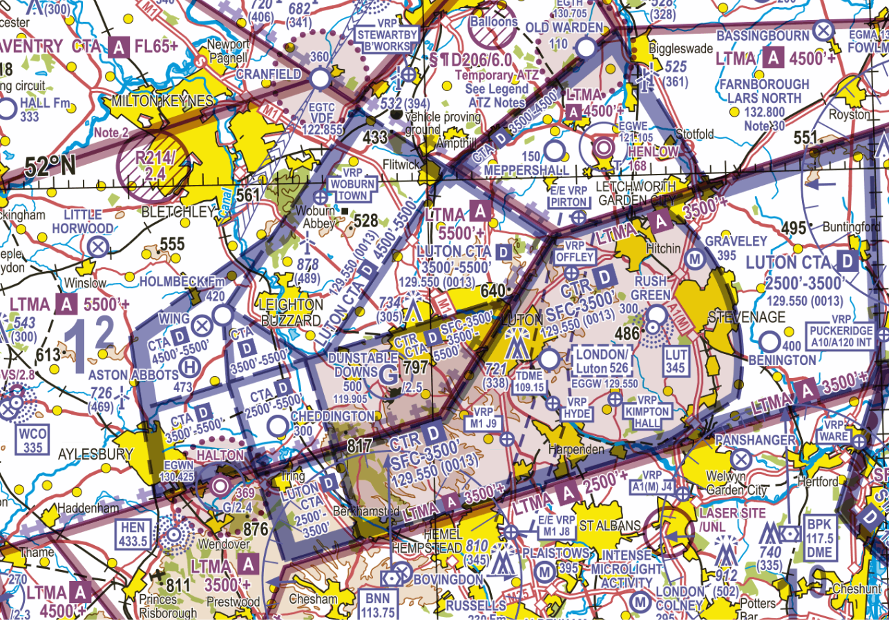
FIGURE 1
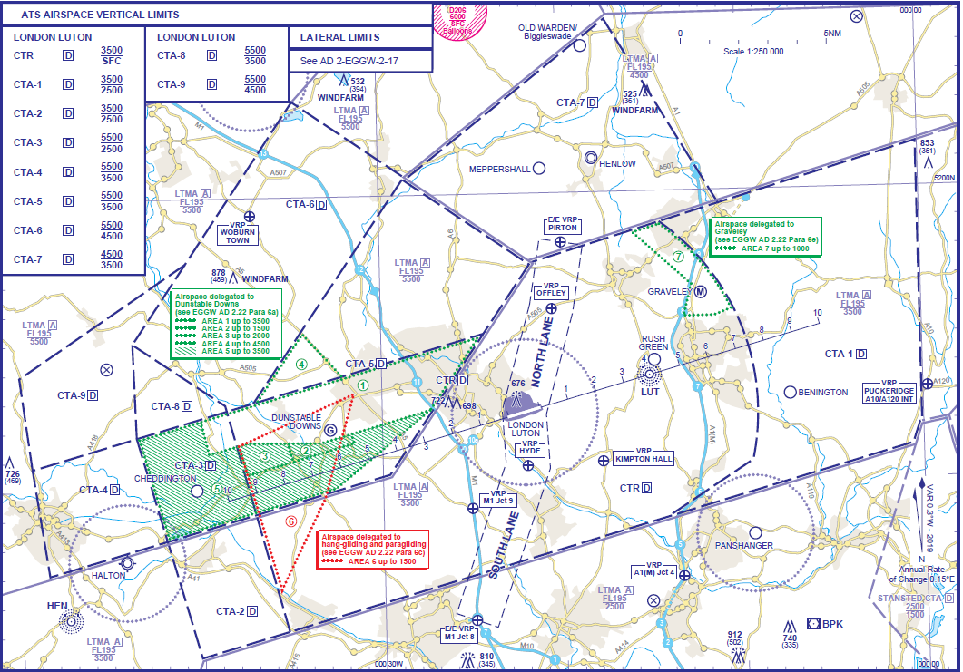
FIGURE 2
The number of aerodromes (including disused ones) and those with ATZ, privates landing sites, navigational aids and Visual Reference Points marked on the chart can make the airspace appear complex, before the various airspace classifications, levels, frequencies and Frequency Monitoring Codes (FMC) are included. Identifying the ‘Threats’ in the planning stage for flights in this area will assist with solutions to ensure infringements do not occur.
Visual Reference Points
Seven Visual Reference Points (VRP) are published to support the planning of flights through the CTR via the Entry & Exit Lane (known as North & South Lane) as follows:
a. The village of Pirton is on the edge of the CTR and lies at the northern edge of the North Lane. The VRP is the church in the village (FIGURE 3).
b. The VRP at Offley lays on the A505 west of Hitchin and 3.5NM northeast of the airport. (FIGURE 3). The VRP is the bridge over the A505. This VRP is often used as a clearance limit as part of the VFR CTR transit clearance as a holding area to establish visual contact with aircraft to allow integration with at Luton Airport.
FIGURE 3 Pirton and Offley VRPs
c. The VRP at Hyde lays less than 2NM south of the airport. The VRP is the railway bridge at East Hyde and is easily identifiable to the northeast of the sewage farm/water treatment works. (FIGURE 4)
d. Kimpton Hall VRP lays to the south of the village of Kimpton and 3.25NM southeast of the airport. (FIGURE 4).
The VRPs at Hyde and Kimpton Hall are often used as a clearance limit as part of the VFR CTR transit clearance as a holding area to establish visual contact with aircraft to allow integration with traffic at Luton Airport.
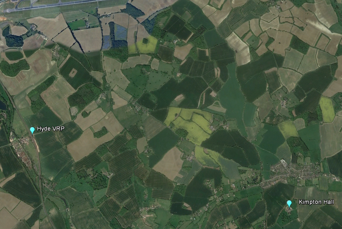
FIGURE 4 Hyde and Kempton Hall VRPs
e. The final 3 VRPs all relate to motorway Junctions and are shown in FIGURE 5. One, the M1 Junction 9 lies inside the CTR and 3.7nm southwest of the airport; it is the figure of 8 junction on the straight piece of motorway mod way between Hemel Hempstead and Luton. The other 2, M1 Junction 8 and A1(M) Junction 4 both lie outside the CTR and are easily identifiable point to set as your clearance limit if you are not in receipt of a clearance to enter controlled airspace.
M1 Junction 8 is to the east of Hemel Hempstead and is the entry point for the south lane. The final VRP at A1(M) Junction 4 lays between Hatfield and Welwyn Garden City and is the confluence of several major roads.
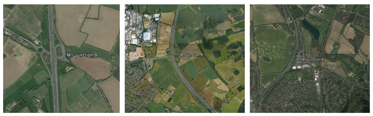
FIGURE 5 M1 Junction 9, M1 Junction 8, A1(M) Junction 4 VRPs
Infringements of the Luton CTR and CTA-2
The area north of Bovingdon VOR (BNN) is an area where infringements of the Luton CTR and CTA-2 (base 2,500 feet) have occurred (FIGURE 6), mainly by instructors who have become distracted from monitoring their height or exact position when teaching. Infringements of the London Control Area (LTMA) where the base is 2,500 feet immediately overhead BNN have also been reported. Even with restrictions on GA flying in the first half the year there were 6 infringements in the first 6 months of 2020 in these areas.
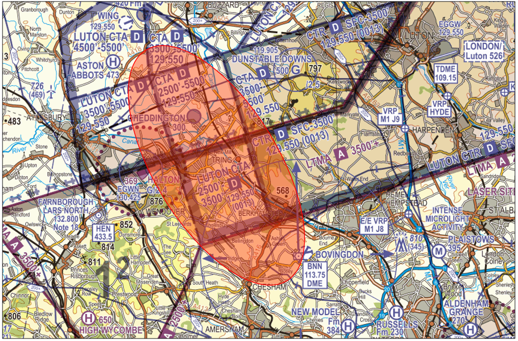
FIGURE 6
Westbound/Eastbound to the South of the Luton CTR
The use of BNN and BPK can assist with remaining south of the CTR but if planning by landmarks or features reference to Chesham (Southwest of BNN) – Hemel Hempstead – St. Albans – Welwyn Garden City is an option.
In the area under to the west of Luton CTR there were 9 infringements within CTA-2/3/4/8/9 within the first 6 months of 2020.
Southbound/Northbound to the West of the Luton CTR
For those who wish to route in the gap between the Halton ATZ (active 0900-2000 or SS + 15 (1 hr earlier in Summer)) and the Luton CTR it is essential that pilots must plan and identify prominent features to assist in the ‘Threat & Error Management’ of navigational errors.
If routing southbound from Milton Keynes following the railway line to Leighton Buzzard and then towards Tring lakes to the east of Wilstone Reservoir will keep pilots out of the Halton ATZ and west of the Luton CTR. Although the Milton Keynes to Tring railway line/Grand Union Canal/A4251 junction is suggested it needs to be highlighted that at Tring all these 3-line features will eventually lead you into the south western corner of the Luton CTR. With ‘Error Management’ in mind the best solution would be to track towards Chesham after Tring. (FIGURE 7)
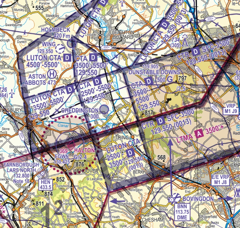
FIGURE 7
Southbound/Northbound to the East of the Luton CTR
CTA-1 (base 2,500 feet) lies to the east of the Luton CTR; the use of BPK and Barkway (BKY) can be useful if radio navigation aids are required to assist with remaining east of the CTR. Alternatively, planning a route with reference to Hertford – east of Stevenage – Letchworth Garden City/Baldock at the end of the A1(M) is an option to be considered in the planning phase. (FIGURE 8) Similarly, the area north of Brookman’s Park (BPK) can also result in an infringement of the TMA, Luton CTA-1 or parts of the Stansted CTR and CTA.
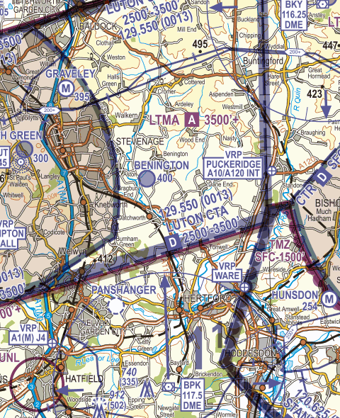
FIGURE 8
Flying North of the Luton CTR
The M1 remains an easy feature to identify from the air but with so many junctions close to CTA boundaries (FIGURE 9), it is vital to recognise where airspace steps down towards the Luton CTR. The boundary of the CTA-6 where the base is 4,500 feet (just north of junction 13, with a railway line passing nearby) southeast of Milton Keynes, south of Cranfield airport should be recorded in any flight plan and identified as a potential ‘Threat’ in the planning stage. The A421 is a good visual boundary feature as it routes towards Bedford.
Similarly, CTA-5 boundary base reduces to 3500 feet near junction 12 for Toddington. However, pilots often confuse the junction with Toddington Services which is one mile further south or the ‘dumbbell’ junction with the A5 at Houghton Regis, north of Dunstable and a mile north of the Luton CTR boundary.
Tracking north of the CTR can be planned by reference to Royston – north of Letchworth Garden City – Toddington Services on the M1 – Leighton Buzzard.
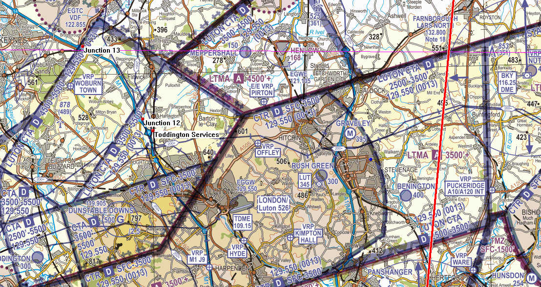
FIGURE 9
| When operating west of the red line the Luton FMC (0013) should be used including monitoring of Luton Radar on 129.550MHz.
When operating east of the red line the Stansted FMC (7013) should be used including monitoring of Essex Radar on 120.625MHz. |
With all these suggested routes, if you are not in receipt of an air traffic service, good airmanship is to squawk 0013 and monitor the Luton Radar frequency of 129.550MHz rather than squawking 7000 or 2000. However, it is important in your pre-flight planning to know where the boundary lies between using the Luton FMC of 0013 and that for Stansted of 7013 and monitoring the Essex Radar frequency of 120.625MHz. The chart in the UK AIP at ENR6.80 and in AIC YELLOW 006/2020 shows that when crossing the line between Royston and BPK you should be changing FMC and frequencies depending on your direction of flight; failure to do so will result on relays in resolving airspace infringements. There have been recent occurrences where pilots have infringed the Stansted CTR/CTA to the east of Ware, tracking northeast or southeast, but still using the Luton FMC.
Preventing an airspace infringement
The Airspace & Safety Initiative website provides extensive advice on how to avoid the risk of infringing airspace. Pilots are strongly encouraged to:
Use a Moving Map which will provide a profile along your planned route showing the controlled airspace boundary. When flying in proximity to Luton controlled airspace, and if able to, Take 2.
Obtain a service from Farnborough on LARS North: 132.800MHz.
Use a Frequency Monitor Code (FMC). If you do not want to obtain a service from ATC use a FMC appropriate to the direction of flight (rather than squawking 7000/2000). FMCs have proven to prevent infringements and reduce the severity of such occurrences.
| Farnborough LARS North | 132.800MHz | |
| Luton Radar | 129.550MHz | FMC: 0013 |
| Essex Radar (Stansted) | 120.625MHz | FMC: 7013 |
Use the correct QNH. Obtain the Luton QNH from the ATIS (120.580MHz) or monitor the Luton frequency (129.550MHz). The Luton ATIS is also available on 01582 395225 if the METAR is required prior to departing, especially from a private site close to the CTR or under the Luton CTAs.
Make a Detailed Plan. Build in your climb and descent points when planning your route. Know what VRPs look like and what airspace lies above them or close by.
If necessary, request a clearance. If for any reason a climb is required above the base of the CTA, then a clearance must be obtained from Luton Radar before climbing. If in doubt, of the base of CAS or the boundary contact Luton Radar for assistance.
This infringement narrative is an update to that issued as the UK emerged from its national COVID-19 associated lockdowns and is focusing on the identified infringement hot-spot in the UK in the vicinity of Southampton Airport and The Solent.
In 2022 there were 118 reported airspace infringements of the Southampton CTR/Solent CTA. To 21 June 2023, the number of reported airspace infringements this year has reached 51 and week on week infringements continue to occur.
Infringement hot-spots in the Solent and Southampton area
Air Traffic Control and Solent Radar
The primary function of Southampton Air Traffic Control (ATC) is to provide a service to aircraft arriving to and departing from Southampton International Airport (and some Bournemouth Airport associated traffic), as well as those aircraft that wish to enter, operate in or transit through the Southampton/Solent controlled airspace.
Solent Radar is also responsible, by virtue of delegated airspace, for part of some lower levels of the London Terminal Control Area (LTMA) (those that lie immediately above the Solent CTA), together with providing a function to certain Farnborough departures. This creates a busy environment, where extensive co-ordination takes place beyond what may be apparent by just listening to the radio.
Commercial Air Transport aircraft can be operating as low as 500 feet above the base of controlled airspace. The complexities associated with the diverse controlling and airspace management/coordination tasks means that any airspace infringement may not only compromise safety but have an impact on the operations at three airports.
An infringing aircraft that is not radar identified by Solent Radar becomes unknown traffic; a separation standard of 3NM laterally or 3,000 feet vertically is required between that aircraft and IFR aircraft operating within Southampton/Solent controlled airspace. All infringements pose a significant risk to safety and controller’s workload.
Solent airspace
The Solent airspace comprises the Southampton Control Zone (CTR, surface to 2,000 feet AMSL) and eight Solent Control Areas (CTA) as depicted in Figure 1. All airspace is Class D.
| Southampton CTR | Surface – 2000 feet AMSL |
| Solent CTA-1 | 1,500 feet AMSL – 5,500 feet AMSL |
| Solent CTA-2 | 2,000 feet AMSL – 5,500 feet AMSL
Note: Extends over Southampton and Bournemouth CTR |
| Solent CTA-3 | 2,000 feet AMSL – 5,500 feet AMSL |
| Solent CTA-4 | 2,500 feet AMSL – 5,500 feet AMSL |
| Solent CTA-5 | 2,500 feet AMSL – 5,500 feet AMSL |
| Solent CTA-6 | 3,000 feet AMSL – 5,500 feet AMSL |
| Solent CTA-7 | 3,500 feet AMSL – 5,500 feet AMSL |
| Solent CTA-8 | 3,500 feet AMSL – 5,500 feet AMSL |
Known infringement hot-spots
There are three areas (as depicted in figure 1 by the red shapes a,b and c) in which most airspace infringements occur.
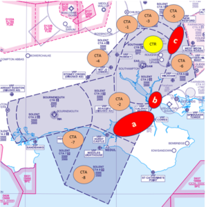
Figure 1 correct as at AIRAC 06/2023
a – Solent CTA 2 over The Solent and the north coast of the Isle of Wight
When flying over the water, pilots aim to fly as high as possible and then inadvertently exceed the 2,000 feet AMSL base. This may be compounded by flying on the incorrect altimeter setting where the Southampton QNH should be used. The correct Southampton QNH should be used and can be obtained via several sources such as the Southampton ATIS (130.880 MHz), when monitoring 120.230 MHz when using the Solent FMC; VOLMET on 128.600 MHz (London VOLMET) or simply by asking Solent Radar on 120.230 MHz.
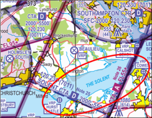
Figure 2 Hot-spot a – Solent CTA 2 (AIRAC 06/2023)
b – Southampton CTR in the vicinity of the Calshot Beach Visual Reference Point (VRP) or to the west of the Lee-on-Solent Aerodrome Traffic Zone
Most of these infringements involve aircraft arriving or departing from Lee-on-Solent Aerodrome (EGHF) or when flying a wider visual circuit/delaying action in the visual circuit at Lee-on-Solent to sequence high-performance aircraft behind microlights/slower aircraft. The CAA is noting a rising number of occurrences when pilots are operating on the Lee-on-Solent conspicuity code of 4306. This code should only be displayed when 4306 prior to joining or leaving the visual circuit. When inbound, as a guide, this should be done at any of the following locations: Calshot, Cowes, Spinnaker Tower or Wickham. Outside of these areas, and subject to retaining situational awareness on other Lee-on-Solent traffic, pilots are encouraged to use the Solent FMC as soon as possible.
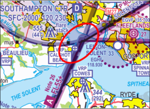
Figure 3 Hot spot b – Solent CTR (AIRAC 06/2023)
c – Solent CTA-3/CTA-5 in the vicinity of the New Alresford VRP
The VRP is located at 510519.70N 0010859.10W which in underneath CTA-5 (base 2,500 feet AMSL) and is the point where the B3047 road crosses the railway line (colloquially known as The Watercress Line) to the east of New Alresford town. This is a common VRP used for navigation. Since the expansion in the use of VFR Moving Maps, another point that has become a commonly used turning point is the IFR waypoint called HANKY; this point lies 0.3NM northeast of the boundary of CTA-5 and is not associated with any geographical VFR navigation feature. Infringements in this area frequently result from pilots entering the CTAs:
- laterally due to deviating from their planned route which is so close to the edge of controlled airspace because they are routing over the New Alresford VRP or IFR way point at HANKY.
- laterally when flying VFR via HANKY and experiencing a VFR Moving Map failure leading to a loss of situational awareness as to their position.
- vertically when flying at or slightly below the base of controlled airspace and then inadvertently exceeding the base altitude. This may be compounded by flying on the incorrect altimeter setting when the Southampton QNH should be used.
It is important to ensure that when flying VFR, you do not rely on IFR waypoints but instead use appropriate ground features along your route to increase your situational awareness if your electronic device should fail. Again the correct Southampton QNH should be used and can be obtained via several sources such as the Southampton ATIS (130.880 MHz), when monitoring 120.230 MHz when using the Solent FMC; VOLMET on 128.600 MHz (London VOLMET) or simply by asking Solent Radar on 120.230 MHz.
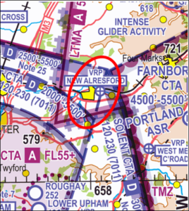
Figure 4 Hot spot c – Solent CTA-3 CTA-5 (AIRAC 06/2023)
Preventing an airspace infringement
The Airspace & Safety Initiative website provides extensive advice on how to avoid the risk of infringing airspace. Pilots are strongly encouraged to:
Take 2
An initiative established through the Local Airspace Infringement Teams (LAIT) is to TAKE2. By remaining at least 200 feet below the base, or 2NM horizontally away from the edge of a block of controlled airspace then, any inadvertent deviation from level flight or planned course could be identified in sufficient time to prevent an airspace infringement. As mentioned in the introduction, it is especially important when flying ‘under’ the Solent CTA‐2 – i.e. below 2,000 feet. A radar controller can usually see traffic operating beneath controlled airspace while controlling inbound traffic to Southampton (and in principle in this area, Bournemouth too) and must expect such aircraft to remain outside the CTA‐2. Any vertical deviation that results in an aircraft entering the CTA‐2 without a clearance, can immediately cause a loss of separation with an aircraft already established within the airspace. This quickly becomes a significant safety event employing avoiding action, creating a highly elevated workload with yet greater risk, and resulting in a substantial amount of reporting action and investigation that a loss of separation entails. An aircraft just ‘popping up for a moment’ can easily be as significant as a horizontal infringement from an ATC perspective.
Use the appropriate FMC (Listening Squawk) and listen out
The airspace below the CTA‐2 is Class G airspace (uncontrolled). There is no requirement to receive a service from either Bournemouth ATC (to the west) or Southampton ATC (the controlling authority).
However, the introduction of the Frequency Monitoring Code (7011 for Southampton/Solent Radar 120.230MHz, or 0011 for Bournemouth Radar 119.480MHz) enables ATC at those units to observe an aircraft that may be of potential conflict to their traffic inside controlled airspace and interrogate such an aircraft when appropriate.
The recommended area within which the Solent FMC should be used is depicted within the black lines in figure 5. The use of this FMC has been proven to prevent infringements and reduce the severity of such occurrences by enhancing the controllers’ and pilots’ situational awareness and creating a safer and more predictable situation than would otherwise prevail.
The agreed ‘demarcation’ line between the Solent and Bournemouth FMC is a line orientated northwest to southeast between Stoney Cross and Hurst Castle; to the west it is Bournemouth (0011/119.480MHz) and to the east is Solent Radar (7011/120.230MHz).
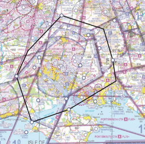
Figure 5 Recommended Solent FMC area (AIRAC 06/2023)
Obtain an Air Traffic Service (ATS) from a Lower Airspace Radar Service (LARS)
If you would prefer to obtain an ATS rather than use an FMC, then a LARS is provided by Farnborough Radar to the north and northeast of the Southampton CTR, by Boscombe Down to the north and northwest of the CTR, and by Bournemouth Radar to the west, southwest and south of the CTR. All services provided by LARS are in line with CAP 774 – UK Flight Information Services.
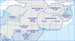
Figure 6 Extract from ENR 6-1 (LARS) AIRAC 06/23
Set the right QNH
The base of controlled airspace is determined by the local Southampton QNH, not the Portland RPS. A difference of 3‐4 hPa is not unusual and aircraft flying close to the base of controlled airspace can inadvertently infringe just by having the wrong (inappropriate) QNH selected.
If appropriate – request a clearance. If for any reason a climb is required above the base of 2,000 feet in CTA‐2, then a clearance must be obtained. Depending on a variety of factors, not least the runway in use and traffic situation at the time, this may well be available. By obtaining a clearance to enter controlled airspace when appropriate, ATC can control more effectively and ensure safety is maintained.
Always use a VFR Moving Map
There are many reasons why a pilot can lose situational awareness of their position that may then result in an airspace infringement. Whether flying recreationally or carrying out an instructional flight, the correct use of a Moving Map is known to reduce that risk and assist in increasing pilot capacity.
When flying a route that requires changes in altitude due to, for example, CTAs it is good practice to annotate on your chart climb and descent points that take into account the requirements of the airspace and should incorporate the ‘Take 2’ guidance; these points should then be noted on your PLOG and added as separate waypoints on your VFR Moving Map device to act as triggers.
The use of any equipment/technology carries its own set of Threats and Errors; the European General Aviation Safety Team, Safety Promotion Leaflet, Using Advanced Navigation Technology Safely offers advice and guidance in their use along with the CAA’s Safety Sense Leaflet 29 – VFR Moving Map Devices.
Preventing airspace infringements in the vicinity of the Channel Islands Controlled Airspace
Introduction
The Channel Islands controlled airspace is unusual as it sits within both the UK (London) and the French (Brest) Flight Information Regions (FIR).
As a result of multiple Airspace Infringements over the years, Jersey Air Traffic Control (ATC) has set up a Local Airspace Infringement Team (LAIT). The LAIT meetings involve adjacent French and UK airfields, Military operations, Coastguard, Fisheries and GA users. Jersey ATC is the controlling authority for Channel Islands Controlled Airspace.
An 11% portion of the Channel Islands Controlled Airspace to the north sits within the London FIR (EGTT) with ATS delegated to Jersey during published hours. The Class D Channel Islands Control Zone (CTR North) is established from SFC to FL80 and the Class A Channel Islands Terminal Control Area (TMA North) from FL80 to FL195. Some pilots may be confused by the dimensions of the Controlled Airspace, but it starts at 50N from surface between 2W and 3W.
To the west of 3W there is also a Class D Control Area (CTA-1) extending from FL55 to FL80 with a Class A TMA above that extending from FL80 to FL195.
There is also a Class D Control Area (CTA-2) to the east of 2W extending from 3,500 feet to FL80 with a Class A TMA extending above between FL80 and FL195.
Note: Due to the requirements in Class A airspace, VFR traffic must operate below FL80 in Channel Islands Controlled Airspace.
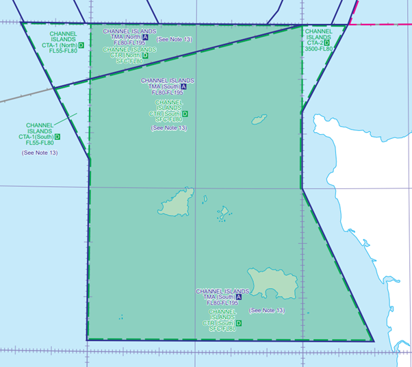
Channel islands Controlled Airspace, ENR 6-7
Airspace Infringement hotspots
From the north the main hotspot areas are around 50N, especially in the vicinity of ORTAC/LELNA. Due to the large expanse of water, there are no VRPs, so no navigational assistance in the form of VRPs. (Figure 1).
Aircraft operating from north of 50N should be aware that several ATC agencies can be involved, including Exeter Radar, Plymouth Military, Swanwick Military, London Information, Western Radar, Bournemouth Radar and Solent Radar, which could result in a late handover to Jersey ATC.
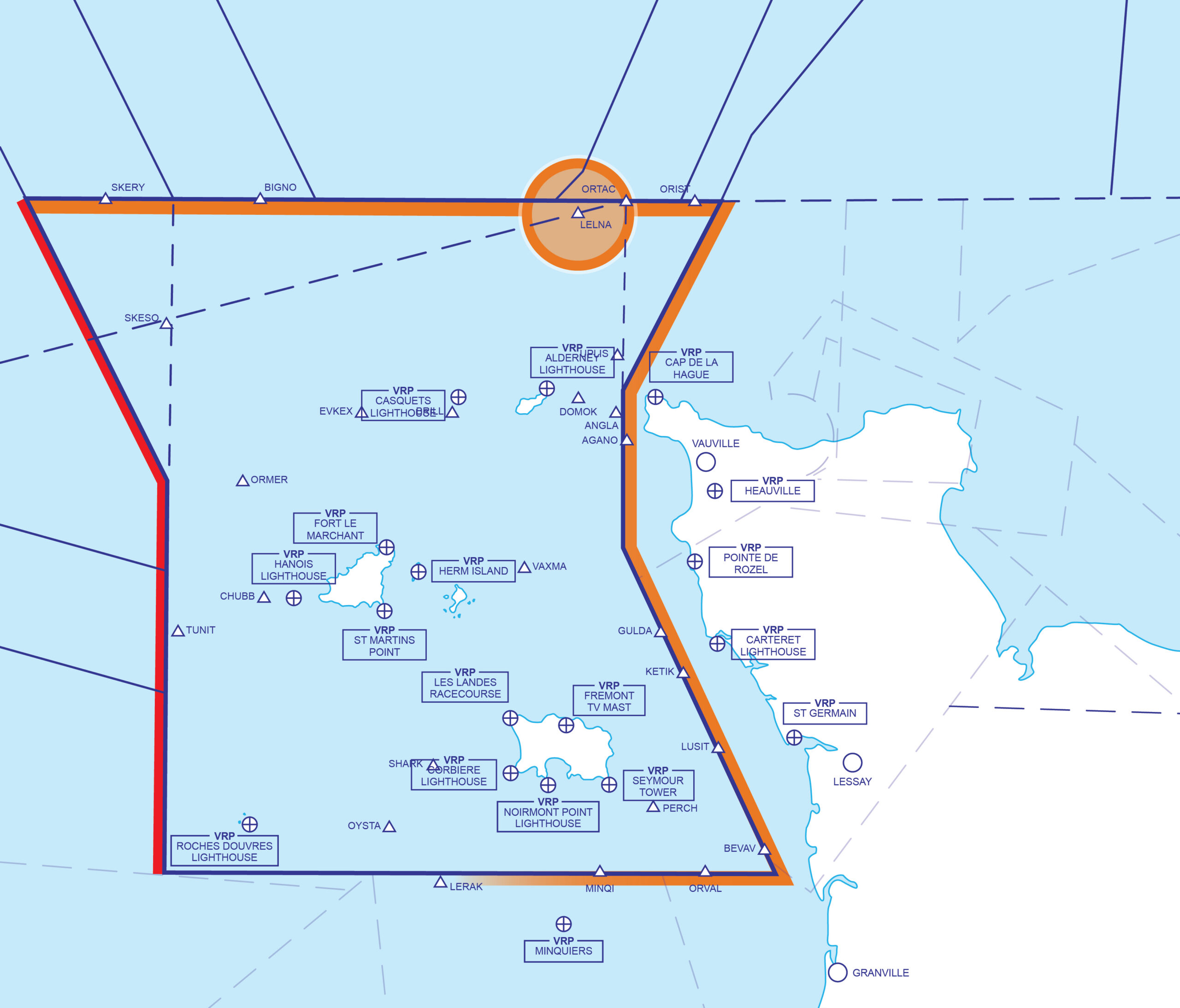
Figure 1 Channel Islands Airspace
From the east, most airspace infringements are caused due to proximity of the French coast to the eastern side of the controlled airspace or by pilots ‘cutting’ through the area in the southeast corner of the Channel Island CTR.
Hot-spots
- 50N
- LELNA
- Eastern CTR boundary
- South-eastern CTR boundary
Some of the IFR Standard Arrival Routes (STARs) for Runway 26 follow the eastern boundary of the Channel Islands Controlled Airspace (Figure 2).
Any airspace infringements have a big impact to Jersey ATC operations; however, infringements from the eastern boundary cause more complex issues because the Radar Controllers are required to give traffic avoidance advice and maintain a prescribed distance between inbound traffic and the infringing aircraft.
Visual Reference Points (VRPs)
There are six VRPs for Jersey and all sit outside the Channel Islands controlled airspace as shown in Figure 2.
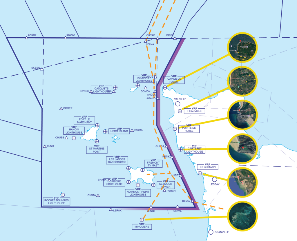
Figure 2 Channel Islands VRPS
Cap De La Hague
Cap De La Hague (494300N 0015600W) is the cape at the tip of the Cotentin peninsula in Normandy and 12NM northwest of the port of Cherbourg (Figure 3). To the south of the VRP lies LF P7 which is an H24 prohibited area at the fuel processing centre of la Hague (Manche) extending from the Surface to 3,900 feet AMSL. In the event of reinforcement of France’s national security alert system, a zone of 5 kilometres in radius may be put into effect by means of NOTAM. In this case, the Alderney – Cap de La Hague route cannot be used below 3,900 ft AMSL.
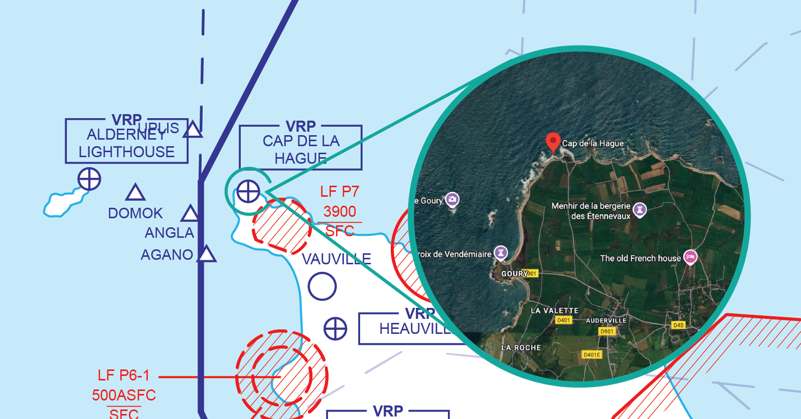
Figure 3 Cap De La Hague
Heauville
Heauville (Figure 4) (493459N 0014807W) is a small commune comprising some long hangar-like buildings and circular water storage tanks 1.6NM inland of the of the west coast of Normandy and 2.75NM southeast of the winch launch glider site at Vauville aerodrome (LFAU) and approximately 1.3NM northeast of the edge of the Flamanville prohibited area (P6-2).
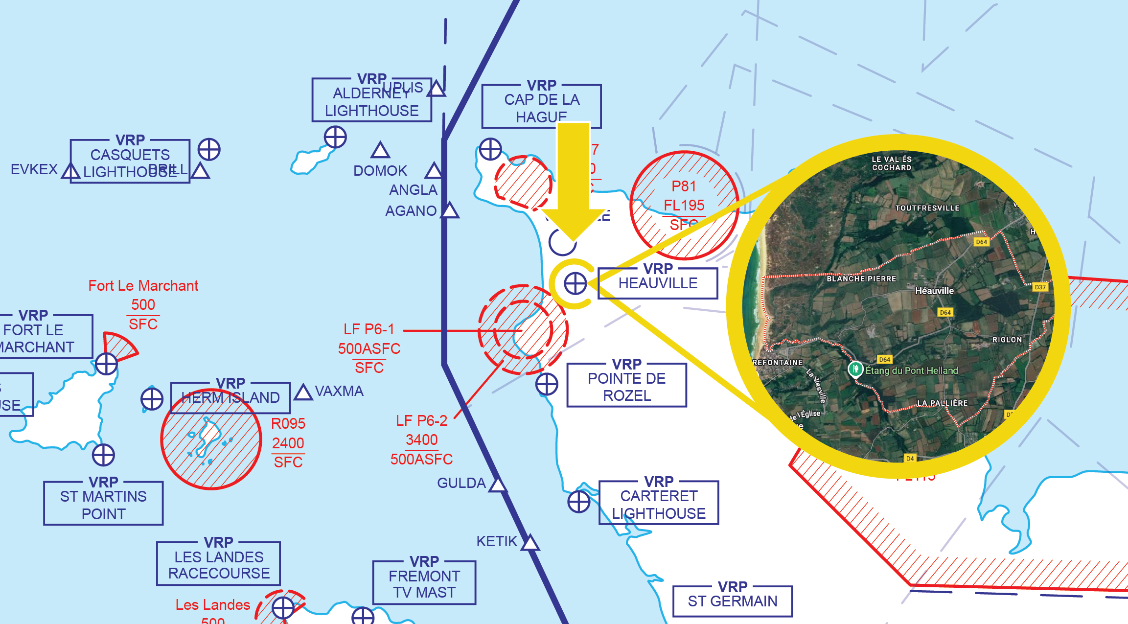
Figure 4 Heauville
Pointe de Rozel
Pointe de Rozel (492859N 0015059W) is a scenic viewpoint in Normandy situated 3NM southwest of the town of Les Pieux (Figure 5) . To the north of the VRP lies LF P6-1 and P6-2 which is an H24 prohibited area at the Flamanville nuclear power plant. P6-1 extends from the Surface to 500 feet Above Surface within 3KM of the site and P6-2 extends from 500 feet above surface to 3,400 feet AMSL within 5KM of the site.
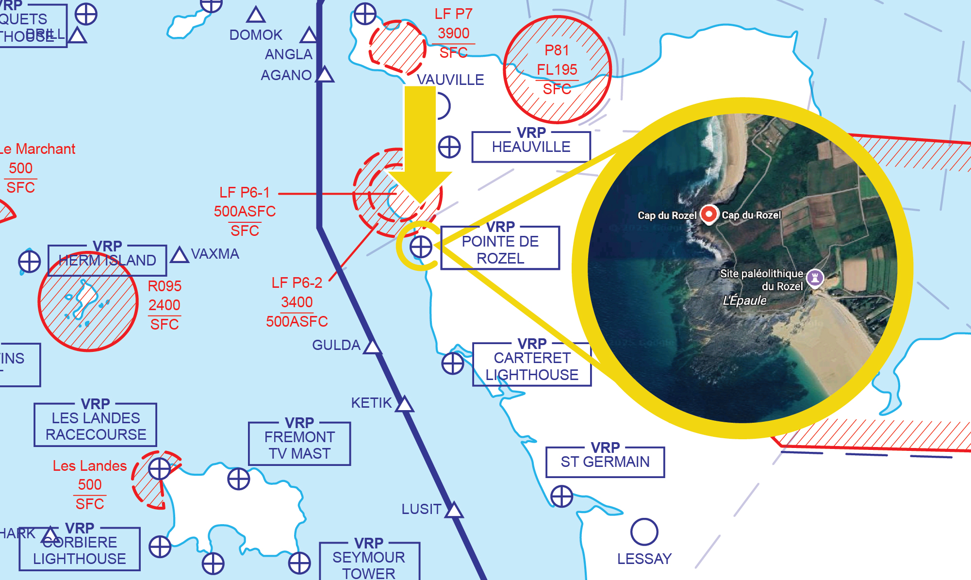
Figure 5 Pointe de Rozel
Carteret Lighthouse
Carteret Lighthouse (492224N 0014824W) lies on Cap de Carteret to the west of the town of Barneville-Carteret in Normandy (Figure 6). To the east of the lighthouse is a river leading inland to the Yacht Club.
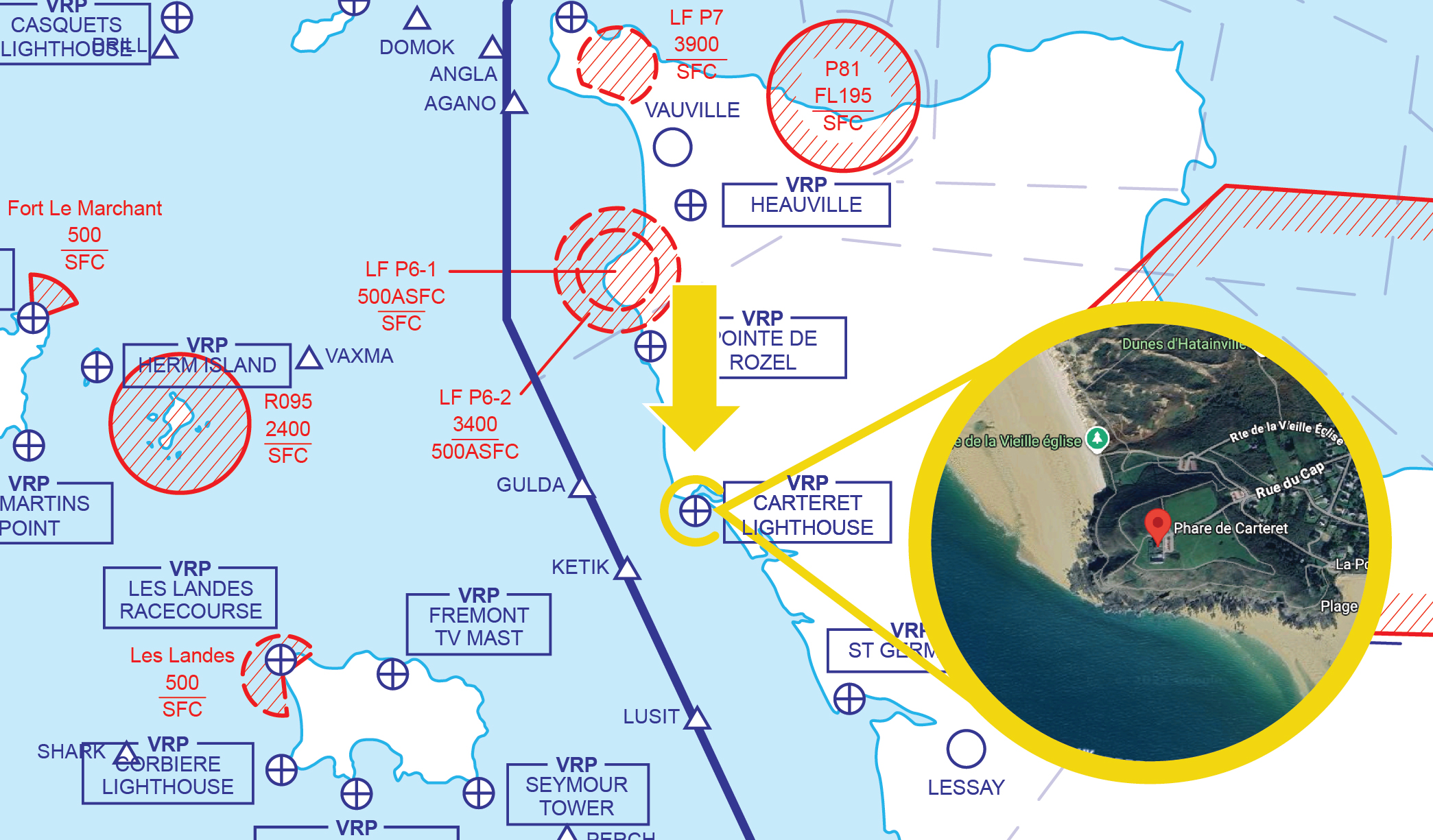
Figure 6 Carteret Lighthouse
St Germain
The VRP of St Germain (Figure 7) (491400N 0013800W) is the town that lies on the Normandy coast and is 4.5NM west northwest of the town and aerodrome of Lessay.
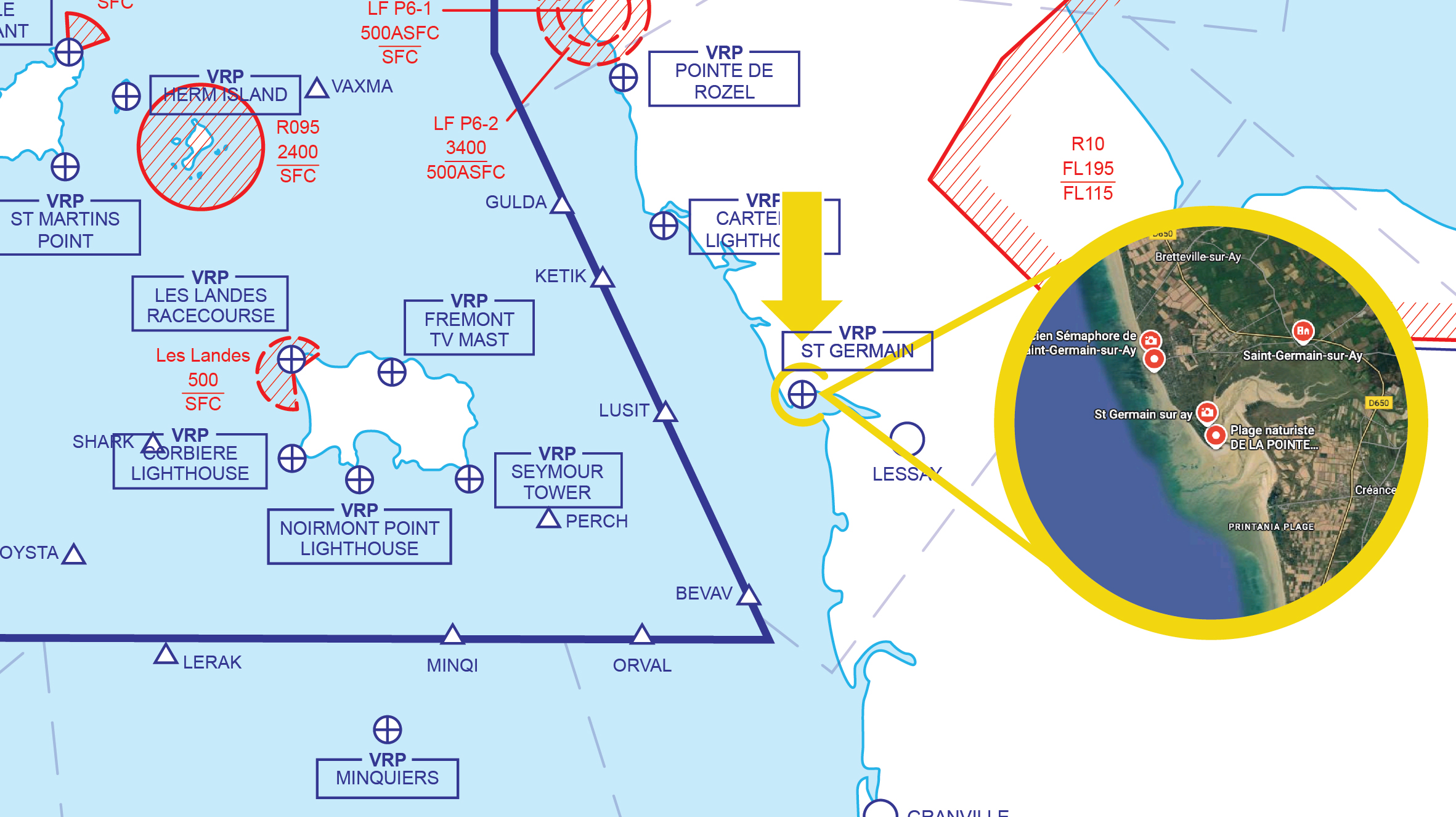
Figure 7 St Germain
Minquiers
Minquiers (485800N 0020800W) is a group of islands and rocks, approximately 12NM south of Jersey (Figure 8).
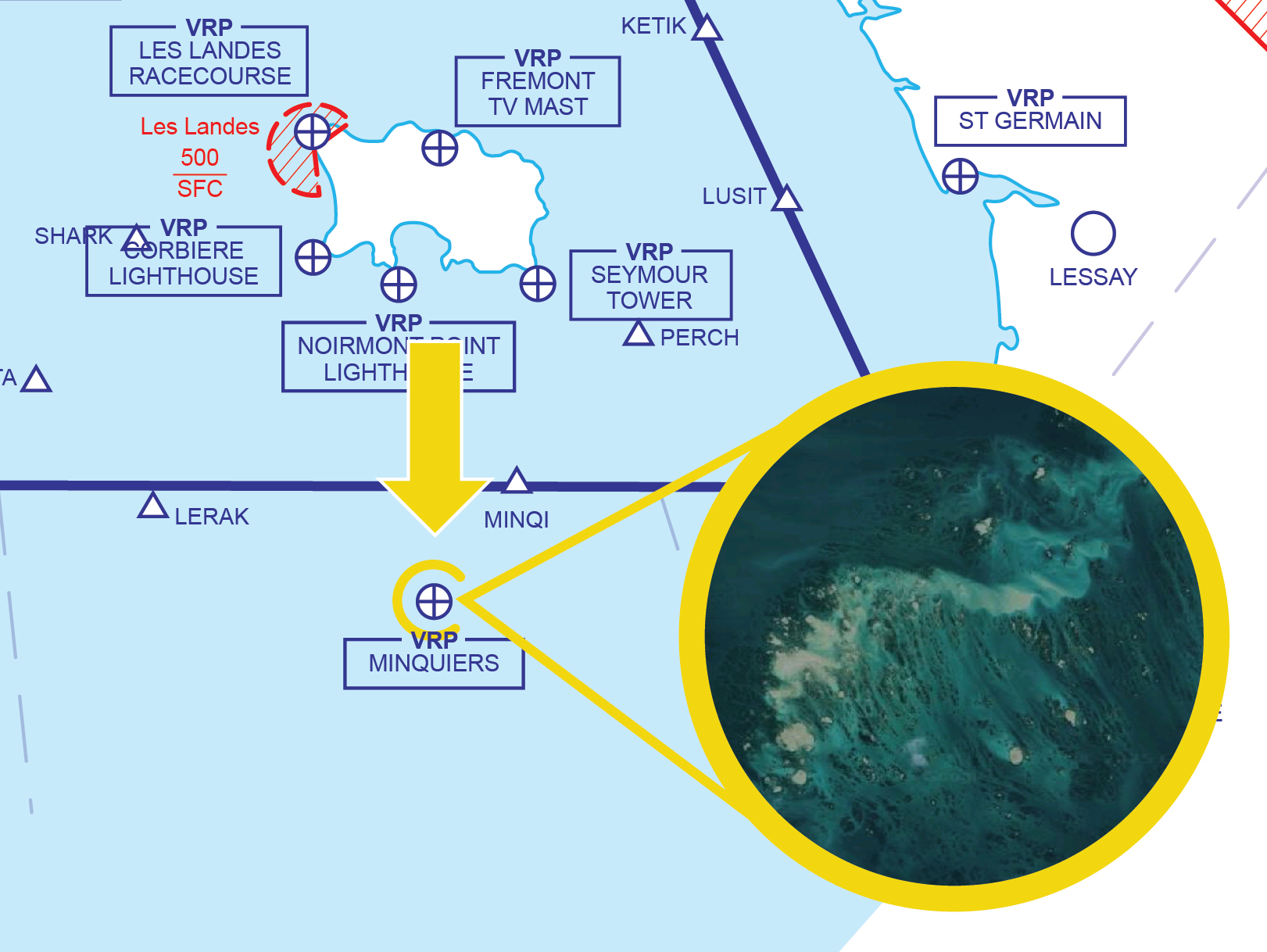
Figure 8 Minquiers
Standard routes established between Alderney & French Coast
Other route availability
Clearance is usually available to route between Alderney and the North or Western CTR boundary (50N003W) subject to the status of any Danger Area Activity. Remember that a clearance may not always be granted, so plan ahead and have a back-up route in mind.
Standard routes established between Guernsey & French Coast
Standard Routes have been established between:
- Fort Le Marchant (FORT) Guernsey and Pointe de Rozel (ROZEL)
- Guernsey and Roches Douvres Lighthouse
- Guernsey and 49N direction Dinard
Other route availability
A clearance is usually available to route between Guernsey and the North or Western Zone boundary (50N003W) subject to the status of any Danger Area Activity.
Standard routes established for Jersey
Standard Routes have been established between:
- Jersey’s Les Landes Racecourse(LLR) or Fremont TV Mast (FREM) and Cap de la Hague (CDLH)
- Jersey’s Les Landes Racecourse(LLR)or Fremont TV Mast (TVMST) and Pointe de Rozel (ROZEL)
- Jersey’s Les Landes Racecourse(LLR)or Fremont TV Mast (TVMST) and Carteret lighthouse (CART)
- Jersey’s Seymour Tower(SEYT) and Carteret lighthouse (CART)
- Jersey’s Seymour Tower(SEYT) and St. Germain (GERM)
- Jersey’s Seymour Tower(SEYT) direction Granville (GV)
- Jersey and Minquiers (MINQI)
- Jersey and Saint Brieuc (SB)
To prevent an airspace infringement
- Call at least 10 minutes before the CAS boundary.
- If unable to get 2-way comms, remain outside controlled airspace and consider holding whilst being aware of any controlled airspace in your vicinity.
- Plan you route, RT and clearance requests ahead and ensure you always have a plan B.
- Being allocated a squawk and given an ATC service is not permission to enter Controlled Airspace.
Briefing information
For further briefing information see Channel Island Airspace VFR Flight Planning Guide
It is the pilot’s responsibility to make sure they are fully briefed before departing.
Preventing infringements of the RAF Halton Aerodrome Traffic Zone (ATZ)
This infringement update is the 28th in a series of narratives focusing on identified infringement ‘hot-spots’ in the UK. It has been written by the Aerodrome Controlling Authority at RAF Halton and members of the Luton Local Airspace Infringement Team (LAIT).
Although originally due to close at the end of 2021, RAF Halton Station is now due to close at the end of 2025; however, a decision on the future of the Airfield will be made during 2025. Since October 2020, there have been a number of airspace infringements of the Aerodrome Traffic Zone (ATZ) at RAF Halton in Buckinghamshire. Whilst the primary role of the station is to train military and civilian personnel with Halton being the home to the RAF’s Recruit Training School, it is also home to an active military grass aerodrome. The aircraft that use the airfield are light aircraft (most used for instructional purposes), microlights, gliders (both powered and non-powered) and a small number of visiting aircraft. It is also often used by other military aircraft on training exercises.
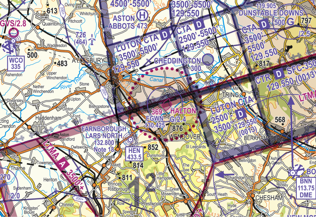
Figure 1
Halton has four runways designated at 02/20 and 07/25. Circuits are flown to the north/northwest of the aerodrome (20 and 25 right-hand and 02 and 07 left-hand) at 1,000 feet QFE (1,400 feet QNH) with no overhead joins permitted due to the glider operations. The aerodrome is also notified as a glider site with both aero tow and winch launching. To facilitate the latter, cables are notified up to 2,400 feet above mean sea level (G/2.4) as in Figure 2. The aerodrome is also the subject of a Yellow Aeronautical Information Circular (Y031/2020) relating to flypasts by either a military fast-jet, multi-engine aircraft or helicopter, normally every 2 weeks, as part of graduation ceremonies at the RAF Recruit Training Squadron (Figure 3).
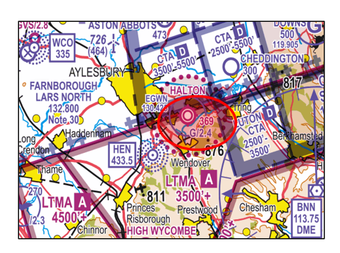
Figure 2
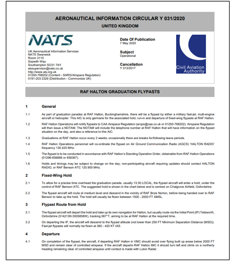
Figure 3
To provide protection to aircraft operating at the aerodrome, a Class G Aerodrome Traffic Zone (ATZ) of 2NM radius extending to 2,000 feet above aerodrome level (2,370 feet above mean sea level) exists as per Article 5 of the Air Navigation Order 2016.
The ATZ is served by an air/ground communication service (AGCS) between the hours of 0900 to 2000 hours local or Sunset plus 15 minutes whichever is earlier by HALTON RADIO on frequency 130.425MHz. The aerodrome is open every day of the year (except Christmas Day and New Year’s Day). Therefore, between these hours (or hours as notified by NOTAM), in accordance with Rule 11 (5) of The Rules of the Air Regulations 2015, the commander of an aircraft must obtain information from the AGCS to enable the flight to be conducted safely within the ATZ.
Halton AGCS relies on pilots making clear, accurate radio calls to generate situational awareness to maintain the safety of all aircraft operating in the ATZ. As a reminder, Rule 11(6), as applied to Halton, requires that the commander of an aircraft flying within the Halton ATZ must maintain a continuous watch on 130.425MHz and communicate the aircraft’s position and height to Halton Radio on 130.425MHz on entering the ATZ and immediately prior to leaving it.
Halton and Luton Controlled Airspace
Halton lies approximately 5NM to the west of the Luton Class D Control Zone (CTR) and under parts of 3 Control Areas (CTA) as follows (Figures 4 and 5):
- CTA-4 to the north with a base of 3,500 feet amsl and a ceiling of 5,500 feet amsl;
- CTA-3 to the northeast with a base of 2,500 feet amsl and a ceiling of 5,500 feet amsl; and
- CTA-2 to the southeast with a base of 2,500 feet amsl and a ceiling of 3,500 feet amsl.
Above all CTA lies the Class A London Terminal Control Area (LTMA).
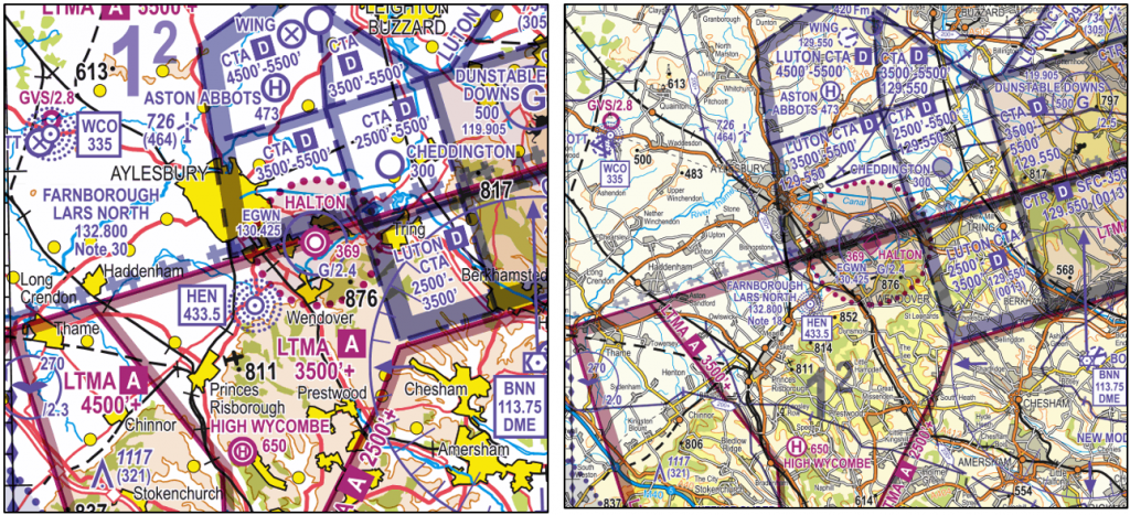
Figure 4 and Figure 5
Whilst several infringements have involved aircraft flying directly overhead the aerodrome at or below circuit height, it is important to identify the local features to assist application of Threat and Error Management when planning your flight and then flying through the area. In Figure 6 the ATZ boundary is marked in red with prominent local features as follows:
Aylesbury. The southeast part of the town of Aylesbury lies within the Halton ATZ so it is not possible to transit a gap between the ATZ and the town below 2,370 feet amsl without being in 2-way communication with Halton AGCS
Wendover (to the south) and Stoke Mandeville (to the west) lie within the ATZ. Tring (to the east) lies on the edge of the ATZ but there is no gap between the town and the ATZ.
Wilstone Reservoir lies partly within the ATZ to the northeast. By remaining to the east of the reservoir, you will be outside the ATZ.
The London to Milton Keynes railway line acts as good feature to follow to remain both clear of the ATZ and the Luton CTR once north of Berkhamsted. As the railway line routes through Berkhamsted it is within the Luton CTA (Surface to 3,500 feet amsl).
The Grand Union Canal runs alongside the railway line between Berkhamsted and the 3 lakes/small reservoirs to the north of Tring. As with the railway line, the canal also routes through the town and is therefore within the Luton CTA (Surface to 3,500 feet amsl). Once to the north of Tring, the canal routes west and into the ATZ towards Aylesbury.
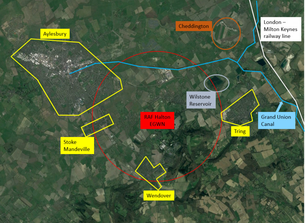
Figure 6
Managing the threat of mid-air collision and airspace infringements
Pilots planning to fly to the east of the ATZ and west of the Luton CTR should be aware that not only is the gap between the ATZ and the Luton CTR narrow at just 2.75NM but to the north of the gap lie 3 active grass strips at Cheddington, Wing and Holmbeck Farm. In addition, to the northwest of RAF Halton lies the Wescott NDB (WCO/335) and to the southwest is the Henton NDB (HEN/433.5). As the number of radio navigation aids reduce, the popularity of the 2 beacons increase for pilot training; when tranisting to the west of Halton, pilots should be aware of the increased likelihood of pilots carrying out such training.
Whilst the vertical limits of airspace in the vicinity of Halton does allow for a transit above the ATZ/maximum winch cable height and below the Luton CTA-4, there remains a possibility of encounters with gliders, and other aircraft, above the aerodrome.
The risk of mid-air collsion can be reduced by ensuring that transponders are used, with MODE C (ALT,) at all times and consideration be given to the use of a functional Electonic Conspicuity (EC) device; however, pilots should also be alert to the possibility of non-participating EC aircraft and lack of interopearbility between some devices leading to only a limited EC ‘picture’.
Preventing an airspace infringement
The Airspace & Safety Initiative website provides extensive advice on how to avoid the risk of infringing airspace. Pilots are strongly encouraged to:
Use a Moving Map – which will provide a profile along your planned route showing the controlled airspace boundary. When flying in proximity to the ATZ and Luton controlled airspace, and if able to, TAKE2.
Understand and Apply Rule 11 – To fly in the Halton ATZ, pilots must obtain information from the AGCS (callsign HALTON RADIO on frequency 130.425MHz) to enable the flight to be conducted safely within the ATZ. If you are unable to establish 2-way communications or if told to “Standby” you must not enter the ATZ.
Plan ahead and have a contingency plan (Plan B) – Especially during busy periods, the frequency may be busy and so sufficient time should be allowed in order to establish two-way communication and aerodrome information. Have a backup plan should you be unable to establish contact. This may involve re-routing or holding within the local area, being careful of other airspace in the vicinity.
Reference material
Read Airspace and Safety Initiative Hotspot narratives:
- Number 14 – Infringements of Aerodrome Traffic Zones (ATZ); and
- Number 24 – Preventing infringements of Luton Controlled Airspace
Winch launch glider activity – Download British Gliding Association Winch cable warning poster
Threat and Error Management – Read Threat & Error Management
Preventing airspace infringements in the vicinity of Edinburgh
This infringement narrative is number 29 in a series of narratives that are issued focusing on identified infringement ‘hot-spots’ in the UK. The aim is to provide pilots operating the area with useful information on airspace and infringement prevention practices. This narrative has been written by the Air Traffic Service Unit at Edinburgh.
In the 18 months from January 2020 to June 2021, Air Navigation Solutions Ltd, the air navigation service provider (ANSP) for Edinburgh Airport has noted an increase in the number of airspace infringement occurrence of the Edinburgh Control Zone (CTR) and Control Areas (CTA). To alert controllers of airspace infringements, Edinburgh ATC has an Airspace Infringement Warning safety net that operates on Edinburgh QNH.
The Airspace
The Edinburgh airspace is relatively simple in construct and lies underneath the Class D Scottish Terminal Control Area (CTA). It comprises one CTR and 4 CTA as in Figure 1 as follows:
The CTR which is a circle of 10NM radius extending from the surface to 6,000 feet amsl.
CTA-1 is a stub to the southwest extending from 2,500 feet amsl to 6,000 feet amsl;
CTA -2 is the area to the northeast extending from 2,500 feet amsl to 6,000 feet amsl;
CTA-3 lies to the northwest of the airport and extends from 3,500 feet amsl to 6,000 feet amsl; and
CTA-4 lies to the south and also extends from 3,500 feet amsl to 6,000 feet amsl.
Figure 1
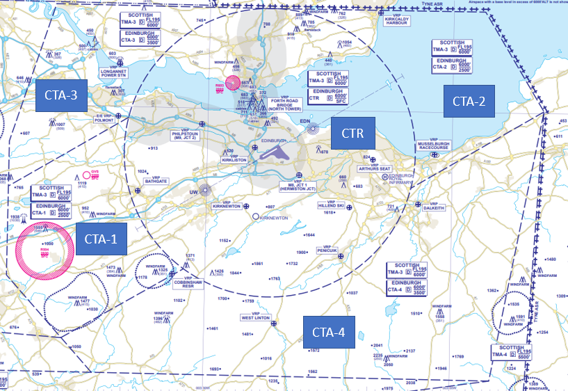
Some 70% of infringements were reported as lateral infringements at the edge of CTA 2 and 3 (Figure 2). Unlike in other areas of the UK, very few infringements result from pilots inadvertently climbing into the CTAs.
Figure 2
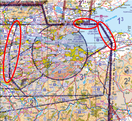
As part of the ANSP’s responsibilities, it is required to carry out post-occurrence analysis. One of the key findings is that several recent infringement occurrences could have been prevented or resolved in a timely manner had the pilot been using the Frequency Monitoring Code process. For Edinburgh, the squawk is 0440 and the associated frequency is 121.205 MHz. Rather than squawking 7000 or 2000 and operating autominously, pilots are encouraged to use the FMC. The area in which the FMC should be used is published in the UK AIP in the aerodrome directory at EGPH AD2.22 (Figure 3)
Figure 3
This area is not subject to charting on the 1:250,000 and 1:500,000 VFR charts to reduce the amount of lines etc but is depicted on the chart at Figure 4 To the north, east and south it is equated to an area when within 5NM of the boundary of the CTAs and it follows the western edge of the CTA from north to south due to the location of the Cumbernauld Aerodrome Traffic Zone to the west of CTA-3 and the requirement to comply with The Rules of the Air Regulations, Rule 11(5) and 11(6).
To use an FMC correctly, pilots should:
- a) select Edinburgh Approach frequency of 121.205 MHz the radar controller’s radio frequency BEFORE selecting the appropriate FMC ensuring that the radio’s volume is tuned up to a level that transmissions man be received and understood;
- b) select the squawk (Mode A) of 0440 using ALT (Mode C) if the transponder is so equipped;
- c) listen out for any transmissions with the aircraft’s callsign or position.
Note: Edinburgh Radar is Mode S equipped so if the aircraft is equipped with MODE S, the pilot will be issued a warning based on the aircraft’s registration/callsign. If the aircraft is not equipped with MODE S, the pilot will be issued with a warning based on the aircraft’s position.
Figure 4
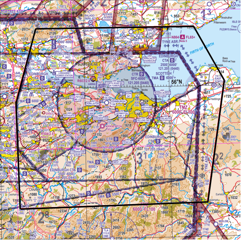
More details on the use of FMC can be found in AIC Y085/2020 on the NATS AIS website, and in the UK AIP at ENR 1.6 section 2 (SSR) and at the chart at ENR 6-80
Visual reference points
Edinburgh has 17 VRPs of which 2 are in the vicinity of the edge of the CTA and 6 are under the CTA which has a base of 2,500 feet amsl. The remaining 9 are located in the CTR with a base of surface level.
| Column 1 | Column 2 | Column 3 |
| In the vicinity of the edge of the CTA | Under the CTA but outside the CTR | Inside CTR |
| Kirkcaldy Harbour VRP | Musselburgh Racecourse | Arthurs Seat |
| Kelty | Dalkeith | Hillend Ski |
| West Linton | Penicuik | |
| Cobbinshaw Reservoir | M8 Junction 1 (Hermiston Jct) | |
| Polmont | Bathgate | |
| Longannet Power Station | Kirknewton | |
| Kirkliston | ||
| Philpstoun (M9 Jct 2) | ||
| Forth Road Bridge, North Tower |
To prevent an airspace infringement, as part of their pre-flight planning and in-flight execution, as well as using the Frequency Monitoring Code pilots are strongly encouraged to:
Use a Moving Map and, when able to, Take 2. The CAA actively encourages pilots to use VFR Moving Maps as part of their planning methodology, and when in flight, because they can enhance a pilot’s positional situational awareness and can also offer timely alerts to airspace and aviation hazards. However, Moving Map technology should not be the sole means of planning or navigation as highlighted in the European General Aviation Safety Team, Safety Promotion Leaflet, Using Advanced Navigation Technology Safely (EGAST GA7 page 3 refers).
It is also important to remember that Moving Map APPs are not regulated by the CAA and users should note that their depiction of aeronautical information may be different to the UK Aeronautical Information products accessed via the NATS AIS website, such as VFR charts, the UK AIP and NOTAM information (NATS AIS is the authorised source of UK aeronautical information provided on behalf of, and regulated by, the CAA).
Make a Detailed Plan. Build in your climb and descent points when routing in the vicinity of multiple CTAs with differing base altitudes. Know what VRPs look like and what airspace lies above them or close by. Have a point beyond which you are not going to fly if you do not have a positive clearance to enter controlled airspace; in the case of departing Nottingham, this should be the lateral confines of the ATZ.
If appropriate – request a clearance. If for any reason a climb is required above the base of the CTA, then a clearance must be obtained. Depending on a variety of factors, not least the runway in use and traffic situation at the time, this may well be available. By obtaining a clearance to enter controlled airspace when appropriate, ATC is able to control more effectively and ensure safety is maintained
Monitor the DME. The Edinburgh DME is on frequency 108.9. If you tune into the DME and remain at more than 10 NM and below 2,500 QNH, you will remain outside of the CTR thereby preventing a lateral infringement.
Do not fly on an RPS in the vicinity of the Edinburgh CTAs or below the Scottish TMA. The airspace underneath the Scottish TMA does not form part of the Altimeter Setting Region RPS system. (Figure 5) In this area pilots should use the QNH of an adjacent aerodrome when flying at or below the Transition Altitude. It may be assumed that for aerodromes located beneath such Areas, the differences in the QNH values are insignificant. If you are receiving a FIS from Scottish Flight Information Service, and approaching the TMA, ask the FISO for the Edinburgh QNH or obtain the QNH from the ATIS at Edinburgh (131.355 MHz), the Scottish VOLMET on 125.725 MHz or from an adjacent air traffic service unit.
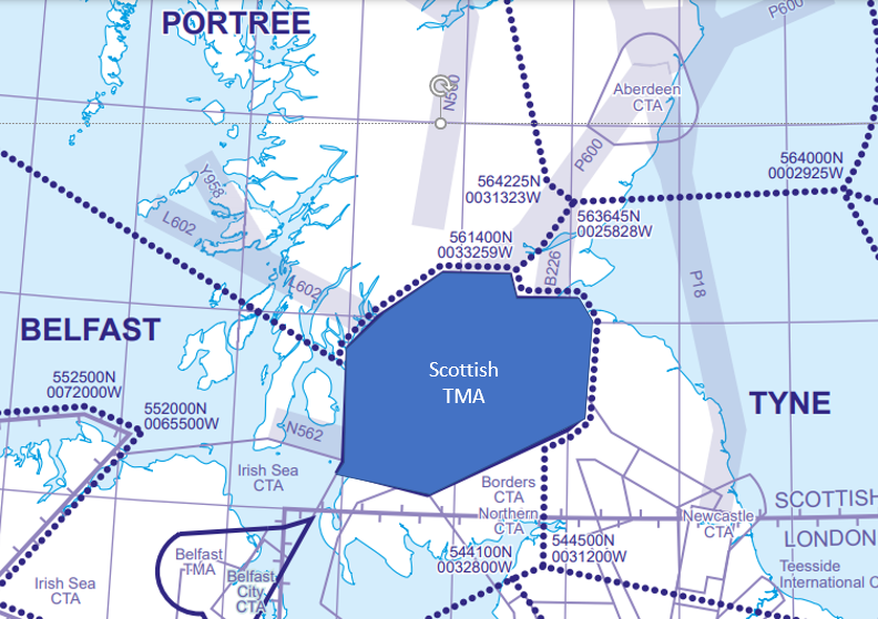
Preventing ATZ infringements of the RAF Syerston Aerodrome Traffic Zone (ATZ) and Temporary Danger Area (TDA) EG D397
This infringement update is the 30th in a series of narratives focusing on identified infringement ‘hot-spots’ in the UK. It has been written by the Aerodrome Controlling Authority at RAF Syerston and members of the CAA’s Airspace Infringement Team.
It has been updated to inform pilots of the recent notification that a Temporary Danger Area (TDA) will be established at the aerodrome from 9 January 2023 to 7 April 2023 for the purposes of display rehearsals by the Royal Air Force Aerobatics Team (RAFAT).
RAF Syerston is located approximately 5NM southwest of the town of Newark on Trent in Lincolnshire. It is home to 2 Flying Training School (2 FTS) and houses both the headquarters and the RAF Central Gliding School (CGS), which provides formal training courses for members of the Volunteer Gliding Squadrons (VGS) located at various other locations around the UK. The aerodrome is a busy gliding site and its staff provides flying training to the RAF Air Cadets using the Viking T Mk 1 glider. The CGS teaches qualified gliding instructors who will go on to teach Air Cadets gliding at various locations around the UK as well as being responsible for instructor standards. In recent years there have been several airspace infringements including one in November 2018 which resulted in in an encounter with a glider; in that incident the aircraft passed the glider about 100-200 feet to the left and at a similar altitude.
Syerston has 6 runways designated as 06/24, 11/29 and 15/33 and is notified as a winch launch glider site with both aero tow and winch launching. To facilitate the latter, cables are notified up to 3,300 feet above mean sea level (G/3.3). (Figure 1)
Figure 1 – Correct at Sheet 6 England East Edition 15 (2021)
The aerodrome lies within a busy volume of Class G airspace to the northeast of East Midlands Airport with its Class D Control Zone and Control Areas known as the Lincolnshire Area of Intense Aerial Activity (AIAA).
A Class G Aerodrome Traffic Zone (ATZ) of 2NM radius extending to 2,000 feet above aerodrome level (2,231 feet above mean sea level) exists as per Article 5 of the Air Navigation Order 2016 with Syerston being notified, for the purposes of Rule 11 of The Rules of the Air Regulations 2015, as a Government Aerodrome (Figure 2). For the purposes of Rule 11(5), Syerston Radio’s operating hours are 0830 hours local to Sunset + 15 minutes (0730 hours UTC to Sunset + 15 minutes). This means that during the notified hours above, the commander of the aircraft must obtain information from the air/ground communication service to enable the flight to be conducted safely within the ATZ. In addition, when inside the ATZ, the commander of the aircraft must maintain a continuous watch on the Syerston Radio frequency (128.525 MHz); they must also communicate the aircraft’s position and height to Syerston Radio on entering the ATZ and immediately prior to leaving it.
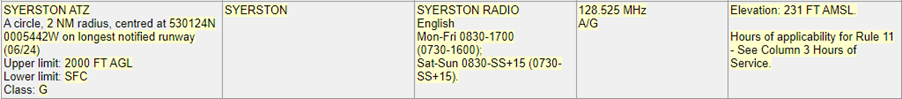
Figure 2 – Correct at AIRAC 11/2022
Pilots should not plan to transit directly overhead the aerodrome, even above the ATZ, as winch launching activity extends to 3,300 feet above mean sea level and there is a risk of a cable strike (Figure 3). A 4.5 mm Dyneema or steel wire in the air, when struck by an aircraft could have fatal consequences for both the aircraft impacting the wire and the glider, if still attached to the cable. Pilots should be aware that the vertical extent relates only to the maximum altitude of the cable and not to the maximum altitude to which gliders may be encountered operating in the airspace above the ATZ.
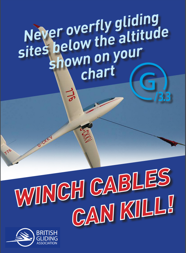
Figure 3 – Winch Cables Can Kill!
As mentioned above, the aerodrome is located in the Lincolnshire AIAA with many aviation sites in the local vicinity (Figure 4).
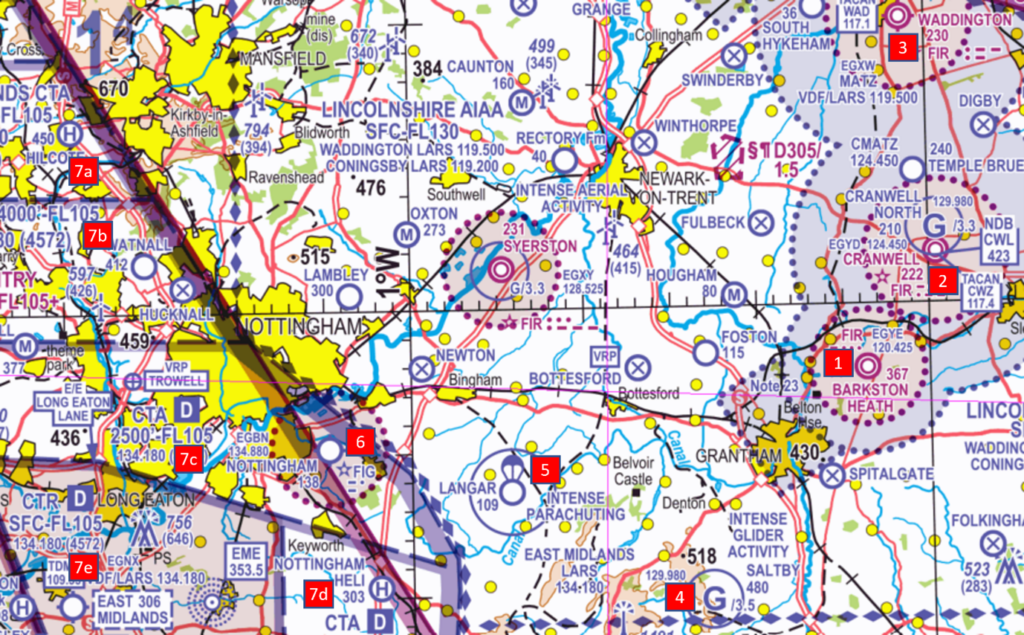
Figure 4 – Correct at Sheet 2171CD Southern England and Wales Edition 48 (2022)
Immediately to the east lie 3 active RAF aerodromes which are home to mixed types of aircraft engaged in both the operational and training roles:
- RAF Barkston Heath (1) with an ATZ (2NM radius extending to 2,367 feet amsl) and a MATZ;
- RAF Cranwell (2) with an ATZ (2.5NM radius extending to 2,222 feet amsl), a MATZ and a winch launch glider site notified up to 3,300 feet amsl; and
- RAF Waddington (3) ATZ (2.5NM radius extending to 2,230 feet amsl) and a MATZ.
13NM to the southeast and within an area notified as intense gliding activity is Saltby Aerodrome (4) with winch launch gliding activity notified with cables extending to 3,500 feet amsl.
7.5NM to the south lies Langar Aerodrome (5) which is home to Skydive Langar and annotated on the VFR Charts as a site of intense parachute activity within a circle of 1.5NM radius with an upper limit of FL150. (Figure 5)
Figure 5 – Correct at AIRAC 11/2022
Nottingham Aerodrome (6) lies 8.5NM to the southwest with an ATZ (2NM radius extending to 2,138 feet amsl) served by Nottingham Radio on 134.880 MHz.
To the west and southwest lies the East Midlands Class D controlled airspace complex comprising the CTR-1 (7e) from surface to FL105 and 20 Control areas (CTA). Within 15NM of Syerston there are 4 CTA as follows:
- CTA-19 (7a) extending from 5,500 feet amsl to FL105;
- CTA-7 (7b) extending from 4,000 feet amsl to FL105;
- CTA-1 (7c) extending from 2,500 feet to FL105; and
- CTA-2 (7d) extending from 1,500 feet to FL105.
Hot-spot narrative number 8 was updated in 2021 and helps pilots understand the airspace infringement risk in the controlled airspace to the east of East Midlands airport.
Temporary Danger Area (TDA) – EG D397
A TDA may be established around the site of unusual aerial activity when it is considered that the activity associated with the activity could be hazardous to flight. TDAs will be notified by NOTAM, which may be supplemented by a yellow Aeronautical Information Circular (AIC).
From the 9 January 2023 to 7 April 2023, a TDA designated as EG D397 will be established at RAF Syerston to facilitate the safe operation of the Royal Air Force Aerobatics Team (RAFAT) conducting training where high energy manoeuvres will take place.
What will the TDA consist of?
The TDA will consist of one Danger Area bounded by a circle of 5NM radius whose centre is at 530124N 0005442W. It will be established between surface and 5000 feet amsl. (Figure 6)
When will the TDA be active?
Activation of the TDA could take place Monday to Friday with the following slot times:
- 0830-0915 hours UTC,
- 1200-1245 hours UTC; and
- 1450-1530 hours UTC.
The actual dates and times of activation will be promulgated by NOTAM no less than 72 hours prior to the planned flight.
How can I check if the TDA is active?
During pre-flight planning, a pilot should carry out a NOTAM brief using the NATS AIS Internet Briefing System. If the TDA is active a NOTAM will be promulgated, detailing the date and time of activation. You can also access the published Yellow AIC (Y 115/2022) through the NATS website to provide more information. Pre-flight information will also be available from RAF Waddington ATC via telephone number (01522) 727452.
While in flight, a Danger Area Activity Information Service (DAAIS) will be available from Waddington Zone on 119.500 MHz or London Information on 124.600 MHz. A DAAIS will provide an update of the activity status of the danger area. Any information obtained from a DAAIS is not a clearance to cross the danger area, whether or not it is active. Pilots are advised to assume the danger area is active, even if no DAAIS is obtained and must obtain as much information as possible regarding the danger area during their pre-flight briefing procedures.
A Danger Area Crossing Service (DACS) will be available from Waddington Zone on 119.500 MHz and 232.700 MHz. Pilots should call up on frequency when approaching the danger area and request a clearance prior to entry. The DACS unit will, if the danger area activity permits, provide a clearance for an aircraft to cross the danger area under a suitable type of service. It may not be possible to accommodate a crossing of the danger area during its notified hours of operation and it is therefore important that pilots do not assume they will get a clearance. Ensure to call up on frequency with plenty of time and have an alternative route planned if clearance is not granted, making sure to remain outside of the danger area.
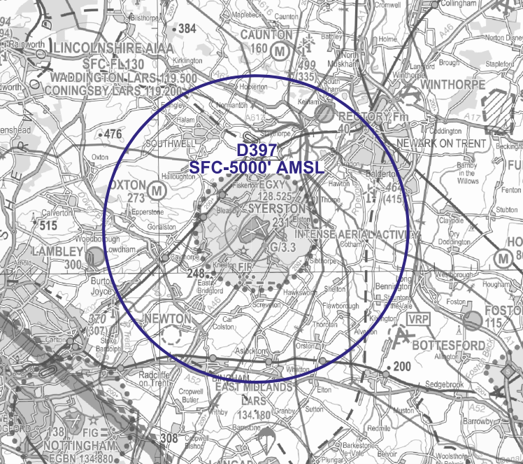
Figure 6 – Correct at AIC Y 115/2022
Preventing an airspace infringement
The Airspace & Safety Initiative website provides extensive advice on how to avoid the risk of infringing airspace. Pilots are strongly encouraged to:
Use a VFR Moving Map. In recent causal factor analysis, the correct use of VFR Moving Map technology could have prevented 85% of analysed airspace infringements from occurring. Based on these statistics the CAA actively encourages pilots to use VFR Moving Maps as part of their planning and when in flight, because they can enhance a pilot’s positional situational awareness and can also offer timely alerts to airspace and aviation hazards. However, Moving Map technology should not be the sole means of planning or navigation as highlighted in the European General Aviation Safety Team, Safety Promotion Leaflet, Using Advanced Navigation Technology Safely (EGAST GA7 page 3 refers).
It is also important to remember that Moving Map APPs are not regulated by the CAA and users should note that the depiction of aeronautical information on VFR Moving Maps may be different to that on the UK Aeronautical Information products accessed via the NATS AIS website, such as VFR charts, the UK AIP and NOTAM information (NATS AIS is the authorised source of UK aeronautical information provided on behalf of, and regulated by, the CAA).
When using VFR Moving Maps, although the gliding symbol is reasonably clear, the difference in presentation from the CAA chart is significant. Pilots are to be aware that on some VFR Moving Maps:
- There may be no indication of winch launching;
- There may be no information of the maximum height of winch launches. To obtain that information the user needs to open the information tile by pressing on the glider site symbol and read the information contained in the ‘Airspace’ section (Figure 7).
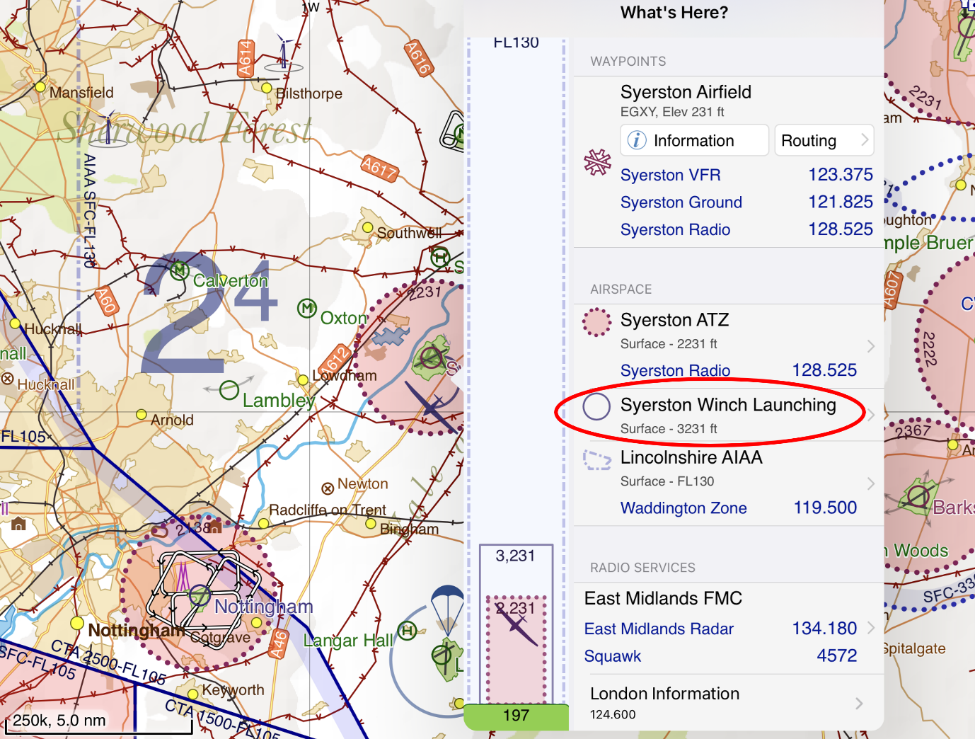
Figure 7 – VFR Moving Map information
Understand and apply Rule 11 – To fly in the Syerston ATZ, pilots must obtain information from the AGCS (callsign SYERSTON RADIO on frequency 128.525 MHz) to enable the flight to be conducted safely within the ATZ. If you are unable to establish 2-way communications or if told to “Standby” you should not enter the ATZ.
Plan ahead and have a contingency plan (Plan B) – Especially during busy periods, the frequency may be busy and so sufficient time should be allowed in order to establish two-way communication and aerodrome information. Have a backup plan should you be unable to establish contact. This may involve re-routing or holding within the local area, being careful of other airspace in the vicinity.
Reference material
Hot-spot narratives
- Number 14 – Infringements of Aerodrome Traffic Zones (ATZ); and
- Number 8 – Preventing infringements of East Midlands
Winch launch glider activity – British Gliding Association Winch cable warning poster
Threat and Error Management – Read Threat & Error Management
European General Aviation Safety Team, Safety Promotion Leaflet (EGAST) GA7 -Using Advanced Navigation Technology Safely read EGAST GA7
Preventing airspace infringements in the vicinity of Aberdeen
This infringement narrative is number 31 in a series of narratives that are issued focusing on identified infringement ‘hot-spots’ in the UK. The aim is to provide pilots operating the area with useful information on airspace and infringement prevention practices. This narrative has been written by the Air Traffic Service Unit at Aberdeen and local pilots.
Aberdeen airport is not only an international airport, but it is also the main heliport for offshore North Sea oil and gas industry with helicopters serving platforms as far away as the west and east sides of Shetland around 200 NM away. In 2019 the airport served over 91,000 aircraft movements for almost 3 million passengers. To accommodate concurrent fixed-wing and rotary-wing movements, the airport has 2 fixed-wing runway (16/34) and 5 runways which are available for helicopter use only (H14/H32, H05/H23 and H36).
The Airspace
The Aberdeen airspace is relatively simple in construct and lies at the confluence of several CTA into and out of the Aberdeen CTA/CTR (Figure 1).
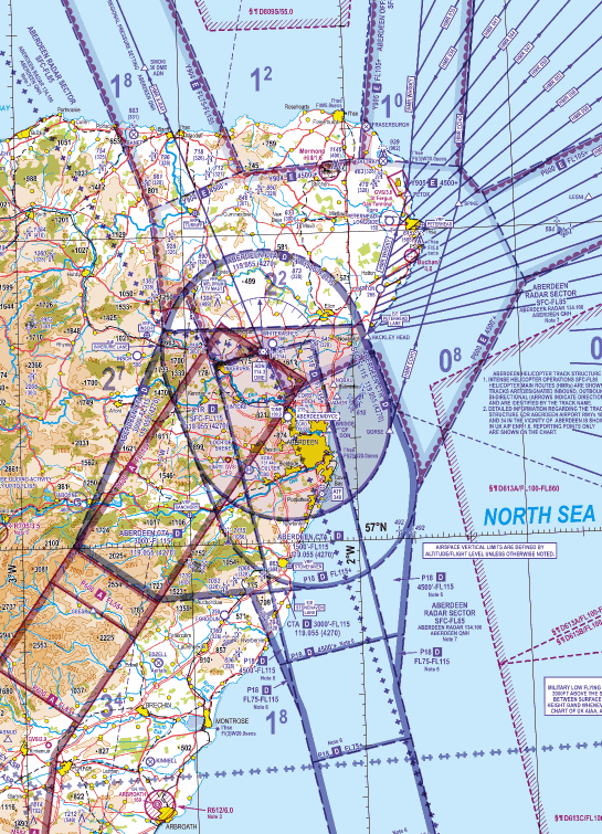
Figure 1: Aberdeen airspace
The Aberdeen airspace comprises one CTR and 3 CTA as in Figure 2:
- A ‘clipped lozenge’ shaped CTR extending from the surface to FL115;
- CTA-1 is a completed the lozenge to the north extending from 1,500 feet amsl (based on the Aberdeen QNH) to FL115;
- CTA -2 is the area to the south again extending from 1,500 feet amsl to FL115; and
- CTA-3 lies to the west/southwest and extends from 3,000 feet amsl to FL115.
A Class D CTA (airway) 10 NM wide extends from the ADN VOR/DME southbound extending upwards from FL115 above CTA 2 and upwards from 4,500 feet with rising bases further to the south and is designated P18;
A Class A CTA (airway) 10 NM wide extends from the ADN VOR/DME southwest bound extending upwards from FL115 above CTA-3 and from upwards from FL55 also with rising bases further to the southwest and is designated P600; and
To the north and northeast lie the 3 Class E CTA with Transponder Mandatory Zones of Y904, Y905 and P600; all have a base of 4,500 feet amsl. Further details can be found in the UK AIP at ENR1.4 and 3.1.
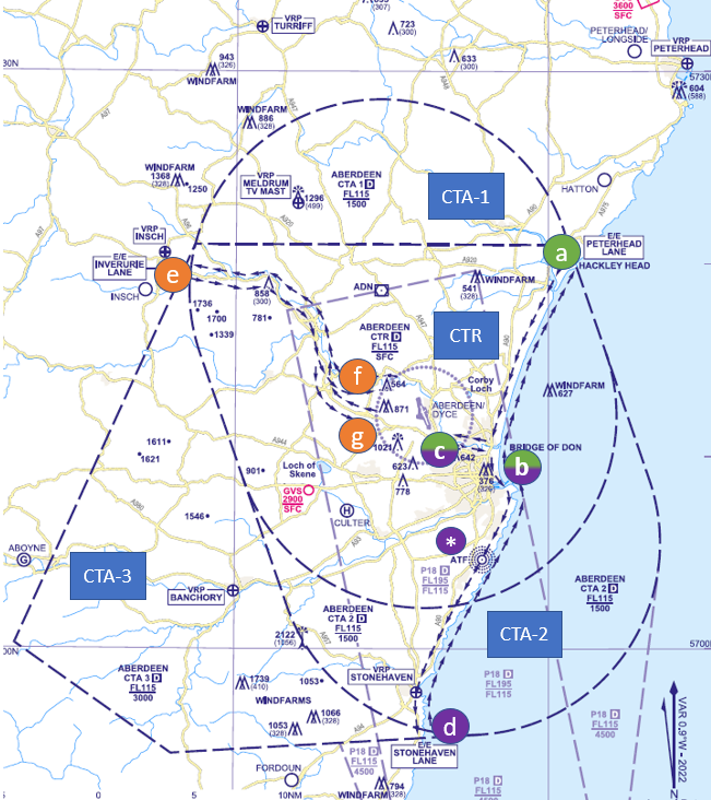
Figure 2: Aberdeen CTR and CTA
Entry and Exit Lanes
To facilitate the operation of aircraft to and from Aberdeen/ Dyce Airport, the following entry/exit lanes have been established for use under the stated conditions and subject to the provisions of the Air Traffic Control rules as stated at ENR 1.4 and are shown in Figure 1 above (letters referred to below).
Peterhead Lane is a lane, 3 NM wide, with its centre-line from Hackley Head (571949N 0015717W (point a on the Aberdeen CTR boundary) thence southwest along the coast to Bridge of Don (point b), then along the River Don to the point at which it crosses the Aberdeen Aerodrome Traffic Zone (point c);
Stonehaven Lane is a lane, 3 NM wide, with centre-line from 565522N 0021200W (point d on the Aberdeen CTA boundary) thence northeast along the coast to Bridge of Don (point b), then along the River Don to the point at which it crosses the Aberdeen Aerodrome Traffic Zone (point c). Pilots operating on this lane may observe model aircraft flying at ‘Haremoss’ position 570515N 0020912W (annotated *), approximately 1.5 NM northwest of Portlethen. Model aircraft not exceeding 13 KG in weight may be operated up to 400 feet AGL, daily, during daylight hours.
The Stonehaven Lane starts/finishes approximately two miles south of the town of Stonehaven.
Pilots must therefore ensure that they are complying with their clearance at this point.
Inverurie Lane is a lane 3 NM wide the with centre-line the Aberdeen/Inverness railway line extending from 571931N 0023510W (point e on the western boundary of the Aberdeen CTR) through Inverurie and Kintore to the point at which it crosses the Aberdeen Aerodrome Traffic Zone (point f). Additionally, for aircraft taking-off from Runway 16 or proceeding for a landing on Runway 34, a branch lane of similar width is established with centre-line the A96 road extending from Kintore to the point at which it crosses the Aberdeen Aerodrome Traffic Zone (point g).
In addition, pilots can also depart or arrive from the west and southwest routing via the Loch of Skene (6 NM southwest of Aberdeen Airport). Care should be taken when using this route in poor weather due to the proximity of high terrain.
Use of the lanes is subject to clearance being obtained from ATC Aberdeen, irrespective of prevailing weather conditions. This clearance is to be obtained by non-radio equipped aircraft before take-off and by radio equipped aircraft before entering the lane and subject to the following conditions:
- Aircraft using the lanes must remain clear of cloud and in sight of the ground or water, not above 2000 feet Aberdeen QNH (unless authorised by Aberdeen ATC).
- An aircraft using a lane shall keep the centreline on its left, unless otherwise instructed by ATC.
- Pilots of aircraft are responsible for maintaining adequate clearance from the ground or other obstructions.
- When Runway 34 is in use pilots, operating on the Stonehaven Lane, should expect an ATC clearance to route offshore not above 1000 feet when south of the Bridge of Don.
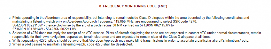
Figure 3
As part of the ANSP’s responsibilities, it is required to carry out post-occurrence analysis. One of the key findings from infringement occurrences could have been prevented or resolved in a timely manner had the pilot been using the Frequency Monitoring Code (FMC) process. In the Autumn of 2020, Aberdeen introduced an FMC using a squawk of 4270 and the associated frequency is Aberdeen Approach on 119.055 MHz. Rather than squawking 7000 or 2000 and operating autonomously, pilots are encouraged to use the FMC. The area in which the FMC should be used is published in the UK AIP in the aerodrome directory at EGPD AD2.22 (Figure 3)
This area is not subject to charting on the 1:250,000 and 1:500,000 VFR charts to reduce the amount of lines etc but is depicted on the chart at Figure 4.
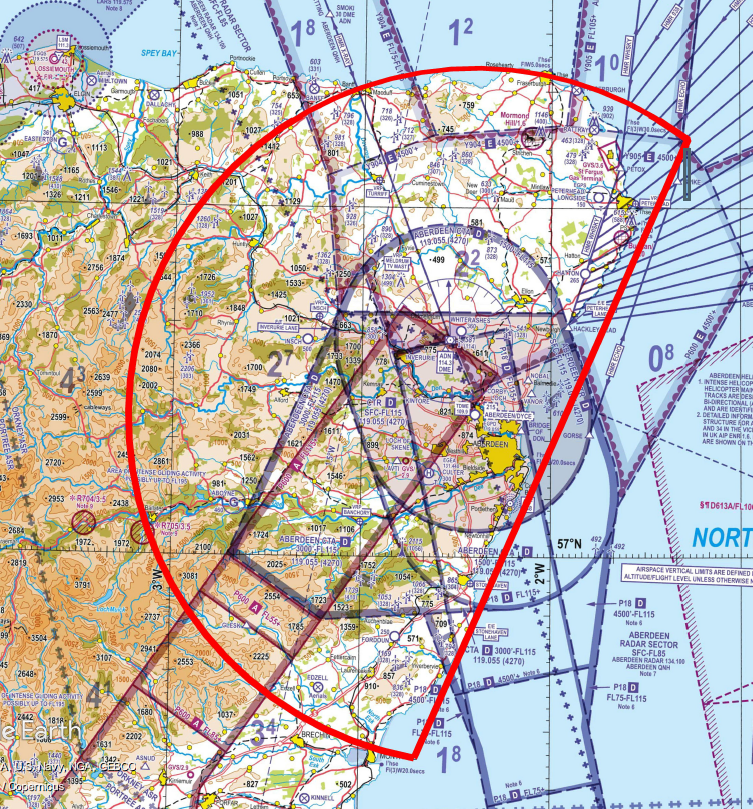
Figure 4
To use an FMC correctly, pilots should:
- select Aberdeen Approach frequency of 05 5MHz the radar controller’s radio frequency BEFORE selecting the appropriate FMC ensuring that the radio’s volume is turned up to a level that transmissions man be received and understood;
- select the squawk (Mode A) of 4270 using ALT (Mode C) if the transponder is so equipped;
- listen out for any transmissions with the aircraft’s callsign or position.
Note: Aberdeen’s Radar is Mode S equipped so if the aircraft is equipped with MODE S, the pilot will be issued a warning based on the aircraft’s registration/callsign. If the aircraft is not equipped with MODE S, the pilot will be issued with a warning based on the aircraft’s position.
More details on the use of FMC can be found in AIC Y085/2020 on the NATS AIS website, and in the UK AIP at ENR 1.6 section 2 (SSR) and at the chart at ENR 6-80.
Visual Reference Points
Aberdeen has 6 VRPs of which 2 are lie under the CTA and the remaining 4 lay outside the CTA/CTR complex.
| Name | Location | Features |
| Banchory | Under CTA-3
13.5 NM southwest of Aberdeen Airport |
Town on north side of bend in River Dee at confluence with River Feugh |
| Insch | 16 NM northwest of Aberdeen Airport | Small town with road and railway time on southern side. 2 NM northeast of Insch aerodrome. |
| Meldrum TV Mast | Under CTA-1
13 NM north northwest of Aberdeen Airport |
499 feet tall TV mast (extending to 1304 feet amsl) |
| Peterhead | 20 NM northeast of Aberdeen Airport | Town on east coast developed around Peterhead Bay bordered inland by A90 road with A950 road heading due west from town |
| Stonehaven | Under CTA-2
14 NM south of Aberdeen Airport |
Town on east coast bordered inland by A90 road |
| Turriff | 22 NM north northwest of Aberdeen Airport | Town to west of A947 road and to the east of River Deveron |
To help prevent an airspace infringement
As part of their pre-flight planning and in-flight execution, as well as using the Frequency Monitoring Code pilots are strongly encouraged to:
Use a Moving Map and, when able to, Take 2. The CAA actively encourages pilots to use VFR Moving Maps as part of their planning methodology, and when in flight, because they can enhance a pilot’s positional situational awareness and can also offer timely alerts to airspace and aviation hazards. However, Moving Map technology should not be the sole means of planning or navigation as highlighted in the European General Aviation Safety Team, Safety Promotion Leaflet, Using Advanced Navigation Technology Safely (EGAST GA7 page 3 refers).
If a Moving Map is used, then it should be in the pilot’s field of vision and have the appropriate airspace alarms/alerts turned on.
It is also important to remember that Moving Map APPs are not regulated by the CAA and users should note that their depiction of aeronautical information may be different to the UK Aeronautical Information products accessed via the NATS AIS website, such as VFR charts, the UK AIP and NOTAM information (NATS AIS is the authorised source of UK aeronautical information provided on behalf of, and regulated by, the CAA).
Make a Detailed Plan. Build in your climb and descent points when routing in the vicinity of multiple CTAs with differing base altitudes. Know what VRPs look like and what airspace lies above them or close by. Have a point beyond which you are not going to fly if you do not have a positive clearance to enter controlled airspace.
If appropriate – request a clearance at the earliest opportunity. If for any reason a climb is required above the base of the CTA, then a clearance must be obtained. Depending on a variety of factors, not least the runway in use and traffic situation at the time, this may well be available. By obtaining a clearance to enter controlled airspace when appropriate, ATC can control more effectively and ensure safety is maintained. An early clearance request reduces the potential to have to make a late airspace avoidance manoeuvre if the frequency is busy or a strong tailwind leaves less time to obtain the clearance from the same geographical point.
Do not fly on an RPS in the vicinity of the Aberdeen CTAs. The airspace lies within the Orkney Altimeter Setting Region but when flying on the RPS, as it is the forecast lowest QNH for a region, you will be higher in relation to the Aberdeen QNH. If you are receiving a FIS from Scottish Flight Information Service, and approaching the TMA, ask the FISO for the Aberdeen QNH or obtain the QNH from the ATIS at Aberdeen (121.855 MHz and on the VOR at 114.300 MHz), the Scottish VOLMET on 125.725 MHz.
Arrivals/Departures to the West or South West
When arriving/departing via Banchory VRP it is important to remember that CTA‐3 lies above the town, with a base altitude of 3000 feet. Pilots must remain below 3,000 feet unless they have received a clearance into CTA‐3. Note that if planning to route below CTA-2 to the east of Durris mast, this airspace has a base of 1500 feet.
Once clear of the CTR you may be informed by ATC that there is “no altitude restriction”. This means that there is no altitude restriction outside of controlled airspace. It does not mean that you may enter CTA‐3 (this will require an explicit clearance to enter the CTA).
If arriving from the west, be aware that CTA‐3 has a base of 3000 feet from just east of Aboyne. Using a ground track north of the town of Aboyne avoids both the Aboyne glider site and the high ground to the south of Aboyne.
If poor weather conditions over the hills to the west require an unplanned deviation towards Aberdeen controlled airspace, Aberdeen Approach will be able to provide pilots with information on the airspace in their vicinity.
Arrivals/Departures to the North
The northerly extent of CTA‐1 is the 10 DME arc from the ADN. Pilots may find it helpful to tune their DME to 114.300 or use their moving map display to identify the boundary of CTA‐1. The base of CTA-1 is 1500 feet with aircraft under vectors for an instrument approach to Runway 16 within this CTA.
Local Airspace Infringement Teams (LAIT), Air Navigation Service Providers (ANSP) and the Military Aviation Authority (MAA) have produced these narratives to help pilots avoid infringing airspace at known hot-spots around the UK.
Each narrative has been written based on the Threats and potential Errors that we can all be exposed to in the course of our flying, recreationally, during training or during the course of business operations.
As well as identifying the specific hot-spots, the narratives include information to increase our knowledge-base and guidance from safety partners involved in helping pilots prevent airspace infringements.
Preventing infringements of the Pendine Danger Area (EG D117)
NEW – November 2022
This infringement update is the 32nd in a series of narratives focusing on identified infringement ‘hot-spots’ in the UK. It has been written by the Military Aviation Authority (MAA) and members of the CAA’s Airspace Infringement Team following a number of occurrences.
Ministry of Defence (MOD) Pendine is located on the southwest coast of Wales. The presence of a military range at Pendine dates back to 1940 and it has been in constant use ever since. The range is used by the MOD and defence contractors for a number of activities that can be hazardous to aviation including the use of ordnance, munitions and explosives, high-energy manoeuvres by military aircraft and the operation of unmanned aircraft system (UAS) operating within visual line of sight. In addition to the obvious hazards associate with activities, the area is used for activities that may pose electronic and or optical hazards.
The danger area is situated in Pendine and has a land area of 20.5km². It has 9km of shoreline that has been used in the past for aircraft landing training sorties, while the large sea danger area stretches over approximately 18km². It also has an air danger area which can extends up to up to 27,000 feet Above Mean Sea Level (AMSL). The airspace is restricted and therefore pilots of all aircraft types, including microlights and paragliders, must familiarise themselves with the restrictions for their safety and that of others.
Unlike Pembrey Sands (EG D118), the danger area does not provide air traffic control facilities and instead polices its airspace through the use of land wardens, observers and liaison with other Air Navigation Service Providers. The area is notified in the United Kingdom Aeronautical Information Publication (UK AIP) in the En-route section at ENR 5.1 from surface to 23,000 feet AMSL but may, occasionally be active up to 27,000 feet AMSL (Figure 1). In addition, the UK AIP entry informs pilots that:
- A Danger Area Activity Information Service (DAAIS) is available from London Information on 124.750 MHz.
- Pre-flight information can be obtained from Pendine Range Control on 01994-452240
- The danger area’s hours of activation are notified by NOTAM
Figure 1 – Correct at AIRAC 10/2022
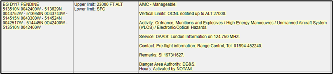
Figure 1 United Kingdom Aeronautical Information Publication (UK AIP)
When reviewing the VFR chart (Figure 2), the following is depicted:
- Broken boundary line denoted the danger area is activated by NOTAM;
- 23.0 denotes the upper limit is 23,000 feet AMSL;
- OCNL /↑27.0 denotes that the upper limit can be occasionally notified to 27,000 feet AMSL;
- § denote that a DAAIS is available;
- ¶ denotes that pre-flight information is available from the telephone number contained in the relevant chart legend; and
- * denotes that a byelaw prohibits entry during the period of activity.
Figure 2 – Correct at Sheet 2171CD Edition 48 (2022)
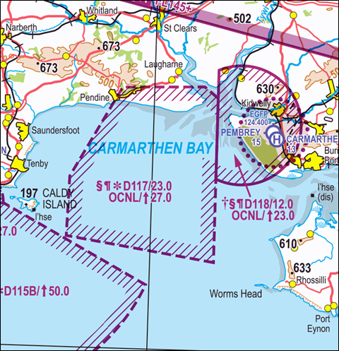
Figure 2 VFR chart
An example of an activation NOTAM is at Figure 3a with the decoded NOTAM at Figure 3b.
Figure 3a NOTAM M4209/22
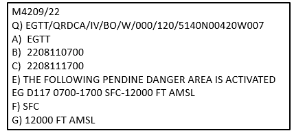
Figure 3a NOTAM M4209/22
Figure 3b NOTAM M4209/22 decoded
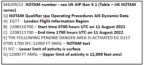
Figure 3b NOTAM M4209/22 decoded
Pembrey Sands (EG D118)
Adjacent and to the east of Pendine is MOD Pembrey Sands (EG D118). Pembrey Sands is an Air Weapons Range used by both fixed-wing, unmanned air systems and rotary-wing aircraft for live firing and high energy manoeuvres. The airspace for Pembrey Sands extends up to 23,000 feet AMSL and the aircraft operating within it are controlled by air traffic control. It is important to note that pilots obtaining a clearance to cross Pembrey Sands are not cleared to also cross Pendine as the control authorities are different and a separate clearance must be obtained. The UK AIP entry informs pilots that:
- A Danger Area Crossing Service / DAAIS is available through Pembrey Range on 122.750 MHz when open; at other times London Information on 124.750 MHz.
- Pre-flight information / Booking is available by contacting Range ATC, Tel: 01554-892205
Avoiding Airspace Infringements
Crossing a danger area without permission is extremely hazardous and puts lives at risk.
Recent analysis of infringements of EG D117 indicate two MAIN factors underpin the majority of occurrences:
- A deviation to the south from a planned route over land resulting from encountering weather which could have been anticipated had a comprehensive meteorological brief been carried out pre-flight. As a result of the lack of a contingency plan (a Plan B), the status of EG D117 was unknown.
- A lack of situational awareness as to the status of EG D117 when planning to route along the South Wales coast and through the danger area due to lapses in pre-flight planning.
The ASI would like to remind pilots of the importance of carrying out focused and unhurried pre-flight planning considering all aspects of flight, from pre-flight preparation to how you will depart the aerodrome, the en-route phase to the correct procedures to be flown at the destination aerodrome. This planning must be based on the use of regulated aeronautical information products from the NATS Aeronautical Information Service such as the most appropriate VFR charts and the UK AIP and the UK Met Office Aviation Briefing Service.
Use a VFR Moving Map. In causal factor analysis, the correct use of VFR Moving Map technology could have prevented 85% of analysed airspace infringements from occurring. Based on these statistics the CAA actively encourages pilots to use VFR Moving Maps as part of their planning and when in flight, because they can enhance a pilot’s positional situational awareness and can also offer timely alerts to airspace and aviation hazards. However, Moving Map technology should not be the sole means of planning or navigation as highlighted in the European General Aviation Safety Team, Safety Promotion Leaflet, Using Advanced Navigation Technology Safely (EGAST GA7 page 3 refers).
When using VFR Moving Maps, it is also important to remember that Moving Map APPs are not regulated by the CAA the depiction of danger area (and other) aeronautical information on VFR Moving Maps may be different to that on the UK Aeronautical Information products accessed via the NATS AIS website, such as VFR charts, the UK AIP and NOTAM information (NATS AIS is the authorised source of UK aeronautical information provided on behalf of, and regulated by, the CAA).
Plan ahead and have a contingency plan (Plan B). There are many ways in which to obtain the status of EG D117 as noted above. It is imperative that you know and use the official sources of information if you are flying in the area even if your plan is not to fly proximate to EG D117. Have a backup plan should your primary plan not be achievable. This may involve re-routing or holding within the local area, being careful of other airspace in the vicinity.
Understand the difference between a DAAIS and a DACS – A Danger Area Activity Information Service (DAAIS) is provided to enable a pilot to obtain, via a Nominated Air Traffic Service Unit (NATSU), an airborne update of the activity status of a participating danger area whose position is relevant to the flight of the aircraft. It is strongly emphasised that information obtained from a NATSU is only pertinent to the ACTIVITY STATUS of a danger area and is NOT a clearance to cross that danger area, whether or not it is active. Such an update will assist pilots in deciding whether it would be safe to penetrate the (inactive) area. The DAAIS does not absolve pilots from the responsibility of obtaining as much information as possible on a relevant danger area by existing methods of notification, as part of normal pre-flight briefing procedures. Pilots are advised to assume that a danger area is active, even if no reply is received from the appropriate NATSU, and pilots should AVOID the area.
A Danger Area Crossing Service (DACS) contact frequencies can be found in the official VFR Chart legend and the availability of their services in the UK AIP ENR 5.1. Pilots should call on the published frequency when approaching a danger area to request a clearance prior to entry. The DACS Unit will, when the DA activity permits, provide a clearance for an aircraft to cross the DA under a suitable type of service. It should be noted that, dependent on the activity, it may not be possible to accommodate a crossing of a danger area during its notified hours of operation. When a DACS is available, the danger area is annotated on the chart with a dagger symbol: †
The crossing clearance is only in relation to danger area activity. The provision of deconfliction advice and/or traffic information in relation to other traffic, either inside or operating close to the DA, will be in accordance with the scope of the specific Air Traffic Service provided, i.e. Deconfliction Service, Traffic Service or Basic Service. Where possible, the pilot should provide the DACS Unit with an estimated crossing time. When used by a DACS Unit, the term ‘active’ means that the danger area is notified as active and there is activity taking place. Where there is no possibility of confusion, the number of the danger area may be replaced by the name, eg. ‘Danger Area Loudwater’.
Reference material
- United Kingdom Aeronautical Information Package – NATS UK | AIP (ead-it.com)
- Pre-flight planning – Read Airspace Safety Initiative Pre-flight planning
- Threat and Error Management – Read Airspace Safety Initiative Threat and Error Management
- European General Aviation Safety Team, Safety Promotion Leaflet (EGAST) GA7 -Using Advanced Navigation Technology Safely – Read EGAST GA7
- Using VFR Moving Map Devices – Read CAA Safety Sense 29: VFR Moving Map Devices
Preventing airspace infringements in the vicinity of Newcastle Airport
January 2023
This infringement narrative is number 33 in a series of narratives that are issued focusing on identified infringement ‘hot-spots’ in the UK. The aim is to provide pilots operating in the area with useful information on airspace and infringement prevention practices. This narrative has been produced by the Air Traffic Service Unit at Newcastle Airport. In 2022, the airspace was infringed 12 times: six times by microlights, three by military aircraft, twice by single engine propeller aircraft and once by a helicopter.
The Airport
Newcastle Airport (EGNT) is a busy international airport open H24 with two runways (oriented 07/25) which, pre COVID-19 pandemic, was serving over 5 million passengers per year with over 50,000 annual movements. In addition to its worldwide passenger services, it provides freight and mail services to domestic and international destinations.
The Airspace
The Newcastle airspace is relatively simple in construct and lies at the confluence of 2 higher level CTA into and out of the Newcastle CTA and CTR (Figure 1).
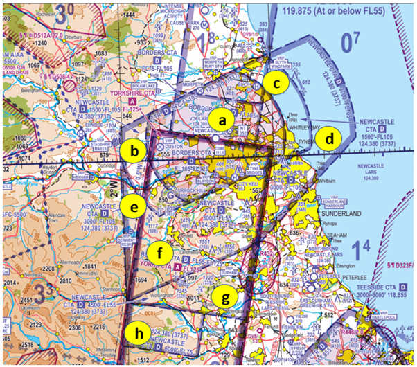
Figure 1: Correct at Sheet 2171AB Northern England and Northern Ireland Edition 45 (2022)
The airspace comprises one CTR and 7 CTAs (all Class D with the bases notified on the Newcastle QNH) as follows (chart annotations on figures 1 and 2 relate to the list below):
| a | CTR | Surface – FL105 | |
| b | CTA-1 | 1,500 feet AMSL – FL105 | |
| c | CTA -2 | 1,500 feet AMSL – FL105 | |
| d | CTA-3 | 3,000 feet AMSL – FL105 | |
| e | CTA-4 | 3,000 feet AMSL – FL105 | |
| f | CTA-5 | 3,000 feet AMSL – FL55 | Underneath Borders CTA (FL 55-FL 125) and Yorkshire CTA (FL125 +) |
| g | CTA-6 | 4,500 feet AMSL – FL55 | Underneath Borders CTA (FL 55-FL 125) and Yorkshire CTA (FL125 +) |
| h | CTA-7 | 6,000 feet AMSL – FL75 | Underneath Borders CTA (FL 75-FL 125) and Yorkshire CTA (FL125 +) |
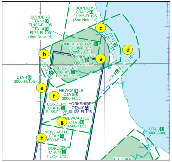
Figure 2:Correct at AIRAC 11/2022
The Class D Borders CTA and Class A & D Yorkshire CTA provides connectivity to the north and south.
Visual Reference Points (VRPs)
Newcastle has 11 VRPs of which three are within the CTR, three are under CTA and the remaining five are outside the CTA/CTR complex. The table below details the 11 VRPs and the airspace in which they lay (numbers relate to figure 4). Routes have been established for use by aircraft inbound to or outbound from Newcastle Airport operating under VFR determined by one or more of the VRPs depending on the runway in use. These routes are published in the UK Aerodrome Directory (AD) EGNT AD 2.22 (Flight Procedures) paragraph 4.
| Name | Location | Features | |
| Inside the CTR | |||
| 1 | Blaydon | Within the CTR and approximately 4.25 NM south of EGNT | Curve in the route of the River Tyne at Blaydon |
| 2 | Ouston (Disused Aerodrome) | Approximately 6.5NM west of EGNT, to the left of the final approach to Runway 07. | A 6-runway disused WWII aerodrome with a domestic site on the southern boundary. |
| 3 | Tyne Bridges | Within CTR and approximately 5NM south southeast of EGNT | Eastern set of 5 bridges over River Tyne |
| Underneath a CTA | |||
| 4 | Blyth Windfarm | Under CTA-2, 9NM northeast of EGNT | Windfarm at Blyth Harbour |
| 5 | Derwent Reservoir | Under CTA-4 approximately 14NM southwest of EGNT | Major reservoir west of Consett |
| 6 | Morpeth Railway Station | Approximately 7.5NM north of EGNT and close to the edge of the CTR and underneath the Borders CTA (base FL155) | Railway station in the centre of Morpeth 1.5NM east of the A1 bypass around town |
| Laterally clear of controlled airspace | |||
| 7 | Bolam Lake | Outside controlled airspace approximately 9NM northwest of EGNT | Lake with woodland to north and west |
| 8 | Durham | Outside controlled airspace 18 NM south southeast of EGNT | Durham Cathedral |
| 9 | Hexham | Outside controlled airspace 17 NM west southwest of EGNT | Abbey in town which is immediately south of the River Tyne and A69 |
| 10 | Stagshaw Masts | 11.5NM west of EGNT and close to the western edge of the CTA-1 | 485 feet agl masts to the east of the A68 |
| 11 | Sunderland Harbour | 13.5NM southeast of EGNT and close to edge of CTA-3 | Harbour |
Frequency Monitoring Code (FMC)
The ability to resolve airspace infringements in a timely manner is severely limited when pilots either operate autonomously on a 7000 or 2000 squawk or are in communication with London or Scottish Information. It has been found that when operating proximate to controlled airspace and not requiring a radar service, the use of the relevant Frequency Monitoring Code (FMC) has enabled prompt resolution to an occurrence; when controller capacity exits, the application of defensive controlling techniques may allow controllers to warn a pilot of an infringement before it occurs. The area in which the Newcastle FMC (Mode A 3737) should be used is published in the UK AIP in the aerodrome directory at EGNT AD 2.22 (Figure 3). This area is not subject to charting on the 1:250,000 and 1:500,000 VFR charts to reduce chart clutter but is depicted on the chart extract at Figure 4.
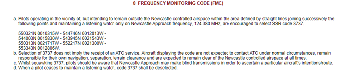
Figure 3: Correct at AIRAC 11/2022
Figure 4: Correct at Sheet 2171AB Northern England and Northern Ireland Edition 45 (2022)
To use an FMC correctly, pilots should:
- select Newcastle Radar frequency of 124.380 MHz (the radar controller’s radio frequency) BEFORE selecting the appropriate FMC ensuring that the radio’s volume is turned up to a level that transmissions may be received and understood;
- select the squawk (Mode A) of 3737 using ALT (Mode C) if the transponder is so equipped;
- listen out for any transmissions with the aircraft’s callsign or position.Note: Newcastle Air Traffic Control’s Radar is Mode S equipped so if the aircraft is equipped with MODE S, the pilot will be issued a warning based on the aircraft’s registration/callsign. If the aircraft is not equipped with MODE S, the pilot will be issued with a warning based on the aircraft’s position.
More details on the use of FMC can be found in AIC Y100/2022 on the NATS AIS website, and in the UK AIP at ENR 1.6 section 2 (SSR) and at the chart at ENR 6-80
Pre-flight planning and in-flight execution
To prevent an airspace infringement, as part of their pre-flight planning and in-flight execution, as well as using the Frequency Monitoring Code pilots are strongly encouraged to:
Use a Moving Map. The CAA actively encourages pilots to use VFR Moving Maps as part of their planning methodology and when in flight. They can enhance a pilot’s positional situational awareness and can also offer timely alerts to airspace and aviation hazards. However, VFR Moving Map technology should not be the sole means of planning or navigation as highlighted in the European General Aviation Safety Team, Safety Promotion Leaflet, Using Advanced Navigation Technology Safely (EGAST GA7 page 3 refers).
If a VFR Moving Map is used, then it should be in the pilot’s field of vision and have the appropriate
airspace alarms/alerts turned on. It is also important to remember that VFR Moving Map APPs are not regulated by the CAA and users should note that their depiction of aeronautical information may be different to the UK Aeronautical Information products accessed via the NATS AIS website, such as VFR charts, the UK AIP and NOTAM information (NATS AIS is the authorised source of UK aeronautical information provided on behalf of, and regulated by, the CAA).
Make a Detailed Plan. Consider where you want to route and what you might want to see en-route:
- Where able, plan to Take 2 by remaining at least 2NM from the edge or 200 feet below the base of the subject airspace to avoid airspace infringements. The recommended 200 feet distance may need to be increased during flights where turbulence or thermic conditions are encountered to prevent inadvertent climbs into controlled airspace.
- When flying a route that requires changes in altitude due to, for example CTAs, it is good practice to annotate on your chart climb and descent points that take into consideration the requirements of the airspace as well as incorporating the ‘Take 2’ guidance. These points should then be noted on your PLOG and added as separate waypoints on your VFR Moving Map device to act as triggers.
- Know what VRPs look like and what airspace lies above them or close by. Have a point beyond which you are not going to fly if you do not have a positive clearance to enter controlled airspace.
- As part of your plan, develop a robust communication plan that includes who you will communicate with and when (based on the Designated Operational Coverage [DOC])
If appropriate – request a clearance at the earliest opportunity. If, for any reason, a climb is required above the base of the CTA, then a clearance must be obtained. Depending on a variety of factors, not least the runway in use and traffic situation at the time, this may well be available. By obtaining a clearance to enter controlled airspace when appropriate, ATC can control more effectively and ensure safety is maintained. An early clearance request reduces the potential to have to make a late airspace avoidance manoeuvre if the frequency is busy or a strong tailwind leaves less time to obtain the clearance from the same geographical point.
Do not fly on a Regional Pressure Setting (RPS) in the vicinity of the Newcastle Controlled Airspace. The airspace lies within the Tyne Altimeter Setting Region but when flying on the RPS, as it is the forecast lowest QNH for a region, you will be higher in relation to the Newcastle QNH. If you are receiving a FIS from London or Scottish Flight Information Service and approaching Newcastle, ask the FISO for the Newcastle QNH or obtain the QNH from the Newcastle ATIS (118.380 MHz) or on the London VOLMET (North) on 126.600 MHz. Pilots are, however, recommended to obtain a service from Newcastle Radar on 124.380 MHz or use the Newcastle FMC when flying proximate to its controlled airspace.
Related information
Preventing airspace infringements in the vicinity of Coventry aerodrome
February 2023
The Midlands LAIT has noted a significant ‘hot-spot’ exists for airspace infringements of the Birmingham Control Area (CTA-2) in the vicinity of, and in particular, to the southwest of Coventry Aerodrome Traffic Zone (ATZ). In 2022, Birmingham statistics show that a total of 31 infringements have occurred, 20 of which have been infringements of CTA-2. Of all total infringements, 28% have involved aircraft either inbound to, or outbound from, Coventry aerodrome. A plot of the locations of the infringements are at Figure 1.
Figure 1 Infringement locations
Coventry Aerodrome
Coventry is located approximately 11NM east southeast of Birmingham airport. The ATZ lies within the lateral confines of the following three volumes of Birmingham controlled airspace and extends to 2,000 feet agl (2,267 feet amsl):
- CTA-2: Class D, 1,500 feet – 4,500 feet amsl.
- CTA-4: Class D, 3,500 feet – 4,500 feet amsl.
- CTA-8: Class D, 2,000 feet – 4,500 feet amsl.
Coventry’s runways are oriented 05/23 and circuits will normally be flown to the south of the aerodrome (right hand circuit Runway 05, left hand circuit Runway 23). Circuit height for fixed wing aircraft is 1,000 feet above aerodrome level (aal) (1,267 feet amsl) and helicopter circuit height is 700 feet aal (967 feet amsl).
The portion of Coventry’s ATZ inside the Birmingham CTA is under the direct control of Birmingham ATC and not Coventry Flight Information Service Unit. You will need clearance from Birmingham ATC in order to enter their controlled airspace, otherwise you must remain below 1,500 feet amsl when operating beneath CTA-2, below 2,000 feet amsl when operating beneath CTA-8 and below 3,500 feet amsl when operating beneath CTA-4 inside Coventry ATZ (Figure 2).
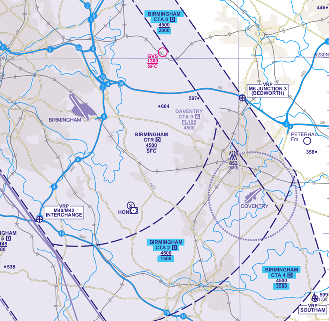
Figure 2
Visual Reference Points (VRPs)
Coventry has three VRPs highlighted in Figure 3:
- Southam VRP lies within Class G airspace approximately 6.7NM southeast of Coventry aerodrome. Pilots must remain aware that Birmingham CTA-4 is situated northwest of the VRP where the base of controlled airspace is 3,500 feet amsl.
- Draycote Water VRP lies in Class G airspace approximately 6.2NM east southeast of Coventry aerodrome. Pilots must remain aware that Birmingham CTA-4 is situated approximately 1NM to the west of the VRP where the base of controlled airspace is 3,500 feet amsl.
- Nuneaton Disused Aerodrome VRP lies in Class G airspace approximately 11.7NM north of Coventry aerodrome. Pilots must remain aware that Birmingham CTA-8 is situated to the southwest of the VRP where the base of controlled airspace is 2,000 feet amsl.
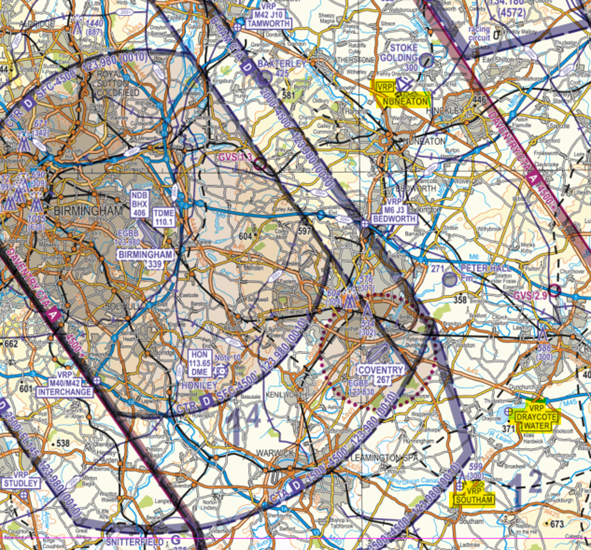
Figure 3 – Correct at Sheet 5 Central England and Wales Edition 14 (2021)
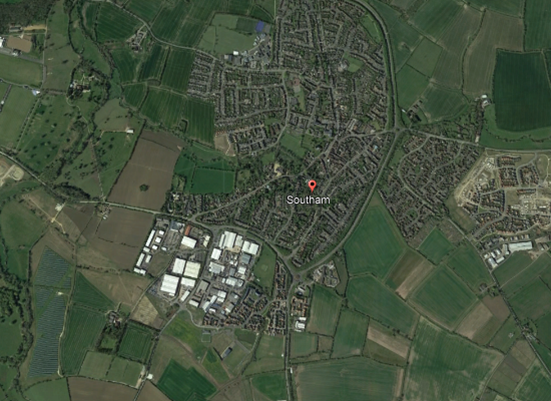
Southam VRP
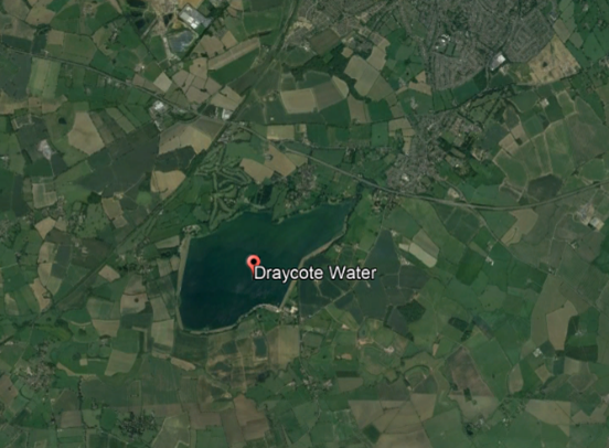
Draycote Water VRP
Arriving and Departing Coventry Aerodrome
Arrivals VFR
Overhead joins are not permitted due to the close proximity of Birmingham CTA-2. Straight in approaches are available on request, giving way to circuit traffic as appropriate.
Runway 23: Route to Draycote Water VRP and join on left base giving way to circuit traffic as appropriate.
Runway 05: Route to Southam VRP and join on right base giving way to circuit traffic as appropriate.
Departures VFR
On departure, Coventry Information will provide the QNH rather than the QFE due to the close proximity of Birmingham CTA-2. There are no defined departure procedures however it is recommended that:
Runway 23: Turn crosswind and route to Southam VRP.
Runway 05: Turn crosswind and route to Draycote Water VRP.
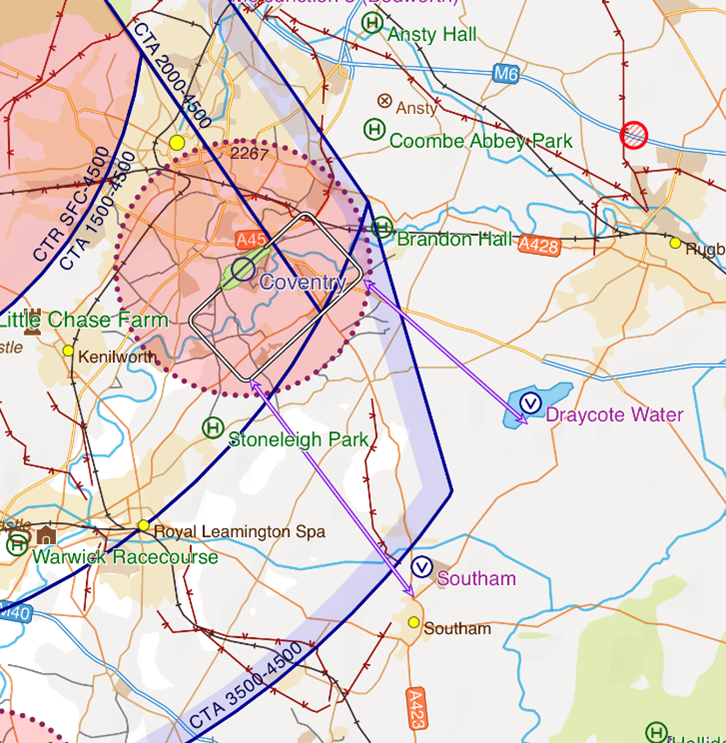
Separation Standards against an Unknown Aircraft
Birmingham Air Traffic Control (ATC) is required to provide a minimum separation of 5NM laterally or 5,000 feet vertically against all unknown aircraft. If an aircraft infringes any part of the Birmingham controlled airspace structure, air traffic controllers need to maintain this separation between the infringing aircraft and all IFR aircraft inbound to, or outbound from, Birmingham Airport.
For more information on the impacts that an infringing aircraft has on the arrivals and departures into Birmingham Airport, please refer to narrative number 03. Birmingham CTA-2 hot-spot narrative.
Frequencies
Coventry Information frequency is 123.830MHz and has a Designated Operational Coverage (DOC) of 20NM radius and up to 6,000 feet amsl.
Birmingham Radar frequency is 123.980MHz and has a DOC of 40NM radius and up to FL200.
Where possible, pilots should plan to call Coventry Information approximately 10NM from the airfield. On first contact, the pilot will be informed of runway in use, QNH, issued with a squawk (0420) and reminded to remain outside and below controlled airspace. Calling Coventry Information approximately 10NM from the airfield will allow sufficient time to pass airfield information and local traffic information to enable pilots to integrate with any circuit traffic.
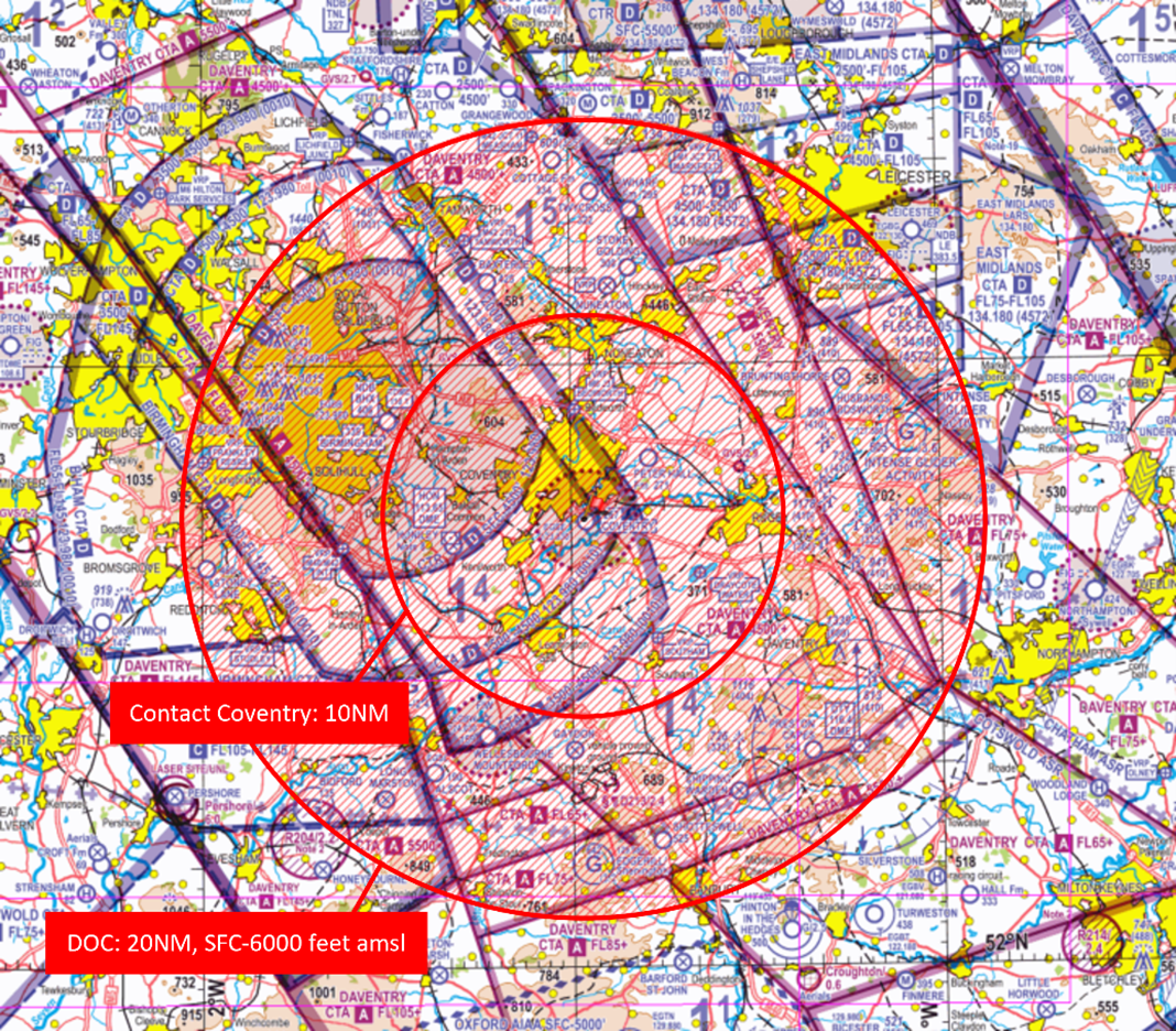
Figure 4 – Correct at Sheet 5 Central England and Wales Edition 14 (2021)
To prevent airspace infringements Coventry will issue the Coventry QNH rather than the QFE to inbound/outbound aircraft. The QFE can be requested, however pilots must be aware of the close proximity to Birmingham CTA-2 where the base of controlled airspace is 1,500 feet amsl. With an aerodrome elevation of 267 feet and the low-lying CTA-2 (based on the Birmingham QNH) above, pilots must be aware of the possibility of an inadvertent infringement when operating on the QFE in a high workload environment. For example, if an aircraft departing runway 23 climbed to 1300 feet on the QFE inside Coventry ATZ, it would be at 1567 feet QNH, thereby infringing CTA-2.
Pilots routing around the Coventry ATZ/through the runway approaches for Coventry are encouraged to contact Coventry Information on 123.830 MHz for a basic service and may find it useful to obtain relevant traffic information.
Pilots flying in the vicinity of but remaining outside of Birmingham controlled airspace and remaining distant from Coventry ATZ are encouraged to make use of the Birmingham Frequency Monitoring Code (FMC). Selection of 0010 does not imply receipt of an Air Traffic Service (ATS) but allows a pilot to listen out and be aware of any aircraft in their vicinity. Traffic operating on the Birmingham FMC of 0010 squawk will not be passed traffic information relating to aircraft into/outbound from Coventry by Birmingham Radar. The FMC does not provide clearance to enter controlled airspace, a pilot must call Birmingham Radar and request this.
Preventing an Airspace Infringement
To prevent an airspace infringement, as part of their pre-flight planning and in-flight execution, pilots are strongly encouraged to:
- Use a VFR Moving Map to provide a profile along your planned route showing controlled airspace above and below your route. Insert waypoints to show descent and climb points that are built into your plan, incorporating Take 2 wherever possible and enable airspace warnings to help identify airspace when in close proximity.
- Use the correct QNH. When arriving and departing Coventry, pilots should ensure they have the Coventry QNH selected and not the QFE due to the close proximity to Birmingham CTA-2.
- Make a detailed plan. Build in your climb and descent points when routing in the vicinity of multiple CTAs with differing base altitudes. Know what VRPs look like and what airspace lies above them or close by. Have a point beyond which you are not going to fly if you do not have a clearance to enter controlled airspace.
- If appropriate – request a clearance. If for any reason a climb is required above the base of the CTA, then a clearance must be obtained. Depending on a variety of factors, not least the runway in use and traffic situation at the time, this may well be available. By obtaining a clearance to enter controlled airspace when appropriate, ATC is able to control more effectively and ensure safety is maintained.
- Use a Frequency Monitor code (FMC). Rather than squawking 7000/2000, if you do not want to obtain a service from Birmingham ATC, use a Frequency Monitoring Code by squawking 0010 and monitoring 123.980MHz.
Infringement statistics analysis has identified a trend in infringements of Stansted airspace. This hot-spot narrative is the first in a series covering satellite airfields around Stansted controlled airspace. It is intended to provide guidance to help pilots visiting Hunsdon prevent airspace infringements.
DOWNLOAD Hunsdon Area of Operation A5 card
Hunsdon Microlight Site is located at 51’48’25°N 000’04’16°E, inside the south-western edge of the Class D Stansted Control Zone (CTR) approximately 7.5 NM from London Stansted Airport on a bearing of 232°. The site is adjacent to the Stansted Transponder Mandatory Zone (TMZ-2) and has an Area of Operation (AoO) which is established to facilitate flight within TMZ-2 for aircraft unable to comply, and flights into and out of Hunsdon without a specific class D entry clearance from Stansted Radar.
Chart extract from 1:500k Sheet 2171CD SOUTHERN ENGLAND AND WALES Edition 49 (2023)
Note: Hunsdon location is corrected in UK AIP ENR 5.5 to depict inside the Stansted CTR as of AIRAC 03/2023
Stansted controlled airspace structures
Hot-spot narrative 16: Stansted CTA, CTR and TMZs provides a detailed article on preventing airspace infringements of the controlled airspace structures in the vicinity of Stansted Airport.
Hunsdon is located within the Class D Stansted CTR, active surface to 3500 feet AMSL. Stansted has four Class D Control Areas:
- CTA-1 to the north-east
- CTA-2 to the south-west
- CTA-3 to the east/south-east
- CTA-4 to the west/north-west
In 2009, two TMZs were established which are co-incident with the lateral confines of CTA-1 and CTA-2; they sit underneath the CTAs from surface to 1500 feet AMSL. Luton CTA-1 is located to the north-west of Hunsdon.
Operating inside any TMZ, without ATC approval, requires a serviceable Mode-S elementary transponder to be always operated to its full operating capacity. This requirement is is notified in the United Kingdom Aeronautical Information Publication (AIP) at Gen 1.5 (GEN 1.5 AIRCRAFT INSTRUMENTS, EQUIPMENT AND FLIGHT DOCUMENTS).
Access to a TMZ can still be granted without a serviceable Mode-S transponder subject to ATC approval. Details on how to access Stansted TMZs without a serviceable Mode-S transponder can be found in the next section.
Chart extract showing airspace structures
| Structure | Airspace Class | Level (AMSL) | |
| 1 | Stansted CTR | D | Surface – 3500 feet |
| 2 | Stansted CTA-1 | D | 1500 feet – 3500 feet |
| 3 | Stansted CTA-2 | D | 1500 feet – 2500 feet |
| 4 | Stansted CTA-3 | D | 2500 feet – 3500 feet |
| 5 | Stansted CTA-4 | D | 2500 feet – 3500 feet |
| 6 | Stansted TMZ 1 | G | Surface – 1500 feet |
| 7 | Stansted TMZ-2 | G | Surface – 1500 feet |
| 8 | Luton CTA-1 | D | 2500 feet – 3500 feet |
Further information can be found within UK AIP EGSS AD 2.17.
Hunsdon procedures
Hunsdon is strictly a PPR airfield. It is a condition of the Stansted-Hunsdon Letter of Agreement that all visiting pilots must obtain a PPR brief over the telephone from a Hunsdon club officer, contact details can be found on the club website.
The AoO is established up to an altitude of 1000 feet AMSL to enable aircraft to operate into and out of the site without a specific Class-D entry clearance. In addition, the AoO allows flight within the TMZ without the requirement to operate a Mode-S transponder.
The AoO dimensions can be found in UK AIP EGSS AD 2.22.8.
Prior to departure
Ensure you have made a detailed plan, are familiar with the Hunsdon Circuit reference points and squawk 7010 if able.
Inbound and outbound procedures
Pilots operating into and out of Hunsdon should make transmissions on the SafetyCom frequency 135.480MHz, with calls made in accordance with CAP 413, prefixed “Hunsdon Microlight Traffic” and suffixed “Hunsdon”.
All Hunsdon aircraft must remain inside the AoO when operating inside the Stansted CTR. Pilots of aircraft equipped with a serviceable mode-S transponder can plan a route through TMZ-2 of their choice. Squawk 7010 when arriving and departing to allow Stansted Radar to know your intentions at Hunsdon.
All aircraft should operate on the Stansted QNH which is obtained from Stansted ATIS on 127.175 MHZ.
Operating without a Mode-S transponder
Aircraft that are not equipped with a Mode-S transponder must adhere to one of the following two options when inside TMZ-2:
- Route via the Hunsdon AoO; or
- Obtain a permission from either:
-
- Farnborough Radar on 132.800 MHz between 0800 hours and 2000 hours UTC; or
- Stansted Radar on 120.625 MHz at other times.
Aircraft wishing to operate within the TMZ, outside of the AoO, must gain specific ATC approval to transit the TMZ.
A TMZ permission is not required for aircraft routeing solely within the AoO. Entry and exit to the AoO and the surrounding Class G airspace is north of Visual Reference Point (VRP) Ware and south of the village of High Cross. To remain inside the AoO, pilots are advised to remain northeast of the water at Stansted Abbotts and west of the electricity pylons.
Further information on operating inside Stansted TMZs can be found in this leaflet: Stansted TMZ
The procedures for Farnborough Radar to co-ordinate the request with Stansted Radar may result in a short delay for a permission to be granted which should be taken into consideration at the pre-flight planning stage.
Hunsdon moving map
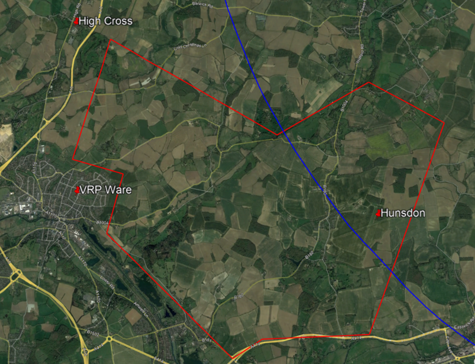
Hunsdon AoO
Circuit Procedures
Aircraft operating at Hunsdon should do so on the Stansted QNH as the AOO ceiling is 1000 feet AMSL on the Stansted QNH. It is recommended to apply the ‘Take 2’ guidance – remain 200 feet below the base of controlled airspace.
Pilots should be aware of the circuit reference points, highlighted on the chart below in yellow:
- Hunsdon Farm Lodge (1) to the west,
- Tuck’s Spring (2) to the southeast,
- Powerlines (3) to the east and
- Marshland Wood (4) to the north.
Due to the constrained nature of some circuit patterns, pilots of high-performance microlights may find some circuits for 08 and 32 challenging and training circuits by non-club students are not permitted. Glide descents are preferred where it is safe and practicable to do so.
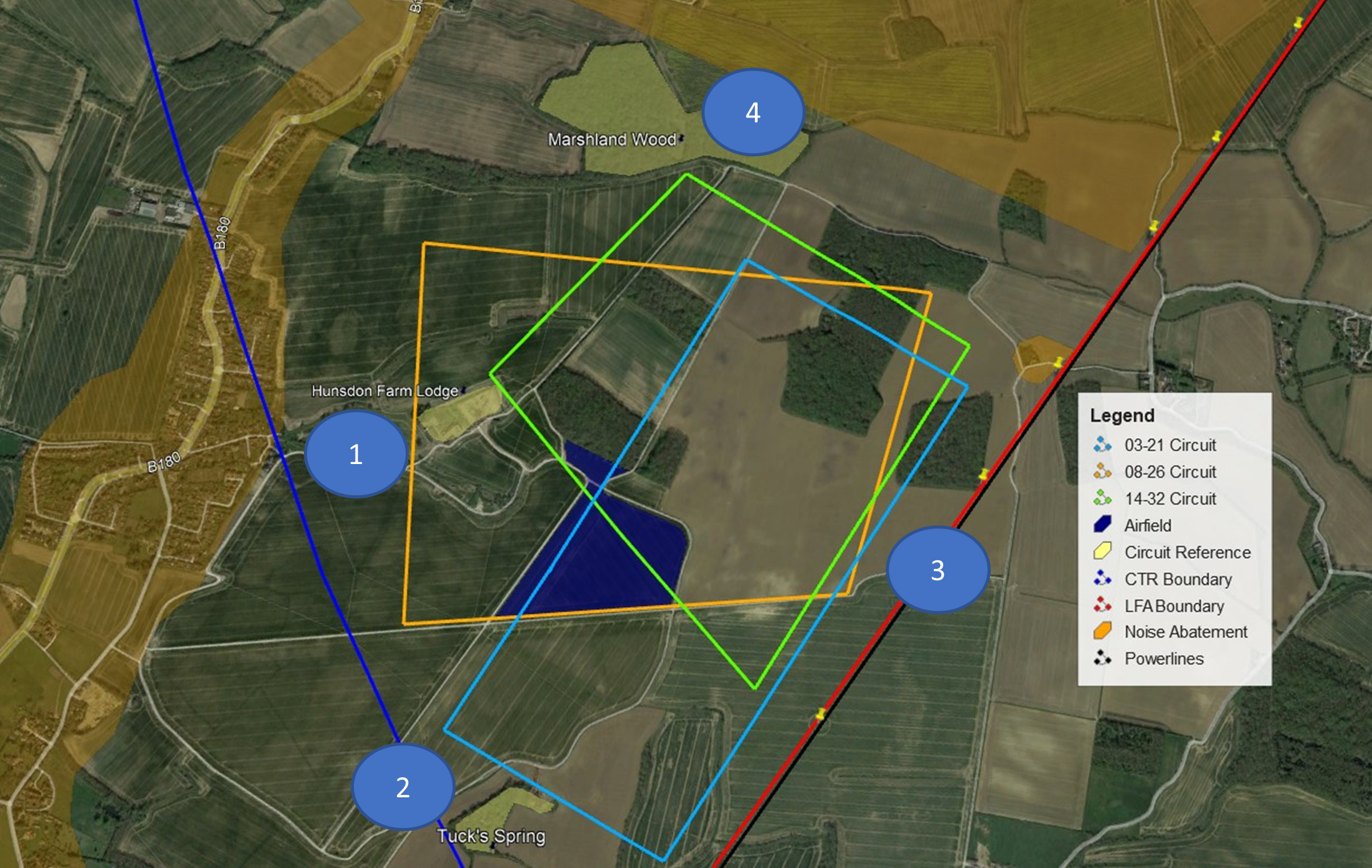
Circuit reference points
Noise abatement areas
Noise abatement areas should be considered only when it is safe to do so. It is generally always safer to fly over noise abatement areas than to, for example, turn without sufficient airspeed or to infringe controlled airspace.
Noise abatement areas are depicted on the chart below in brown and are:
- The built-up areas of Hunsdon to the west of the airfield
- The farm to the northeast of the airfield
- The farmland to the north of Marshland Wood
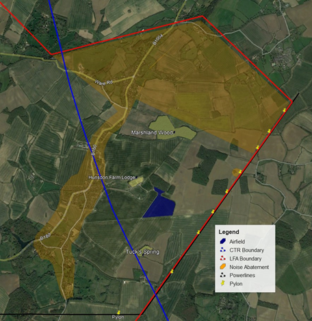
Noise abatement areas
Visual Reference Points (VRPs) and notable features
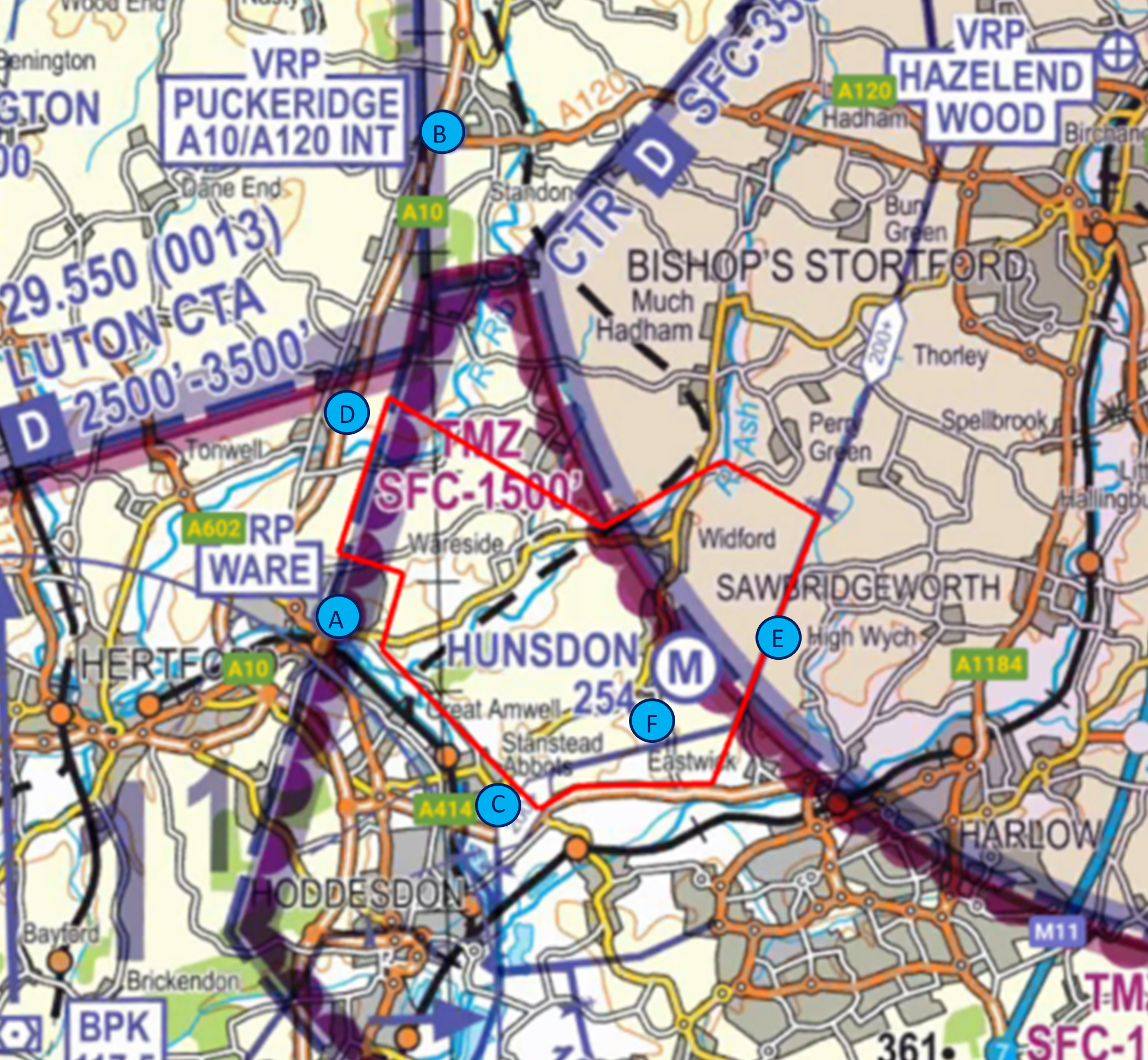
Visual Reference Points (VRPs) and Notable Features
- VRP Ware
Approximately 3.5NM west of Hunsdon, Ware is a town which sits on the western boundary of the Stansted TMZ-2. It is identifiable by a large Sport Stadium/Athletics track to the north.
Pilots operating in the AoO should remain north of Ware. - VRP Puckeridge (A10/A120 Interchange)
VRP Puckeridge is a town approximately 5NM north-northwest of Hunsdon. It lies in in Class G airspace under the Stansted CTA-4, on its border with Luton CTA-1. The base of controlled airspace here is 2,500 feet AMSL. - Stansted Abbots Marina
Southeast of Ware, Stansted Abbotts Marina is outside of the Hunsdon AOO and within the TMZ-2.
Pilots operating in the AoO must remain to the north of the bodies of water. - High Cross
A small village located approximately 4NM west-northwest of Hunsdon. It is to the west of the A10 road and lies in Class G airspace, just west of the boundary of TMZ-2.
Pilots operating on the AoO should route south of High Cross and north of VRP Ware. - Pylons/Powerlines
North/south powerlines mark the eastern AoO boundary. - Hunsdon House
A stately home north of the powerlines, visible on climb-out from Runway 21, approximately 1NM from Hunsdon. The building is square and a flag usually flies on the roof. Located inside the AoO.
Frequencies
| Unit | Frequency | SSR | Use |
| SafetyCom | 135.480 MHz | 7010 | When routing into/out of/within Hunsdon AOO |
| Farnborough LARS North | 132.800 MHz | As Allocated | 0800-2000 hours. |
| Stansted Radar | 120.625 MHz | 7013 (FMC) | H24 |
| Stansted ATIS | 127.175 MHz | N/A | H24 |
Airspace infringement prevention
It is important to be aware of avoiding airspace infringements, especially when operating in proximity to controlled airspace structure as at Hunsdon.
The following are general pieces of infringement avoidance advice to keep in mind during all flights and when you are planning your flight .
Apply Threat and Error Management (TEM) in both planning and flying
Identify threats you may face and errors that you may make. Threats could include airspace, weather, equipment failure or distraction and errors could involve navigation or incorrect instrument reading. Plan for how you would address each, so you are not surprised in-flight.
> Read more on TEM: Threat & Error Management
Plan your flight appropriately using regulated material
Study airspace structures along your route and make note of vertical as well as lateral dimensions. Be aware of using non-regulated, third-party materials as your sole source of planning – make use of regulated, up to date paper charts and NATS UK Aeronautical Information Service (AIS) to access NOTAM, the UK Aeronautical Information Publication (AIP) & Supplements and UK Aeronautical Information Circulars (AICs). In the UK, NATS AIS is the authorised source of UK aeronautical information provided on behalf of, and regulated by, the CAA
Plan your route to “TAKE2” – remain 200 feet from the base of controlled airspace and/or 2 NM from the edge. You could always increase this buffer in cases of thermic or windy conditions.
Correctly use a VFR moving map
Ensure your device’s chart is updated before you plan your route and that you carry a backup if your device was to fail in flight. Familiarise yourself with your Moving Map’s user guide. Moving Map technology should not be the sole means of planning or navigation as highlighted in the European General Aviation Safety Team’s Safety Promotion Leaflet, Using Advanced Navigation Technology Safely.
In flight, make sure that the moving map is within your field of vision, that it is showing airspace boundaries and that airspace alerts are enabled. Don’t cancel airspace alerts until you are completely aware of them and the associated TEM.
Make use of an Air Traffic Service or a Frequency Monitory Code (FMC)
Familiarise yourself with the different UK Flight Information Services available to you and the differences between a basic, traffic and deconfliction service. Make use of a Lower Airspace Radar Service (LARS) where available.
If operating proximate to controlled airspace and you do not want to obtain an air traffic service, listen to an appropriate frequency, and use the FMC rather than squawking 7000. This way, the unit will be able to contact you quickly should they need to.
In the case of Stansted, the Frequency is 120.625 MHz and the squawk is 7013 as annotated on the VFR chart.
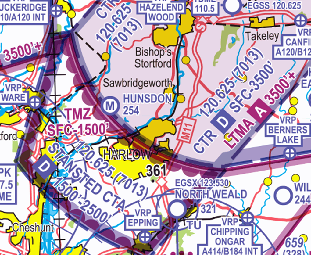
Chart extract showing Stansted frequency and squawk ID
> Download listening squawks: Listening squawks
Preventing ATZ infringements of the RAF Topcliffe Aerodrome Traffic Zone (ATZ)
This infringement update is the 36th in a series of narratives focusing on identified infringement ‘hot-spots’ in the UK.
It has been written by the Aerodrome Controlling Authority at RAF Topcliffe and members of the CAA’s Airspace Infringement Team. In 2022 there were 6 airspace infringements of the ATZ since October 2022.
Background
RAF Topcliffe is located approximately 6NM northeast of the town of Ripon, 2NM southwest of Thirsk and 3NM east of the A1(M) in North Yorkshire. It is home to 645 Volunteer Gliding Squadron (VGS) which is part of 2 Flying Training School (2 FTS).
As well as the permanent home of Yorkshire Air Ambulance (YAA), the aerodrome is an active gliding site and its staff provides military flying training to RAF Air Cadets (RAFAC) using the Viking T Mk 1 glider; it is notified for that activity in the UK AIP ENR 5.5 AERIAL SPORTING AND RECREATIONAL ACTIVITIES as follows:
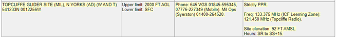
Figure 1 – Correct at AIRAC 05/2023
Topcliffe has 6 runways designated as 02/20, 08/26 and 13/31 and is notified as a winch launch glider site with both aero tow and winch launching. To facilitate the latter, cables are notified up to 2,100 feet above mean sea level – this is annotated on the chart by the blue circle within the ATZ and the G/2.1 (Figure 2). Other aspects of the notified aeronautical information as charted are subject to recent changes which will be explained further in this narrative.
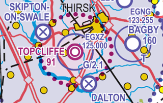
Figure 2 – site annotated by the blue circle within the ATZ
Topcliffe Aerodrome Traffic Zone (ATZ)
A Class G Aerodrome Traffic Zone (ATZ) of 2NM radius extending to 2,000 feet above aerodrome level (2,091 feet above mean sea level) exists as per Article 5 of the Air Navigation Order 2016 with Topcliffe being notified, for the purposes of Rule 11 of The Rules of the Air Regulations 2015, as a Government Aerodrome (Figures 3 and 4).
For the purposes of Rule 11(5), the ATZ operating hours are 0800 hours local to Sunset + 15 minutes (0700 hours UTC to Sunset + 15 minutes). Topcliffe provides a Military Air Ground Communication Service (MAGCS). This service is regulated by the MAA rather than CAA but in terms of service provision the only difference is that the MAGCS unit can issue instructions to its own aircraft.
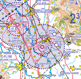
Figure 3 – ATZ
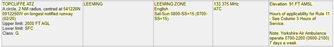
Figure 4 – Correct at AIRAC 05/23
NOTAM, UK AIP and chart amendments
A NOTAM has been issued (U2523/23) to amend the entry above in the UK AIP at En-route section 2.2 (ENR2.2); this NOTAM will expire when the AIP entry is amended:
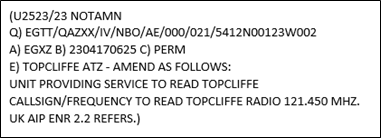
AIRAC 07 to be issued on 13 July 2023 will amend the UK AIP at En-route section 2.2 (ENR2.2) to read:

This means that during the notified hours above, the commander of the aircraft must obtain information from the air/ground communication service to enable the flight to be conducted safely within the ATZ.
In addition, when inside the ATZ, the commander of the aircraft must maintain a continuous watch on the Topcliffe Radio frequency (121.450 MHz); they must also communicate the aircraft’s position and height to Topcliffe Radio on entering the ATZ and immediately prior to leaving it. In addition, 4 chart amendments have been notified as follows:
![]()
- 1:500,000 VFR Chart. Amendments for Northern England & Northern Ireland Edition 46 effective 20 April 2023.
- 1:250,000 VFR Chart. Amendments for Sheet 4 – The Borders Edition 13 effective 14 July 2022. –
- 1:250,000 VFR Chart. Amendments for Sheet 5 – Central England and Wales Edition 14 effective 12 August 2021.
- 1:250,000 VFR Chart. Amendments for Sheet 6 – England East Edition 15 effective 15 July 2021
Risks of overflying winch launch sites
Pilots should not plan to transit directly overhead the aerodrome, even above the ATZ, as winch launching activity extends to 2,100 feet above mean sea level and there is a risk of a cable strike (Figure 5).
A 4.5 mm Dyneema or steel wire in the air, when struck by an aircraft could have fatal consequences for both the aircraft impacting the wire and the glider, if still attached to the cable. Pilots should be aware that the vertical extent relates only to the maximum altitude of the cable and not to the maximum altitude to which gliders may be encountered operating in the airspace above the ATZ.
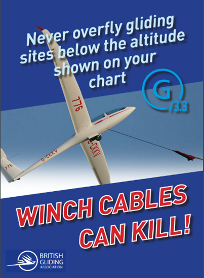
Figure 5 – BGA cable warning
Preventing an airspace infringement
The Airspace & Safety Initiative website provides extensive advice on how to avoid the risk of infringing airspace. Pilots are strongly encouraged to:
Use a VFR Moving Map. In recent causal factor analysis, the correct use of VFR Moving Map technology could have prevented 85% of analysed airspace infringements from occurring. Based on these statistics the CAA actively encourages pilots to use VFR Moving Maps as part of their planning and when in flight, because they can enhance a pilot’s positional situational awareness and can also offer timely alerts to airspace and aviation hazards. However, Moving Map technology should not be the sole means of planning or navigation as highlighted in the European General Aviation Safety Team, Safety Promotion Leaflet, Using Advanced Navigation Technology Safely (EGAST GA7 page 3 refers).
It is also important to remember that Moving Map APPs are not regulated by the CAA and users should note that the depiction of aeronautical information on VFR Moving Maps may be different to that on the UK Aeronautical Information products accessed via the NATS AIS website, such as VFR charts, the UK AIP and NOTAM information (NATS AIS is the authorised source of UK aeronautical information provided on behalf of, and regulated by, the CAA).
When using VFR Moving Maps, although the gliding symbol is reasonably clear, the difference in presentation from the CAA chart is significant.
Pilots are to be aware that on some VFR Moving Maps:
- There may be no indication of winch launching;
- There may be no information of the maximum height of winch launches. To obtain that information the user needs to open the information tile by pressing on the glider site symbol and read the information contained in the ‘Airspace’ section.
Understand and apply Rule 11 – To fly in the Topcliffe ATZ, pilots must obtain information from the AGCS (callsign TOPCLIFFE RADIO on frequency 121.450 MHz) to enable the flight to be conducted safely within the ATZ. If you are unable to establish 2-way communications or if told to “Standby” you should not enter the ATZ.
Plan ahead and have a contingency plan (Plan B) – Especially during busy periods, the frequency may be busy and so sufficient time should be allowed in order to establish two-way communication and aerodrome information. Have a backup plan should you be unable to establish contact. This may involve re-routing or holding within the local area, being careful of other airspace in the vicinity.
Reference material
Infringements of Aerodrome Traffic Zones (ATZ)
Airspace and Safety Initiative hot-spot narrative (14) https://airspacesafety.com/hot-spot-narratives/
Flying over gliding sites
- CAA safety guidance: caa.co.uk/glidingsites
- CAA short safety animation:https://youtu.be/4HIUSJba-pM
- British Gliding Association (BGA): Overflight of winch launch site guidance
- BGA winch cable warning e-posterto download and display
Threat and Error Management – read Threat & Error Management
Plan your flight – read Pre-flight planning
Using Advanced Navigation Technology Safely
European General Aviation Safety Team, Safety Promotion Leaflet (EGAST) GA7 – read EGAST GA7
Restricted Area (Temporary) – RA(T)
This infringement update is the 37th in a series of narratives focusing on identifying infringement hot-spots in the UK.
A Restricted Area (Temporary) also known as a RA(T), is a temporary airspace structure established under article 239 of the Air Navigation Order (ANO) 2016 to ensure the safety of participants or attendees during specific events/activities or for reasons of National Defence or any other reason affecting the public interest.
A RA(T) will always be designed to restrict aircraft using the minimum amount of airspace to achieve this aim. Whilst most are areas of specified radius, some RA(T)s can be more complex in shape.
Some examples of events/activities where a RA(T) may be established include:
- Airshows
- Air Racing
- Flypasts
- Festivals
- Specific Helicopter Flights
As a RA(T) is specific to individual locations and event, an airshow with slower participants displaying at lower altitudes will have a smaller RA(T) than one which has, for example, a fast jet display carrying out high energy manoeuvres. This affords the aircraft engaged in display manoeuvres protection from unknown traffic but does not restrict transit traffic through the area disproportionately. Due to manoeuvres associated with displaying a large formation team (such as the Red Arrows), shorter, individual displays, although part of the bigger event, require a larger volume of restricted airspace.
In 2022, 115 RA(T)s were established under article 239 of the ANO 2016.
A RA(T) can be promulgated in three combinations:
- NOTAM and Aeronautical Information Circular (AIC),
- NOTAM and Briefing Sheet, or
- NOTAM.
All RA(T)’s will be included in the NATS AIS Information line recording.
In each case, a J-series NOTAM will be published detailing the date, time, and dimensions of the RA(T). The NOTAM will reference the relevant AIC or briefing sheet, providing more information and when applicable, a chart depicting the RA(T) to help pilots visualise the restrictions in place. It is therefore important to ensure a thorough NOTAM brief is carried out prior to every flight and that you take into consideration any J-series NOTAMs that may affect your route; this brief should also refer to addition documents references in the NOTAM. Valid NOTAMs can be viewed on the NATS AIS website.
Figure 1 relates to the Royal International Air Tattoo (RIAT) 2022:
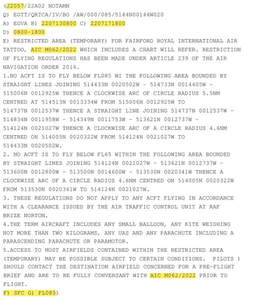
Figure 1 NOTAM J2057_22
Figure 1 notifies you of the RIAT RA(T) in place from 13 July 2022 to 17 July 2022 during the hours of 0800 and 1800 UTC daily, comprising of 2 areas (one from Surface to FL65 and one from Surface to FL85). The NOTAM references AIC M062/2022 which has a graphical representation of the area in the most current aeronautical chart. For further guidance on decoding NOTAMs, please refer to the Online Tutorial: Notices to Aviation.
NOTAM and Aeronautical Information Circular (AIC)
If time permits, an AIC is published in addition to a NOTAM to add explanation or emphasis on matters of safety or operational significance. UK Airspace Restrictions imposed in accordance with the Temporary Restrictions of Flying Regulations will be notified through the issue of a Mauve AIC.
All AICs can be found on the NATS AIS Website under the ‘Publications’ tab (see Figure 2) and selecting ‘Aeronautical Information Circulars (AICs)’. From there, you can view all the AIC categories (see Figure 3).
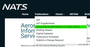
Figure 2: NATS AIS AIC tab
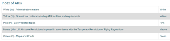
Figure 3 Index of AICs from NATS AIS Website
Each AIC issued has its own identification. An AIC relating to a RA(T) will be identified by the letter ‘M‘ to signify the AIC is within the Mauve category, followed by three numbers and the year the AIC is effective. This identification will be referenced in the corresponding NOTAM to assist in your briefing.
The AIC contains details relating to the time and date that the RA(T) is active as well as the dimensions, restrictions to aircraft, who to request permission from in order to enter the RA(T) and a visual depiction on a chart (see Figure 5) to provide a clearer notification of the activity.
All AICs follow a 28 working days publishing schedule and a minimum of 90 days’ notice is required for temporary airspace restrictions requests made to CAA Airspace Regulation (AR).
Figures 4 and 5 below relate to the RA(T) established for the Royal International Air Tattoo (RIAT) 2022 and are extracts from AIC M062/2022.
Figure 4: AIC M062/2022
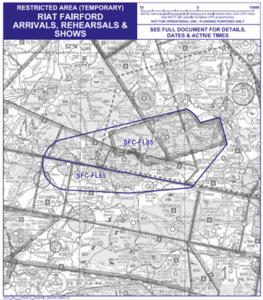
Figure 5: AIC M062/2022 Chart extract
NOTAM and Briefing Sheet
For complex structures where the AIC 28 working days publishing schedule cannot be met, the CAA AR team will aim to issue a Briefing Sheet. Similar to an AIC, the Briefing Sheet will contain details relating to the time and date the RA(T) is active, the dimensions, the restrictions to aircraft, who to request permission from in order to enter the RA(T) and where applicable a visual depiction of the RA(T) on a chart.
All briefing sheets can be found on the NATS AIS Website under the ‘Publications’ tab and selecting ‘Briefing Sheets’ (See Figure 6). From there you can download the relevant information. Whenever time permits, the NOTAM and Briefing Sheet are also announced via the CAA’s Skywise notification platform.
Figure 6: NATS AIS Briefing Sheets tab
Specific helicopter flights require a RA(T) to allow the flight to be conducted in a safe operating environment and to allow the passengers of the flight to reach their destination in the safest way possible. Due to the short notification period of these helicopter flights, a briefing sheet is published for every flight.
Figures 7 and 8 relate to a RA(T) established for a specific helicopter flight.
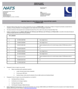
Figure 7: Briefing Sheet extract
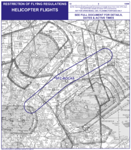
Figure 8: Briefing Sheet chart extract
Emergency Restriction of Flying Regulations
In the event of a disaster or major incident occurring on land or sea, within the boundaries of the Scottish or London Flight Information Regions, an Emergency Controlling Authority (ECA) may request that an Emergency Restriction of Flying (ERF) be made under the ANO 2016. This is done to prohibit flight in the vicinity of the incident by aircraft not directly engaged in emergency action and thus ensures the safety of life and property, particularly for those working at the scene of the incident or engaged in Search and Rescue (SAR) operations. Similar restrictions may also be necessary in the case of an emergency not classed as a disaster or major incident. In 2022, 9 ERF were established around the UK.
When ERF have been brought into force, the notified ECA is the only authority which may grant permission for aircraft to be flown within the notified airspace. Subject to overriding considerations of safety, flights by aircraft directly associated with the emergency action will be given priority over those seeking to overfly the area for any other reason.
Due to the nature of these restrictions, the means of notification are much more limited; a J series NOTAM (Figure 9) will be immediately issued but this serves only to notify pilots in the pre-flight planning phase and Air Navigation Service Providers.
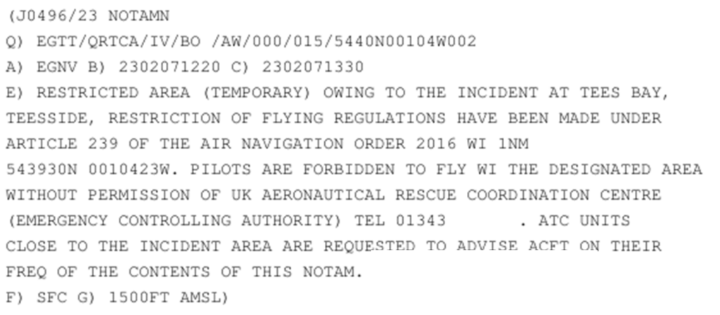
Figure 9: J Series NOTAM
To cascade this information, the Distress and Diversion (D&D) cell at Swanwick Centre will broadcast a sécurité message on the aircraft emergency frequencies (GUARD) of 121.500MHz and 243.000MHz; air traffic service units close to the area will also advise pilots of aircraft on frequency.
The restriction to airspace will also be promulgated through the NATS AIS Information Line. The information on this telephone line will not be sufficient to use solely as briefing material but will be useful in supplementing your planning as it will not only provide you with information on planned RA(T) but also on any ERF that may have been established since your last briefing. Two numbers are available as follows:
- 08085-354802; or
- +44(0)1489-887515.
How to Avoid the Risk of Infringing a RA(T)
Pre-flight planning
It is important to plan every flight in detail. Always carry out a NOTAM brief prior to every flight no matter how short or local your flight is anticipated to be. When carrying out your NOTAM brief, ensure you study the J-Series NOTAMs and also read the relevant Briefing Sheet or AIC that relates to the RA(T), to assist in your briefing and provide you with as much information as possible. The NATS AIS Telephone Information Line should always be called prior to every flight or individual sector if you are carrying out intermediate landings for, rest, fuel, refreshments etc. Although the telephone line is not sufficient to use solely as briefing material, it will inform you of any RA(T) established since your briefing including any ERF.
Always use a VFR Moving Map
It is recommended to use a VFR Moving Map as part of both your pre-flight route planning and in-flight to display the most ‘up to date’ airspace situation. Ensure your device is connected to the internet when planning your flight.
As all RA(T) will be notified by NOTAM, they should appear on VFR Moving Map displays provided that the platform is connected to the internet at the time of planning and provided the NOTAM has been issued at that time.
Apply Threat and Error Management (TEM)
It is essential that you apply effective TEM in your planning and flying. Identify the Threats that will affect your flight and have a ‘Plan B’ in case you need to divert or route around airspace.
It is recommended that you apply the ‘Take 2’ guidance when flying proximate to restricted airspace. In any case, when flying in the vicinity of such notified airspace structures, it is essential that a good lookout is maintained for other traffic which may be routing around the area. In addition, for air display RA(T), beware of participants, including fast-jets and large aircraft or formations holding outside the RA(T) awaiting a display slot-time and clearance to ‘run-in’.
Use the most appropriate Air Traffic Service (ATS)
During pre-flight planning stages, it is important to plan your Radio Telephony (R/T) for your route. Should you require permission to enter the RA(T), obtain the relevant details from the AIC or Briefing Sheet and ensure you call on frequency with enough time to obtain a clearance/permission. If you are routing around the RA(T), pilots are encouraged to obtain a service from ATC or use a Frequency Monitoring Code (FMC) to either prevent infringements or enable their prompt resolution.
If a pilot is using the most appropriate ATS, should an ERF be established mid-flight, the relevant ATS will inform the pilot of the restrictions.
Infringement statistics analysis has identified a trend in infringements of Stansted airspace. This hot-spot narrative is the second in a series covering satellite airfields around Stansted controlled airspace. It is intended to provide guidance to help pilots operating at North Weald prevent airspace infringements.
DOWNLOAD North Weald Area of Operation A5
North Weald Aerodrome (EGSX) is located at 51°43’18″N, 0°9’15″E, approximately 10NM from Stansted Airport on a bearing of 197°. The aerodrome lies within the Stansted Transponder Mandatory Zone (TMZ-2) which extends from the surface to 1,500 feet AMSL and beneath Stansted Control Area (CTA-2). An Area of Operation (AoO) is established to facilitate flight at North Weald for aircraft unable to comply with TMZ requirements.
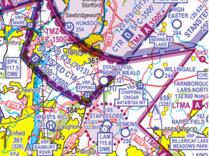
Figure 1: Chart extract from CAA 1:500k Sheet 2171CD Southern England and Wales Edition 49 (2023)
Controlled Airspace Proximate to North Weald
Figure 2: Chart extract from AD-2-EGSS-4-1 and table showing airspace structures
| Structure | Airspace Class | Level (AMSL) | |
| 1 | Stansted CTR | D | Surface – 3,500 feet |
| 2 | Stansted CTA-1 | D | 1,500 feet – 3,500 feet |
| 3 | Stansted CTA-2 | D | 1,500 feet – 2,500 feet |
| 4 | Stansted CTA-3 | D | 2,500 feet – 3,500 feet |
| 5 | Stansted CTA-4 | D | 2,500 feet – 3,500 feet |
| 6 | Stansted TMZ-1 | G | Surface – 1,500 feet |
| 7 | Stansted TMZ-2 | G | Surface – 1,500 feet |
| 8 | Stapleford ATZ | G | Surface – 2,185 feet |
| 9 | LTMA-1 | A | 2,500 feet – FL195 |
| 10 | LTMA-3 | A | 3,500 feet -FL195 |
Area of Operation (AoO)
North Weald lies within Stansted TMZ-2, within which aircraft must carry and operate a serviceable Mode-S transponder (as per SERA.60005 (b)). An AoO is established up to 1500 feet AMSL to facilitate flight into and out of North Weald for aircraft unable to comply with the requirements of the TMZ.
The AoO is depicted below (Figure 3) and its shape comprises a circle of 2NM radius centred on 51°43’18″N, 0°9’15″E, with a “stub” to the southwest which extends approximately 1.5NM west of the eastern TMZ boundary. Epping Visual Reference Point (VRP) is within this stub.
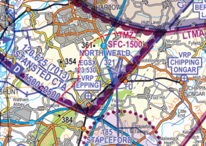
Figure 3: Chart extract from CAA 1:250k Sheet 8 England South Edition 26 (2022) showing EGSX AoO
Aircraft without a serviceable Mode-S transponder must adhere to one of the following two options when visiting North Weald:
- Route entirely via the North Weald AoO; or
- Obtain a permission from either:
- Farnborough Radar on 132.800 MHz between 0800 hours and 2000 hours UTC; or
- Stansted Radar on 120.625 MHz at other times.
Aircraft without serviceable Mode-S wishing to operate within the TMZ, outside of the AoO, must gain specific Air Traffic Control (ATC) approval.
North Weald Procedures
Circuit Procedures
There are two reciprocal runways at North Weald, Tarmac/Concrete and Grass both orientated 02/20. Circuits are conducted to the west at 1,200 feet QNH. Due to the Stansted CTA above, overhead joins are not permitted.
Visual cues for the circuit can be seen below (Figure 5). To avoid an infringement of the Stansted CTR, pilots should make turns abeam or south of the M11 Junction 7 Roundabout. Aircraft unable to comply with TMZ requirements MUST turn at M11 Junction 7 to remain inside the AoO, see below (Figure 4).
All aircraft MUST remain south of The Church Langley Water Tower which lies on the boundary of the CTR (see Figure 5).
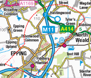
Figure 4: M11 Junction 7
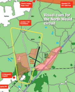
Figure 5: EGSX circuit cues
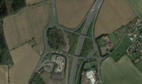
M11 Junction 7 Roundabout from above.
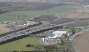
M11 Junction 7 Roundabout from 1200 feet
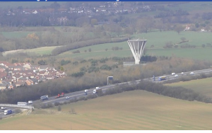
Church Langley Water Tower
Airspace Infringements at North Weald
Due to the nature of North Weald’s location in relation to Stansted Airport, the impact of infringements in this area on Stansted Airport’s operations is high and often requires the implementation of safety intervention measures from ATC. These measures can include the issuing of traffic information, radar vectors or avoiding action or in the suspension/delay in departures. ATC must ensure that a minimum of 3NM or 3,000 feet is maintained between aircraft inbound to Stansted and any infringing aircraft. Should less separation be achieved a loss of separation occurs and the controller is suspended from controlling duties pending investigation.
Below (Figure 6) is a snapshot from the CAA’s Airspace Analyser Tool. Figure 6 illustrates aircraft tracks inbound to Stansted which were routed from the South over North Weald within CTA-2 at between 1,500 and 2,500 feet (AMSL) from 1 January 2023 to 22 June 2023. The lowest aircraft was recorded at 1,700 feet. The 3NM scale line highlights the radius that must be maintained around an infringing aircraft, as 3,000 feet separation would not be possible.
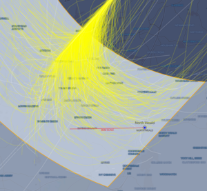
Figure 6: EGSS inbound tracks from the south at 1,500 feet – 2,500 feet, 1 January 2023 – 22 June 2023.
Types of infringement reported in the vicinity of North Weald
Vertically into CTA-2
Due to the airfield elevation of 321 feet, it is essential that you operate on the Stansted QNH to avoid entering the CTA above. You must ensure that climbs are arrested at the circuit altitude of 1,200 feet and you maintain a high level of monitoring of your altitude after departing the circuit, beneath the CTA.
Tips to avoid a vertical infringement of Stansted CTA-2
- Minimise distraction within the cockpit whilst climbing out, flying in the circuit and beneath the CTA to enable you the capacity to monitor your altitude. The concept of a ‘sterile cockpit’ is not limited to commercial aircraft operations.
- Remind yourself of the 1,200 feet circuit limit on your pre-departure checklist.
- Understand the impact of forecast weather on your flight. Thermic or turbulent conditions can inadvertently push you updwards. A strong headwind will result in a greater climb angle, as with reduced ground speed you will travel a shorter distance laterally before reaching 1,200 feet, which is important to consider if you use ground features as circuit turning points without referencing your altitude. Use the regulated Met Office Aviation Briefing Service in your planning.
- Only depart when you are comfortable and ready. Do not rush yourself into a gap in the circuit traffic to the detriment of your situational awareness. It has been found that rushing to depart in such a gap has often led to pilots forgetting to select their transponders on to ALT. Thereby leading to an infringement of the TMZ.
- Monitor your altitude after leaving the North Weald circuit – you are still flying under the CTA, when possible Take 2 – remain 200 feet below the base.
Laterally into the CTR
The Stansted CTR is less than 2NM on runway heading from the airfield boundary to the north northeast It is of particular importance when managing the workload of climbing out from Runway 02, however must also be considered when managing traffic ahead when downwind for Runway 20.
Tips to avoid a lateral infringement of the Stansted CTR
- Be aware of your ground speed – particularly if operating an aircraft with a higher relative performance than one you are used to, you’ll approach the CTR quicker.
- If safe to do so, turn abeam the M11 Junction 7 roundabout. This will give you a 1NM buffer from the CTR.
- If unable to turn at M11 Junction 7, you MUST ensure you turn prior to the Church Langley Water Tower. Your turn should be commenced prior to the built-up area of Church Langley west of the M11 to ensure it is completed before the water tower.
- Do not be pressured by limited gaps in the circuit. Departing too soon after a preceding aircraft (particularly one slower than you) will result in the need to extend your climb from 02 out for separation. When operating on Runway 20, consider slowing your cruise, going around at circuit height or leaving the circuit to avoid extending the downwind leg into the CTR.
Lateral into CTA-2
Overhead joins are not permitted at North Weald. You must plan how you will integrate with established circuit traffic ahead of time.
Tips to avoid a lateral infringement of Stansted CTA-2
- Do not plan to overfly North Weald if transiting TMZ-2, without having established two-way communications with North Weald Radio on 123.530 MHz. The circuit is often busy at 1,200 feet, leaving very little distance from the CTA above should you need to climb to avoid traffic. Overflying North Weald without establishing positions of circuit traffic increases the risk of a mid-air collision. Alternatively, request a clearance from Stansted Radar to transit the CTA above North Weald or obtain information from Stapleford Radio on 122.805 MHz to transit the Stapleford ATZ in accordance with Rule 11 (5) of the Rules of the Air Regulations 2015.
- Incorporate an easily identifiable limit point into your pre-flight planning, which is plotted on your chart and PLOG beyond which you won’t proceed until at circuit height to avoid last moment descents below the CTA or the effect of a strong tailwind. From the east such a limit point could be Chipping Ongar A414/B184 Interchange VRP or from the southwest M25 Junction 26.
- Increase your situational awareness by listening out on the North Weald Radio frequency (123.530 MHz) to establish a picture of the traffic situation at the airfield prior to arrival. Identify an area in your planning in which you can hold if the airfield traffic is high and wait until you have a full picture before commencing your join. Remember North Weald Radio is non-surveillance so should only be used when arriving, departing, or operating in the circuit.
TMZ-2
Aircraft operating at North Weald must either be Mode-S equipped, operate wholly within the AoO or obtain a permission from Farnborough or Stansted Radars (as detailed above.)
Tips to avoid an infringement of Stansted TMZ-2
- Check, check and check again. Include an ALT check on your checklist immediately prior to departure. Incorporate it into your checks once lined up, and once again when airborne, prior to leaving the AoO. Confirmation bias is a common causal factor in TMZ infringements.
- Incorporate an ALT check into your limit point identified at the pre-flight planning stage when inbound to the airfield. Do not proceed beyond until you have descended to circuit height AND checked your transponder is set to ALT.
- Check your transponder is within limits. Farnborough LARS can advise if your Mode-C is displaying erroneously against your altimeter. The maximum error of altitude encoder and transponder equipment can be no more than +/- 125 feet.
- Request a permission to transit the TMZ if your transponder is in-operational or out of limits (as detailed above), or if you are uncertain of its operational status in-flight.
How to avoid airspace infringements
Apply Threat and Error Management
Identify threats you may face and errors that you may make. Plan for how you would address each, so you are not surprised in-flight.
Threats at North Weald include:
- Notified airspace: Stansted CTA-2, Stansted TMZ-2, Stansted CTR or Stapleford ATZ
- Other aircraft: the area in the vicinity of North Weald and Stapleford can become very congested with traffic of varying performance levels.
- Distraction, for example from passengers or technical issues. Workload is high in the vicinity of North Weald and you must be wholly focused on the flying task. See Safety Sense Leaflet 31 on Distraction and Interruption
Errors you could make at North Weald include:
- Operating within the TMZ, outside of the AoO, without an operational Mode-S transponder displaying ALT information.
- Extending your climb-out (from Runway 02) or downwind (Runway 20) leg, leading to an inadvertent entry into the CTR.
- Losing situational awareness as to your lateral and vertical position relative to CTA-2.
- Fail to formulate a contingency plan (a ‘Plan-B’ ) in your pre-flight planning. The airspace in this area can be very busy, including limit points in your plan can create more time in the air to manage the workload.
> Read more on TEM: Threat & Error Management
Plan your flight appropriately using regulated material
Study airspace structures along your route and make note of vertical as well as lateral dimensions. Be aware of using non-regulated, third-party materials as your sole source of planning – make use of regulated, up to date paper charts and NATS UK Aeronautical Information Service (AIS) to access NOTAM, the UK Aeronautical Information Publication (AIP) & Supplements and UK Aeronautical Information Circulars (AICs). In the UK, NATS AIS is the authorised source of UK aeronautical information provided on behalf of, and regulated by, the CAA.
Where able, plan your route to “TAKE2” – remain 200 feet from the base of controlled airspace and/or 2 NM from the edge. You could always increase this buffer in cases of thermic or windy conditions.
Obtain an appropriate Air Traffic Service or use a Frequency Monitoring Code (FMC)
Familiarise yourself with the different UK Flight Information Services available to you and the differences between a basic, traffic and deconfliction service. Make use of a Lower Airspace Radar Service (LARS) where available.
If operating proximate to controlled airspace and you do not want to obtain an air traffic service, listen to an appropriate frequency and use the FMC rather than squawking 7000. This way, the unit will be able to contact you quickly should they need to.
Whilst operating proximate to Stansted, make use of the Stansted FMC. The Frequency is 120.625 MHz and the squawk is 7013 as annotated on the VFR chart (see Figure 7). Alternatively, within the TMZ obtain a service from Farnborough LARS North on 132.800 MHz.
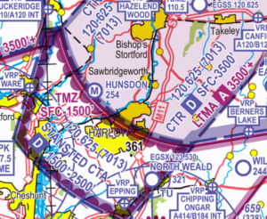
Figure 7: Chart extract showing Stansted CTR, CTA-2 and TMZ-2 with FMC annotation.
Correctly use a VFR Moving Map
Ensure your device is connected to wifi and the charting is updated before you plan your route and that you carry a backup if your device was to fail in flight. Familiarise yourself with your Moving Map’s user guide. Moving Map technology should not be the sole means of planning or navigation as highlighted in the European General Aviation Safety Team’s Safety Promotion Leaflet, Using Advanced Navigation Technology Safely.
In flight, make sure that the moving map is within your field of vision, that it is showing airspace boundaries and that airspace alerts are enabled. Don’t cancel airspace alerts until you are completely aware of them and the associated TEM.
Further information on Stansted Controlled Airspace can be found in Hot-Spot Narratives:
- 16. Stansted CTA, CTR and TMZ
- 35. Hunsdon Microlight Site
Preventing infringements of Farnborough CTA-1
Farnborough CTA-1 has been identified as an infringement hot-spot. This narrative has been written by the team at Fairoaks Airfield and at the Farnborough Air Traffic Service Unit. Its aim is to not only help pilots understand the airspace, but also the safety impact of infringements and the additional impact on LARS service provision.
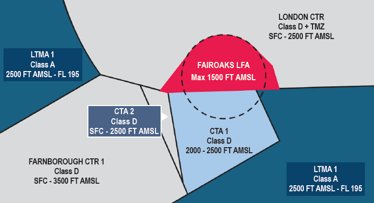
Figure 1
The Farnborough CTA-1 extends from 2,000 feet to 2,500 feet AMSL (Figure 1)
Pilots should take particular note of Control Zone 2 (CTR-2) that is adjacent to CTA-1 and extends from the surface up to 2,500ft AMSL. This small fillet of Class D airspace has a lower upper limit than the CTR-1 due to the lower base on the Class A London Terminal Control Area (TMA) above it.
IFR and VFR entry is subject to a clearance from Farnborough ATC. Requests for transit/entry clearance should be made on the Farnborough Radar channel 133.440.
You must not enter controlled airspace unless a clearance has been received.
If your intention is to remain outside controlled airspace whilst operating proximate to controlled airspace, it is good practice to consider obtaining an air traffic service from Farnborough Radar on 125.250 MHz or select the Frequency Monitoring Code (FMC) of 4572 and maintain a listening watch on 125.250 MHz.
Visual Reference Points (VRPs) in the vicinity of CTA-1
Pilots operating in the vicinity of CTA-1 should familiarise themselves with the following VRPs (Figures 2,3 and 4).
Pilots may be instructed to hold at one of the VRPs as part of a Class D transit clearance.
Pilots transiting the Class G airspace below CTA-1 should be aware of the Fairoaks Aerodrome Traffic Zone (ATZ) and other traffic operating in and out of Fairoaks aerodrome.
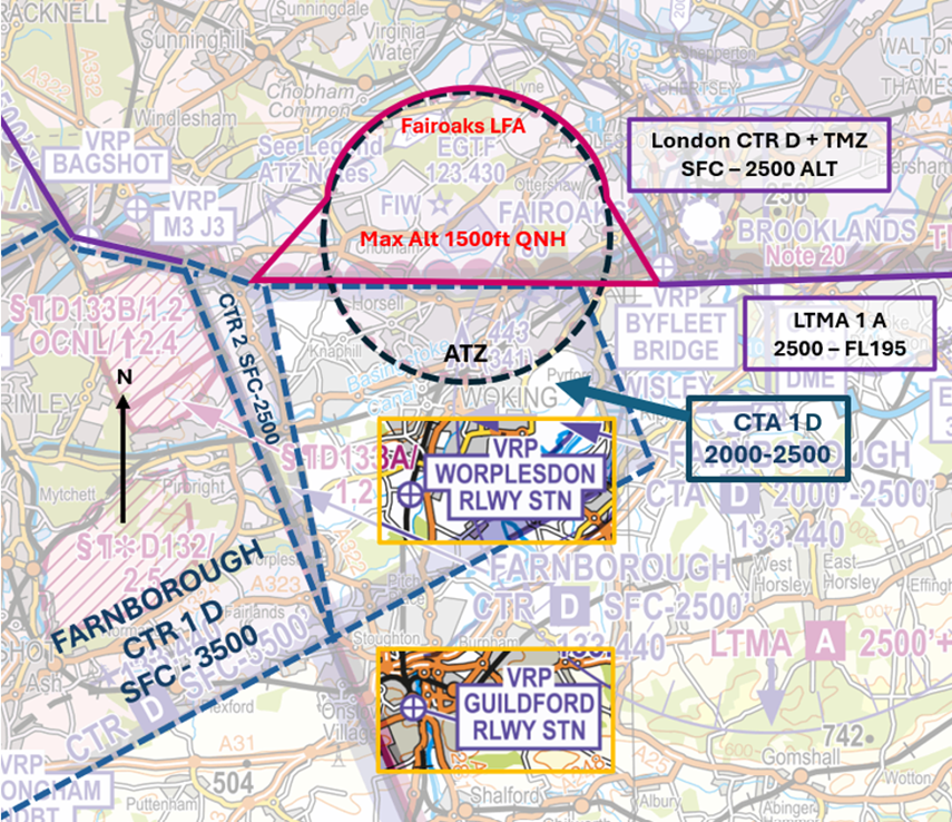
Figure 2 – CAA/NATS 1:250,000 England South – Ed.29
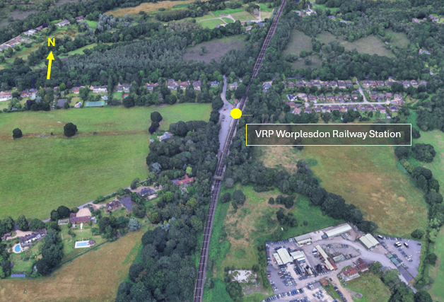
Figure 3 – Worplesdon Railway Station) VRP
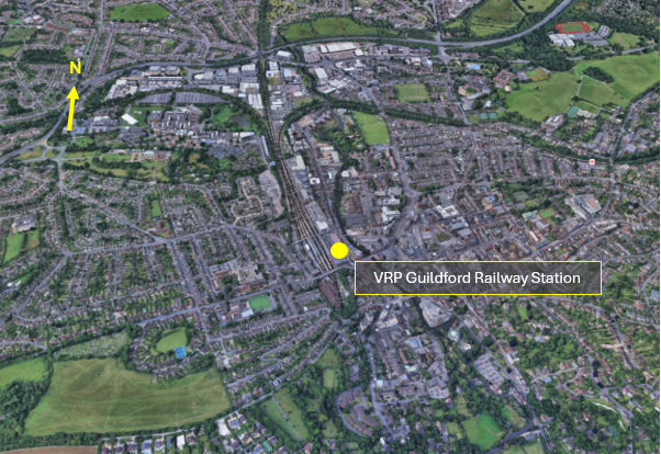
Figure 4 –Guildford Railway Station) VRP
Controlled Airspace Transits
To better understand why a transit might be denied, under what circumstances they are given, and, any conditions that might be attached to such a clearance, refer to the next section on Farnborough Operations.
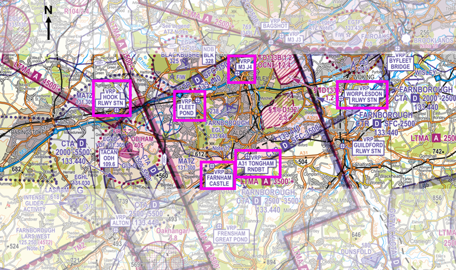
Figure 5 – CAA/NATS 1:250,000 England South – Ed.29
East/West (British Rail) (Hook/Woking)
Pilots wishing to route east/west or vice versa through Farnborough’s controlled airspace can typically expect a routing following the railway line between Hook Railway Station VRP (Figure 6) and Worplesdon Railway Station VRP (Figure 3) (commonly called ‘British Rail east/west’). If this route is unavailable due to IFR traffic, an alternative routing may be offered via the A31 Tongham Roundabout VRP (Figure 7) and Farnham Castle VRP (Figure 8).
Note: Pilots routing west to east on the railway line routing may be given a clearance limit of the Fleet Pond VRP (Figure 9) due to IFR traffic inbound runway 24. When approaching the Fleet Pond VRP onward clearance via the M3J4 VRP (Figure 10) may be issued instead to deconflict against IFR traffic on final approach.
North/South
Pilots wishing to route north/south or vice versa through Farnborough’s controlled airspace can typically expect a routing via the M3J4 VRP and the A31 Tongham Roundabout VRP or the Fleet Pond VRP and the Farnham Castle VRP. The routing offered will normally depend on runway in use and traffic operations.
Note: Pilots may be given a clearance limit to a VRP to enable safe integration with IFR traffic. The controller will provide traffic information on relevant IFR traffic to enable the pilot of the transit aircraft to become visual with the traffic and allow for an onward clearance to be issued with the traffic in sight.
Northwest/Southeast
Pilots wishing to route Northwest/Southeast or vice versa through Farnborough’s controlled airspace can typically expect a routing southwest of the Bagshot Mast (Figure 11) to the Worplesdon Railway Station VRP (remaining southwest of the Bagshot Mast will ensure you remain outside the London CTR). Pilots should be aware of the Fairoaks ATZ and other traffic operating into and out of Fairoaks.
A thorough knowledge of the VRPs associated with Farnborough CAS will better equip you for any changes to your planned routing and reduce the likelihood of an infringement.
Visual Reference Points (VRPs)
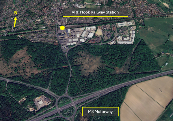
Figure 6 – Hook Railway Station) VRP
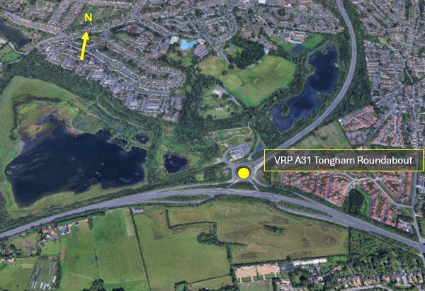
Figure 7 – A31 Tongham Roundabout) VRP
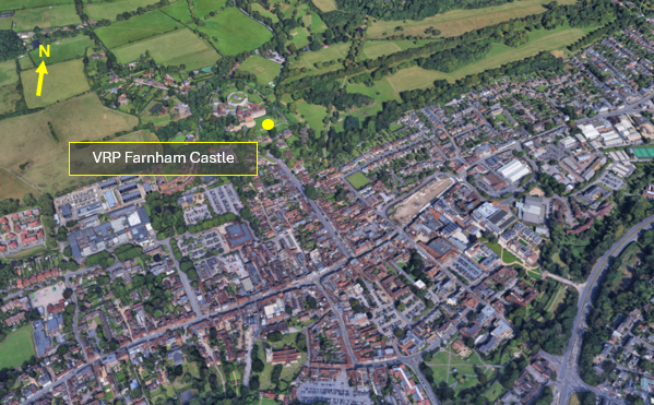
Figure 8 – Farnham Castle VRP
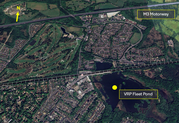
Figure 9 – Fleet Pond VRP
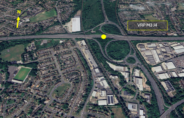
Figure 10 – M3 J4 VRP
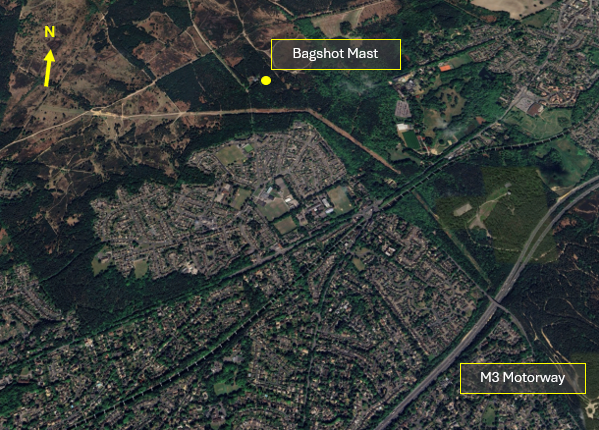
Figure 11 – Bagshot Mast
Farnborough Operations
CTA-1 infringement Hot-Spot
The Farnborough CTA-1 is a small portion of airspace (of only 500 feet) that sits below the base of the London TMA. Farnborough standard arrival (STAR) and standard instrument departure (SID) profiles are specifically designed to ensure safe integration with Heathrow Airport and Gatwick Airport departures.
Farnborough Runway 24
IFR traffic on approach to Runway 24 routes through CTA-1 on a base leg heading, descending to 2,500 feet AMSL. IFR inbound aircraft are required to be 3,000 feet AMSL or below to ensure separation against Heathrow Airport Runway 27 departures.
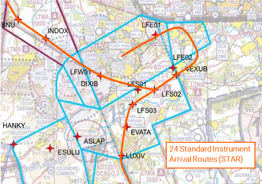
Figure 12 – Runway 24 Standard Instrument Arrival Routes – STAR
If an infringement of CTA-1 occurs when Farnborough is operating on Runway 24, ATC and aircraft can be impacted as follows:
- Loss of prescribed separation between aircraft, resulting in removal of the controller from operations.
- Resolution advice – such as avoiding action – to maintain separation.
- Delay to airborne aircraft – due to extended vectoring to avoid an infringing aircraft.
- Increased workload for all
Farnborough Runway 06
IFR traffic departing Runway 06 routes through CTA-1 on climb out following the SID profile, climbing to 3,000 feet AMSL. Aircraft are required to depart on the runway heading before commencing turn for noise abatement and to avoid EG D132 Ash Ranges.
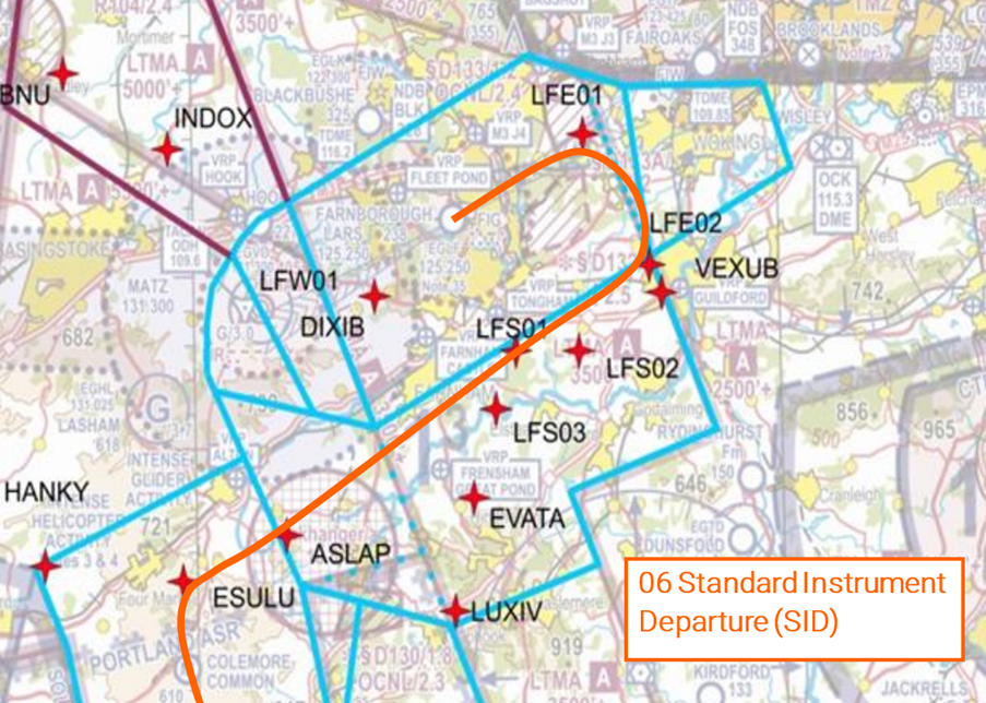
Figure 13 – Runway 06 Standard Instrument Departure – SID)
If an infringement of CTA-1 occurs on easterly operations, the impacts as above can be further complicated by the requirement to avoid EG D132 and departing aircraft operating at lower levels; aircraft on the ground may also be delayed if departure clearances are cancelled.
Example of how an infringement of CTA-1 can affect Farnborough operations whilst Runway 06 is in use:
- After departing Fairoaks Runway 24, a GA aircraft routing on a southerly track, entered Farnborough CTA-1 without a clearance, climbing to 2,100 feet where the base of controlled airspace is 2,000 feet AMSL. The infringement resulted in a loss of separation against a Farnborough IFR departure off Runway 06 which was following the SID. The Farnborough Approach Controller issued avoiding action to the Pilot of the Farnborough traffic and passed traffic information on the infringing traffic.
- Immediately prior to the infringement, the pilot of the GA aircraft called Farnborough LARS West advising they were climbing through 1,800 feet and would be remaining outside controlled airspace. The Airspace Infringement Warning (AIW) alerted and the LARS West Controller, using Mode S data, identified the aircraft and passed infringement advice to vacate controlled airspace. Minimum separation was recorded as 2.65NM and 900 feet; the prompt actions by the controllers and the pilot involved allowed the loss of separation to be resolved expediently.
- However, in line with ATC post incident action for Loss of Separation events, both the Approach and LARS West Controllers had to be removed from position whilst a third Controller assessed the event for any Controller contribution. Both Controllers then had to file Mandatory Occurrence Reports and be interviewed/debriefed on the event. This resulted in three of the seven Controllers on duty that shift being unable to provide ATC services until the post incident actions had been completed. The avoiding action required took the IFR departure off the SID towards an inbound IFR aircraft, resulting in both aircraft being delayed due to the extended routings and delayed climb/descent to deconflict the inbound and outbound IFR traffic.
Impact on LARS Service Provision
In addition to the delay to aircraft affected by an infringement, there are additional impacts to LARS service provision. Every infringement requires a Mandatory Occurrence Report (MOR) to be filed by the controller and an investigation into the event carried out. Where an infringement results in a Loss of Separation, the controller involved is removed from position until an initial investigation is carried out by the Air navigation Service Provider (ANSP). This reduces the number of controllers available to provide the LARS. What could this mean to the General Aviation community?
- Short notice closure of LARS sectors
- An Inability to split busy LARS sector, an increased wait to communicate with a controller
- An Inability to provide higher levels of Air Traffic Service (such as Traffic, or Deconfliction) due to high workload
- Controlled airspace transit clearance denied due to controller capacity
Aircraft flying in the vicinity of Farnborough CAS
The Airspace & Safety Initiative website provides extensive advice on how to avoid the risk of infringing airspace. You are strongly encouraged to:
- Use a VFR Moving Map. In many airspace infringements, pilots were either found not to be using a VFR Moving Map or not using one correctly. This was particularly evident during instructional flights where instructor workload is high and distractions highly likely. Using Moving Maps not only gives pilots a profile along the planned route showing controlled airspace above and below the route, but it offers airspace warnings. Moving Map technology should not be the sole means of planning or navigation as highlighted in the European General Aviation Safety Team’s Safety Promotion Leaflet and the UK CAA Safety Sense leaflet.
- When flying in proximity to controlled airspace, and able to, pilots are strongly encouraged to apply the Take 2 guidance and operate on the most appropriate altimeter setting when operating under a CTA. In the case of the Farnborough CTA-1, the Farnborough or London QNH are all acceptable. Consider increasing this distance in cases of thermic or turbulent conditions or where you lack experience or are subject to skill fade. The ‘Take 2’ initiative is neither a buffer based on State policy, nor is its application mandatory; it is merely guidance based on the principle of good airmanship, introduced by pilots to help their fellow pilots and other airspace users.
- Understand the impact of forecast weather on your flight. Thermic or turbulent conditions can inadvertently push you upwards. Use the regulated Met Office Aviation Briefing Service; the site provides not only TAFs and METARs but Met Forms F214, F215, GAMETs and satellite imagery. In addition, refer to Farnborough and Heathrow METARs/TAFs to better visualise local conditions and how they might affect your flight.
- Obtain a Lower Airspace Radar Service (LARS) from Farnborough Radar. Pilots can obtain a LARS from Farnborough Radar in this area on 125.250 MHz; the hours of operation are listed in the UK AIP EGLF AD2.18 or subject to NOTAM action if different.
- Use the FMC rather than squawking 7000/2000. Pilots are encouraged to obtain an Air Traffic Service (ATS) from Farnborough Radar on 125.250 MHz or to monitor 125.250 MHz and squawk the Frequency Monitoring Code of 4572. Obtain the Farnborough QNH by listening to that given to other aircraft on 125.250 MHz. It may also be obtained from the Farnborough ATIS channel 128.405.
- Apply Threat and Error Management when planning and flying. Always consider airspace when making a detailed plan. Build in climb and descent points when routing in the vicinity of multiple CTAs with differing base altitudes. Know what VRPs look like and what airspace lies above them or close by. Have a point beyond which you are not going to fly if you do not have a positive clearance to enter controlled airspace when departing from Fairoaks aerodrome when cockpit workload is high. One of the biggest causes of infringements is distraction; manage that Threat when operating close to controlled airspace.
- If appropriate – request a clearance from Farnborough Radar on channel 133.440. If for any reason a climb is required above the base of the CTA, then a clearance must be obtained prior to entering the CTA.
Focus on Fairoaks – Preventing infringements in the vicinity of Farnborough
This guide to flying into and out of Fairoaks aerodrome has been written by the team at Fairoaks aerodrome and the Farnborough Air Traffic Service Unit.
Fairoaks aerodrome has a standard Aerodrome Traffic Zone (ATZ) of 2NM radius which extends from the surface to 2,080 feet AMSL. Much of the ATZ lies within the London Control Zone (CTR), and this portion is referred to as the Fairoaks Local Flying Area (LFA) which extends to 1,500 feet AMSL. To simplify access, two fillets, one to the East, and another to the West, have been added to the LFA (Figure 1).
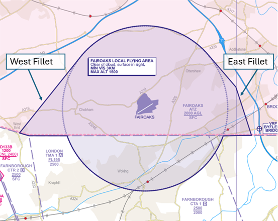
Figure 1 – UK AIP at EGTF AD 2.22.2
The LFA dimensions are promulgated in the UK AIP at EGTF AD 2.22.2
Outside the London CTR, the ATZ to the South extends from the surface to 2,080 feet AMSL and sits partly within the Farnborough CTA-1 (2,000 feet AMSL – 2,500 feet AMSL) (Figure 2).
Figure 2
Southerly ARRIVALS/DEPARTURES
Figure 3 – CAA/NATS 1:250,000 England South – Ed.29
Pilots arriving from or departing to the South, must remain outside of all controlled airspace unless they are in receipt of a clearance to enter from Farnborough Radar. It is essential that you remain below 2,000 feet (QNH) when inbound to and outbound from Fairoaks aerodrome.
Prior to flight, pilots should familiarise themselves with both the Worplesdon Railway Station (Figure 4) and Guilford Railway Station (Figure 5) Visual Reference Points (VRP).
Figure 4 – Worplesdon Railway Station VRP
Figure 5 – Guildford Railway Station VRP
When operating within the LFA, remain below 1,500 feet (QNH) in order not infringe the London CTR.
Inbound aircraft and circuit traffic should squawk 7010 when operating in the Fairoaks circuit and LFA/ATZ, unless informed otherwise.
On the leaving the LFA/ATZ to the South and/or operating around Farnborough, pilots are encouraged to obtain an Air Traffic Service (ATS) from Farnborough Radar on 125.250 MHz or to monitor 125.250 MHz and squawk the Frequency Monitoring Code of 4572.
DEPARTING RUNWAY 24
Do not delay your turn to the South on departure from Runway 24. The Farnborough CTR-2 (SFC -2,500 feet AMSL) is approximately 3NM south-west of Fairoaks.
DEPARTING RUNWAY 06
Do not delay your turn to the South on departure from Runway 06. Ensure your initial turn is made well before the M25.
It is essential that you operate on the Fairoaks QNH to avoid entering the Farnborough CTA-1 above. Ensure that climbs are arrested at 1,400 feet within the LFA and thereafter at 1,900 feet until clear of the Farnborough CTA-1 and you maintain a high level of monitoring of your altitude after departing the circuit, beneath the CTA.
Northerly ARRIVALS/DEPARTURES
Pilots planning to arrive from or depart to the North via the London CTR, must obtain a clearance to transit the London CTR.
For further information on routes, please refer to the Fairoaks – Pilots Guide.
In cases of thermic or windy conditions ensure an appropriate altitude below your clearance altitude is maintained so that the clearance limit is not breached and ensure you operate in accordance with the requirements of SERA.3105 Minimum heights.
It should be also noted that wake turbulence from aircraft making approaches to Heathrow Runway 09 may be encountered if transiting the London CTR between Ascot and Burnham.
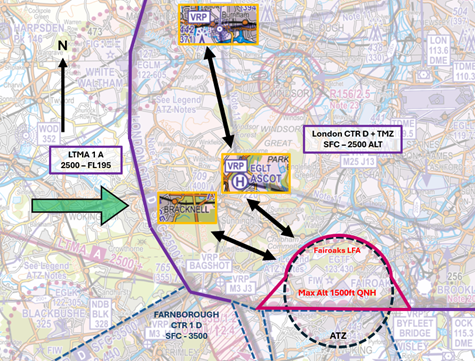
Figure 6 – CAA/NATS 1:250,000 England South – Ed.29
INBOUND LONDON CTR TRANSIT
Depending on departure point, pilots can request a routing from Bracknell, or Burnham VRP – Ascot VRP direct to Fairoaks, both of which may be a more expeditious routing than through Farnborough’s controlled airspace (Figure 6). A request to transit the London CTR must be made to Heathrow Radar 125.625 MHz
EXAMPLE RADIO TRANSMISSION
PILOT: “Heathrow Radar, G-ABCD, request Basic Service and zone transit via Bracknell”
HEATHROW RADAR: “G-ABCD, Heathrow Radar, pass your message”
PILOT: “G-ABCD, PA28, from Kemble to Fairoaks, 2NM West of Reading, altitude 2200 feet QNH 1023, VFR, tracking to Bracknell, request Basic Service and zone transit”
HEATHROW RADAR: “G-CD Roger, Heathrow QNH 1024 Basic Service, squawk XXXX, Report Wokingham”
PILOT: “Basic Service, QNH 1024, squawk XXXX, Wilco, G-CD”
PILOT: “G-CD Reporting Wokingham”
HEATHROW RADAR: “G-CD Roger, cleared to cross the London Control Zone, routeing Bracknell direct Fairoaks, not above altitude 1,200 feet, VFR”
PILOT: “Cleared to cross the London Control Zone, routeing Bracknell direct Fairoaks, not above altitude 1,200 feet, VFR, G-CD”
HEATHROW RADAR: “G-CD Read back correct”
You must not enter controlled airspace unless a clearance has been received
OUTBOUND LONDON CTR TRANSIT
Departing to the North, via the London CTR, plan to use the reverse of the routes described above (Figure 6)
Make your request to transit the London CTR to Fairoaks Radio who will communicate this with Heathrow. You can expect an interaction in the following format:
SCENARIO 1: Heathrow Radar will issue a clearance, which will be relayed by Fairoaks Radio, in the form of “G-ABCD, Heathrow Radar clears you to route to Bracknell, not above 1,200ft VFR, squawk XXXX, next frequency 125.625”
SCENARIO 2: Heathrow Radar requires you to remain within the LFA/ATZ until a clearance has been issued by Heathrow Radar. “G-ABCD, Heathrow Radar requires you remain within the Fairoaks LFA/ATZ, squawk XXXX, next frequency 125.625”
In either of the above scenarios, the initial call to Heathrow Radar would then simply be “G-ABCD squawking XXXX”
You must not enter controlled airspace unless a clearance has been received.
General Circuit Procedures
- Circuits direction is variable
- All procedures are based on the Fairoaks QNH
- Circuit altitude is 1,100 feet for fixed-wing aircraft and 800 feet for rotary aircraft
- Inbound aircraft and circuit traffic should squawk 7010 when operating in the Fairoaks circuit and ATZ/LFA unless otherwise informed
Joining
Fixed-wing aircraft should join the ATZ at 1,400 feet AMSL, and descend to 1,100 feet AMSL when North of the runway prior to turning:
- Downwind for Runway 06 left hand circuit.
- Crosswind for Runway 24 left hand circuit.
- Crosswind for Runway 06 right hand circuit.
- Downwind for Runway 24 right hand circuit.
‘Straight-in’, ‘downwind’ and ‘base’ joins are strongly discouraged when the circuit is active.
Rotary aircraft should enter the ATZ level at 800 feet AMSL and let down south of the runway.
The key to avoiding airspace infringements when operating to/from/at Fairoaks Aerodrome is to have a thorough understanding of the airspace structures and local operating procedures.
Prior to each flight into/from Fairoaks Aerodrome, review local procedures as part of your pre-flight planning. These are clearly explained at:
- United Kingdom AIP EGTF AD2.22 (Flight Procedures) (http://www.nats-uk.ead-it.com/)
- United Kingdom AIP EGLF AD2.17 (Air Traffic Services Airspace) (http://www.nats-uk.ead-it.com/)
- Fairoaks Airport website (Pilots Guide) (https://fairoaks.uk/downloads/)
Aircraft flying in the vicinity of Farnborough CAS
The Airspace & Safety Initiative website provides extensive advice on how to avoid the risk of infringing airspace. You are strongly encouraged to:
- Use a VFR Moving Map. In most of airspace infringements, pilots were either found not to be using a VFR Moving Map or not using one correctly. This was particularly evident during instructional flights where instructor workload is high and distractions highly likely. Using Moving Maps not only gives pilots a profile along the planned route showing controlled airspace above and below the route but it offers airspace warnings. Moving Map technology should not be the sole means of planning or navigation as highlighted in the European General Aviation Safety Team’s Safety Promotion Leaflet and the UK CAA Safety Sense leaflet.
- When flying in proximity to controlled airspace, and able to, pilots are strongly encouraged to apply the Take 2 guidance and operate on the most appropriate altimeter setting when operating under a CTA. In the case of the Farnborough CTA-1, the Fairoaks, Farnborough or London QNH are all acceptable. Consider increasing this distance in cases of thermic or turbulent conditions or where you lack experience or are subject to skill fade. The ‘Take 2’ initiative is neither a buffer based on State policy, nor is its application mandatory; it is merely guidance based on the principle of good airmanship, introduced by pilots to help their fellow pilots and other airspace users.
- Ensure a check of the aircraft’s transponder is conducted on the ground. In cases such as within the Fairoaks LFA whereby it is not possible to ‘Take 2’ whilst joining the fixed-wing circuit at 1,400 feet – ensuring that the transponder’s Mode C (ALT) information is accurate will avoid an erroneous display of an airspace infringement. Prior to the flight, set the altimeter to 1013 hPa and cross check against the transponder’s display. You must ensure the appropriate altimeter subscale setting for your flight is reset prior to departure.
- Understand the impact of forecast weather on your flight. Thermic or turbulent conditions can inadvertently push you upwards. Use the regulated Met Office Aviation Briefing Service in your planning. In addition, refer to Farnborough and Heathrow METARs/TAFs to better visualise local conditions and how they might affect your flight.
- Obtain a Lower Airspace Radar Service (LARS) from Farnborough Radar. Pilots departing Fairoaks and/or operating in the vicinity of Farnborough are encouraged to obtain a LARS from Farnborough Radar on 125.250 MHz; the hours of operation are listed in the UK AIP EGLF AD2.18 or subject to NOTAM action if different.
- Use the FMC rather than squawking 7000/2000. Pilots are encouraged to obtain an Air Traffic Service (ATS) from Farnborough Radar on 125.250 MHz or to monitor 125.250 MHz and squawk the Frequency Monitoring Code of 4572. Obtain the Farnborough QNH by listening to that given to other aircraft on 125.250 MHz. It may also be obtained from the Farnborough ATIS channel 128.405.
- Apply Threat and Error Management when planning and flying. Always consider airspace when making a detailed plan. Build in climb and descent points when routing in the vicinity of multiple CTAs with differing base altitudes. Know what VRPs look like and what airspace lies above them or close by. Identify a point beyond which you are not going to fly if you do not have a positive clearance to enter controlled airspace when departing Fairoaks when cockpit workload is high. A common causal factor in infringement occurrences is distraction; manage that Threat when operating close to controlled airspace.
- If appropriate – request a clearance from Farnborough Radar on channel 133.440. If a climb is required above the base of the CTA, a clearance must be obtained prior to entering.
White Waltham Aerodrome – Preventing infringements of the London CTR
This narrative has been written by the CAA Airspace Infringement Team in cooperation with members of the London Local Airspace Infringement Team.
White Waltham Aerodrome
White Waltham Aerodrome (EGLM) is situated approximately 12NM west of London Heathrow Airport. The aerodrome has a standard Aerodrome Traffic Zone (ATZ) of 2NM radius extending from the surface to 2,000 feet AAL (2,127 feet AMSL), with the eastern half situated within the London CTR. The Local Flying Area (LFA) is defined as that portion of the ATZ contained within the London CTR.
The MAXIMUM ALTITUDE for traffic within the LFA is 1,500 feet AMSL (QNH).
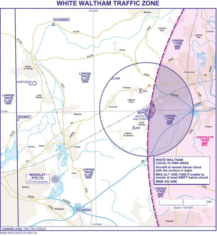
Figure 1 – UK AIP-AD 2.EGLM-4-1 WHITE WALTHAM TRAFFIC ZONE
Controlled Airspace
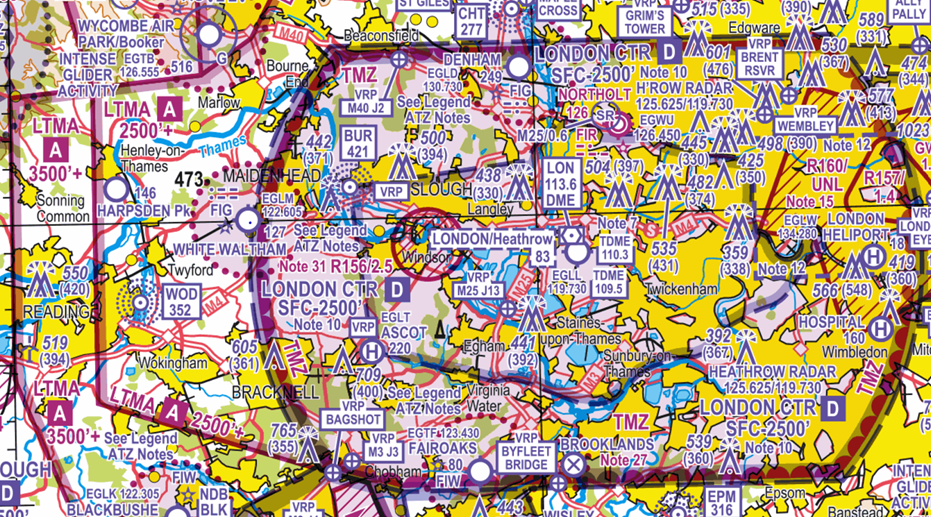
Figure 2: CAA 1:500,000 South – Edition.51
The London CTR extends from the Surface to 2,500 feet AMSL and is Class D airspace. The Class A London Terminal Control Area (LTMA-1) extends upwards from 2,500 feet AMSL to FL195.
White Waltham Aerodrome sits in close proximity to London Heathrow Airport, and any airspace infringement of the London CTR and/or the LTMA-1 has the potential to create an immediate safety impact and operational challenges. The location of the aerodrome places local traffic in close proximity to Heathrow arrival and departure routes, meaning every deviation outside the LFA into the CTR can quickly affect controller workload. Infringements around White Waltham carry a high risk of causing disruption, leading to losses of the required 3NM lateral and/or 3,000 FEET vertical separation (LoS) with Heathrow traffic and the implementation of Safety Intervention Measures (SIMs) (Avoiding Action, Vectors, Traffic Information, Stops/Checks on departures).
Effective Planning to Prevent Airspace Infringements
Arrival Procedures

Figure 3 Arrival Procedures
CONTROLLED AIRSPACE (LONDON TMA-1) SITS ABOVE ALL THE REPORTING POINTS FROM 2,500 FEET AMSL TO FL195
Arriving aircraft should contact ‘Waltham Radio’ on channel 122.605 and report their position in relation to, but not necessarily overhead, the appropriate published reporting points:
- November – Bend in the Thames, one mile northeast of Henley (also known as Henley Business School).
Tip: Inbound to White Waltham the Aerodrome is 133 degrees TT and 5NM from point November. - Whisky – Northern tip of the rowing lakes, Northeast of Reading.
Tip: Use the railway line as a guide. When routing inbound to White Waltham aerodrome from the west, the railway line guides you directly to the aerodrome. - Sierra – Junction 10 of the M4
Tip: Inbound to White Waltham from point Sierra, always remain North of the M4 Motorway.
Arrivals from the London CTR
Pilots operating on a VFR or Special VFR clearance in the London CTR inbound to White Waltham aerodrome (or otherwise) must not assume their CTR clearance permits entry to the ATZ.
If in doubt, speak to the operations team for a brief before departing.
DO NOT ENTER NOTIFIED AIRSPACE WITHOUT A CLEARANCE.
Departure Procedures
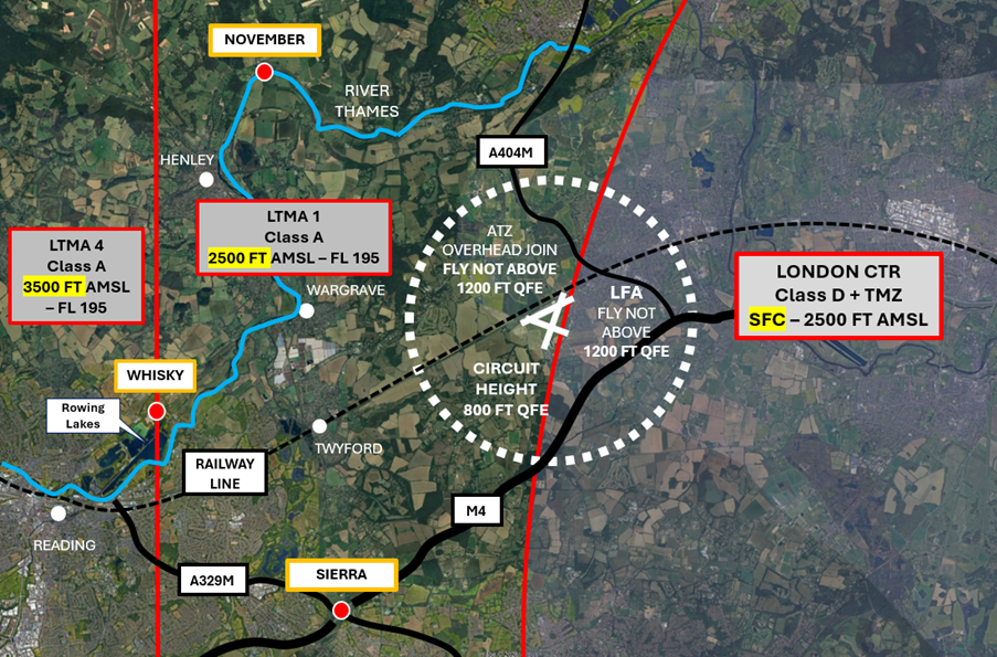
Figure 4 Departure Procedures
CONTROLLED AIRSPACE (LONDON TMA-1) SITS ABOVE ALL THE REPORTING POINTS FROM 2,500 FEET AMSL TO FL195
Follow the circuit pattern until the required departure leg is reached.
White Waltham aerodrome procedures are based on QFE. On departure, if not remaining within the circuit, use the London QNH, Waltham Radio will give this to you when calling on the ground for aerodrome information.
Departing into the London CTR
Pilots requiring a VFR or Special VFR clearance to transit the London CTR must remain within the confines of the White Waltham LFA until a clearance has been obtained from Heathrow Radar on frequency 125.525 MHz.
DO NOT ENTER CONTROLLED AIRSPACE WITHOUT A CLEARANCE
Fixed-Wing Circuit Procedures
CIRCUIT DIAGRAMS ARE LOCATED AT THE END OF THIS NARRATIVE DEPICTING RUNWAY/CIRCUIT SPECIFIC THREATS AND NOISE ABATEMENT
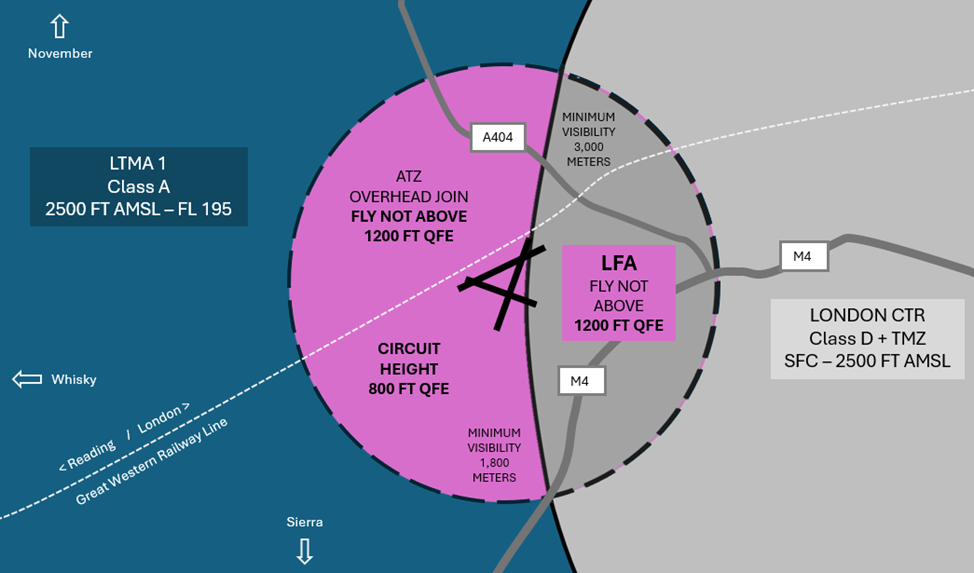
Figure 5 Fixed Wing Circuit Procedures
Fixed-wing circuits are flown left- hand except for Runways 29 and 07L and 07R, which are a right-hand circuit.
Tip: Except for a very small portion of the downwind leg for Runway 21 (Figure 9) ALL circuits should stay North of the M4 and West of the A404M
- All circuits are flown at 800 feet QFE
- Overhead joins are to be flown at 1,200 feet QFE
Conduct an assessment of the threats and errors of each circuit
If in doubt, speak to the operations team for a brief before departing.
Helicopter Routes
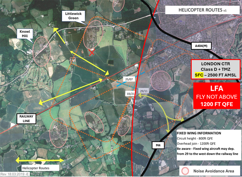
Figure 6 Helicopter Routes
Pilots of helicopters should remain clear of the fixed-wing circuit and approach the aerodrome below the circuit height of 800 Feet QFE.
Important Information – When calling Waltham Radio pilots of helicopters should prefix their callsign with ‘Helicopter’ on each transmission.
This avoids confusion and clearly lets others know that there is a helicopter operating in the vicinity. There are no designated taxiways on the aerodrome. All manoeuvres are at pilots’ discretion.
- Northern Helicopter Route – Approach the aerodrome between the villages of Knowl Hill and Littlewick Green
- Western Helicopter Route – Along the railway line
- Southern and Eastern Helicopter Routes – Along the M4 motorway and toward the Runway 29 Threshold
Pilots of helicopters joining via the Northern and Western Routes should aim to arrive on the aerodrome around the Runway 11 Threshold. If you are visiting Helicopter Services, please remain to the West of Runway 11/29.
Top Tips
- Even before taxiing or arriving via one of the published reporting points, you can start to build your situational awareness as to the aerodrome traffic environment intensity by maintain a listening watch on frequency.
- Make use of the radio. State your position and intentions to enhance situational awareness for all aircraft flying and to comply with Rule 11(3) of The Rules of The Air Regulations 2015.
- Be cognisant of the type of aircraft lining up to depart ahead of you. Consider delaying your departure to maintain spacing and proactively avoid the need to deviate from the published circuit patterns and/or going around.
- When planning (arrival, departure and in the circuit), set lateral and vertical limits, making use of prominent ground features (Railway line, A404M and M4) to help maintain situational awareness as to your position at all times.
- Consider the vertical limits of controlled airspace.
- Consider the wind direction and intensity:
- Ensure the aircraft is flown in accordance with published circuit procedures ground track.
- The runway in use might have changed from when you departed.
- Know your aircraft performance. Think density altitude. How will changes to the weather affect aircraft performance. Consider how you will manage the flight to remain within the LFA.
- Check your altimeter against your transponder to confirm the transponder is serviceable and operating within limits. Before taxiing, set your altimeter sub-scale to 1013 hPa (or 29.92 inHg), check the altitude displayed on your altimeter against the altitude transmitted by your transponder (Mode C/Altitude Reporting). The transponder should be within +/- 125 feet of your altimeter reading. After the check, remember to reset your altimeter to the correct QNH or QFE for departure.
Operational Information
For aerodrome operating hours visit the AIP. PPR is mandatory.
Waltham Radio – channel 122.605
Non radio aircraft are only permitted by prior arrangement and should check the signal square for runway direction before descending below 1,200 feet QFE.
Be aware that drone testing takes place at various locations within the aerodrome boundary up to a height of 400 feet AAL and may be taking place at the thresholds of runways not in use.
For more detailed information on arrival and departure procedures, visit the Pilot Information section at www.wlac.co.uk and/or call the operations team for a briefing on 01628 823272
Preventing an Airspace Infringement
To prevent an airspace infringement, as part of their pre-flight planning and in-flight execution, pilots are strongly encouraged to:
- Read the White Waltham Pilot Information. Available on the aerodrome website – www.wlac.co.uk
The White Waltham Pilot Information page contains details of the LFA, EGLM published reporting points, information relating to arrival/departure tracks and circuit and noise abatement procedures.
- Apply Threat and Error Management when planning and flying. Identify climb and descent points along your route and incorporate ‘Take 2’ wherever possible and mark these points on your chart and VFR Moving Map device as waypoints and incorporate them into your PLOG. Know which EGLM published reporting points are relevant to your flight and what they look like.
- Use a VFR Moving Map in conjunction with a regulated chart to allow you to cross-check your position in-flight. In many airspace infringements, pilots were either found not to be using a VFR Moving Map or not using one correctly. This was particularly evident during instructional flights where instructor workload is high and distractions highly likely. Using Moving Maps not only gives pilots a profile along the planned route showing controlled airspace above and below the route, but it offers airspace warnings. Moving Map technology should not be the sole means of planning or navigation as highlighted in the European General Aviation Safety Team’s Safety Promotion Leaflet and the UK CAA Safety Sense leaflet.
- Use the Farnborough West Frequency Monitoring Code (FMC). Use the FMC rather than squawking 7000/2000. Pilots are encouraged to obtain an Air Traffic Service (ATS) from Farnborough Radar on 125.250 MHz or to monitor 125.250 MHz and squawk the Frequency Monitoring Code of 4572. Obtain the Farnborough QNH by listening to that given to other aircraft on 125.250 MHz. It may also be obtained from the Farnborough ATIS channel 128.405.
- Wherever possible, ‘Take 2’ and remain 200 feet below or 2NM from the boundary of controlled airspace. Pilots are strongly encouraged to apply the Take 2 guidance and operate on the most appropriate altimeter setting. Consider increasing this distance in cases of thermic or turbulent conditions or where you lack experience or are subject to skill fade. The ‘Take 2’ initiative is neither a buffer based on State policy, nor is its application mandatory; it is merely guidance based on the principle of good airmanship, introduced by pilots to help their fellow pilots and other airspace users.
Circuit Diagrams
White Waltham OS Map Circuit 25 Left Hand
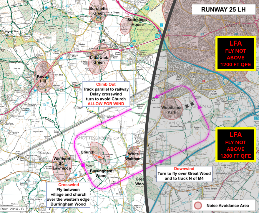
Figure 7 White Waltham OS Map Circuit 25 Left Hand
White Waltham OS Map Circuit 07 Right Hand
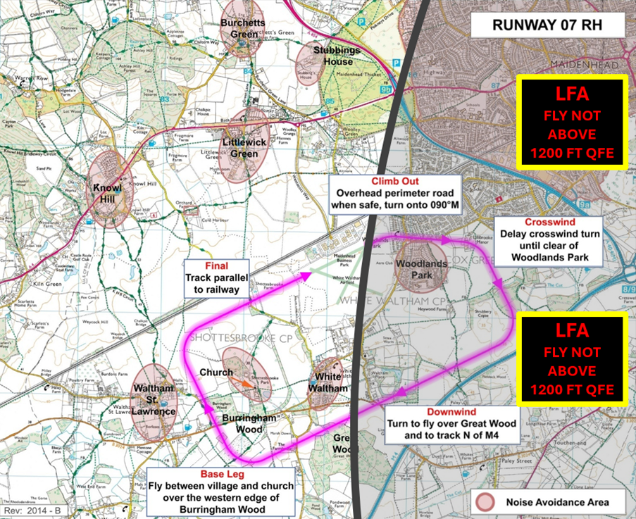
Figure 8 White Waltham OS Map Circuit 07 Right Hand
White Waltham OS Map Circuit 21 Left Hand
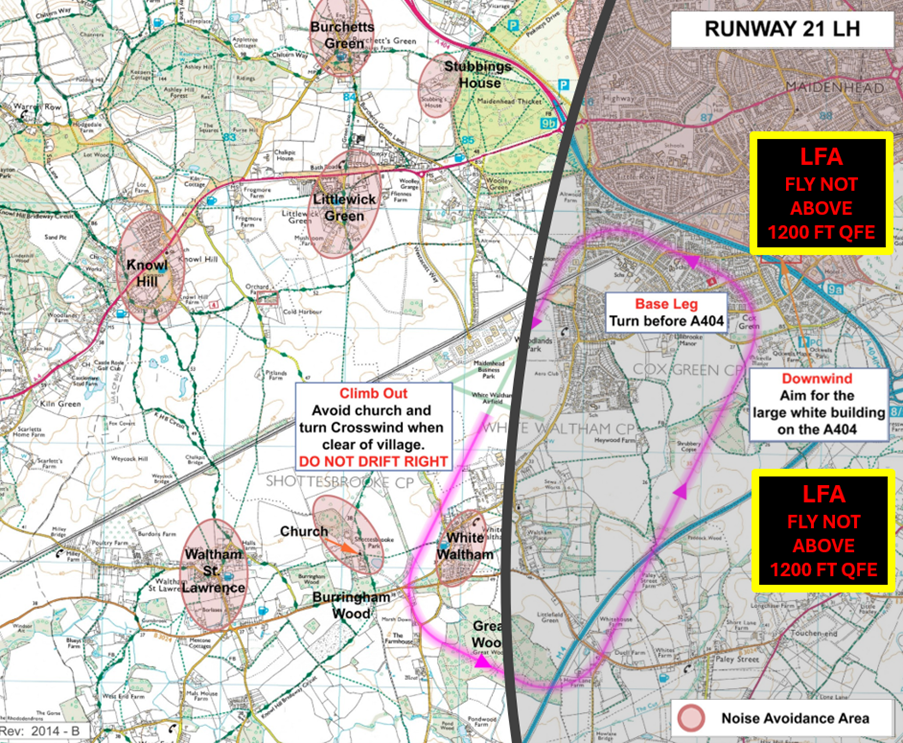
Figure 9 White Waltham OS Map Circuit 21 Left Hand
White Waltham OS Map Circuit 03 Left Hand
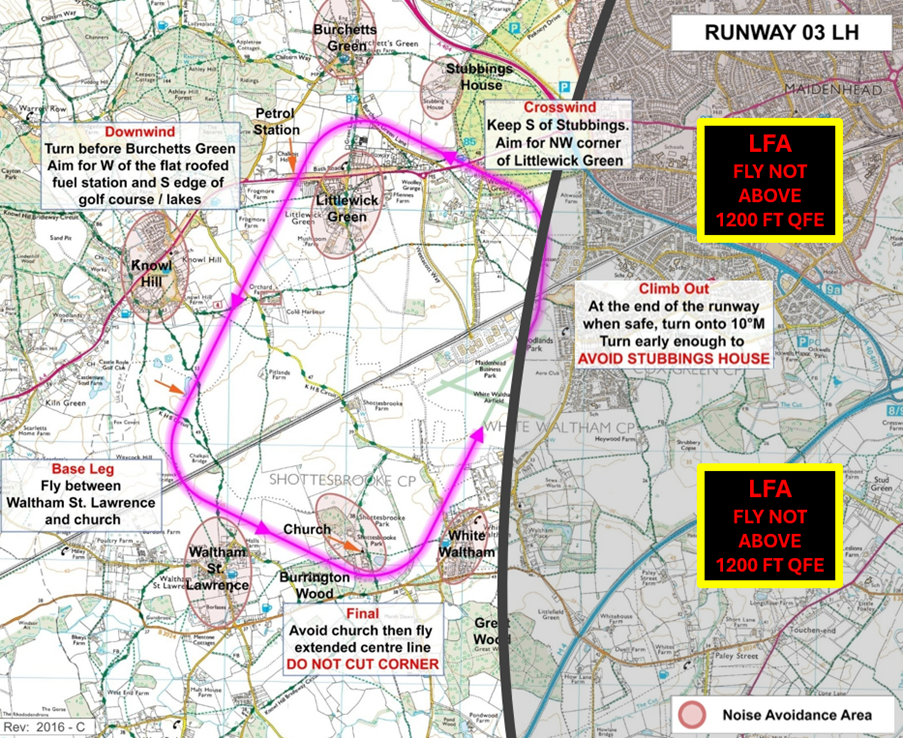
Figure 10 White Waltham OS Map Circuit 03 Left Hand
White Waltham OS Map Circuit 29 Right Hand
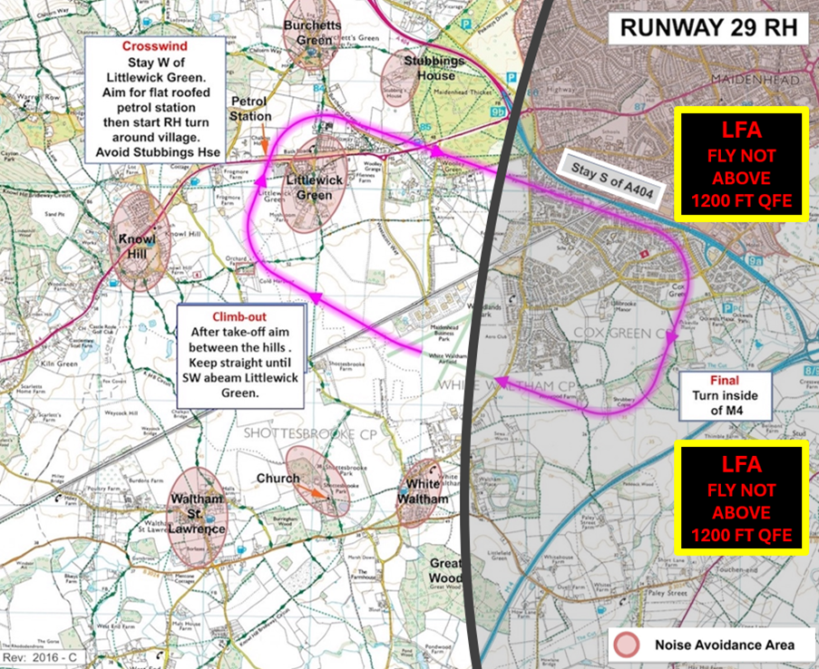
Figure 11 White Waltham OS Map Circuit 29 Right Hand
White Waltham OS Map Circuit 11 Left Hand
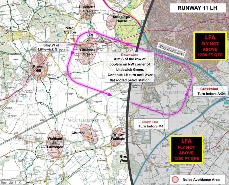
Figure 12 White Waltham OS Map Circuit 11 Left Hand