Guidance for pilots planning to fly in the vicinity of Farnborough has been developed in collaboration with the teams at Blackbushe and Fairoaks, Farnborough Air Traffic Service Unit and members of the LAIT. This content includes an occurence narrative, with pilot and air traffic control perspectives, hot-spot narratives introducing the CTA as well as focusing on CTA-1, Blackbushe and Fairoaks.
Infringement occurence
| Aircraft Category | Fixed-wing SEP |
| Type of Flight | Cross Country Recreational |
| Airspace/Class | Farnborough CTA / Class D |
Met Information
METAR EGLF Z XX1020Z 04013G24KT 360V060 9999 SCT022 06/M01 Q1025
METAR EGLF XX1050Z 06014KT 9999 SCT026 06/M01 Q1025
Air Traffic Control
The Air Traffic Controller reported operating as Farnborough West and Farnborough Zone band-boxed in busy traffic. The aircraft had been handed over from Farnborough LARS North requesting a Farnborough controlled airspace transit. The aircraft was asked to squawk Mode A 0460 (for Zone) and placed under a Basic Service. A transit clearance was issued routing Southwest of the Bagshot Mast to the Ockham VOR/DME (OCK), not above altitude 2,000 feet, VFR, remaining outside the London Control Zone (CTR). This was read back correctly after being challenged for an omission from the clearance in the initial read back.
Whilst monitoring the track of the aircraft, the service was changed from a Basic Service to a Radar Control Service as the aircraft entered LF CTR-1 southwest of the Bagshot Mast and then back to a Basic Service as the aircraft vacated the Farnborough CTR-2 in the vicinity of Woking. The aircraft requested to route via OCK after leaving Farnborough CTR-2 and was advised that they could resume their own navigation.
Whilst the aircraft was maintaining 1,900 feet beneath CTA-1 (base of 2,000 feet AMSL), the controller instructed the pilot to reset squawk 0435 (for LARS). The controller was imminently to issue advice that the aircraft was operating at the base of controlled airspace, as the aircraft’s altitude was observed to climb to 2,100 feet, which triggered an Airspace Infringement Warning (AIW) alert. The controller informed the pilot that they had entered controlled airspace and instructed them to descend to be not above 2,000 feet to remain outside. The pilot apologised and the aircraft was then observed to descend to leave controlled airspace.
Note: The Ockham VOR is no longer certified for en-route navigation. While its DME has a designated operational coverage (DOC) of 70NM, the VOR component is retained solely for terminal and approach procedures at select airports, including Heathrow.
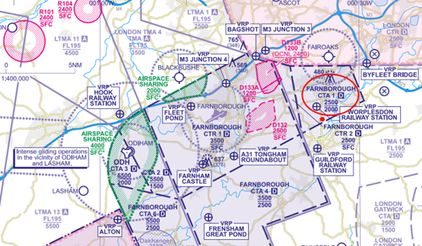
Figure 1: The aircraft entered the Class D CTA-1 indicating 2,100 feet where the base of controlled airspace is 2,000 feet AMSL.
Pilot
The pilot reported that they had planned to fly a route anticlockwise round the London CTR. The route had been planned on a VFR Moving Map as follows:
Bovingdon VOR/DME (BNN) – Woodley NDB (WOD) – Farnborough Airport (EGLF) Zone Transit – OCK
Figure 2: Route flown represented on the CAA/NATS 1:500,000 South – Ed.51
The pilot reported that a zone transit was sought through Farnborough’s CTR and granted not above 2,000 feet to the west of Bagshot mast. Once outside controlled airspace, approval was given to take up their own navigation direct OCK under a Basic Service. During this phase the pilot was advised they had climbed into controlled airspace, at which time they apologised and immediately descended. The pilot reports that from their VFR Moving Map log, it would suggest they had entered controlled airspace for approximately 2 minutes. The pilot stated that they encountered significant thermal activity when proceeding direct OCK necessitating power changes and inputs to maintain a constant altitude from time to time during the flight.
In discussion with the pilot post event
The pilot explained that this cross-country flight was conducted to maintain their currency and prevent skill fade. The pilot further explained that flying this route, around controlled airspace, was intended to not only help to maintain their flying skills but also allowed them to check that the aircraft’s avionics worked as expected.
In the lead up to the infringement, the pilot stated they were tracking direct OCK. It was at this time they experienced significant tail-lift pushing them up to 2,100 feet and thus infringing the Farnborough CTA-1. The pilot confirmed they were not using the aircraft’s autopilot. They further explained that it was whilst transiting initially beneath the CTA-1, they were tuning in to the Ockham VOR/DME.
The pilot expressed they wanted to remain as high as possible at all times whilst operating outside of controlled airspace in order to provide time to troubleshoot and perform a forced landing if necessary. Their rationale was based on having previously experienced 3 partial power losses. As a result, they had become normalised to fly at a higher altitude wherever possible. The pilot explained that they found cockpit workload inevitably increased when flying around the London CTR due to the extent of controlled airspace and ‘choke points’ around the area.
Findings/Causal Factors
The infringement occurred due to an inadvertent climb into the CTA when planning to fly 100 feet below the vase of controlled airspace due to thermic activity and possibly compounded by distraction when setting their VOR equipment. Whilst the pilot reacted quickly to the climb, the response was insufficient to prevent the aircraft entering controlled airspace as the aircraft was operated just below the base. However, a number of valuable lessons emerged from this occurrence which may be relevant to us all as pilots.
It was established that the event was underpinned by lapses in pre-flight planning, Threat and Error Management (TEM) and management of the flight.
The pilot is to be commended for their openness and post-occurrence actions. The pilot carried out post-flight analysis and commented on causal factors. As is the case in most occurrences there was not a single cause, several contributory factors led to how the infringement developed.
Pre-Flight Planning
Route planning
The pilot elected to fly 100 feet below the base of controlled airspace in thermic/turbulent conditions. Pilots are advised to maintain adequate separation from notified airspace through the application of the ‘Take 2’ guidance (where able, plan to remain at least 2NM from the edge or 200 feet below the base of the subject airspace) to avoid airspace infringements. The ‘Take 2’ initiative is neither a buffer based on State policy, nor is its application mandatory; it is merely guidance based on the principle of good airmanship, introduced by pilots to help their fellow pilots and other airspace users. If following this guidance places the pilot in an uncomfortable position, this is a threat, and should be addressed during the pre-flight planning stage, with potentially a less restrictive route decided upon.
Meteorology Planning
The pilot reported they encountered significant thermal activity when proceeding direct OCK necessitating power changes and inputs to maintain a constant altitude from time to time during the flight.
A thorough weather brief using regulated information from the Met Office Aviation Briefing Service website, for example Met Forms F214 and F215, should be completed prior to every flight and associated risks incorporated into the planned route. Local conditions can vary from what is forecast, reinforcing the advice to maintain adequate separation from notified airspace through the application of the ‘Take 2’ guidance. The recommended 200 feet distance may need to be increased during flights where turbulence or thermic conditions are encountered to prevent inadvertent climbs into controlled airspace.
Threat and Error Management (TEM)
Distraction
The pilot explained that whilst transiting beneath CTA-1, they were tuning in to the Ockham VOR/DME. Although it cannot be ascertained to what extent tuning into the VOR contributed to the infringement, operating proximate to controlled airspace and having just completed a zone transit and now prompted to reset the squawk, the pilot could have become task saturated. By not following the ‘Take 2’ guidance would further have reduced the pilot’s ability to remain below controlled airspace. In this instance, applying the ‘Aviate, Navigate, Communicate’ principle would have allowed the pilot to maintain their altitude relative to the base of controlled airspace. Thorough pre-flight planning would enable this threat to be identified, and the pilot could have planned to tune into the Ockham VOR/DME at a time where cockpit workload was low (prior to the Farnborough CTR transit).
VFR Moving Map
The pilot was using a VFR Moving Map application; however, it could not be ascertained what alerts were present, if any, and the response to them. When configured correctly VFR Moving Maps can not only enhance a pilot’s situational awareness in flight, but they can help to reduce confirmation bias and can also offer timely alerts to airspace and aviation hazards. Operating around controlled airspace will alert the pilot to controlled airspace proximate to their position (if configured correctly); however, there is a human factors element present whereby the pilot intuitively accepts/cancels the alert without having fully assimilated the information given. This can be especially true in cases where pilots are familiar with the airspace or are subjected to constant multiple alerts leading to ‘alert fatigue’. Every flight, even along routes previously flown, should be thoroughly planned, addressing the potential threats and errors for each phase of flight.
The CAA actively encourages pilots to use VFR Moving Maps in conjunction with the CAA/NATS Chart. However, VFR Moving Maps are not regulated by the CAA, and it is important to understand their limitations including differing depictions and altitude inaccuracies. They should not be used as your sole means of planning and navigation and a backup should be carried to prevent a loss of situational awareness should your device malfunction.
Summary
In conclusion, Human factors play a major role in many airspace infringements and in this case, the desire to remain as high as possible when flying outside of controlled airspace and distraction, resulted in the pilot inadvertently climbing into controlled airspace after the significant thermic conditions encountered. The pilot carried out effective post flight analysis and was open and honest about the occurrence in line with Just Culture.
Focus on
- Threat & Error Management
- Pre-flight Planning and Preparation
- Distraction and Interruption (CAA Safety Sense)
- Meteorology Planning (UK Met Office)
- VFR Moving Maps (CAA Safety Sense)
- ‘Take 2’ Initiative
Hot-spot narratives
Preventing airspace infringements in the vicinity of Farnborough Controlled Airspace
This infringement update has been written to provide pilots with a comprehensive guide to the Class D and Class E Farnborough controlled airspace to assist in the prevention of airspace infringements.
Farnborough Airport’s RNAV instrument flight procedures for departures and arrivals, utilising RNAV1 and RNAV5 navigation specifications are contained within controlled airspace (CAS) in the form of two Class D Control Zones (CTR) around the aerodrome, seven Class D Control Areas (CTAs) and two Class E Control Areas. The Class E airspace is a Transponder Mandatory Zone (TMZ). A speed limit of 250 knots IAS applies below FL100.
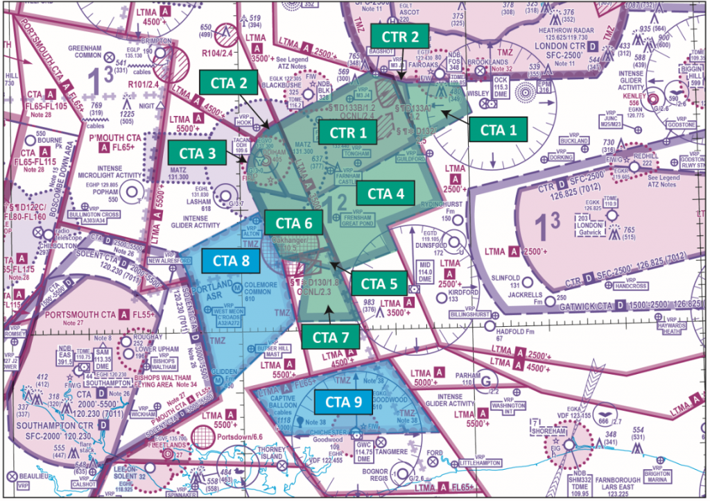
Figure 1: Farnborough CTR/CTA
| Structure | Vertical Limits | Classification |
| CTR 1 | SFC-3500 feet | Class D |
| CTR 2 | SFC-2500 feet | Class D |
| CTA 1 | 2000-2500 feet | Class D |
| CTA 2 | 1500-5500 feet | Class D |
| CTA 3 | 2000-5500 feet | Class D |
| CTA 4 | 2500-3500 feet | Class D |
| CTA 5 | 2500-4500 feet | Class D |
| CTA 6 | 2500-5500 feet | Class D |
| CTA 7 | 3500-4500 feet | Class D |
| CTA 8 | 4500-5500 feet | Class E with TMZ |
| CTA 9 | 5500 feet-FL65 | Class E with TMZ |
| Class A overlies CTA 9 at FL65 and above regardless of QNH | ||
Airspace access and responsibilities
Class D Controlled Airspace: CTRs 1 & 2, and CTAs 1 – 7
- IFR and VFR flights are permitted within all Class D airspace; SVFR flights are permitted in Class D CTR. An ATC clearance is needed and compliance with ATC instructions is mandatory.
- Aircraft operating IFR or SVFR are separated from each other and are given traffic information in respect of VFR flights, traffic avoidance advice is available upon request. Flights operating under VFR are given traffic information in respect of all other flights and traffic avoidance advice is available upon request.
Class D VMC Criteria (VFR Minima)
| Altitude Band | Flight Visibility | Distance from Cloud |
| Below FL100 and above 3,000 ft AMSL, or above 1,000 ft above terrain, whichever is the higher. | 5km | 1,500m horizontally and 1,000 feet vertically |
| At and below 3,000 ft AMSL, or 1,000 ft above terrain, whichever is the higher. | 5km | 1,500m horizontally and 1,000 feet vertically |
| Alternative, at and below 3000 ft AMSL when transiting class D airspace (flying at 140 kt IAS or less) and remaining outside the aerodrome traffic zone or aerodrome traffic circuit. | For aircraft, other than helicopters 5 km.
For helicopters 1,500 m |
Clear of cloud and in sight of the surface |
Class E Controlled Airspace: CTAs 8 & 9
- Class E airspace is controlled airspace. Compared with Class G airspace, there is a greater likelihood of encountering faster and heavier aircraft types within Class E airspace.
- IFR flights must obtain an ATC clearance to operate within Class E airspace as with other controlled airspace classifications.
- IFR flights are separated from other IFR flights and receive traffic information as far as practicable on VFR flights and when receiving a surveillance-based Air Traffic Service (ATS), traffic avoidance advice will be provided whenever practicable or when requested.
- ATS providers (Farnborough, London Terminal Control and Solent Radar) are not responsible for providing separation between IFR and VFR flights within the two Class E CTAs.
- Unlike other controller airspace classifications, pilots operating VFR are not issued with an ATC clearance to operate within Class E airspace.
- Pilots operating VFR within Class E airspace are not required to receive an Air Traffic Service, but it is recommended that such pilots seek to obtain a Basic Service or a Traffic Service (see CAP 774) from Farnborough ATC when operating in either CTA 8 or 9.
- Pilots of VFR flights are responsible for collision avoidance irrespective of whether an ATS (UK FIS) is provided.
- Farnborough Class E airspace is additionally notified as a Transponder Mandatory Zone (TMZ). Regardless of flight rules used, all aircraft within the TMZ must be equipped with Mode S transponders with altitude reporting, or if unable to meet the transponder requirements, obtain an approval (for lack of equipage) to enter TMZ airspace from the controlling ATS Unit prior to entry. An approval is not a clearance.
- Pilots intending to operating VFR within Class E airspace that is additionally notified as TMZ (i.e. CTA 8 & 9) must prior to entry either display:
- the appropriate Frequency Monitoring Code (FMC) for that volume of airspace; or
- the VFR conspicuity squawk (7000) with altitude reporting; or
- Pilots that are unable to meet the transponder requirements, should establish communication with the controlling ATS unit and obtain an approval to enter Class E airspace.
- Pilots may utilise the FMC for Solent (7011), Farnborough (4572) or Gatwick (7012) when monitoring the relevant frequencies within Class E airspace, however they must remain VFR at all times.
- Pilots already operating in accordance with VFR within CTAs 8 or 9 and subsequently wish to operate in accordance with IFR in these CTAs, must continue to operate VFR until an IFR clearance has been obtained.
Class E VMC Criteria (VFR Minima)
| Altitude Band | Flight Visibility | Distance from Cloud |
| Below FL100 and above 3,000 ft AMSL, or above 1,000 ft above terrain, whichever is the higher. | 5km | 1,500m horizontally and 1,000 feet vertically |
Controlled Airspace Transits
Pilots requesting to transit Class D airspace should call Farnborough Radar on channel 133.440 .
Pilots wishing to transit Class E airspace (CTA-8 and CTA-9) under VFR in communication with ATC should call Farnborough LARS on 125.250 MHz pilots wishing to transit under IFR should call Farnborough Radar on channel 133.440.
An aircraft that enters Class D airspace or Class E Airspace under IFR without a clearance is, to Air Traffic Control, considered to be an unknown aircraft and a separation standard of either 3NM laterally or 3,000 feet vertically must be achieved between that aircraft and IFR aircraft inbound to, or outbound from, Farnborough Airport.
Other Aerodromes
Blackbushe Airport lays to the north of CTR-1; part of its ATZ lies within the Class D CTR. Operational interactions with Farnborough Airport, and Local Flying Area procedures are specified in UK AIP AD2 EGLK-2.22 Flight Procedures.
(For more information on Blackbushe see ’19. Farnborough Controlled Airspace: Blackbushe Airport’)
Fairoaks Aerodrome IFR inbounds from the ATS route network will route via a Farnborough standard arrival route (STAR). Outbound aircraft will be managed in accordance with information specified in UK AIP AD2 EGTF-2.22 Flight Procedures. Fairoaks airfield southerly departures need to be aware of possible ACAS events against Farnborough IFR arrivals in CTA-1.
(For more information on Fairoaks see ’40. Focus on Fairoaks – Preventing Infringements in the vicinity of Farnborough’)
Farnborough controlled airspace may additionally include IFR operations from RAF Odiham, Lasham, Dunsfold, Goodwood and Shoreham aerodromes.
Royal Flights
A NOTAM will be issued to promulgate the reclassification of the Class E CTA-8 and/or CTA-9 as Class D CAS when Royal Flights are arriving/departing Farnborough aerodrome.
VFR pilots are to be aware of the change in airspace classification due to any Royal Flight activity in this area.
Visual Reference Points (VRPs)
When planning to transit any CAS, it is essential that as part of your pre-flight planning, you are aware of the VRPs relevant to that airspace, know what the VRPs look like and consider the likely routings and or/holding points that may be used employing them. In many infringement events it has been found that pilots do not know the location of many of the VRPs when relying upon them for point-to-point transits or as holding points. As part of pre-flight planning, use applications like Google Earth to familiarise yourself with that to expect to see on the ground and use your VFR chart to decide where and how you will hold if you are issued a clearance limit of one of the VRPs.
Farnborough has ten VRPs to assist in the provision of air traffic services to aircraft operating in the vicinity of Farnborough as follows:
M3 Junction 3 lies within the London Control Zone (CTR) and is clearly visible as the circular junction of the M3 and A322 (FIGURE 2).
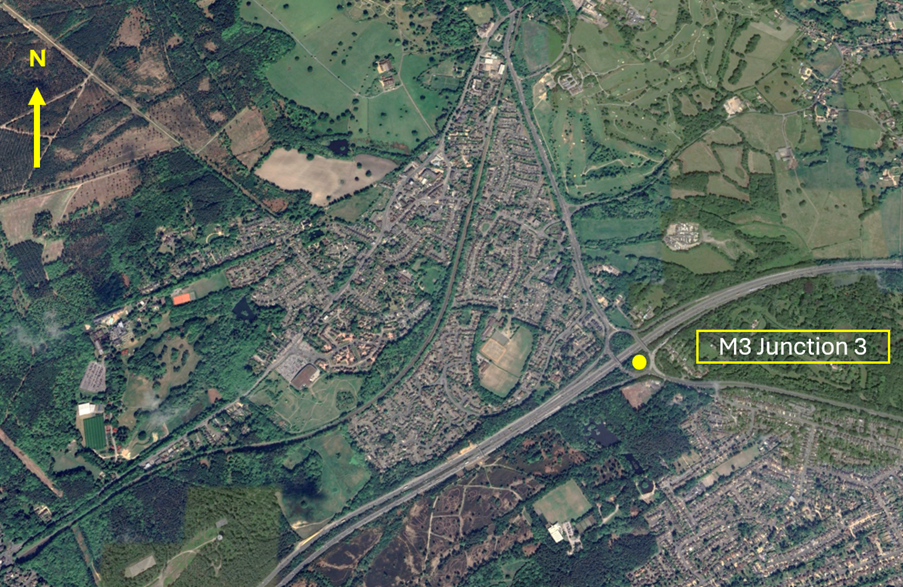
Figure 2 – M3 Junction 3 VRP
Bagshot VRP lies on the southwestern edge of the London CTR and is to the southwest of Bagshot town. When viewed from the air it is on the northside carriage of the M3 motorway on the portion of the road where the carriageways divide around a slip of woodland to the southwest of the M3 Junction 3. (FIGURE 3).
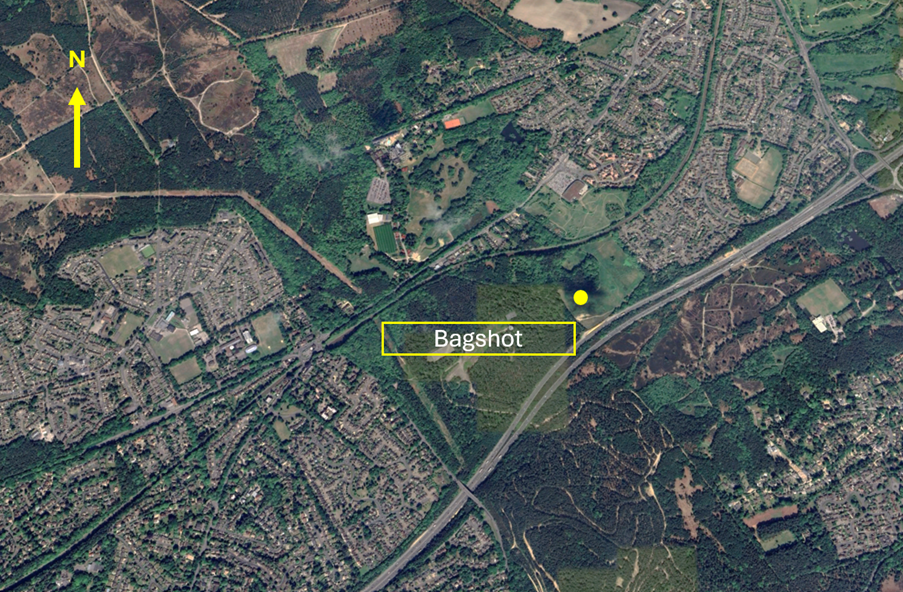
Figure 3 – Bagshot VRP
M3 Junction 4 lies within the Farnborough CTR-1 and is clearly visible between the towns of Frimley, Camberley and Farnborough (FIGURE 4). In addition to aircraft transiting north/south through Farnborough CAS, this VRP is used as a standard VFR departure from Blackbushe Airport not above 2,000 feet. When issued with a Standard M3 Junction 4 Departure by the FISO unit at Blackbushe Airport, you will be expected to hold north of the VRP and contact Farnborough Radar on channel 133.440.
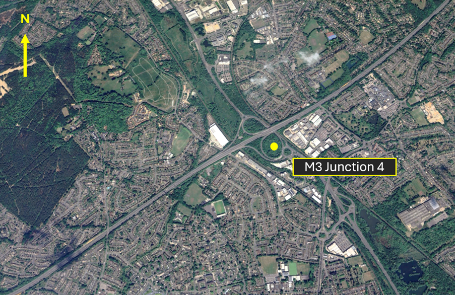
Figure 4 – M3 Junction 4 VRP
Fleet Pond VRP is the pond to the northwest of Farnborough Airport laying to the south of the M3 and inside the Farnborough CTR-1 (FIGURE 5). In addition to aircraft transiting East/West through Farnborough CAS, this VRP is also used as a standard VFR departure from Blackbushe Airport not above 2,000 feet. When issued with a Standard Fleet Pond Departure by the FISO unit at Blackbushe, you will be expected to hold northwest of the VRP and contact Farnborough Radar on channel 133.440.
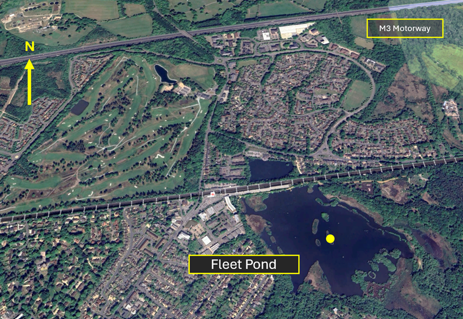
Figure 5 – Fleet Pond VRP
Hook Railway Station VRP can be identified as the bridge crossing the track at Hook railway station (FIGURE 6). It lays in Class G airspace to the northwest of the Farnborough CTR-1 and just to the north of the RAF Odiham ATZ.
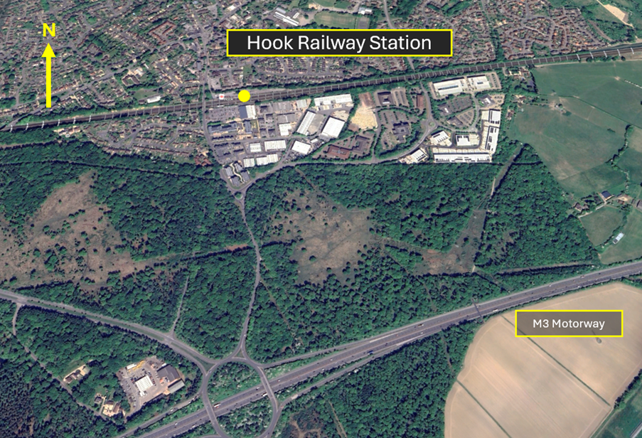
Figure 6 – Hook Railway Station VRP
Guildford Railway Station VRP is the railway station at Guildford (FIGURE 7). It lays in Class G airspace to the east of the Farnborough CTA-4 (2,500 feet to 3,500 feet AMSL) and to the south of CTA-1 (2,000 feet to 2,500 feet AMSL). When issued with a clearance limit at this VRP you should remain south and east of the town and River Wey to avoid entering the CTRs.
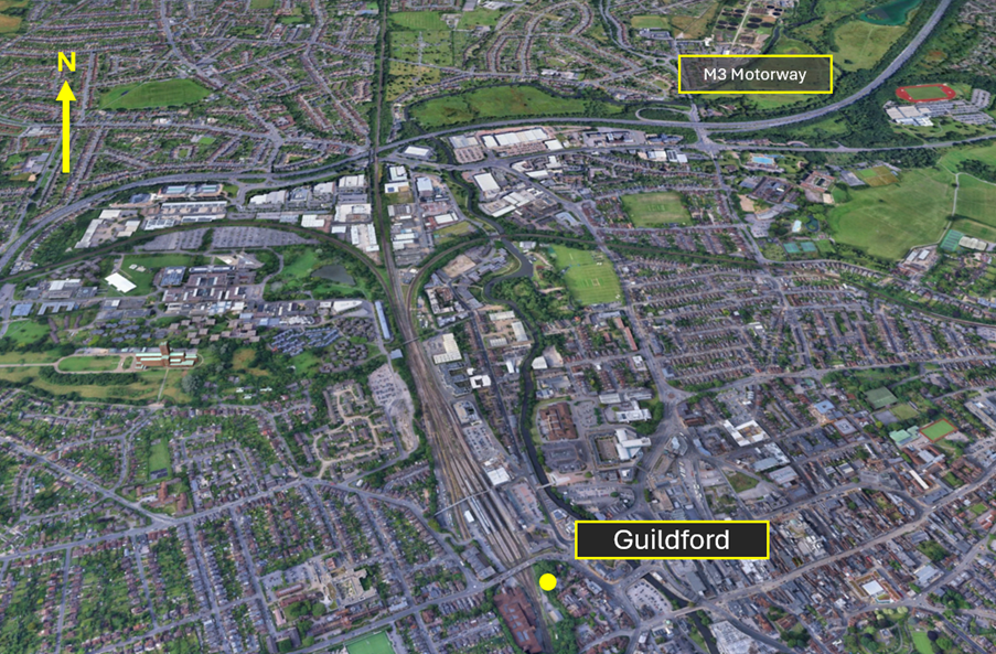
Figure 7 – Guildford Railway Station VRP
The A31 Tongham Roundabout VRP is the prominent traffic roundabout on the A31/A331 south of Aldershot and west of the part of the A31 known as the Hog’s Back (FIGURE 8). It is located within the Farnborough CTR-1.

Figure 8 – A31 Tongham Roundabout VRP
Approximately 2.5NM to the west southwest of the A31 Tongham Roundabout VRP, and also inside the Farnborough CTA-1 is the VRP of Farnham Castle (FIGURE 9). This VRP lays just to the north of Farnham and is a distinctive series of red brick/red roofed buildings with a building inside a walled grass circular area.
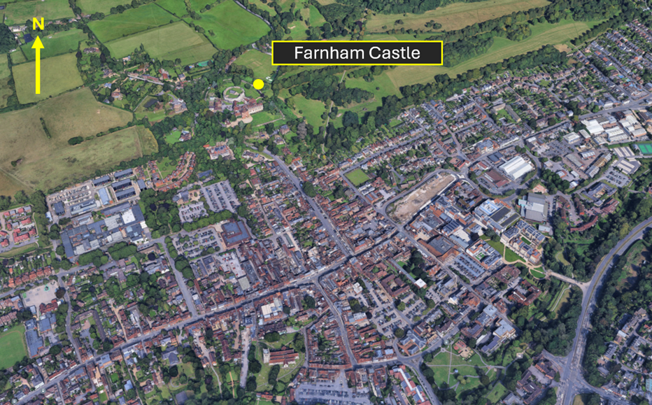
Figure 9 – Farnham Castle VRP
Underneath CTA-4 (2,500 feet -3,500 feet AMSL) lays the Frensham Great Pond VRP (FIGURE 10). It can be found midway between Haslemere and Farnham and on the western edge of the A287.
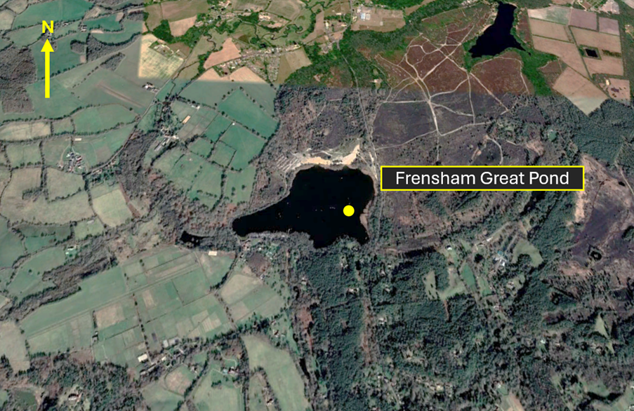
Figure 10 – Frensham Great Pond VRP
The final Farnborough VRP is the railway station at Alton (FIGURE 11). The town of Alton lays to the west of CTA-6 (2,500 feet – 5,500 feet) and on the southern edge of the RAF Odiham MATZ and approximately 3NM southeast of Lasham aerodrome. When planning to use this VRP, you should be aware of intense gliding with winch- launch activity up to 3,700 feet amsl (3,000 feet agl) at Lasham and the ATZ at RAF Odiham 3NM to the north.
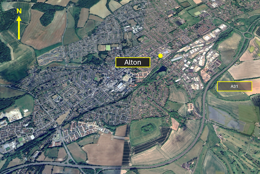
Figure 11 – Alton VRP
Obtaining and Reading Back of Clearances
The Skyway Code offers great guidance for increasing the chances of successfully obtaining a transit as follows:
Giving the controller reasonable time to respond to your request. Where possible, 10 minutes flying time from the intended entry point is ideal. If you are part of a planned ‘fly out’ where there are multiple aircraft looking to transit the airspace, apply good airmanship in considering the wider picture. SKYbrary defines airmanship as “the consistent use of good judgment and well-developed skills to accomplish flight objectives. This consistency is founded on a cornerstone of uncompromising flight discipline and is developed through systematic skill acquisition and proficiency. A high state of situational awareness completes the airmanship picture and is obtained through knowledge of one’s self, aircraft, environment, team and risk.” This can be achieved by:
- Staggering departures to allow time for each aircraft to arrive at the airspace at different times (why not allow plan for the faster aircraft to depart first?);
- Planning different holding areas in the event that clearances may take time to obtain and anticipate that the issuing of transit clearances will be subject to delay (this will also reduce the risk of mid-air collision);
- Remembering that other aircraft will also be looking to transit the airspace at the same time as your ‘fly out’. Today you may be one of 5 or 6 aircraft planning to cross the CTR, tomorrow you could be a flying on your own when there is another ‘fly out’ trying to do the same as you.
Sounding professional on the radio by clearly and concisely articulating your request. Use the standard format in Chapter 6: Approach Phraseology of CAP413- Radiotelephony Manual. This will give the controller the confidence that you can be relied on to comply with the conditions of the clearance. Remember that you cannot enter CAS until a clearance has been obtained and readback correctly. Part of the readback MUST include the flight rule under which you are operating. (FIGURE 12); a failure to readback the clearance verbatim will result in a request to read it back again thereby delaying the entry into CAS and will also add to frequency congestion.
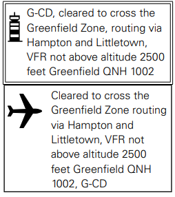
Figure 12
Plan for a transit that seems likely
If the controller is busy, it is unlikely that a transit that would be given that crosses the final approach track at a similar altitude to that of arriving aircraft. However, a transit high above the traffic flow at right angles is much more likely to work. Crossing through the aerodrome overhead or just downwind of the arrival threshold can often be accommodated.
If a transit is not forthcoming, positively alter course away from the airspace and monitor your Moving Map to ensure that you remain clear of the airspace. Knowing the airspace and associated VRPs is an essential part of pre-flight planning.
Aircraft Flying in the vicinity of Farnborough CAS
The Airspace & Safety Initiative website provides extensive advice on how to avoid the risk of infringing airspace. You are strongly encouraged to:
- Use a VFR Moving Map. In many airspace infringements, pilots were either found not to be using a VFR Moving Map or not using one correctly. This was particularly evident during instructional flights where instructor workload is high and distractions highly likely. Using Moving Maps not only gives pilots a profile along the planned route showing controlled airspace above and below the route, but it offers airspace warnings. Moving Map technology should not be the sole means of planning or navigation as highlighted in the European General Aviation Safety Team’s Safety Promotion Leafletand the UK CAA Safety Sense leaflet.
- When flying in proximity to controlled airspace, and able to, pilots are strongly encouraged to apply the Take 2 guidance and operate on the most appropriate altimeter setting when operating under a CTA. In the case of the Farnborough CTA-1, the Farnborough or London QNH are all acceptable. Consider increasing this distance in cases of thermic or turbulent conditions or where you lack experience or are subject to skill fade. The ‘Take 2’ initiative is neither a buffer based on State policy, nor is its application mandatory; it is merely guidance based on the principle of good airmanship, introduced by pilots to help their fellow pilots and other airspace users.
- Understand the impact of forecast weatheron your flight. Thermic or turbulent conditions can inadvertently push you upwards. Use the regulated Met Office Aviation Briefing Service; the site provides not only TAFs and METARs but Met Forms F214, F215, GAMETs and satellite imagery. In addition, refer to Farnborough and Heathrow METARs/TAFs to better visualise local conditions and how they might affect your flight.
- Obtain a Lower Airspace Radar Service (LARS)from Farnborough Radar. Pilots can obtain a LARS from Farnborough Radar in this area on 125.250 MHz; the hours of operation are listed in the UK AIP EGLF AD2.18 or subject to NOTAM action if different.
- Use the FMC rather than squawking 7000/2000. Pilots are encouraged to obtain an ATS from Farnborough Radar on 125.250 MHz or to monitor 125.250 MHz and squawk the Frequency Monitoring Code of 4572. Obtain the Farnborough QNH by listening to that given to other aircraft on 125.250 MHz. It may also be obtained from the Farnborough ATIS channel 128.405.
- Apply Threat and Error Management when planning and flying. Always consider airspace when making a detailed plan. Build in climb and descent points when routing in the vicinity of multiple CTAs with differing base altitudes. Know what VRPs look like and what airspace lies above them or close by. Have a point beyond which you are not going to fly if you do not have a positive clearance to enter controlled airspace. One of the biggest causes of infringements is distraction; manage that Threat when operating close to controlled airspace.
- If appropriate – request a clearance from Farnborough Radar on channel 133.440. If for any reason a climb is required above the base of the CTA, then a clearance must be obtained prior to entering the CTA.
This hot-spot narrative was updated in December 2025.
Preventing infringements of the Farnborough Controlled Airspace in the vicinity of Blackbushe Airport
This infringement update is the nineteenth in a series of narratives focusing on identified infringement hot-spots in the UK. It has been written by the team at Blackbushe Airport, Farnborough Air Traffic Service Unit and members of the Wessex Local Airspace Infringement Team.
Blackbushe Airport has a standard Aerodrome Traffic Zone (ATZ) of 2NM radius which extends from the surface to 2,325 feet AMSL (2,000 feet AAL). Part of the Blackbushe ATZ lies within the Class D Farnborough Control Zone (CTR-1). The area of overlap between the Blackbushe ATZ and Farnborough CTR-1 forms the Blackbushe LFA. The LFA extends to 2,000 feet AMSL (1,675 feet AAL) and its dimensions are promulgated in in the UK AIP at AD2.22.4 LOCAL FLYING AREA. It is shown in Figure 2 which is published on the Blackbushe Airport website at www.blackbusheairport.co.uk/aerodrome.
SVFR operations within the LFA require a clearance from Farnborough Radar, and are required to be separated from other SVFR/IFR aircraft. As a result, issuance of such a clearance from Farnborough Radar would be available to only one aircraft at a time.
Additional conditions apply when operating under special VFR. See EGLK AD 2.22.5 SPECIAL VFR IN THE LOCAL FLYING AREA.

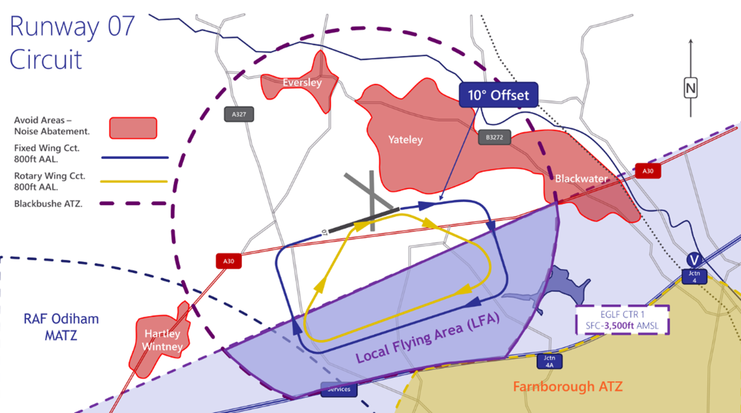
Blackbushe LFA
Aircraft JOINING/OPERATING in the Blackbushe Visual Circuit
Runway 25
The majority of the airspace infringements to date have resulted from pilots extending downwind in the Runway 25 visual circuit (Figure 3) and leaving the LFA in the vicinity of Hawley Lake. The AIP entry for the LFA states “Pilots are required to contain their circuits within the LFA and ATZ. In particular, on Runway 25 note to turn base leg west of Hawley Lake (Figure 4) to avoid infringing the CTR to the east.” In addition, on the Blackbushe Airport Information page pilots are advised to “Turn Base Leg before reaching Hawley Lake (Figure 4) to ensure circuits remain inside the ATZ/LFA. If aircraft ahead are establishing a wider circuit, do not follow, but reposition deadside or orbit as appropriate, and in communication with ATSU.”
If the visual circuit is extending to the east and there is a possibility that you might leave the LFA, make a positive, early decision to reposition deadside for another circuit; DO NOT extend over or to the east of Hawley Lake.

Blackbushe Runway 25
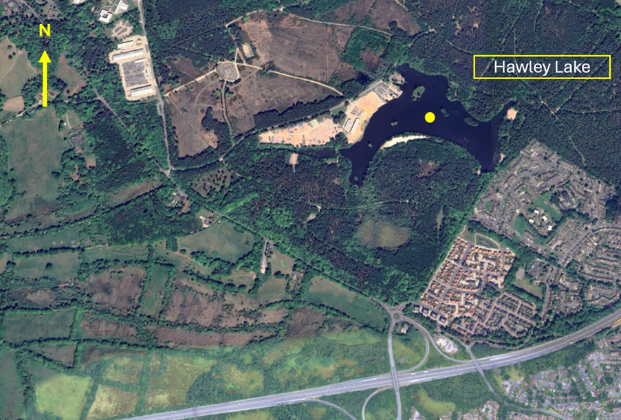
Hawley Lake
Runway 07
When joining for Runway 07 turn base leg when joining or descending deadside, take care to remain west of Yateley. Follow the path of disused runway 14/32, keeping it to the left at all times.
Turn Base Leg before reaching The Elvetham Hotel (and abeam Fleet Services) (Figure 6) to ensure circuits remain inside the ATZ/LFA. If aircraft ahead are establishing a wider circuit, do not follow, but reposition deadside or orbit as appropriate, and in communication with ATSU.
Blackbushe Runway 07
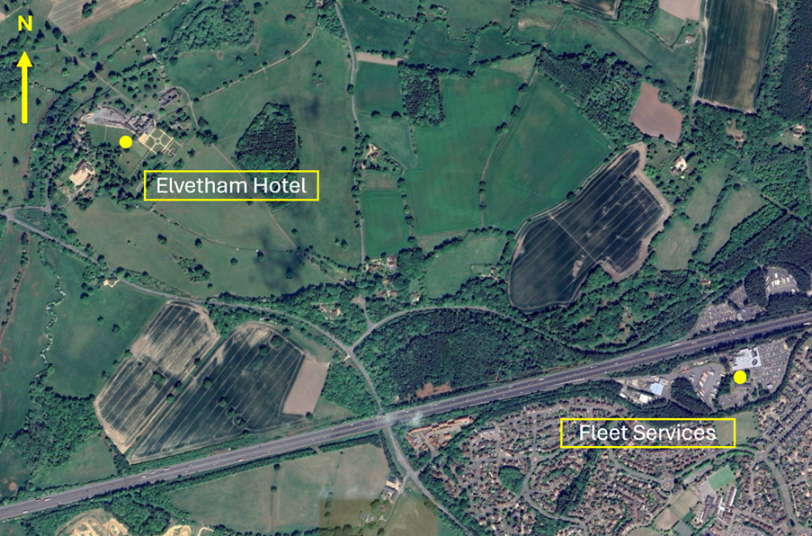
Elvetham Hotel and Fleet Services
If you are re-joining the circuit, you must ensure that you are squawking 7010 prior to entering the LFA. Where you are entering the LFA from the south (within the Farnborough CTR-1), you may either retain the squawk issued for your transit, or select 7010 once North of the M3.
General Circuit Procedures
Circuit Procedures
- Circuits are always to the south of the Airfield and are flown at 800 feet QFE for most fixed wing aircraft.
- For jet, turbo-prop, or other high-performance traffic, circuits are flown at 1,200 feet QFE.
- Rotary wing circuits are flown at 800 feet QFE typically inside the fixed wing circuit. All pilots should be aware of rotary traffic using non-standard circuits when using the Helicopter Training Area to the south of Runway 07/25.
- Pilots must remain north of the M3 motorway to avoid infringing the Farnborough ATZ/CTR.
- In the interests of safety, orbits in the circuit are generally not permitted, but may be required on occasion due to the range of aircraft with different performance characteristics. Should orbits be required they should first be declared, and then be executed in the direction of the circuit.
- Unless in an emergency, aircraft must observe the Rules of the Air for aerodromes at all times.
Aircraft DEPARTING Blackbushe Airport
Another area in which airspace infringements have occurred are during the departure phase, in particular from Runway 07 where a ‘wrap around’ departure is required to avoid the noise abatement areas associated with Yateley. The Blackbushe airport website gives clear guidance as follows.
Runway 25 Departures
“If departing to the North or West, straight out departures are permitted with a right turn to avoid overflying Hartley Wintney (Figure 7) and avoid entering controlled airspace to the South.
If departing to the Southwest, South or East, a clearance must be sought to enter the Farnborough CTR/CTA”.
Runway 07 Departures
“On climb out, a turn 10° to the south must be made to avoid Yateley.
Unless in an emergency, all turns must be to the south. To leave the circuit, climb on the downwind leg into the overhead, remaining outside controlled airspace by remaining below 2,000 feet AMSL (1,675 feet AGL) unless in receipt of a clearance from Farnborough Radar.”
The important point to note to avoid infringing the Farnborough CTR-1 is that departing aircraft must maintain below 2,000 feet AMSL (1,675 feet AGL) until clear of the lateral confines of the LFA to the west and north. Care must be taken when departing to the southwest not to inadvertently enter the CTR if you are not in receipt of an air traffic clearance to enter the CTR.
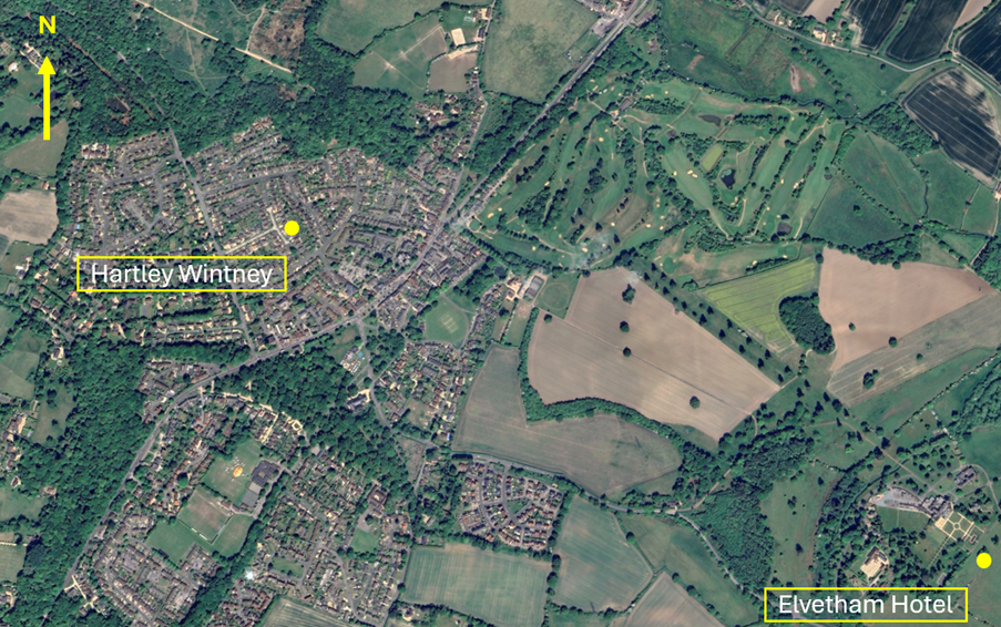
Hartley Wintney
Preventing an airspace infringement when operating at Blackbushe Airport
The key to avoiding airspace infringements when operating to/from/at Blackbushe is to have a thorough understanding of the airspace structures and local operating procedures.
When operating in the Blackbushe circuit always remain in the LFA.
When flying downwind for Runway 25, turn base leg before reaching Hawley Lake. If the aircraft ahead of you is flying wide circuits, go around early and reposition for another circuit.
When flying downwind for Runway 07, turn base leg before the Elvetham Hotel (abeam Fleet Services).
When departing from Runway 07, turn right downwind and remain below 2000 feet AMSL (1675 feet AGL) until clear of the LFA.
Prior to each flight into/from Blackbushe, review local procedures as part of your pre-flight planning. These are clearly explained at:
- United Kingdom AIP EGLK AD2.22 (Flight Procedures) (http://www.nats-uk.ead-it.com/)
- Blackbushe Airport website (Pilot Information) (https://www.blackbusheairport.co.uk/aerodrome)
- Airspace and Safety Initiative website (Hot-spot narrative and Local Airspace Infringement Teams – Narrative 10 ) (https://airspacesafety.com/local-area-information/)
Aircraft Flying in the vicinity of Farnborough CAS
The Airspace & Safety Initiative website provides extensive advice on how to avoid the risk of infringing airspace. You are strongly encouraged to:
- Use a VFR Moving Map. In many airspace infringements, pilots were either found not to be using a VFR Moving Map or not using one correctly. This was particularly evident during instructional flights where instructor workload is high and distractions highly likely. Using Moving Maps not only gives pilots a profile along the planned route showing controlled airspace above and below the route, but it offers airspace warnings. Moving Map technology should not be the sole means of planning or navigation as highlighted in the European General Aviation Safety Team’s Safety Promotion Leaflet and the UK CAA Safety Sense leaflet.
- When flying in proximity to controlled airspace, and able to, pilots are strongly encouraged to apply the Take 2 guidance and operate on the most appropriate altimeter setting when operating under a CTA. In the case of the Farnborough CTA-1, the Farnborough or London QNH are all acceptable. Consider increasing this distance in cases of thermic or turbulent conditions or where you lack experience or are subject to skill fade. The ‘Take 2’ initiative is neither a buffer based on State policy, nor is its application mandatory; it is merely guidance based on the principle of good airmanship, introduced by pilots to help their fellow pilots and other airspace users.
- Understand the impact of forecast weatheron your flight. Thermic or turbulent conditions can inadvertently push you upwards. Use the regulated Met Office Aviation Briefing Service; the site provides not only TAFs and METARs but Met Forms F214, F215, GAMETs and satellite imagery. In addition, refer to Farnborough and Heathrow METARs/TAFs to better visualise local conditions and how they might affect your flight.
- Obtain a Lower Airspace Radar Service (LARS)from Farnborough Radar. Pilots can obtain a LARS from Farnborough Radar in this area on 125.250 MHz; the hours of operation are listed in the UK AIP EGLF AD2.18 or subject to NOTAM action if different.
- Use the FMC rather than squawking 7000/2000. Pilots are encouraged to obtain an Air Traffic Service (ATS) from Farnborough Radar on 125.250 MHz or to monitor 125.250 MHz and squawk the Frequency Monitoring Code of 4572. Obtain the Farnborough QNH by listening to that given to other aircraft on 125.250 MHz. It may also be obtained from the Farnborough ATIS channel 128.405.
- Apply Threat and Error Management when planning and flying. Always consider airspace when making a detailed plan. Build in climb and descent points when routing in the vicinity of multiple CTAs with differing base altitudes. Know what VRPs look like and what airspace lies above them or close by. Have a point beyond which you are not going to fly if you do not have a positive clearance to enter controlled airspace when departing from Fairoaks or Blackbushe Airport when cockpit workload is high. One of the biggest causes of infringements is distraction; manage that Threat when operating close to controlled airspace.
- If appropriate – request a clearance from Farnborough Radar on channel 133.440. If for any reason a climb is required above the base of the CTA, then a clearance must be obtained prior to entering the CTA.
This hot-spot narrative was updated in December 2025.
Preventing infringements of Farnborough CTA-1
Farnborough CTA-1 has been identified as an infringement hot-spot. This narrative has been written by the team at Fairoaks Airfield and at the Farnborough Air Traffic Service Unit. Its aim is to not only help pilots understand the airspace, but also the safety impact of infringements and the additional impact on LARS service provision.
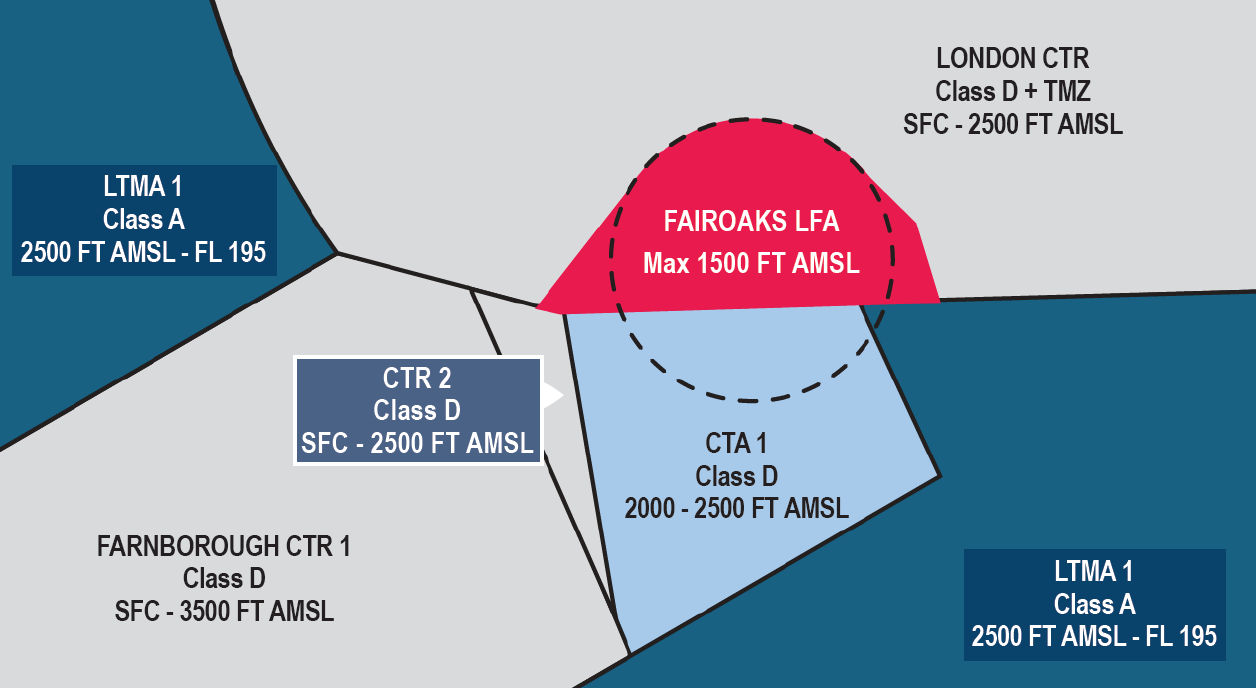
Figure 1
The Farnborough CTA-1 extends from 2,000 feet to 2,500 feet AMSL (Figure 1)
Pilots should take particular note of Control Zone 2 (CTR-2) that is adjacent to CTA-1 and extends from the surface up to 2,500ft AMSL. This small fillet of Class D airspace has a lower upper limit than the CTR-1 due to the lower base on the Class A London Terminal Control Area (TMA) above it.
IFR and VFR entry is subject to a clearance from Farnborough ATC. Requests for transit/entry clearance should be made on the Farnborough Radar channel 133.440.
You must not enter controlled airspace unless a clearance has been received.
If your intention is to remain outside controlled airspace whilst operating proximate to controlled airspace, it is good practice to consider obtaining an air traffic service from Farnborough Radar on 125.250 MHz or select the Frequency Monitoring Code (FMC) of 4572 and maintain a listening watch on 125.250 MHz.
Visual Reference Points (VRPs) in the vicinity of CTA-1
Pilots operating in the vicinity of CTA-1 should familiarise themselves with the following VRPs (Figures 2,3 and 4).
Pilots may be instructed to hold at one of the VRPs as part of a Class D transit clearance.
Pilots transiting the Class G airspace below CTA-1 should be aware of the Fairoaks Aerodrome Traffic Zone (ATZ) and other traffic operating in and out of Fairoaks aerodrome.
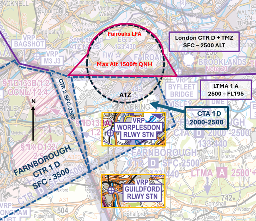
Figure 2 – CAA/NATS 1:250,000 England South – Ed.29
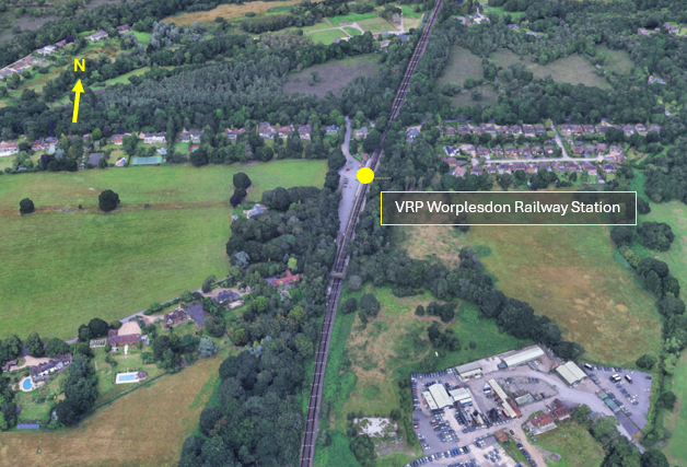
Figure 3 – Worplesdon Railway Station) VRP
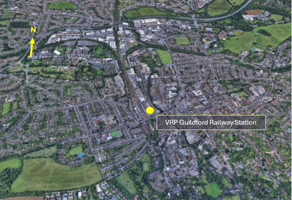
Figure 4 –Guildford Railway Station) VRP
Controlled Airspace Transits
To better understand why a transit might be denied, under what circumstances they are given, and, any conditions that might be attached to such a clearance, refer to the next section on Farnborough Operations.
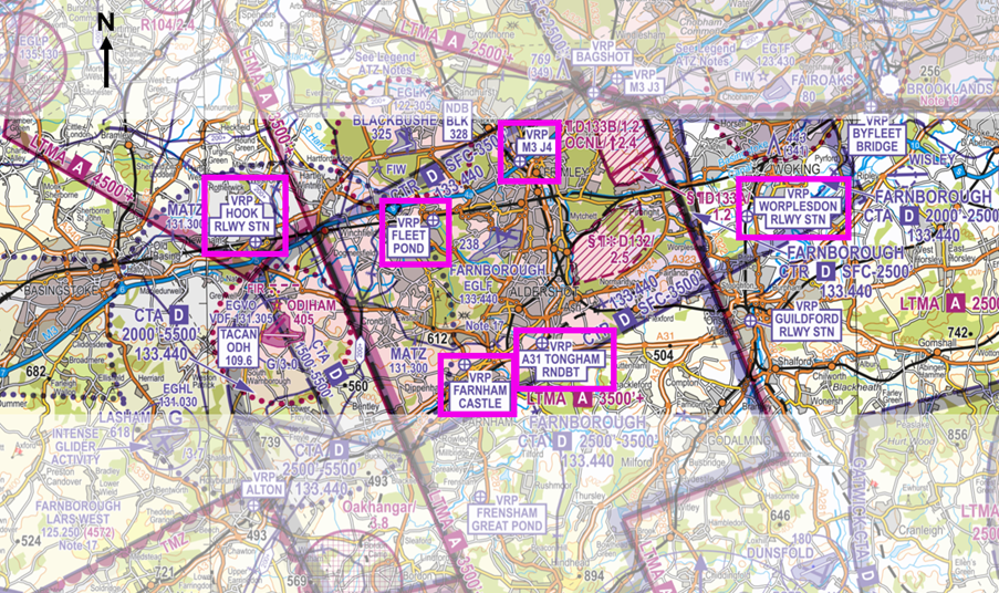
Figure 5 – CAA/NATS 1:250,000 England South – Ed.29
East/West (British Rail) (Hook/Woking)
Pilots wishing to route east/west or vice versa through Farnborough’s controlled airspace can typically expect a routing following the railway line between Hook Railway Station VRP (Figure 6) and Worplesdon Railway Station VRP (Figure 3) (commonly called ‘British Rail east/west’). If this route is unavailable due to IFR traffic, an alternative routing may be offered via the A31 Tongham Roundabout VRP (Figure 7) and Farnham Castle VRP (Figure 8).
Note: Pilots routing west to east on the railway line routing may be given a clearance limit of the Fleet Pond VRP (Figure 9) due to IFR traffic inbound runway 24. When approaching the Fleet Pond VRP onward clearance via the M3J4 VRP (Figure 10) may be issued instead to deconflict against IFR traffic on final approach.
North/South
Pilots wishing to route north/south or vice versa through Farnborough’s controlled airspace can typically expect a routing via the M3J4 VRP and the A31 Tongham Roundabout VRP or the Fleet Pond VRP and the Farnham Castle VRP. The routing offered will normally depend on runway in use and traffic operations.
Note: Pilots may be given a clearance limit to a VRP to enable safe integration with IFR traffic. The controller will provide traffic information on relevant IFR traffic to enable the pilot of the transit aircraft to become visual with the traffic and allow for an onward clearance to be issued with the traffic in sight.
Northwest/Southeast
Pilots wishing to route Northwest/Southeast or vice versa through Farnborough’s controlled airspace can typically expect a routing southwest of the Bagshot Mast (Figure 11) to the Worplesdon Railway Station VRP (remaining southwest of the Bagshot Mast will ensure you remain outside the London CTR). Pilots should be aware of the Fairoaks ATZ and other traffic operating into and out of Fairoaks.
A thorough knowledge of the VRPs associated with Farnborough CAS will better equip you for any changes to your planned routing and reduce the likelihood of an infringement.
Visual Reference Points (VRPs)
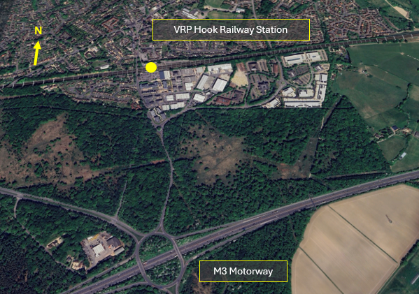
Figure 6 – Hook Railway Station) VRP
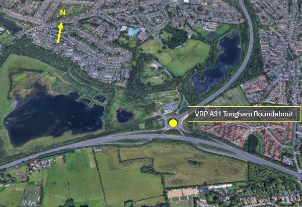
Figure 7 – A31 Tongham Roundabout) VRP
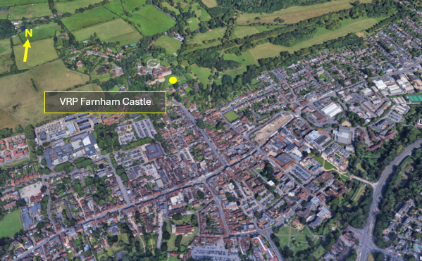
Figure 8 – Farnham Castle VRP
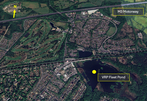
Figure 9 – Fleet Pond VRP
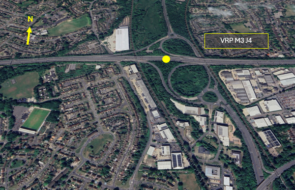
Figure 10 – M3 J4 VRP
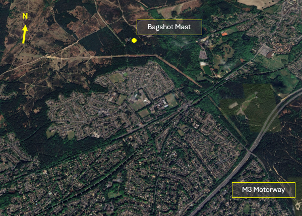
Figure 11 – Bagshot Mast
Farnborough Operations
CTA-1 infringement Hot-Spot
The Farnborough CTA-1 is a small portion of airspace (of only 500 feet) that sits below the base of the London TMA. Farnborough standard arrival (STAR) and standard instrument departure (SID) profiles are specifically designed to ensure safe integration with Heathrow Airport and Gatwick Airport departures.
Farnborough Runway 24
IFR traffic on approach to Runway 24 routes through CTA-1 on a base leg heading, descending to 2,500 feet AMSL. IFR inbound aircraft are required to be 3,000 feet AMSL or below to ensure separation against Heathrow Airport Runway 27 departures.
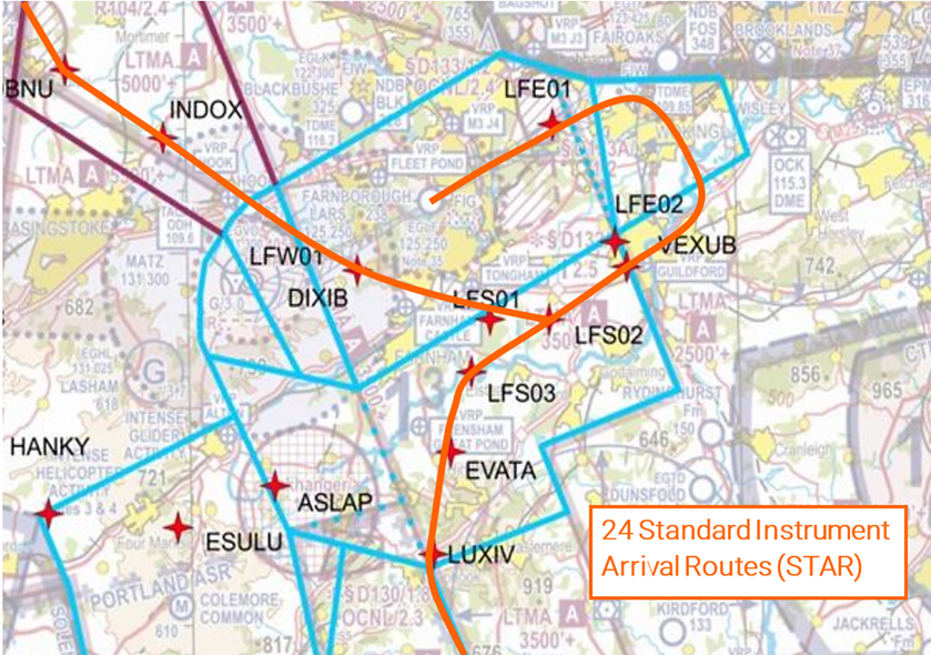
Figure 12 – Runway 24 Standard Instrument Arrival Routes – STAR
If an infringement of CTA-1 occurs when Farnborough is operating on Runway 24, ATC and aircraft can be impacted as follows:
- Loss of prescribed separation between aircraft, resulting in removal of the controller from operations.
- Resolution advice – such as avoiding action – to maintain separation.
- Delay to airborne aircraft – due to extended vectoring to avoid an infringing aircraft.
- Increased workload for all
Farnborough Runway 06
IFR traffic departing Runway 06 routes through CTA-1 on climb out following the SID profile, climbing to 3,000 feet AMSL. Aircraft are required to depart on the runway heading before commencing turn for noise abatement and to avoid EG D132 Ash Ranges.
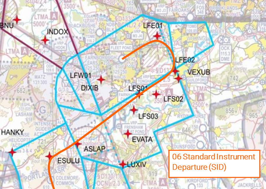
Figure 13 – Runway 06 Standard Instrument Departure – SID)
If an infringement of CTA-1 occurs on easterly operations, the impacts as above can be further complicated by the requirement to avoid EG D132 and departing aircraft operating at lower levels; aircraft on the ground may also be delayed if departure clearances are cancelled.
Example of how an infringement of CTA-1 can affect Farnborough operations whilst Runway 06 is in use:
- After departing Fairoaks Runway 24, a GA aircraft routing on a southerly track, entered Farnborough CTA-1 without a clearance, climbing to 2,100 feet where the base of controlled airspace is 2,000 feet AMSL. The infringement resulted in a loss of separation against a Farnborough IFR departure off Runway 06 which was following the SID. The Farnborough Approach Controller issued avoiding action to the Pilot of the Farnborough traffic and passed traffic information on the infringing traffic.
- Immediately prior to the infringement, the pilot of the GA aircraft called Farnborough LARS West advising they were climbing through 1,800 feet and would be remaining outside controlled airspace. The Airspace Infringement Warning (AIW) alerted and the LARS West Controller, using Mode S data, identified the aircraft and passed infringement advice to vacate controlled airspace. Minimum separation was recorded as 2.65NM and 900 feet; the prompt actions by the controllers and the pilot involved allowed the loss of separation to be resolved expediently.
- However, in line with ATC post incident action for Loss of Separation events, both the Approach and LARS West Controllers had to be removed from position whilst a third Controller assessed the event for any Controller contribution. Both Controllers then had to file Mandatory Occurrence Reports and be interviewed/debriefed on the event. This resulted in three of the seven Controllers on duty that shift being unable to provide ATC services until the post incident actions had been completed. The avoiding action required took the IFR departure off the SID towards an inbound IFR aircraft, resulting in both aircraft being delayed due to the extended routings and delayed climb/descent to deconflict the inbound and outbound IFR traffic.
Impact on LARS Service Provision
In addition to the delay to aircraft affected by an infringement, there are additional impacts to LARS service provision. Every infringement requires a Mandatory Occurrence Report (MOR) to be filed by the controller and an investigation into the event carried out. Where an infringement results in a Loss of Separation, the controller involved is removed from position until an initial investigation is carried out by the Air navigation Service Provider (ANSP). This reduces the number of controllers available to provide the LARS. What could this mean to the General Aviation community?
- Short notice closure of LARS sectors
- An Inability to split busy LARS sector, an increased wait to communicate with a controller
- An Inability to provide higher levels of Air Traffic Service (such as Traffic, or Deconfliction) due to high workload
- Controlled airspace transit clearance denied due to controller capacity
Aircraft flying in the vicinity of Farnborough CAS
The Airspace & Safety Initiative website provides extensive advice on how to avoid the risk of infringing airspace. You are strongly encouraged to:
- Use a VFR Moving Map. In many airspace infringements, pilots were either found not to be using a VFR Moving Map or not using one correctly. This was particularly evident during instructional flights where instructor workload is high and distractions highly likely. Using Moving Maps not only gives pilots a profile along the planned route showing controlled airspace above and below the route, but it offers airspace warnings. Moving Map technology should not be the sole means of planning or navigation as highlighted in the European General Aviation Safety Team’s Safety Promotion Leaflet and the UK CAA Safety Sense leaflet.
- When flying in proximity to controlled airspace, and able to, pilots are strongly encouraged to apply the Take 2 guidance and operate on the most appropriate altimeter setting when operating under a CTA. In the case of the Farnborough CTA-1, the Farnborough or London QNH are all acceptable. Consider increasing this distance in cases of thermic or turbulent conditions or where you lack experience or are subject to skill fade. The ‘Take 2’ initiative is neither a buffer based on State policy, nor is its application mandatory; it is merely guidance based on the principle of good airmanship, introduced by pilots to help their fellow pilots and other airspace users.
- Understand the impact of forecast weather on your flight. Thermic or turbulent conditions can inadvertently push you upwards. Use the regulated Met Office Aviation Briefing Service; the site provides not only TAFs and METARs but Met Forms F214, F215, GAMETs and satellite imagery. In addition, refer to Farnborough and Heathrow METARs/TAFs to better visualise local conditions and how they might affect your flight.
- Obtain a Lower Airspace Radar Service (LARS) from Farnborough Radar. Pilots can obtain a LARS from Farnborough Radar in this area on 125.250 MHz; the hours of operation are listed in the UK AIP EGLF AD2.18 or subject to NOTAM action if different.
- Use the FMC rather than squawking 7000/2000. Pilots are encouraged to obtain an Air Traffic Service (ATS) from Farnborough Radar on 125.250 MHz or to monitor 125.250 MHz and squawk the Frequency Monitoring Code of 4572. Obtain the Farnborough QNH by listening to that given to other aircraft on 125.250 MHz. It may also be obtained from the Farnborough ATIS channel 128.405.
- Apply Threat and Error Management when planning and flying. Always consider airspace when making a detailed plan. Build in climb and descent points when routing in the vicinity of multiple CTAs with differing base altitudes. Know what VRPs look like and what airspace lies above them or close by. Have a point beyond which you are not going to fly if you do not have a positive clearance to enter controlled airspace when departing from Fairoaks aerodrome when cockpit workload is high. One of the biggest causes of infringements is distraction; manage that Threat when operating close to controlled airspace.
- If appropriate – request a clearance from Farnborough Radar on channel 133.440. If for any reason a climb is required above the base of the CTA, then a clearance must be obtained prior to entering the CTA.
Focus on Fairoaks – Preventing infringements in the vicinity of Farnborough
This guide to flying into and out of Fairoaks aerodrome has been written by the team at Fairoaks aerodrome and the Farnborough Air Traffic Service Unit.
Fairoaks aerodrome has a standard Aerodrome Traffic Zone (ATZ) of 2NM radius which extends from the surface to 2,080 feet AMSL. Much of the ATZ lies within the London Control Zone (CTR), and this portion is referred to as the Fairoaks Local Flying Area (LFA) which extends to 1,500 feet AMSL. To simplify access, two fillets, one to the East, and another to the West, have been added to the LFA (Figure 1).
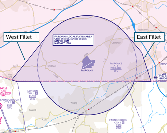
Figure 1 – UK AIP at EGTF AD 2.22.2
The LFA dimensions are promulgated in the UK AIP at EGTF AD 2.22.2
Outside the London CTR, the ATZ to the South extends from the surface to 2,080 feet AMSL and sits partly within the Farnborough CTA-1 (2,000 feet AMSL – 2,500 feet AMSL) (Figure 2).
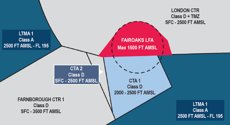
Figure 2
Southerly ARRIVALS/DEPARTURES
Figure 3 – CAA/NATS 1:250,000 England South – Ed.29
Pilots arriving from or departing to the South, must remain outside of all controlled airspace unless they are in receipt of a clearance to enter from Farnborough Radar. It is essential that you remain below 2,000 feet (QNH) when inbound to and outbound from Fairoaks aerodrome.
Prior to flight, pilots should familiarise themselves with both the Worplesdon Railway Station (Figure 4) and Guilford Railway Station (Figure 5) Visual Reference Points (VRP).
Figure 4 – Worplesdon Railway Station VRP
Figure 5 – Guildford Railway Station VRP
When operating within the LFA, remain below 1,500 feet (QNH) in order not infringe the London CTR.
Inbound aircraft and circuit traffic should squawk 7010 when operating in the Fairoaks circuit and LFA/ATZ, unless informed otherwise.
On the leaving the LFA/ATZ to the South and/or operating around Farnborough, pilots are encouraged to obtain an Air Traffic Service (ATS) from Farnborough Radar on 125.250 MHz or to monitor 125.250 MHz and squawk the Frequency Monitoring Code of 4572.
DEPARTING RUNWAY 24
Do not delay your turn to the South on departure from Runway 24. The Farnborough CTR-2 (SFC -2,500 feet AMSL) is approximately 3NM south-west of Fairoaks.
DEPARTING RUNWAY 06
Do not delay your turn to the South on departure from Runway 06. Ensure your initial turn is made well before the M25.
It is essential that you operate on the Fairoaks QNH to avoid entering the Farnborough CTA-1 above. Ensure that climbs are arrested at 1,400 feet within the LFA and thereafter at 1,900 feet until clear of the Farnborough CTA-1 and you maintain a high level of monitoring of your altitude after departing the circuit, beneath the CTA.
Northerly ARRIVALS/DEPARTURES
Pilots planning to arrive from or depart to the North via the London CTR, must obtain a clearance to transit the London CTR.
For further information on routes, please refer to the Fairoaks – Pilots Guide.
In cases of thermic or windy conditions ensure an appropriate altitude below your clearance altitude is maintained so that the clearance limit is not breached and ensure you operate in accordance with the requirements of SERA.3105 Minimum heights.
It should be also noted that wake turbulence from aircraft making approaches to Heathrow Runway 09 may be encountered if transiting the London CTR between Ascot and Burnham.
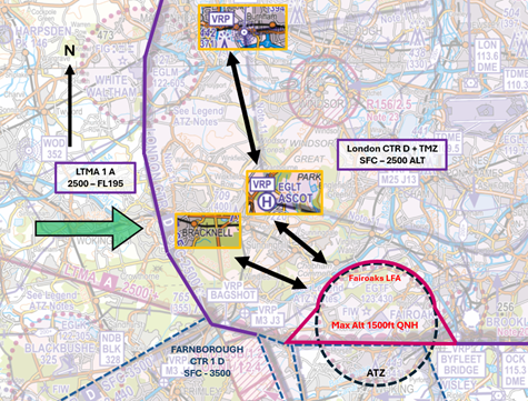
Figure 6 – CAA/NATS 1:250,000 England South – Ed.29
INBOUND LONDON CTR TRANSIT
Depending on departure point, pilots can request a routing from Bracknell, or Burnham VRP – Ascot VRP direct to Fairoaks, both of which may be a more expeditious routing than through Farnborough’s controlled airspace (Figure 6). A request to transit the London CTR must be made to Heathrow Radar 125.625 MHz
EXAMPLE RADIO TRANSMISSION
PILOT: “Heathrow Radar, G-ABCD, request Basic Service and zone transit via Bracknell”
HEATHROW RADAR: “G-ABCD, Heathrow Radar, pass your message”
PILOT: “G-ABCD, PA28, from Kemble to Fairoaks, 2NM West of Reading, altitude 2200 feet QNH 1023, VFR, tracking to Bracknell, request Basic Service and zone transit”
HEATHROW RADAR: “G-CD Roger, Heathrow QNH 1024 Basic Service, squawk XXXX, Report Wokingham”
PILOT: “Basic Service, QNH 1024, squawk XXXX, Wilco, G-CD”
PILOT: “G-CD Reporting Wokingham”
HEATHROW RADAR: “G-CD Roger, cleared to cross the London Control Zone, routeing Bracknell direct Fairoaks, not above altitude 1,200 feet, VFR”
PILOT: “Cleared to cross the London Control Zone, routeing Bracknell direct Fairoaks, not above altitude 1,200 feet, VFR, G-CD”
HEATHROW RADAR: “G-CD Read back correct”
You must not enter controlled airspace unless a clearance has been received
OUTBOUND LONDON CTR TRANSIT
Departing to the North, via the London CTR, plan to use the reverse of the routes described above (Figure 6)
Make your request to transit the London CTR to Fairoaks Radio who will communicate this with Heathrow. You can expect an interaction in the following format:
SCENARIO 1: Heathrow Radar will issue a clearance, which will be relayed by Fairoaks Radio, in the form of “G-ABCD, Heathrow Radar clears you to route to Bracknell, not above 1,200ft VFR, squawk XXXX, next frequency 125.625”
SCENARIO 2: Heathrow Radar requires you to remain within the LFA/ATZ until a clearance has been issued by Heathrow Radar. “G-ABCD, Heathrow Radar requires you remain within the Fairoaks LFA/ATZ, squawk XXXX, next frequency 125.625”
In either of the above scenarios, the initial call to Heathrow Radar would then simply be “G-ABCD squawking XXXX”
You must not enter controlled airspace unless a clearance has been received.
General Circuit Procedures
- Circuits direction is variable
- All procedures are based on the Fairoaks QNH
- Circuit altitude is 1,100 feet for fixed-wing aircraft and 800 feet for rotary aircraft
- Inbound aircraft and circuit traffic should squawk 7010 when operating in the Fairoaks circuit and ATZ/LFA unless otherwise informed
Joining
Fixed-wing aircraft should join the ATZ at 1,400 feet AMSL, and descend to 1,100 feet AMSL when North of the runway prior to turning:
- Downwind for Runway 06 left hand circuit.
- Crosswind for Runway 24 left hand circuit.
- Crosswind for Runway 06 right hand circuit.
- Downwind for Runway 24 right hand circuit.
‘Straight-in’, ‘downwind’ and ‘base’ joins are strongly discouraged when the circuit is active.
Rotary aircraft should enter the ATZ level at 800 feet AMSL and let down south of the runway.
The key to avoiding airspace infringements when operating to/from/at Fairoaks Aerodrome is to have a thorough understanding of the airspace structures and local operating procedures.
Prior to each flight into/from Fairoaks Aerodrome, review local procedures as part of your pre-flight planning. These are clearly explained at:
- United Kingdom AIP EGTF AD2.22 (Flight Procedures) (http://www.nats-uk.ead-it.com/)
- United Kingdom AIP EGLF AD2.17 (Air Traffic Services Airspace) (http://www.nats-uk.ead-it.com/)
- Fairoaks Airport website (Pilots Guide) (https://fairoaks.uk/downloads/)
Aircraft flying in the vicinity of Farnborough CAS
The Airspace & Safety Initiative website provides extensive advice on how to avoid the risk of infringing airspace. You are strongly encouraged to:
- Use a VFR Moving Map. In most of airspace infringements, pilots were either found not to be using a VFR Moving Map or not using one correctly. This was particularly evident during instructional flights where instructor workload is high and distractions highly likely. Using Moving Maps not only gives pilots a profile along the planned route showing controlled airspace above and below the route but it offers airspace warnings. Moving Map technology should not be the sole means of planning or navigation as highlighted in the European General Aviation Safety Team’s Safety Promotion Leaflet and the UK CAA Safety Sense leaflet.
- When flying in proximity to controlled airspace, and able to, pilots are strongly encouraged to apply the Take 2 guidance and operate on the most appropriate altimeter setting when operating under a CTA. In the case of the Farnborough CTA-1, the Fairoaks, Farnborough or London QNH are all acceptable. Consider increasing this distance in cases of thermic or turbulent conditions or where you lack experience or are subject to skill fade. The ‘Take 2’ initiative is neither a buffer based on State policy, nor is its application mandatory; it is merely guidance based on the principle of good airmanship, introduced by pilots to help their fellow pilots and other airspace users.
- Ensure a check of the aircraft’s transponder is conducted on the ground. In cases such as within the Fairoaks LFA whereby it is not possible to ‘Take 2’ whilst joining the fixed-wing circuit at 1,400 feet – ensuring that the transponder’s Mode C (ALT) information is accurate will avoid an erroneous display of an airspace infringement. Prior to the flight, set the altimeter to 1013 hPa and cross check against the transponder’s display. You must ensure the appropriate altimeter subscale setting for your flight is reset prior to departure.
- Understand the impact of forecast weather on your flight. Thermic or turbulent conditions can inadvertently push you upwards. Use the regulated Met Office Aviation Briefing Service in your planning. In addition, refer to Farnborough and Heathrow METARs/TAFs to better visualise local conditions and how they might affect your flight.
- Obtain a Lower Airspace Radar Service (LARS) from Farnborough Radar. Pilots departing Fairoaks and/or operating in the vicinity of Farnborough are encouraged to obtain a LARS from Farnborough Radar on 125.250 MHz; the hours of operation are listed in the UK AIP EGLF AD2.18 or subject to NOTAM action if different.
- Use the FMC rather than squawking 7000/2000. Pilots are encouraged to obtain an Air Traffic Service (ATS) from Farnborough Radar on 125.250 MHz or to monitor 125.250 MHz and squawk the Frequency Monitoring Code of 4572. Obtain the Farnborough QNH by listening to that given to other aircraft on 125.250 MHz. It may also be obtained from the Farnborough ATIS channel 128.405.
- Apply Threat and Error Management when planning and flying. Always consider airspace when making a detailed plan. Build in climb and descent points when routing in the vicinity of multiple CTAs with differing base altitudes. Know what VRPs look like and what airspace lies above them or close by. Identify a point beyond which you are not going to fly if you do not have a positive clearance to enter controlled airspace when departing Fairoaks when cockpit workload is high. A common causal factor in infringement occurrences is distraction; manage that Threat when operating close to controlled airspace.
- If appropriate – request a clearance from Farnborough Radar on channel 133.440. If a climb is required above the base of the CTA, a clearance must be obtained prior to entering.