
This latest narrative has been written by the CAA Airspace Infringement Team in cooperation with members of the London Local Airspace Infringement Team. It features at the ‘top’ of this page but is also as No. 41.
It is supported by a downloadable card as a quick reference: White Waltham Aerodrome guide
This information is for guidance. Any figures or chart extracts are provided for reference only and should not be used in place of regulated sources of information.
White Waltham Aerodrome (EGLM) is situated approximately 12NM west of London Heathrow Airport. The aerodrome has a standard Aerodrome Traffic Zone (ATZ) of 2NM radius extending from the surface to 2,000 feet AAL (2,127 feet AMSL), with the eastern half situated within the London CTR. The Local Flying Area (LFA) is defined as that portion of the ATZ contained within the London CTR.
White Waltham Aerodrome
The MAXIMUM ALTITUDE for traffic within the LFA is 1,500 feet AMSL (QNH).
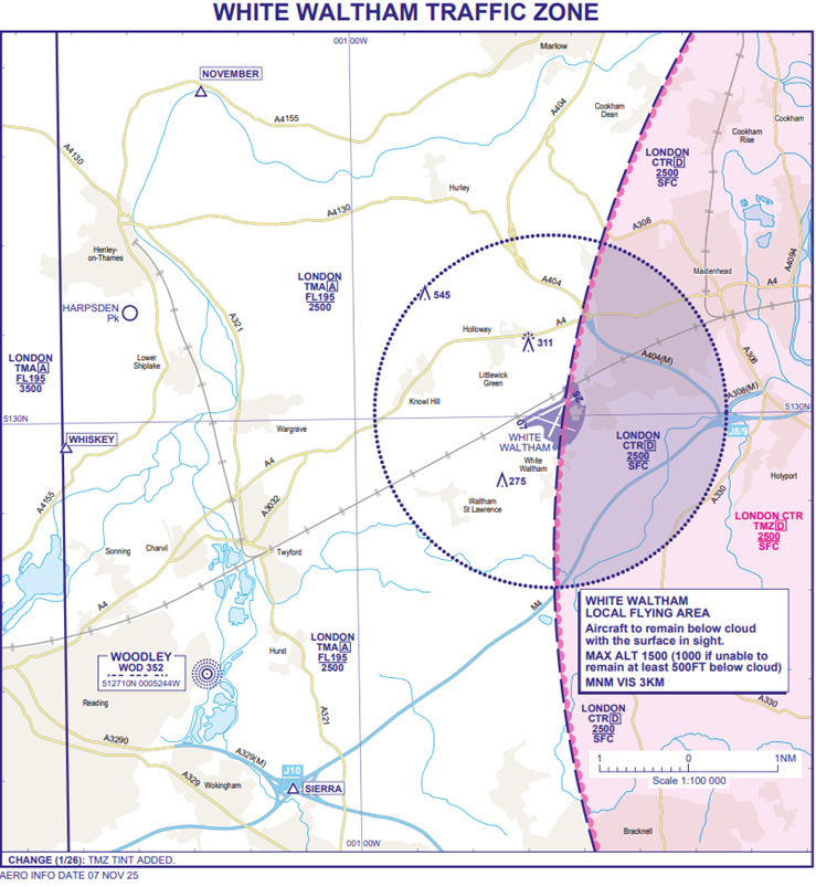
Figure 1 – UK AIP-AD 2.EGLM-4-1 WHITE WALTHAM TRAFFIC ZONE
Hot-spot narratives
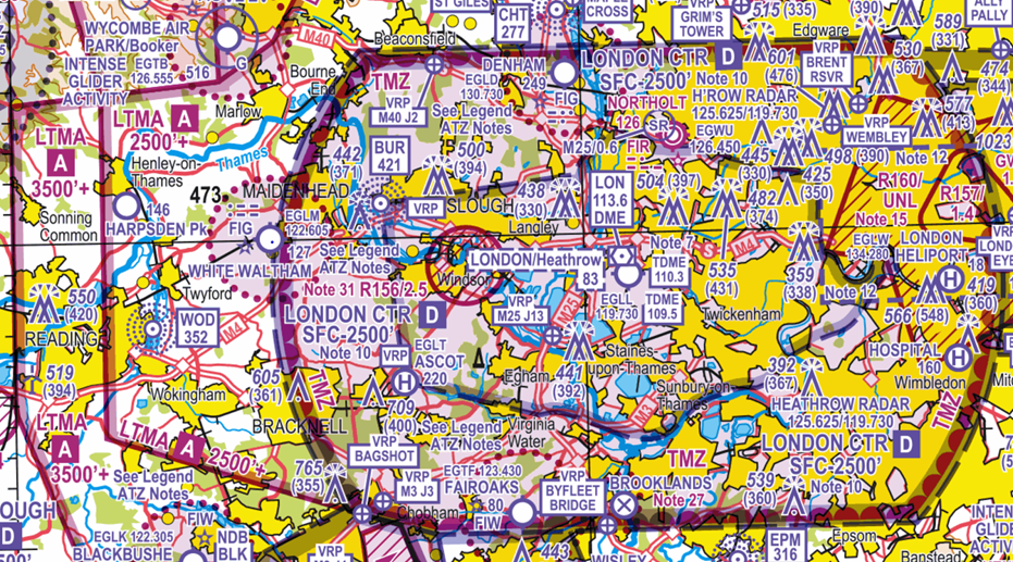
Figure 2: CAA 1:500,000 South – Edition.51The London CTR extends from the Surface to 2,500 feet AMSL and is Class D airspace. The Class A London Terminal Control Area (LTMA-1) extends upwards from 2,500 feet AMSL to FL195.
White Waltham Aerodrome sits in close proximity to London Heathrow Airport, and any airspace infringement of the London CTR and/or the LTMA-1 has the potential to create an immediate safety impact and operational challenges. The location of the aerodrome places local traffic in close proximity to Heathrow arrival and departure routes, meaning every deviation outside the LFA into the CTR can quickly affect controller workload. Infringements around White Waltham carry a high risk of causing disruption, leading to losses of the required 3NM lateral and/or 3,000 FEET vertical separation (LoS) with Heathrow traffic and the implementation of Safety Intervention Measures (SIMs) (Avoiding Action, Vectors, Traffic Information, Stops/Checks on departures).
Effective Planning to Prevent Airspace Infringements
Arrival Procedures
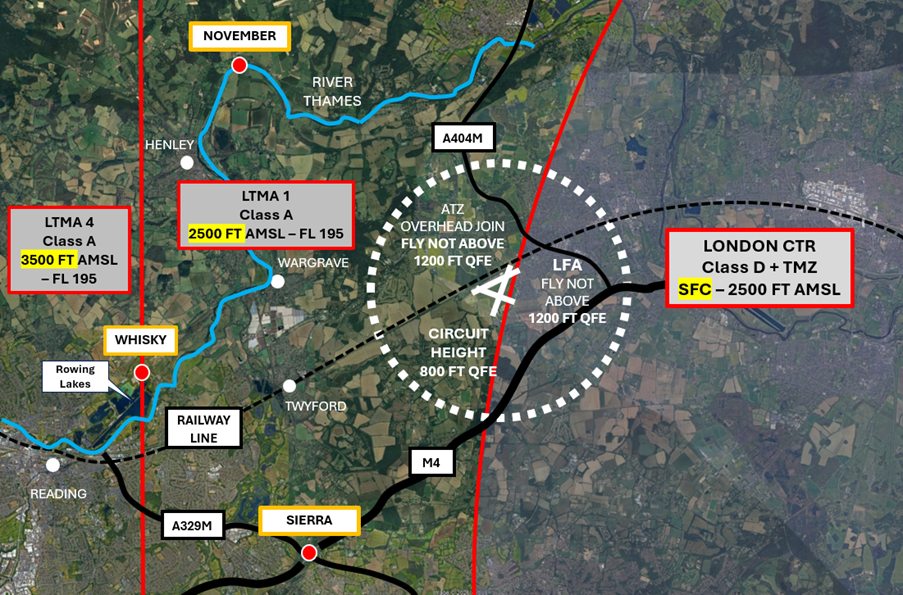
Figure 3 Arrival Procedures
CONTROLLED AIRSPACE (LONDON TMA-1) SITS ABOVE ALL THE REPORTING POINTS FROM 2,500 FEET AMSL TO FL195
Arriving aircraft should contact ‘Waltham Radio’ on channel 122.605 and report their position in relation to, but not necessarily overhead, the appropriate published reporting points:
- November – Bend in the Thames, one mile northeast of Henley (also known as Henley Business School).
Tip: Inbound to White Waltham the Aerodrome is 133 degrees TT and 5NM from point November. - Whisky – Northern tip of the rowing lakes, Northeast of Reading.
Tip: Use the railway line as a guide. When routing inbound to White Waltham aerodrome from the west, the railway line guides you directly to the aerodrome. - Sierra – Junction 10 of the M4
Tip: Inbound to White Waltham from point Sierra, always remain North of the M4 Motorway.
Arrivals from the London CTR
Pilots operating on a VFR or Special VFR clearance in the London CTR inbound to White Waltham aerodrome (or otherwise) must not assume their CTR clearance permits entry to the ATZ.
If in doubt, speak to the operations team for a brief before departing.
DO NOT ENTER NOTIFIED AIRSPACE WITHOUT A CLEARANCE.
Departure Procedures
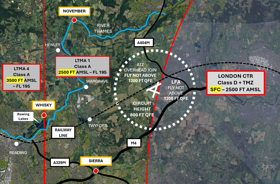
Figure 4 Departure Procedures
CONTROLLED AIRSPACE (LONDON TMA-1) SITS ABOVE ALL THE REPORTING POINTS FROM 2,500 FEET AMSL TO FL195
Follow the circuit pattern until the required departure leg is reached.
White Waltham aerodrome procedures are based on QFE. On departure, if not remaining within the circuit, use the London QNH, Waltham Radio will give this to you when calling on the ground for aerodrome information.
Departing into the London CTR
Pilots requiring a VFR or Special VFR clearance to transit the London CTR must remain within the confines of the White Waltham LFA until a clearance has been obtained from Heathrow Radar on frequency 125.525 MHz.
DO NOT ENTER CONTROLLED AIRSPACE WITHOUT A CLEARANCE
Fixed-Wing Circuit Procedures
CIRCUIT DIAGRAMS ARE LOCATED AT THE END OF THIS NARRATIVE DEPICTING RUNWAY/CIRCUIT SPECIFIC THREATS AND NOISE ABATEMENT

Figure 5 Fixed Wing Circuit Procedures
Fixed-wing circuits are flown left- hand except for Runways 29 and 07L and 07R, which are a right-hand circuit.
Tip: Except for a very small portion of the downwind leg for Runway 21 (Figure 9) ALL circuits should stay North of the M4 and West of the A404M
- All circuits are flown at 800 feet QFE
- Overhead joins are to be flown at 1,200 feet QFE
Conduct an assessment of the threats and errors of each circuit
If in doubt, speak to the operations team for a brief before departing.
Helicopter Routes
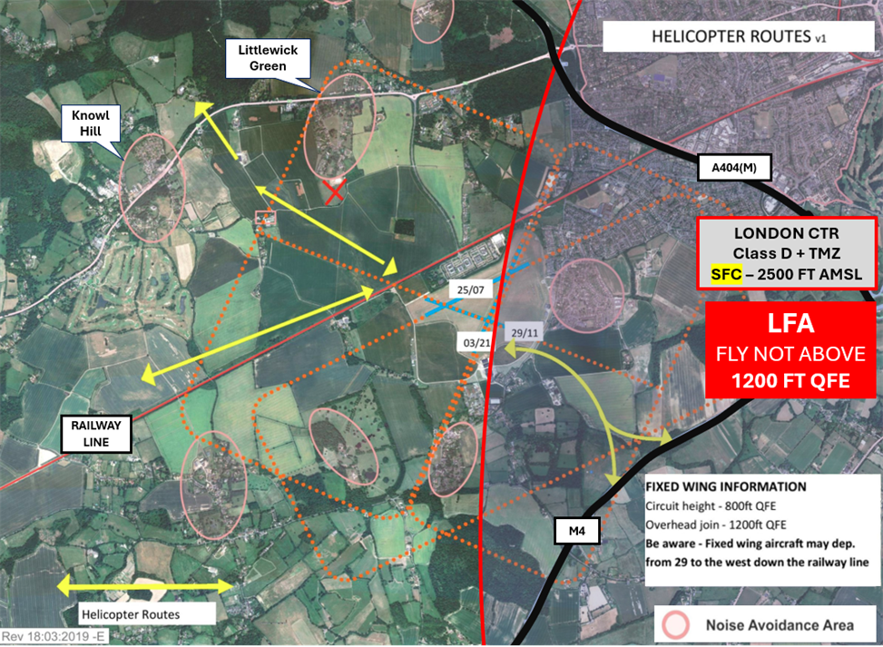
Figure 6 Helicopter Routes
Pilots of helicopters should remain clear of the fixed-wing circuit and approach the aerodrome below the circuit height of 800 Feet QFE.
Important Information – When calling Waltham Radio pilots of helicopters should prefix their callsign with ‘Helicopter’ on each transmission.
This avoids confusion and clearly lets others know that there is a helicopter operating in the vicinity. There are no designated taxiways on the aerodrome. All manoeuvres are at pilots’ discretion.
- Northern Helicopter Route – Approach the aerodrome between the villages of Knowl Hill and Littlewick Green
- Western Helicopter Route – Along the railway line
- Southern and Eastern Helicopter Routes – Along the M4 motorway and toward the Runway 29 Threshold
Pilots of helicopters joining via the Northern and Western Routes should aim to arrive on the aerodrome around the Runway 11 Threshold. If you are visiting Helicopter Services, please remain to the West of Runway 11/29.
Top Tips
- Even before taxiing or arriving via one of the published reporting points, you can start to build your situational awareness as to the aerodrome traffic environment intensity by maintain a listening watch on frequency.
- Make use of the radio. State your position and intentions to enhance situational awareness for all aircraft flying and to comply with Rule 11(3) of The Rules of The Air Regulations 2015.
- Be cognisant of the type of aircraft lining up to depart ahead of you. Consider delaying your departure to maintain spacing and proactively avoid the need to deviate from the published circuit patterns and/or going around.
- When planning (arrival, departure and in the circuit), set lateral and vertical limits, making use of prominent ground features (Railway line, A404M and M4) to help maintain situational awareness as to your position at all times.
- Consider the vertical limits of controlled airspace.
- Consider the wind direction and intensity:
- Ensure the aircraft is flown in accordance with published circuit procedures ground track.
- The runway in use might have changed from when you departed.
- Know your aircraft performance. Think density altitude. How will changes to the weather affect aircraft performance. Consider how you will manage the flight to remain within the LFA.
- Check your altimeter against your transponder to confirm the transponder is serviceable and operating within limits. Before taxiing, set your altimeter sub-scale to 1013 hPa (or 29.92 inHg), check the altitude displayed on your altimeter against the altitude transmitted by your transponder (Mode C/Altitude Reporting). The transponder should be within +/- 125 feet of your altimeter reading. After the check, remember to reset your altimeter to the correct QNH or QFE for departure.
Operational Information
For aerodrome operating hours visit the AIP. PPR is mandatory.
Waltham Radio – channel 122.605
Non radio aircraft are only permitted by prior arrangement and should check the signal square for runway direction before descending below 1,200 feet QFE.
Be aware that drone testing takes place at various locations within the aerodrome boundary up to a height of 400 feet AAL and may be taking place at the thresholds of runways not in use.
For more detailed information on arrival and departure procedures, visit the Pilot Information section at www.wlac.co.uk and/or call the operations team for a briefing on 01628 823272
Preventing an Airspace Infringement
To prevent an airspace infringement, as part of their pre-flight planning and in-flight execution, pilots are strongly encouraged to:
- Read the White Waltham Pilot Information. Available on the aerodrome website – www.wlac.co.uk
The White Waltham Pilot Information page contains details of the LFA, EGLM published reporting points, information relating to arrival/departure tracks and circuit and noise abatement procedures.
- Apply Threat and Error Management when planning and flying. Identify climb and descent points along your route and incorporate ‘Take 2’ wherever possible and mark these points on your chart and VFR Moving Map device as waypoints and incorporate them into your PLOG. Know which EGLM published reporting points are relevant to your flight and what they look like.
- Use a VFR Moving Map in conjunction with a regulated chart to allow you to cross-check your position in-flight. In many airspace infringements, pilots were either found not to be using a VFR Moving Map or not using one correctly. This was particularly evident during instructional flights where instructor workload is high and distractions highly likely. Using Moving Maps not only gives pilots a profile along the planned route showing controlled airspace above and below the route, but it offers airspace warnings. Moving Map technology should not be the sole means of planning or navigation as highlighted in the European General Aviation Safety Team’s Safety Promotion Leaflet and the UK CAA Safety Sense leaflet.
- Use the Farnborough West Frequency Monitoring Code (FMC). Use the FMC rather than squawking 7000/2000. Pilots are encouraged to obtain an Air Traffic Service (ATS) from Farnborough Radar on 125.250 MHz or to monitor 125.250 MHz and squawk the Frequency Monitoring Code of 4572. Obtain the Farnborough QNH by listening to that given to other aircraft on 125.250 MHz. It may also be obtained from the Farnborough ATIS channel 128.405.
- Wherever possible, ‘Take 2’ and remain 200 feet below or 2NM from the boundary of controlled airspace. Pilots are strongly encouraged to apply the Take 2 guidance and operate on the most appropriate altimeter setting. Consider increasing this distance in cases of thermic or turbulent conditions or where you lack experience or are subject to skill fade. The ‘Take 2’ initiative is neither a buffer based on State policy, nor is its application mandatory; it is merely guidance based on the principle of good airmanship, introduced by pilots to help their fellow pilots and other airspace users.
Circuit Diagrams
White Waltham OS Map Circuit 25 Left Hand
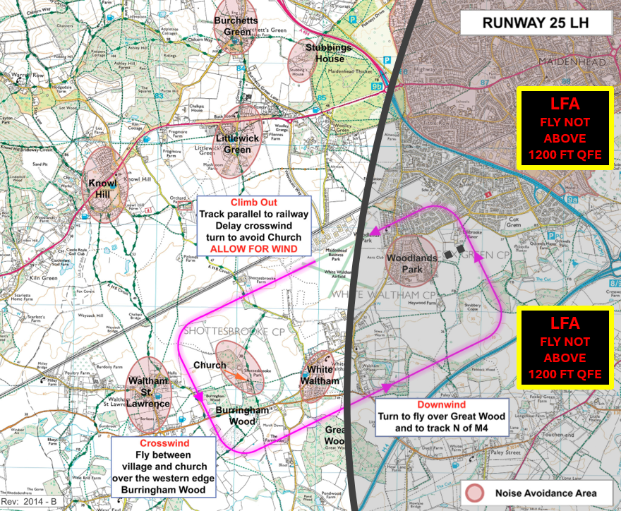
Figure 7 White Waltham OS Map Circuit 25 Left Hand
White Waltham OS Map Circuit 07 Right Hand
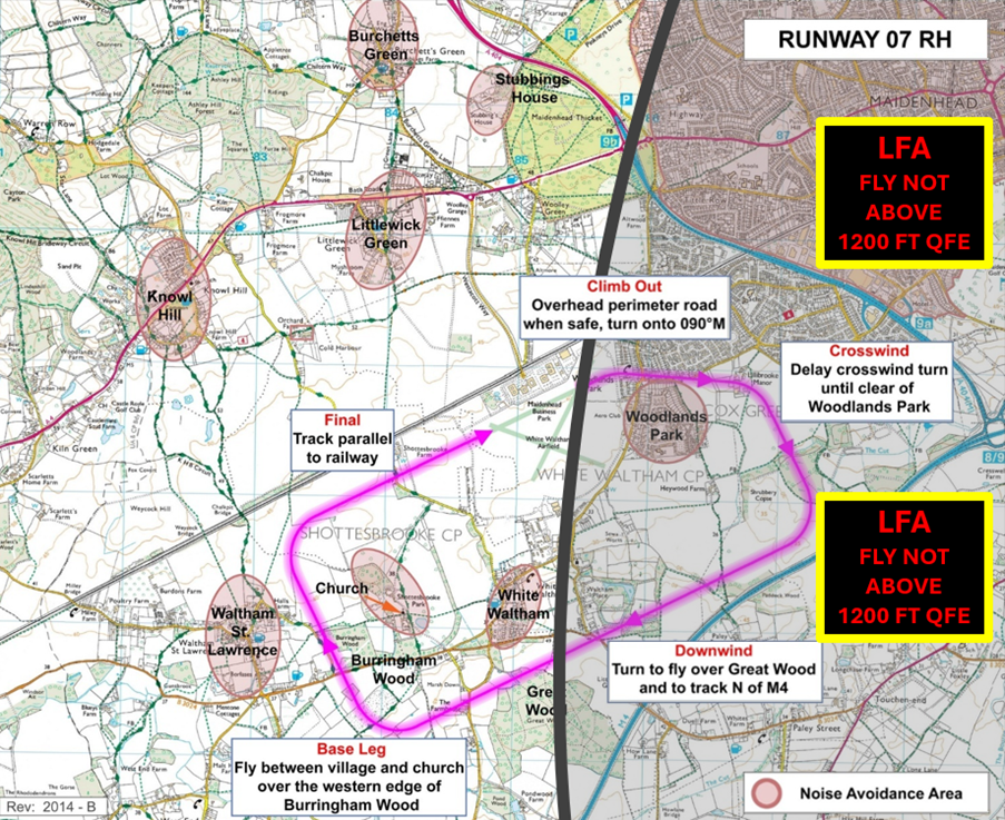
Figure 8 White Waltham OS Map Circuit 07 Right Hand
White Waltham OS Map Circuit 21 Left Hand
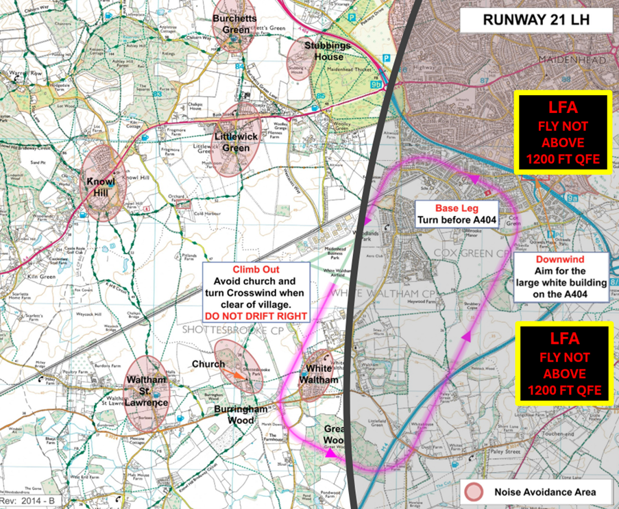
Figure 9 White Waltham OS Map Circuit 21 Left Hand
White Waltham OS Map Circuit 03 Left Hand
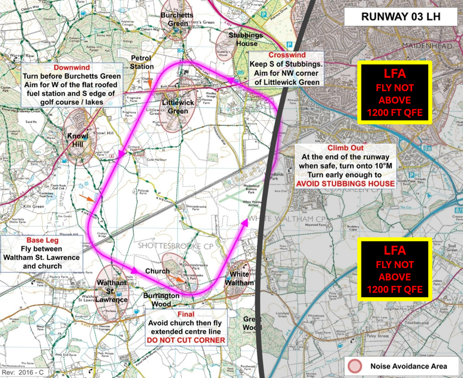
Figure 10 White Waltham OS Map Circuit 03 Left Hand
White Waltham OS Map Circuit 29 Right Hand
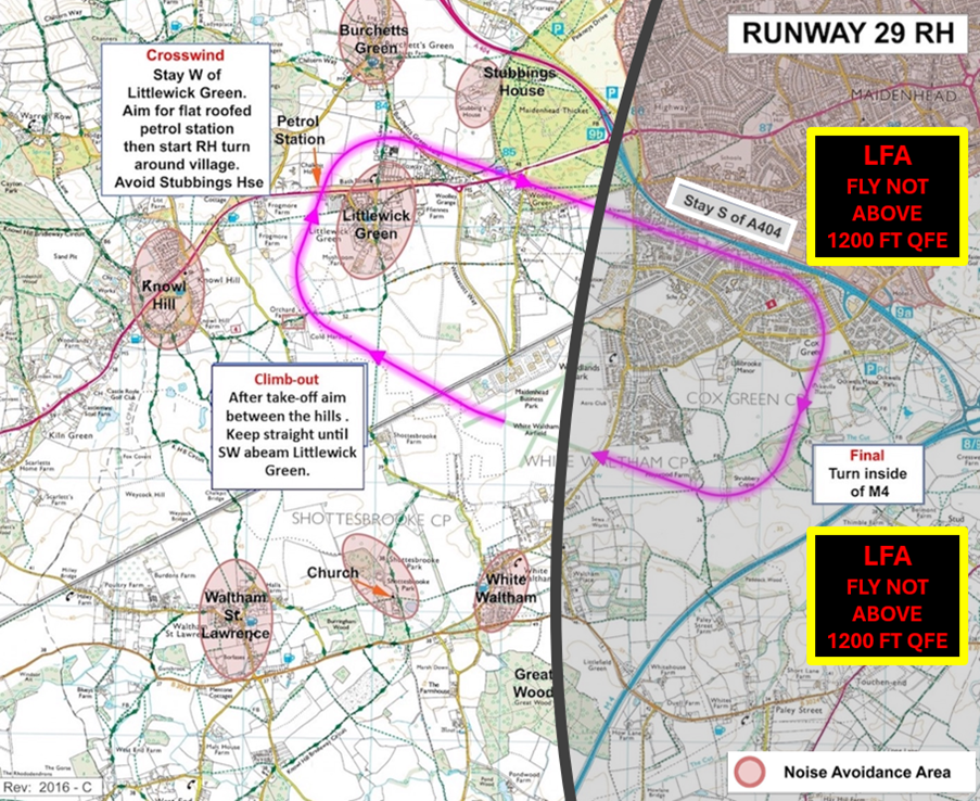
Figure 11 White Waltham OS Map Circuit 29 Right Hand
White Waltham OS Map Circuit 11 Left Hand
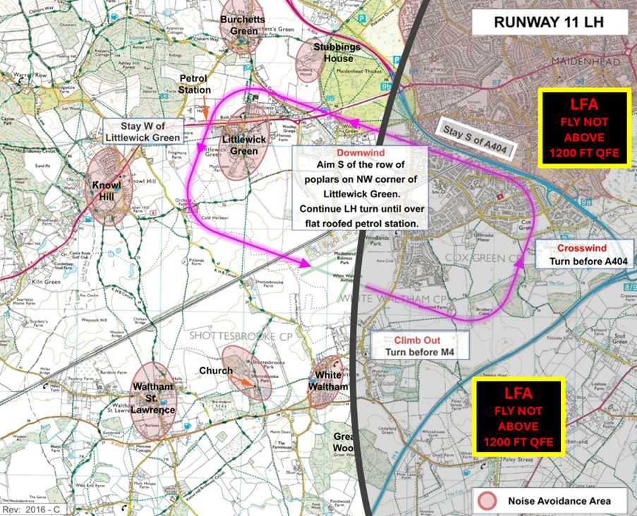
Figure 12 White Waltham OS Map Circuit 11 Left Hand


